- Columbia Point (Boston)
-
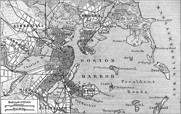
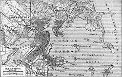 1888 German map of Boston Harbor showing Dorchester in the lower left hand corner.
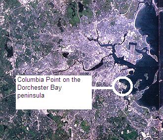
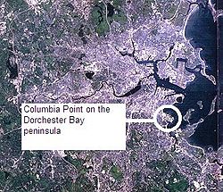 Landsat image of Boston showing Columbia Point peninsula.
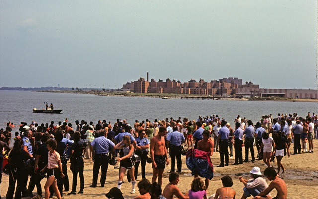
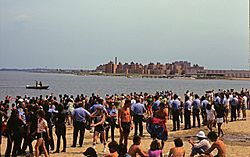 Photo of Columbia Point housing from Carson Beach. The photo depicts a 1977 racial conflict between residents of Columbia Point and South Boston for the use of Carson Beach and the L Street bath house.
 View of Old Harbor at Columbia Point.
Columbia Point, later referred to as Harbor Point, in the Dorchester neighborhood of Boston, Massachusetts sits on a peninsula jutting out from the mainland of eastern Dorchester into the bay.
Contents
History
In Dorchester, Columbia Point was the landing place for Puritan settlers in the early 1600s. The Native Americans called it "Mattaponnock".[1]
The community was, in the 17th and 18th centuries, and through to the mid-19th century, a calf pasture: a place where nearby Dorchester residents took their calves for grazing. It was largely an uninhabited marshland on the Dorchester peninsula. Its size was originally 14 acres (57,000 m2). Many landfills, subsequent to that time, have enlarged the land size to 350 acres (1.4 km2) in the 20th century.[1]
In 1845, the Old Colony Railroad ran through the area and connected Boston and Plymouth, Massachusetts. The station was originally called Crescent Avenue or Crescent Avenue Depot[2] as an Old Colony Railroad station, then called Columbia until December 1, 1982, and then again changed to JFK/UMASS. It is an MBTA rail line station for both the subway and commuter rail line.
In the 1880s, the calf pasture was used as a Boston sewer line and pumping station, known as the Calf Pasture Pumping Station Complex. This large pumping station still stands and in its time was a model for treating sewage and helping to promote cleaner and healthier urban living conditions. It pumped waste to a remote treatment facility on Moon Island in Boston Harbor, and served as a model for other systems worldwide. This system remained in active use and was the Boston Sewer system's headworks, handling all of the city's sewage, until 1968 when a new treatment facility was built on Deer Island. The pumping station is also architecturally significant as a Richardsonian Romanesque designed by the then Boston city architect, George Clough. It is also the only remaining 19th century building on Columbia Point and is in the National Register of Historic Places.[1]
Land-filling had caused the creation of Columbus Park on the peninsula and what was then called “Day Boulevard”, now Morrissey Boulevard, by 1934. There was a huge trash dump on the peninsula which turned into more landfill for other use.
During World War II, small barracks were built on this landfill for some prisoners of war. After the war, these were re-used for the Columbia Point Veterans Village. Also, in 1950, Boston College High School relocated from the South End of Boston to its present home on Morrissey Boulevard.
More landfill on the north shore of the peninsula had been created to build the Columbia Point Development housing projects which were the largest in Boston and New England and built by the Boston Housing Authority. The area was now known as Columbia Point. The Columbia Point Development was completed in 1954 and had 1,500 apartments. Other infrastructure was added, including public schools. The “T” train stop was called Columbia, and is today known as the JFK/UMASS stop on the Red line.
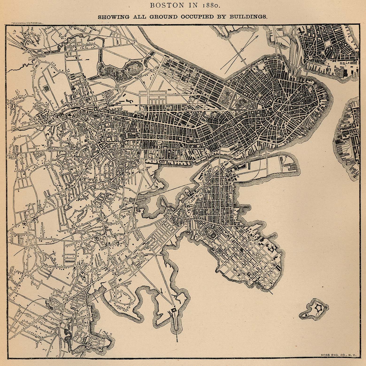
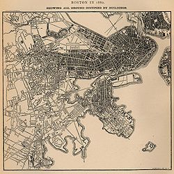 Map showing all ground in Boston occupied by buildings in 1880. Columbia Point is in the center near bottom with two roads going out to the pumping station and calf pasture. From U.S. Census Bureau.
In the 1960s, there was a movement of community residents from the Columbia Point housing projects to get the city dump, which was located on the peninsula, permanently closed. They were able to get attorney F. Lee Bailey interested and to represent them. Eventually, the city dump closed in 1962 and the private dump, called Mile Road Dump, was ordered closed in Fenruary 1963 by the Massachusetts Supreme Court which ruled against its operation.[3]
In 1965, the first community health center in the United States was built on Columbia Point, the Columbia Point Community Health Center, and was founded by two Tufts University medical doctors, Jack Geiger and Count Gibson.[4][5] Geiger had previously studied the first community health centers and the principles of Community Oriented Primary Care with Sidney Kark [6] and colleagues while serving as a medical student in rural Natal, South Africa.[7][8][9] The health center was funded by the federal government's Office of Economic Opportunity (OEO) and was needed to serve the community living in the Columbia Point Public Housing Projects which was on the isolated peninsula far away from Boston City Hospital.[9] The center still stands and is in use today as the Geiger-Gibson Community Health Center on Mount Vernon Street.[10][11]
In 1974, the University of Massachusetts Boston campus was opened on the tip of Columbia Point, and called the Harbor Campus.
In 1977, after an unsuccessful bid to have the John F. Kennedy Library in Cambridge, Massachusetts close to Harvard University, ground was broken at the tip of Columbia Point for the John F. Kennedy Presidential Library and Museum, designed by the architect I. M. Pei, and dedicated on October 20, 1979.
The Columbia Point Housing Projects fell into disrepair and became quite dangerous. By the 1980s only 300 families lived there and the buildings were falling apart. Eventually, realizing the situation was almost hopeless, in 1984 the City of Boston turned over the management, cleanup, planning and revitalization of the property to a private development firm Corcoran-Mullins-Jennison. A 99 year lease from the city of Boston was granted to and co-owned by the (Harbor Point Apartments, L.P.) Harbor Point Community Task Force (tenants' elected board) and a partnership of developers led by Corcoran-Mullins-Jennison Corporation.[12] The construction work for the new Harbor Point development began in 1986. During a recession in 1988 with a slump in the housing market, deficits and expensive loans ($175 million in state and federal loans), the Harbor Point development came close to bankruptcy. Chevron Corporation rescued the redevelopment by investing $34 million, with Chevron taking advantage of $38 million in corporate tax credits and depreciation established by Congress in 1986 encouraging investment in low-income housing.[12][13] The renovation work was fully completed by 1990. It was a beautifully laid out, mixed income community, newly known as Harbor Point Apartments. It received international acclaim for its planning and revitalization from the Urban Land Institute, the FIABCI award, a gold medal with the Rudy Bruner Award for Urban Excellence in 1993 [14][15], and was used as a model for the federal HUD HOPE VI public housing revitalization program begun in 1992.[16]
In 2008, plans and proposals were unveiled and presented to public community hearings by the Corcoran-Jennison Company to redevelop the 30-acre (120,000 m2) Bayside Exposition Center site on the Columbia Point peninsula into a mixed use village of storefronts and residences, called "Bayside on the Point".[17][18][19][20] There have been some serious problems with the on-going development plans, since the Massachusetts Water Resources Authority had planned to build a sewage odor control facility just adjacent to the development site.[21][22]
However, in 2009, the Bayside Expo Center property was lost in a foreclosure on Corcoran-Jennison to a Florida-based real estate firm, LNR/CMAT, who bought it. Soon after, the University of Massachusetts Boston bought the property from them to build future campus facilities.[23][24] In February 2010, The University of Massachusetts Boston in conjunction with the University of Massachusetts Building Authority formally signed the purchase papers and bought the Bayside Expo property for $18.7 million. In 2010, the university plans to break ground and start building the new Edward M. Kennedy Institute for the United States Senate on the campus, as well as a new science laboratory and other facilities.[25][26]
Timeline
(cf. Lawton, University of Massachusetts Boston, research materials)
1630 - Puritan settlers land on Columbia Point. The site is used as a calf pasture for the town of Dorchester until 1869.
1884 - The Sewage pumping station opens at the end of Mile Road.
1942 - Camp McKay, used to house Italian prisoners during World War II, is built on the north side of the peninsula.
1954 - Columbia Point housing project opens and the first tenants move in.
1965 - The Columbia Point Health Center, the first community health center in the country, opens.
1966 - Construction of the Bayside Mall begins.
1971 - Construction of University of Massachusetts Boston begins.
1974 - The Harbor Campus of the University of Massachusetts Boston, opens on Columbia Point.
1975 - Tenants at several public housing projects file suit against the Boston Housing Authority, complaining of sub-standard living conditions.
1978 - The Boston Redevelopment Authority receives a $10 million federal grant for improvements at the Columbia Point housing project.
1979 - The John F. Kennedy Library is formally dedicated.
1984 - The Boston Housing Authority’s receivership ends and Corcoran, Mullins, Jennison, a private development company, takes over the management of Columbia Point, initiating a major cleanup and intensive maintenance improvements.
1985 - The Massachusetts State Archives opens in November.
1986 - The construction of the new Harbor Point housing complex, a mixed-income community, on the site of the former Columbia Point housing projects, begins.
1998 - Harbor Point Apartments achieves a 99% occupancy rate and celebrates its tenth anniversary.
2008 - A proposal for the re-development of the Bayside Exposition Center site into a mixed residential and commercial property to be called "Bayside on the Point" was offered for public perusal.
2009 - The Bayside Exposition Center site is lost in a foreclosure and eventually sold to the University of Massachusetts Boston.
2010 - The University of Massachusetts Boston formally buys the Bayside Expo property for $18.7 million in February 2010Notes
- ^ a b c "Calf Pasture Pumping Station", Dorchester Atheneum
- ^ Whiting, E., Map of Dorchester Massachusetts in 1850 - Boston Public Library Map Collection. The maps shows the Crescent Avenue Depot of the Old Colony Railroad Line.
- ^ Cf. Roessner, Jane, A Decent Place to Live, Chapters 8 ("Columbia Point in the Spotlight"), p.56, and Chapter 13 ("Planning for Columbia Point"), p.107.
- ^ Delta Health Center Records, 1966-1987 in the Southern Historical Collection at the University of North Carolina at Chapel Hill.
- ^ Sargent Shriver, "Remarks of Mr. Shriver at Comprehensive Health Services Press Conference. June 1, 1967". Cf. p.5: "Grantee: Tufts University School Of Medicine, Medford, Massachusetts; Operating Institution: Tufts University School of Medicine-Department of Preventive Medicine; Project Director: Count Gibson, M.D., H. Jack Geiger, M.D., Professors of Preventative Medicine, Tufts University; Location: Columbia Point, Boston, Mass. and Bolivar County, Mississippi; Items of Special Interest: One of the original demonstration programs to contrast a model of a northern urban center with a southern rural one; Amount: $1,168,099, $138,888, $281,685, $3,417,630; Date Approved: 6/24/65, 8/65, 3/30/66, 1/15/67"
- ^ Brown, Theodore M., and Fee, Elizabeth, "VOICES FROM THE PAST: Sidney Kark and John Cassel : Social Medicine Pioneers and South African Emigrés", American Journal of Public Health, November 2002, Vol 92, No. 11, 1744-1745
- ^ Dr. Jack Geiger's biography page at George Washington University,School of Public Health and Health Services
- ^ Dr. Count Gibson's biography at George Washington University, School of Public Health and Health Services
- ^ a b Cf. Roessner, p.80
- ^ "1965 Columbia Point Health Center" - Boston History and Innovation Collaborative
- ^ Kong, Dolores, "25 Years of Intensive Caring", The Boston Globe. October 28, 1990, Metro Section, 29.
- ^ a b "Boston War Zone Becomes Public Housing Dream", The New York Times, November 23, 1991
- ^ Atlantic Capital Corporation, "Harbor Point" and "Track Record"
- ^ "Winner: Harbor Point", The Bruner Foundation, 1993
- ^ "The 1993 Gold Medal Rudy Bruner Award for Harbor Point Redevelopment", Rudy Bruner Award for Urban Excellence, Digital Archive, SUNY University at Buffalo Libraries.
- ^ Cf. Roessner, p.293. "The HOPE VI housing program, inspired in part by the success of Harbor Point, was created by legislation passed by Congress in 1992."
- ^ Stidman, Pete, "Sketches outline new-deal for Columbia Point", Dorchester Reporter, August 14, 2008
- ^ Stidman, Pete, "Bayside developers go public with site plans", Dorchester Reporter, July 17, 2008
- ^ Bayside on the Point website
- ^ Stidman, Pete, "Next great neighborhood' planned for Morrissey site", Dorchester Reporter, November 13, 2008
- ^ Dumcius, Gintautas, "Odor control facility raises new questions on Columbia Point", Dorchester Reporter, February 21, 2008
- ^ Stidman, Pete, "Odor facility clouds future of Bayside project", Dorchester Reporter, November 20, 2008
- ^ Forry, Ed, "UMass-Boston seeks to buy Bayside Expo; Motley says no plans for dorms", The Dorchester Reporter, December 16, 2009
- ^ Anderson, Hil, "Boston’s Bayside Expo Site Sold to University", Trade Show Executive News, December 18, 2009.
- ^ Forry, Ed, "UMass signs agreement to buy Bayside Expo for $18.7M", The Dorchester Reporter, February 18, 2010
- ^ UMass Boston Acquires Former Bayside Property : 20-acre Site Will Support Campus Construction of Academic Buildings", University of Massachusetts Boston, Office of Communications, May 20, 2010
Bibliography
- "Urban Transformations: Columbia Point - Harbor Point, Boston"
- Ball, Joanne, "Can Columbia Point Be Harbor Point? Conversion Represents A Test Of Social Engineering", The Boston Globe, August 14, 1988
- Bressi, Todd, "From the Outside Looking In: An Evaluation of Harbor Point", Places journal, v.8, no.4, Summer 1993, College of Environmental Design, UC Berkeley
- Goody, Joan E., "From Project to Community: The Redesign of Columbia Point", Places journal, v.8, no.4, Summer 1993, College of Environmental Design, UC Berkeley
- Higgins, Richard, "As Columbia Point Is Reborn, Nuns Face Displacement Battle", The Boston Globe, July 23, 1988
- Kamin, Blair, "Rethinking Public Housing", Blueprints magazine, v.15, n.3, Summer 1997 issue, National Building Museum, Washington, D.C.
- Lawton, Heather Block, Research Materials for the book "A Decent Place to Live: from Columbia Point to Harbor Point", University of Massachusetts, Boston, September 2001. (archived 2006)
- Marwell, Stuart; Burke, Bryan; Hudak, Andrew, "Calf Pasture Pumping Station", Boston Public Library, BRA (Boston Redevelopment Authority) collection
- Millson, Rebecca Michelle; Spirn, Anne Whiston, MIT 4.211 course on "The Once and Future City", focusing on Harbor Point/Columbia Point, Spring 2007. (archived 2007)
- Pader, Ellen J; Breitbart, Myrna Margulies, "Transforming Public Housing: Conflicting Visions for Harbor Point", Places journal, v.8, no.4, Summer 1993, College of Environmental Design, UC Berkeley
- Roessner, Jane. "A Decent Place to Live: from Columbia Point to Harbor Point - A Community History", Boston: Northeastern University Press, c2000. ISBN 1555534376
- Silverstein, Nina M.; Conahan, Judith M., &al., "Aging in Place at Harbor Point: Outreach Follow-Up of Older Adults Living in Independent Mixed-Income Apartments", Gerontology Institute and College of Public and Community Service, University of Massachusetts Boston, November 2004
- Thebaud, Angie, et al., "Privately-Funded Public Housing Redevelopment: A Study of the Transformation of Columbia Point", Boston, Massachusetts, September 2008, Institute for International Urban Development
- Vale, Lawrence J., From the Puritans to the projects: public housing and public neighbors, Harvard University Press, 2000. Cf. especially p.255, 357-8, various on Columbia Point Housing Project history.
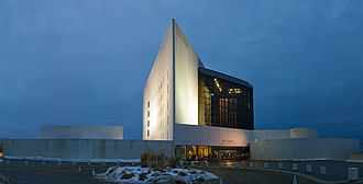 John F. Kennedy Presidential Library and Museum on the Columbia Point peninsula
External links
- Map of Columbia Point - Boston Redevelopment Authority, City of Boston
- "Columbia Point Master Plan" - Boston Redevelopment Authority, City of Boston
- Urban Transformations: Columbia Point - Harbor Point, Boston - presentation slides, Professor David W. Manzo, Boston College
- 1899 Map of Dorchester, Massachusetts with the N.Y. N.H. & H. R.R. running on the Old Colony line - note Mt. Vernon Street and part of Columbia Point in the lower right hand corner
- Boston 1903 map - see the Calf Pasture on Columbia Point in the lower middle right hand side just above Savin Hill

Neighborhoods in Boston Allston/Brighton · Back Bay · Bay Village · Beacon Hill · Charlestown · Chestnut Hill · Chinatown · Columbia Point · Dorchester · Downtown Crossing · East Boston · Fenway–Kenmore · Financial District · Forest Hills · Fort Point · Government Center · Hyde Park · Jamaica Plain · Leather District · Longwood · Mattapan · Mission Hill · North End · Readville · Roslindale · Roxbury · South Bay · South Boston · South End · West End · West Roxbury

Coordinates: 42°18′49.39″N 71°02′00.37″W / 42.3137194°N 71.0334361°WCategories:- Columbia Point, Boston
- Neighborhoods in Boston, Massachusetts
- Boston Harbor peninsulas and former islands


Wikimedia Foundation. 2010.