- Neighborhoods in Boston
-
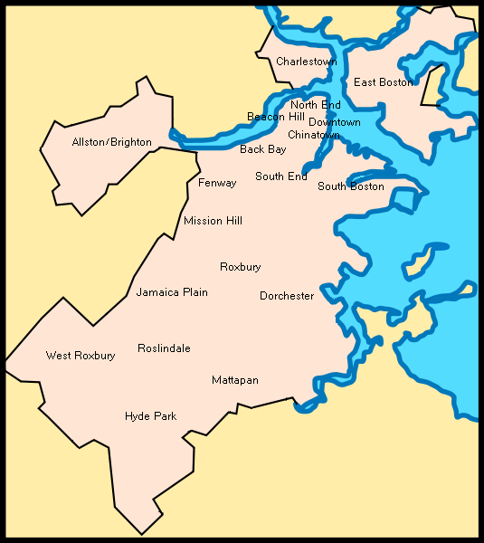
 A map showing the location of 19 of Boston's 21 official neighborhoods (Bay Village and West End not pictured)
Boston is sometimes called a "city of neighborhoods." There are 21 designated neighborhood areas in Boston used by the city.[1] Bostonians also have a variety of overlapping districts which they consider neighborhoods, squares, areas, etc. Many other boundaries established by the city's residential parking districts, the U.S. Postal Service, and a multitude of individual neighborhoods and neighborhood associations exist throughout the city.
"Neighborhoods" exist on both large and small scales. Brighton (including Allston), Charlestown, Dorchester (including South Boston, Mattapan, and Hyde Park), Roxbury (including West Roxbury, Roslindale and Jamaica Plain), have all at some point been municipalities independent from downtown Boston, providing a source of well-defined boundaries for the largest areas. Neighborhood associations often form around much smaller communities, or around a commercial district (often with "Square" in the name) with a well-defined center but poorly identified extremities.
Boston's leveling and expansion by landfill has influenced the naming of certain neighborhoods, such as the Back Bay, South Cove, and Fort Point. The West End, North End, and South End are no longer at those geographic extremities, due to the annexation of surrounding communities. The names originally referred to their positions on the Shawmut Peninsula, the original extent of Boston.[2][3]
Further information: History of Boston, MassachusettsContents
Overview
 Aerial view of the Back Bay and the neighboring City of Cambridge across the Charles River
Downtown Boston is the site of the Financial District, Government Center, Chinatown, and Leather District.
Surrounding downtown are the neighborhoods of the South End, North End, West End, Bay Village, Beacon Hill, and Back Bay. The South End is the center of the city's LGBT population and also populated by artists and young professionals as well as a vibrant African American community.[4] The North End retains an Italian flavor with its many Italian restaurants, though many of its Italian families have moved out, while young professionals have moved in.[5] The Back Bay, west of the Public Garden, is one of the wealthiest neighborhoods in the United States. Beacon Hill, another wealthy neighborhood,[6] is the site of the Massachusetts State House. The Back Bay and Beacon Hill are also home to national and local politicians, famous authors, and top business leaders and professionals. Bay Village is smallest and arguably least known neighborhood in Boston, most of its residents live in small brick row houses.[7][8]
North and east of downtown are the neighborhoods of East Boston and Charlestown. East Boston has a majority a Hispanic and Brazilian population with a remnant of older Italians. On the north bank of the Charles River is Charlestown, once a predominantly Irish enclave and site of the Bunker Hill Monument, now is a haven for young professionals.[7][8][9][10]
West of downtown are the neighborhoods of Fenway-Kenmore, Allston-Brighton and Mission Hill. Fenway/Kenmore borders the campus of Boston University and houses many college students and young professionals and is the location of Fenway Park. Allston/Brighton is populated heavily by students from nearby universities, as well as recent graduates. Mission Hill is adjacent to the Longwood Medical district, full of world-class medical institutions and retains an extremely diverse mix of African Americans, Asian Americans, whites and Latinos.
South of downtown are the neighborhoods of Roxbury, Jamaica Plain, Dorchester, and South Boston. Dorchester is Boston's largest neighborhood and predominantly a working class community considered to be Boston's most diverse. Roxbury is populated largely by African Americans, Caribbean Americans, and Latinos and is historically the center of Boston's black community. Jamaica Plain is a community of white professionals and Latinos, and includes the larger side of the Arnold Arboretum. South Boston is a predominantly Irish-American neighborhood, which hosts the city's annual St. Patrick's Day parade.[7][8][11]
South of Roxbury, Jamaica Plain, and Dorchester are the neighborhoods of Mattapan, Roslindale, Hyde Park, and West Roxbury. Roslindale is known for its small business district and includes the smaller side of the Arnold Arboretum, Roslindale has also recently become a Majority minority neighborhood. Mattapan remains the neighborhood with Boston's highest concentrations of African Americans. Hyde Park and West Roxbury have a distinct suburban feel, while still being a part of the city of Boston. Both neighborhoods have large areas of wooded parks and recreation land. Hyde Park is populated largely by African Americans and Caribbean Americans. Whereas West Roxbury is predominately white with rapidly growing growing African American and Latino populations.[12][13]
Neighborhood areas
The City of Boston is officially divided into 21 neighborhoods for purposes of neighborhood services programs.[14] These are:
- Allston/Brighton
- Back Bay
- Bay Village
- Beacon Hill
- Charlestown
- Chinatown/Leather District
- Dorchester
- Downtown/Financial District
- East Boston
- Fenway/Kenmore
- Hyde Park
- Jamaica Plain
- Mattapan
- Mission Hill
- North End
- Roslindale
- Roxbury
- South Boston
- South End
- West End
- West Roxbury
Some insular territories are administered as part of the Boston Harbor Islands National Recreation Area.
List of places and squares within neighborhood areas
The 21 official neighborhoods in Boston are made up of approximately 84 sub-districts, squares, and neighborhoods within each official neighborhood.The Boston Redevelopment Authority defines 16 planning districts (plus the Boston Harbor Islands) and 64 Neighborhood Statistical Areas (with four areas further subdivided). These correspond roughly with the neighborhoods and sub-neighborhoods of Boston. Unofficially, Boston is made up of approximately 105 neighborhoods.

- Allston/Brighton
- Allston Village
- Brighton Center
- Chestnut Hill
- Cleveland Circle
- Harvard Stadium/Charlesview
- Union Square
- Oak Square
- Faneuil Square
- Brighton Mills
- Lower Allston
- North Brighton
- Packard's Corner
- Soldier's Field
- Back Bay
- Bay Village (also known as South Cove)
- Beacon Hill
- Charlestown
- Bunker Hill
- The Neck
- The Navy Yard[15]
- Hayes Square
- City Square
- Thompson Square
- Sullivan Square[16]
- Chinatown and the Leather District

- Dorchester[17]
- Adams Corner/Adams Village
- Ashmont (including Ashmont Hill, Ashmont-Adams, and Peabody Square)
- Codman Square[18]/Dorchester Center
- Columbia Point/Harbor Point
- Cedar Grove
- Fields Corner
- Four Corners[19]
- Franklin Field
- Grove Hall
- Lower Mills
- Jones Hill
- Meeting House Hill
- Mount Bowdoin
- Neponset
- Polish Triangle
- Popes Hill
- Port Norfolk
- Savin Hill
- Uphams Corner
- Downtown Boston and the Financial District
- Bulfinch Triangle
- Combat Zone (defunct)
- Downtown Crossing/Ladder District
- Fort Hill Square
- Government Center
- Haymarket Square (Boston)
- Post Office Square
- South Station
- Theatre District
- Waterfront
- East Boston
- Bennington Street
- Central Square
- Chelsea Street
- Day Square
- Jeffries Point
- Logan International Airport
- Maverick Square
- Orient Heights
- Fenway/Kenmore
- Audubon Circle
- Back Bay Fens
- Kenmore Square
- Boston University (extends into Allston)
- Longwood Medical Area (extends into Mission Hill)
- Lansdowne Street/Fenway Park
- Hyde Park
- Readville
- Fairmount Hill
- Sunnyside
- Jamaica Plain
- Hyde Square
- Forest Hills/Woodbourne
- Moss Hill
- Mattapan
- Wellington Hill
- Mission Hill
- Brigham Circle
- Back of the Hill
- Parker Hill
- North End
- Ann Street (North Street)
- Hanover Street
- Roslindale
- Roslindale Square
- Roxbury
- Dudley Square
- Egleston Square[20]
- Franklin Park (extends into Jamaica Plain and Dorchester)
- Roxbury Crossing
- South Boston
- Andrew Square (extends into Dorchester)
- D Street
- City Point
- Fort Point
- South Boston Waterfront/Seaport District[21]
- South End
- West End
- Charles Street
- North Station/TD Garden
- Massachusetts General Hospital
- West Roxbury
References
- ^ Boston - A City of Neighborhoods, at CityOfBoston.gov.
- ^ http://www.bc.edu/bc_org/avp/cas/fnart/fa267/bos_fill2.html
- ^ http://www.iboston.org/rg/backbayImap.htm
- ^ http://www.south-end-boston.com/History
- ^ Goldfield, Alex R. The North End: A Brief History of Boston's Oldest Neighborhood. Charlestown, SC: The History Press, 2009.
- ^ http://moneycentral.msn.com/content/invest/forbes/p62020.asp
- ^ a b c Allison, Robert. A Short History of Boston. Boston: Commonwealth Editions, 2004.
- ^ a b c O'Connor, Thomas, H. The Hub: Boston Past and Present. Boston: Northeastern University Press, 2002.
- ^ http://www.relohomesearch.com/USA/MA/Boston/AreaInfo-1319.aspx.
- ^ name="http://www.boston.com/yourtown/news/east_boston/2011/04/census_data_hispanicslatinos_r.html
- ^ Warner, Sam Bass. Streetcar Suburbs: The Process of Growth in Boston, 1870-1900. Cambridge, MA: Harvard University Press, 1978.
- ^ Cite error: Invalid
<ref>tag; no text was provided for refs namedhttp:.2F.2Fwww.boston.com.2Fyourtown.2Fnews.2Fhyde_park.2F2011.2F04.2Fcensus_data_blacksafrican_amer.html; see Help:Cite errors/Cite error references no text - ^ <refname="http://www.boston.com/yourtown/news/mattapan/2011/04/census_data_mattapans_populati.html
- ^ Official Boston neighborhoods, defined here.
- ^ http://www.nps.gov/bost/historyculture/cny.htm
- ^ http://www.cityofboston.gov/bra/pdf/maps/sullivansquare.pdf
- ^ Boston schoolyard sites
- ^ Layout
- ^ Four Corners Main Street
- ^ Egleston Square Neighborhood Association
- ^ http://www.boston-discovery-guide.com/south-boston-waterfront.html#axzz1ZpFEjdOt
External links
- Boston - A City of Neighborhoods. CityOfBoston.gov.
- Maps of Boston neighborhoods
- Alliance of Boston neighborhoods
- Things to Do in Boston's Neighborhoods - Photos & Recommendations
- Boston Neighborhoods
Neighborhoods in Boston Allston/Brighton · Back Bay · Bay Village · Beacon Hill · Charlestown · Chestnut Hill · Chinatown · Columbia Point · Dorchester · Downtown Crossing · East Boston · Fenway–Kenmore · Financial District · Forest Hills · Fort Point · Government Center · Hyde Park · Jamaica Plain · Leather District · Longwood · Mattapan · Mission Hill · North End · Readville · Roslindale · Roxbury · South Bay · South Boston · South End · West End · West Roxbury


Culture & economy Lists & related Attractions · Annual events · Diplomatic missions · Higher Education · Historic Places · Neighborhoods · Nicknames · People · Public Schools · Skyscrapers · Songs · Images · PortalSuffolk County · Boston-Cambridge Metro · Massachusetts · United States Categories:- Neighborhoods in Boston, Massachusetts
- Lists of neighborhoods in U.S. cities


Wikimedia Foundation. 2010.