- Dorchester-Milton Lower Mills Industrial District
-
Dorchester-Milton Lower Mills Industrial District
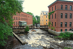
 Neponset River at Lower Mills
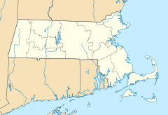
Location: Boston, Massachusetts Coordinates: 42°16′16″N 71°4′8″W / 42.27111°N 71.06889°WCoordinates: 42°16′16″N 71°4′8″W / 42.27111°N 71.06889°W Built: 1868 Architect: Bradlee,Winslow,& Wetherell; et al. Architectural style: Colonial Revival, Other, Romanesque Governing body: Private NRHP Reference#: 80000675
[1]Added to NRHP: April 2, 1980 Dorchester-Milton Lower Mills Industrial District is an historic district on both sides of the Neponset River in the Dorchester neighborhood of Boston, Massachusetts and the Town of Milton, Massachusetts. Dorchester is Boston's largest and most populous community and the largest neighborhood in the city of Boston (which is part of Suffolk County, Massachusetts), with Lower Mills being a sub-neighborhood within Dorchester, and also a neighborhood in Milton. Dorchester is essentially the southern area of Boston and the southernmost area of Dorchester is the sub-neighborhood of Lower Mills (which is bordered to the east by Dorchester Bay and to the south by the Neponset River). Milton is a separate town in Norfolk County, Massachusetts which is located between the Neponset River and the Blue Hills (a state park located in Norfolk County, Massachusetts]. Milton is bordered by Boston (specifically, Dorchester, Mattapan and Hyde Park) to the north, Quincy to the south and east, and Canton and Dedham to the west and has water access to Boston Harbor through the Neponset Estuary.
The Dorchester-Milton Lower Mills Industrial District was built in 1868 and added to the National Register of Historic Places in 1980. Before 1662, Milton was part of Dorchester.
References
- ^ "National Register Information System". National Register of Historic Places. National Park Service. 2008-04-15. http://nrhp.focus.nps.gov/natreg/docs/All_Data.html.
U.S. National Register of Historic Places Topics Lists by states Alabama • Alaska • Arizona • Arkansas • California • Colorado • Connecticut • Delaware • Florida • Georgia • Hawaii • Idaho • Illinois • Indiana • Iowa • Kansas • Kentucky • Louisiana • Maine • Maryland • Massachusetts • Michigan • Minnesota • Mississippi • Missouri • Montana • Nebraska • Nevada • New Hampshire • New Jersey • New Mexico • New York • North Carolina • North Dakota • Ohio • Oklahoma • Oregon • Pennsylvania • Rhode Island • South Carolina • South Dakota • Tennessee • Texas • Utah • Vermont • Virginia • Washington • West Virginia • Wisconsin • WyomingLists by territories Lists by associated states Other This article about a National Register of Historic Places listing in Suffolk County, Massachusetts is a stub. You can help Wikipedia by expanding it.

