- North End, Boston
-
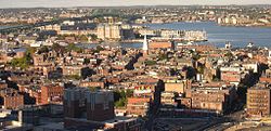
North End — Neighborhood of Boston — Image of the North End, Boston neighborhood. The Old North Church is at center, a Big Dig vent building is near the bottom, and the green Tobin Bridge over the Mystic River is at the top. Country United States State Massachusetts County Suffolk Neighborhood of Boston Time zone Eastern (UTC-5) Zip Code Area code(s) 617 / 857 The North End is a neighborhood of Boston, Massachusetts. It has the distinction of being the city's oldest residential community, where people have lived continuously since it was settled in the 1630s. Though small (⅓ mi²), the neighborhood has approximately 100 eating establishments, and a variety of tourist attractions. It is known as the city's Little Italy for its Italian-American population.
Contents
History
Revolution
In the early stages of the Revolution, the church at which Increase Mather preached was dismantled by the British for use as firewood during the Siege of Boston.[1] Later, the nearby Hutchinson Mansion was attacked by anti-Stamp Act rioters on the evening of August 26, 1765, forcing then Lieutenant Governor Thomas Hutchinson to flee through his garden.[1]
19th Century
Boston prospered in the early 19th Century, and newly wealthy merchants started to move out of the North and the South Ends. They relocated to newer, fashionable neighborhoods like Beacon Hill, leaving behind the longshoremen and dockworkers as well as the boarding houses and taverns.[2][1] After the massive Irish immigration between 1845-1853, the North End was predominantly Irish (the city’s overall population was also affected, going from a predominantly Yankee-Protestant city to being one-third Irish in just a few years).[1]
By the late 1840s, living conditions in the crowded North End were among the worst in the city.[1] Successive waves of immigrants came to Boston and settled in the neighborhood, beginning with the Irish and continuing with German and Russian Jews and Italians.[3] The cholera epidemic of 1849 hit the North End most harshly, claiming most of the seven hundred victims.[4][1]
The Boston Draft Riot of July 14, 1863 began on Prince Street in the North End.[1]
African American Community
In the 19th Century a small community of African Americans lived on Beacon Hill’s north slope and in the North End. David Walker, a used clothing dealer with a shop on Brattle Street, published his Appeal to the Colored Citizens of the World in 1829.[2] Copp's Hill Burying Ground includes both prominent residents and hundreds of African slaves and freemen of color from the early 19th century.[3]
20th Century
In the early 20th century, the North End was dominated by Jewish and Italian immigrants.[3] On Prince Street, three Italian immigrants founded the Prince Macaroni Company, one example of the successful businesses created in this community.[1][5]
The Spanish Influenza Pandemic of 1918 hit the crowded North End severely; so many children were orphaned as a result of the pandemic that the city created the Home for Italian Children to care for them.[1]
The following year, in 1919, the Purity Distilling Company’s 2.3 million gallon molasses storage tank exploded, causing the Great Molasses Flood. A 15 ft wave of molasses flowed down Commercial Street towards the waterfront, sweeping away everything in its path. The wave killed 21 people, injured 150, and caused damage worth $100 million in today's money. [3][6]
In 1927, the Sacco and Vanzetti wake was held in undertaker Joseph A. Langone’s Hanover Street premises. The funeral procession that conveyed Sacco and Vanzetti’s bodies to the Forest Hills Cemetery began in the North End.[1]
In the 1950s the Central Artery was built to relieve Boston’s traffic congestion. The artery walled off the North End from downtown, isolating the neighborhood.[2] Ultimately, the Central Artery was dismantled as part of the Big Dig.[7]
 The Skinny House, reported by the Boston Globe as having the "uncontested distinction of being the narrowest house in Boston," stands near the top of Copp's Hill within sight of Old North Church and the Leonard P. Zakim Bunker Hill Memorial Bridge.
Jane Jacobs, in her book The Death and Life of Great American Cities, used this neighborhood repeatedly as an example of a thriving community, even though the establishment in Boston at that time considered it a slum. She described the North End in 1959 in this way: "The streets were alive with children playing, people shopping, people strolling, people talking. Had it not been a cold January day, there would surely have been people sitting. The general street atmosphere of buoyancy, friendliness, and good health was so infectious that I began asking directions of people just for the fun of getting in on some talk".
Demographics
The North End houses much of the city's Italian-American population. As a result, the North End is enriched with Italian restaurants and ethnic specialty stores. The influx of Italian inhabitants has left a lasting mark on the area; many seminal Italian American institutions have called Boston's North End their home. Some multi-national Italian products companies that began in the North End include Prince Pasta and the Pastene Corporation.[8] Prince Pasta was begun by three Sicilian immigrants: Gaetano LaMarco, Giuseppe Seminara, and Michele Cantella. Pastene was formed by Sicilian immigrant Luigi Pastene. Both companies have grown into million dollar a year businesses, and continue to succeed to this day.
To fully understand the sheer size of the Italian immigrant population, one must look back at the groups that preceded them. The Irish, at their peak, numbered roughly 14,000 and the Jews numbered 17,000. The Italians, however, peaked at over 44,000.[8]
Historic Architecture
Although the North End is part of Boston's original area of settlement, the bulk of the architecture one sees there today dates from the late nineteenth to early 20th centuries (tenement architecture is especially prominent). The neighborhood has a mixture of architecture from all periods of American history, including early structures such as the Old North Church (1723), the Paul Revere House (1680), the Pierce-Hichborn House (1711), and the Clough House (1712).
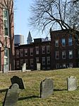
The historic Copp's Hill is the site of Copp's Hill Burying ground, one of America's oldest cemeteries. The cemetery contains many graves dating back to the 17th, 18th, and early 19th centuries including Puritan divines Cotton and Increase Mather and Prince Hall, founder of Prince Hall Freemasonry. The Skinny House, the narrowest house in Boston, is across the street.
The famous Great Brink's Robbery took place in the North End. The Brink's Building in which the robbery took place still stands as the North End Parking Garage, at the corners of Prince St., Hull St., and Commercial St..
The Freedom Trail passes through the North End, making official stops at some of the sites mentioned above.
Education
Primary and secondary schools
The Boston Public School system operates the John Eliot Elementary School [9] in the North End.
St. Johns School is a private Catholic school that serves the area. [10]
The North End is also home to the North Bennet Street School, a trade and craftmanship school that was founded in 1885.[10][11]
Public libraries
The Boston Public Library operates the North End Branch Library. The branch was established in 1913 and moved to its present location in 1963.[12]
Transportation
The North End is accessible via mass transit, including the MBTA's Orange and Green Line at both Haymarket and North Station, by the Blue Line at Aquarium Station, and by the 4, 89/93, 92, 93, 111, 117, 191, 192, 193, 325, 326, 352, 354, 355, 424, 426, 426/455, and 428 bus lines. It is also accessible by ferry at Rowes Wharf.
Notable residents
- John F. Fitzgerald, politician and grandfather to President John Fitzgerald Kennedy.
- Thomas Hutchinson, governor of the Province of Massachusetts Bay shortly before the American Revolution.
- Rose Kennedy, philanthropist and mother to President John Fitzgerald Kennedy.
- Increase Mather, President of Harvard University.
- Charles Ponzi, creator of the Ponzi scheme.
- Paul Revere, 18th-century American activist and artisan.
- David Walker, African-American activist active in the 19th century.
Gallery
-
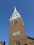
Old North Church with plaque commemorating Paul Revere
-
The Skinny House with Copp's Hill Burying Ground in the foreground
-
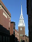
Old North Church and nearby red brick buildings typical of the neighborhood
-
Statue of Saint Francis of Assisi near the Old North Church
-
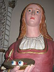
Statue of St. Rita of Cascia at St. Leonard of Port Maurice Church
-
The Copp's Hill Burying Ground in the foreground with the Custom House Tower and One International Place glimpsed in the background
-
Hanover Street scene outside one of the many Italian restaurants for which the North End is known
-
From left to right can be seen the Skinny House, the Leonard P. Zakim Bunker Hill Memorial Bridge, and the Copp's Hill Burying Ground.
References
- ^ a b c d e f g h i j William P Marchione (2008). Boston Miscellany: An Essential History of the Hub. Charleston, SC: History Press.
- ^ a b c Robert J. Allison (2004). A Short History of Boston. Beverly, Mass: Commonwealth Editions. http://www.worldcat.org/oclc/53324893.
- ^ a b c d Anthony Mitchell Sammarco (2007). Boston’s North End. Charleston, SC: Arcadia Publishing.
- ^ "Cholera in Boston, 1849". historyofcaccines.org. http://www.historyofvaccines.org/content/cholera-boston-1849. Retrieved 2011-08-27.
- ^ "Prince - Company Overview and History". prince.newworldpasta.com. http://prince.newworldpasta.com/pasta_story.cfm. Retrieved 2011-08-27.
- ^ "A sticky tragedy: the rupture of a giant molasses tank in Boston just after the First World War caused devastation and led to the longest legal case in the city's history.". History Today. http://go.galegroup.com/ps/i.do?&id=GALE%7CA191856360&v=2.1&u=bkl&it=r&p=SPJ.SP23&sw=w. Retrieved 2011-08-28.
- ^ "The Big Dig". massdot.state.ma.us/. http://www.massdot.state.ma.us/Highway/bigdig/bigdigmain.aspx. Retrieved 2011-08-27.
- ^ a b "Little Italy- Boston". Italianaware.com. http://www.italianaware.com/BostonNorthEnd.html. Retrieved 2011-07-07.
- ^ "Eliot K-8 School". bostonpublicschools.org. http://www.bostonpublicschools.org/school/eliot-k-8-school. Retrieved 2011-09-4.
- ^ a b "Schools & Churches: Northendboston.com". northendboston.com. http://www.northendboston.com/live-2/schools-churches/. Retrieved 2011-09-4.
- ^ "North Bennet Street School: History". nbss.edu. http://www.nbss.edu/about/history/index.aspx. Retrieved 2011-09-4.
- ^ "BPL North End Branch Library". bpl.org. http://www.bpl.org/branches/north.htm. Retrieved 2011-09-04.
Further reading
- Born before plastic: stories from Boston's most enduring neighborhoods; North End, Roxbury, and South Boston, Boston, Massachusetts, USA: City of Boston and Grub Street, Inc., 2007, http://openlibrary.org/books/OL24643200M/Born_before_plastic_stories_from_Boston's_most_enduring_neighborhoods
External links
- NorthEndWaterfront.com, "a non-commercial community website" edited by Matt Conti
- Boston Pictorial Archive. Boston Public Library. Images of the North End, Boston
- North End Boston
- History of the North End
- Oral history project about North End
Neighborhoods in Boston Allston/Brighton · Back Bay · Bay Village · Beacon Hill · Charlestown · Chestnut Hill · Chinatown · Columbia Point · Dorchester · Downtown Crossing · East Boston · Fenway–Kenmore · Financial District · Forest Hills · Fort Point · Government Center · Hyde Park · Jamaica Plain · Leather District · Longwood · Mattapan · Mission Hill · North End · Readville · Roslindale · Roxbury · South Bay · South Boston · South End · West End · West Roxbury

Coordinates: 42°21′54″N 71°03′18″W / 42.364949°N 71.055107°W
Categories:- Neighborhoods in Boston, Massachusetts
- Little Italys in the United States
- Freedom Trail
- North End, Boston
Wikimedia Foundation. 2010.

