- Leonard P. Zakim Bunker Hill Memorial Bridge
Infobox_Bridge
bridge_name = Zakim Bunker Hill Bridge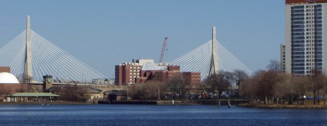
caption = Zakim Bunker Hill Bridge
official_name = Leonard P Zakim-Bunker Hill Memorial Bridge
carries =Interstate 93 andU.S. Route 1
crosses =Charles River
locale =Boston, Massachusetts
maint =Massachusetts Turnpike Authority
id =
design = Hybrid Steel and ConcreteCable-stayed bridge cite web|url=http://www.masspike.com/bigdig/background/crb.html|title=MTA - The Charles River Bridges|author=Massachusetts Turnpike Authority|accessdate=2006-10-19]
mainspan = 745 ft (227.1m)
length = 1432 ft (436.5m)
width = 183 ft (55.7m)
height = 270 ft (98.4m) [ [http://www.massturnpike.com/bigdig/background/crb.html MTA - The Charles River Bridges ] ]
clearance =
below = 40 ft (12.2m)cite web|url=http://www.bostonroads.com/crossings/zakim/|title=Leonard P Zakim-Bunker Hill Memorial Bridge (I-93 and US 1)|author=Eastern Roads|accessdate=2006-10-19]
traffic =
open = March 30, 2003 (NB)
December 20, 2003 (SB)
closed =
toll =
map_cue =
map_
map_text =
map_width =
coordinates = coord|42|22|09|N|71|03|51|W|region:US_type:landmark
lat = 42.3694
long = -71.06427The Leonard P. Zakim Bunker Hill Memorial Bridge is acable-stayed bridge that carries eight lanes of theInterstate 93 andU.S. Route 1 concurrency, plus a two lane access ramp, across theCharles River inBoston, Massachusetts . Finished in 2003, the bridge's unique styling quickly became an icon for Boston, often featured in the backdrop of national news channels to establish location, and included on tourist souvenirs. The bridge is commonly referred to as the "Zakim Bridge" and as the "Bunker Hill Bridge" by residents of nearby Charlestown.The bridge was built as part of the Big Dig, the largest
highway construction project in theUnited States . The entrance to the Thomas P. "Tip" O'Neill Jr. Tunnel, another major component of the Big Dig, is at the bridge's southern end, while north of the bridge I-93 heads towardNew Hampshire and US 1 splits from the Interstate and travels northeast toward Massachusetts' north shore, crossing theMystic River via theTobin Bridge . The bridge replaced theCharlestown High Bridge when it opened, and is the world's widest cable-stayed bridge.Design
In a cable-stayed bridge, instead of hanging the roadbed from cables slung over towers, the cables run directly between the roadbed and the towers. Although cable-stayed bridges have been common in
Europe sinceWorld War II , they are relatively new toNorth America .The bridge concept was developed by Swiss
civil engineer Christian Menn and its design was engineered by American civil engineer Ruchu Hsu with Parsons Brinckerhoff.Boston -based architectMiguel Rosales was the lead architect/urban designer and facilitated community participation during the design process. Neither Hsu nor Rosales served as the designer of record for the project. The engineer of record is HNTB/FIGG. The lead designer fromHNTB was Theodore Zoli; and W. Denney Pate from FIGG. The bridge follows a new design in which two outer lanes arecantilever ed outside the towers while another eight lanes run through the towers. It has a striking, graceful appearance that is meant to echo the tower of theBunker Hill Monument , which is within view of the bridge, and the white cables evoke imagery of the sails of the USS "Constitution".The bridge has an overall length of 436.5 m, a main span of 227.1 m, side spans of 81.4 m (downtown side) and 128.0 m (Charlestown side), and towers that are 82.3 m tall. While the highest wind gusts recorded in Boston were 110 MPH (175 km/h), the bridge is overengineered and is designed to withstand 400 MPH (640 km/h) winds [ [http://www3.whdh.com/weather/wonders WHDH-TV - Pete's Weather Wonders ] ] .
Name
The bridge's full name commemorates both Boston civic leader and civil rights activist
Leonard P. Zakim , who championed "building bridges between peoples", [ cite web |url=http://www.masspike.com/user-cgi/news.cgi?dbkey=54&type=Archived&src=newsarchive |title=Leonard P. Zakim Bunker Hill Bridge Dedication Events Set For October 3-6 |author=MTA press release |date=2002-09-18 |accessdate=2008-04-28 |quote="He worked tirelessly to build personal bridges between our city's diverse people and neighborhoods." - Joyce Zakim, wife of Lenny Zakim] and theBattle of Bunker Hill . Originally Massachusetts Governor A.Paul Cellucci sought to name it the "Freedom Bridge", however in 2000 local clergy and religious leaders, including CardinalBernard Francis Law , requested the Zakim name shortly after Mr. Zakim's death frommyeloma . Gov. Cellucci agreed to the naming, however community leaders from the insular community of Charlestown objected to the name as they felt that since the design reflected the nearby Bunker Hill memorial, it should be named the "Bunker Hill Freedom bridge". Additionally, allegations ofantisemitism were leveled against members of the mostly white, Christian community as reasons for resistance to the Zakim name after questionable quotes appeared in an article in the Boston Globe. However, several community leaders spoke out against the allegations in a press conference, stating that the claims, made by Professor Jonathan Sarna, were his alone and not reflected in the Jewish community at large. [ cite web |url=http://myeloma.org/main.jsp?tab_id=1&type=article&id=457 |title=Lenny's Story: Cancer and the Quality of Life |author=Biography of Lenny Zakim in articles and TV programs |publisher=theInternational Myeloma Foundation |date= |accessdate=2008-04-29 |quote= ]Eventually a compromise between the
Boston City Council , the stateMassachusetts State Legislature and community activists brought about the current name. However like theHoover Dam , different communities will call the bridge by different colloquial names. Many people in the Charlestown area refer to it as the "Bunker Hill bridge", while most, including the local press and traffic monitoring services, refer to it as the "Zakim Bridge".At the time of the naming and sponsoring of the
Boston Garden an article discussing appraisals of the other Boston landmarks suggested the probable amount that the naming of the bridge would have cost a sponsor would have been US$100,000,000.Fact|date=April 2008Notes
*Although the bridge was completed in
2002 , it was not opened to traffic until the northboundCentral Artery tunnel opened in early2003 . The southbound lanes were opened in December 2003, with the opening of the southbound tunnel, and the cantilevered northbound lanes (a two-lane entrance ramp) opened in April2005 , when the old bridge was sufficiently demolished to allow for their completion.
*The Zakim Bunker Hill cable-stayed bridge has been widely seen as an improvement; it acts as a complete replacement for the previous three-lane, dual height steel bridge, theCharlestown High Bridge . The different heights of the lanes of the I-93 elevated highway in Charlestown are the only remaining hints to the layout of the old bridge.
*In March 2005, problems arose when it became apparent that ice falling off the cables during the course of winter could land on the roadway below in large enough chunks to possibly endanger motorists, or even break windshields. [cite web|url = http://www.boston.com/news/local/articles/2005/03/15/bridges_falling_ice_called_fluke_of_nature/|title = Bridge's falling ice called fluke of nature|accessdate = 2006-10-19|author = Daniel, Mac|coauthors = Globe Staff|date =2005-03-15 |publisher =The Boston Globe]
*The Travel Channel ranked the Zakim Bridge 9th in their list of the World's Top Ten Bridges. The article also points out that the bridge is the widest cable-stayed bridge in the world and boasts a total of 10 lanes for traffic. [cite web |url = http://www.travelchannel.com/Travel_Ideas/Road_Trip_U.S.A./ci.World%27s_Top_Ten_Bridges.artTravelIdeasFmt?vgnextfmt=artTravelIdeasFmt |title = World's Top Ten Bridges |accessdate = 2008-02-27 |author = Marathe, Amy |coauthors = |date =N/A |publisher=The Travel Channel]Gallery
References
See also
*
List of crossings of the Charles River External links
* [http://www.leonardpzakimbunkerhillbridge.org The Leonard P. Zakim Bunker Hill Bridge web site]
* [http://www.notfortourists.com/pdfs/boston/NFT_Boston_2007_Transit_Bridges-Tunnels.pdf Fact sheet on the Leonard P. Zakim Bunker Hill Bridge]
*Crossings navbox
structure = Crossings
place =Charles River
bridge = Leonard P. Zakim Bunker Hill Bridge
bridge signs =
upstream =Haymarket North Extension
upstream signs = "MBTA Orange Line"
downstream =Charles River Dam
downstream signs =
Wikimedia Foundation. 2010.