- Storrow Drive
-
Storrow Drive 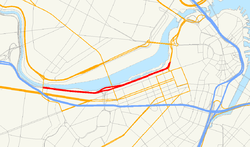
Maintained by: DCR Length: 1.98 mi (3.19 km) West end:  Route 2 (continues as Soldiers Field Road)
Major
junctions: Route 2A
East end:  Route 28(continues as Embankment Road)
 Storrow Drive, Leverett Circle Tunnel
Storrow Drive is a major cross town expressway in Boston, Massachusetts, running south and west from Leverett Circle along the Charles River.[1] It is a parkway—it is restricted to cars; trucks and buses are not permitted on it. The road legally known as James Jackson Storrow Memorial Drive officially ends at its eastward junction with Route 28 and continues as Embankment Road, part of Route 28.
Boston drivers use the route for quick access to downtown locations.[1] Westbound Storrow Drive has a junction with the Harvard Bridge (Route 2A, or Mass. Ave). It passes along the northern edge of Boston University until it reaches a partial junction with the Boston University Bridge (Route 2), where it becomes Soldiers Field Road.
Both Storrow Drive and Soldiers Field Road are maintained by the Massachusetts Department of Conservation and Recreation and are part of the parkway system interconnecting the Emerald Necklace in Boston and Brookline. Together with Memorial Drive and the Cambridge Parkway, Storrow Drive is also part of the Charles River Basin Historic District (listed in the National Register of Historic Places). Prior to 1989, Storrow Drive also carried the U.S. Route 1 designation. (U.S. Route 1 is now routed along Interstate 93).
Contents
Namesake
The parkway is named for James J. Storrow, an investment banker who led a campaign to create the Charles River Basin and preserve and improve the riverbanks as a public park. He had never advocated a parkway beside the river, and his widow publicly opposed it.[2]
Traffic issues
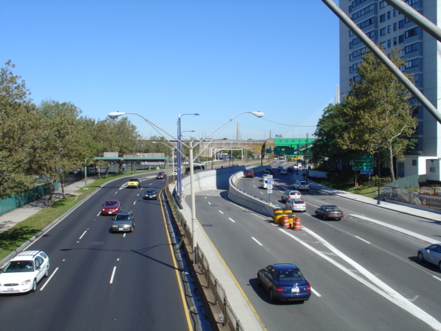
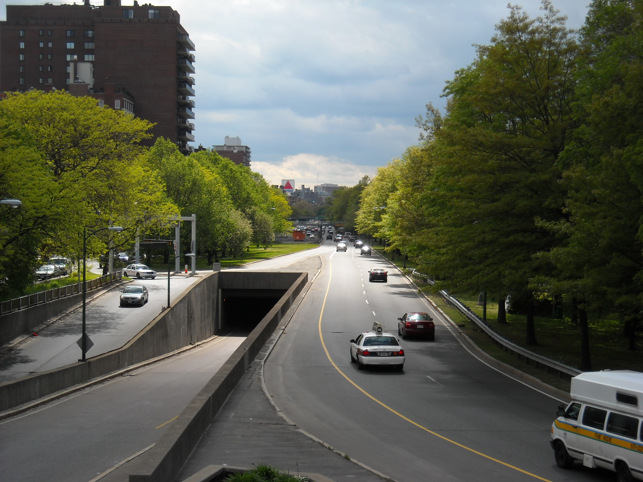
 Storrow Drive mid-afternoon
The road is notorious for speeding and aggressive driving because police enforcement along the road is difficult without a breakdown lane. Radio traffic reports have warned motorists about "ponding" on Storrow Drive, which occurs when snow and frozen ground prevent water from draining properly into storm drains.[3] The underpasses also commonly flood during heavy rains, sometimes stalling low-riding cars.[citation needed]
Concert parking
During some summer night concerts at the Hatch Shell, many drivers park their cars in the outbound lanes of Storrow Drive.[1] The free concerts and fireworks displays attract 200,000 people, and many take advantage of the free parking.[1]
Low clearance
A newcomer to Boston might be surprised at an abundance of signs giving road clearance height.[1] Periodically, despite the signs, a truck or other large vehicle will get wedged under a bridge, which causes traffic to back up for several miles.[1] In one incident a truck full of scissors became stuck and spilled its cargo, causing over 30 cars to get flat tires—two got four flat tires—and the road was backed up well into the afternoon.[1]
History
Between 1958 and 1971, Storrow Drive was designated Massachusetts Route C9.[citation needed]
Early opposition
James Storrow had been instrumental in earlier projects along the Charles River, in particular the Charles River Dam. Additions to the Esplanade had been made during the 1930s only by omitting an important part of the project, a proposed highway from the Longfellow Bridge to the Cottage Farm (Boston University) Bridge, which had provoked tremendous protest.[4] After Helen Storrow, the wife of the now deceased James Storrow, supported a group opposed to the highway, it was dropped;[4] part of the funding was to have come from a million-dollar gift from her.[5] Soon after Helen Storrow's death in 1944, a new proposal for the construction of the highway was pushed through the Massachusetts Legislature. In spite of still strong opposition, and through some dubious parliamentary procedures, the bill approving construction of the highway and naming it after James Storrow was passed in 1949.[6]
Construction
Construction took place in the years 1950–1951. As part of the attempt to preserve park land, any land used by the highway had to be replaced by reclaiming new land along the shoreline.[7] Storrow Drive was officially opened in a ribbon cutting ceremony by Governor Paul A. Dever on 15 June 1951.[8]
Future plans
The Storrow Drive Tunnel, through which Storrow Drive runs along the Esplanade just north of Clarendon, Berkeley and Arlington Streets, has been deteriorating since it was built in 1951, and by mid-2007 the Department of Conservation and Recreation determined that repairing the tunnel may be impossible because it was not waterproofed when it was built, and damage in the intervening years has been significant. Consequently the tunnel may be rebuilt at a cost upward of $200 million, a project that would require closing critical sections of Storrow Drive to traffic.[9]
Despite the chaos this would cause to drivers, it also could present an opportunity for the city to improve the area. For example, Boston Mayor Thomas Menino has proposed covering Storrow Drive near the pedestrian Fiedler Bridge, replacing the old bridge with a wide, ground-level park space that would better connect the green space of Boston's Public Garden with the Esplanade.[10]
Other plans for the road include closing it to traffic Sunday mornings in the summer, much as is done across the river on Memorial Drive. This would create a recreational area for walking, biking and roller blading on weekends, though some have criticized this proposal as unnecessary due to the presence of the Esplanade paths and the existing Memorial Drive road closure. The drive however is usually closed during the July fourth independence celebration at the Esplanade.
Exit list
Exits on Storrow Drive are unnumbered. Mileposts are a continuation from Soldiers Field Road.
Mile Destinations Notes Road continues as Soldiers Field Road 4.1 University Road – Boston University, Brookline Eastbound exit only.
To Route 25.0 Kenmore Square, Fenway Old alignment of U.S. Route 1. 5.1 Route 2A (Massachusetts Avenue) – CambridgeWestbound exit only. 6.0 Route 28 South – Copley Square, Back BayOfficial eastern terminus of Storrow Drive. Road continues as Embankment Road / Route 28 North References
- ^ a b c d e f g Gershkoff, Ira; Richard Trachtman (2004). The Boston Driver's Handbook: Wild in the Streets: The Almost Post Big Dig Edition (3rd ed.). Cambridge, MA: Da Capo Press. pp. 27–29. ISBN 0306813262. OCLC 53970660. http://books.google.com/books?id=Cx4nXwtU2Q8C&lpg=PA28&pg=PA27#v=twopage&f=false.
- ^ Berg, FASLA, Shary Page (January 2007) (PDF). Cultural Landscape Report, The Esplanade, Boston, Massachusetts. The Esplanade Association. p. 33. http://www.esplanadeassociation.org/news/documents/landscperprt_website.pdf. Retrieved 2009-05-03.
- ^ Amsterdam, Dick; Nancy Parsons (2000). Morsels from the Better Mousetrap: Tips, Tricks and Tales About Corporate Communications for Small Businesses. Xlibris Corporation. p. 143. ISBN 0738816744. OCLC 0738816744.
- ^ a b Seasholes, Nancy S. (2003). Gaining Ground: A History of Landmaking in Boston. Cambridge, MA: MIT Press. p. 206. ISBN 0262194945. OCLC 470179960. http://books.google.com/books?id=GAHs1C9q1EsC&lpg=PA206&pg=PA206#v=onepage&f=false.
- ^ "Fight begins on $4,855,000 Basin Project", Boston Evening Transcript, March 6, 1929.
- ^ "Embankment Road approved by House in stormy session", The Boston Globe, April 29, 1949.
- ^ Massachusetts General Court Acts of 1949, Chap. 262
- ^ "Massachusetts Road Opened". The New York Times: Sports section, Page 13. 1951-06-16. http://select.nytimes.com/gst/abstract.html?res=F10A1EFF3C5B16738FDDAF0994DE405B8189F1D3. Retrieved 2007-02-22.
- ^ "Storrow Tunnel may need replacing". The Boston Globe. 2007-07-24. http://www.boston.com/news/local/articles/2007/07/24/storrow_tunnel_may_need_replacing/. Retrieved 2008-05-05.
- ^ "New vision over Storrow Drive". The Boston Globe. 2008-03-19. http://www.boston.com/bostonglobe/editorial_opinion/editorials/articles/2008/03/19/new_vision_over_storrow_drive/. Retrieved 2008-05-05.
Metropolitan Park System of Greater Boston Coastal reservations Belle Isle Marsh • Boston Harbor Islands • Castle Island • Dorchester Shores • Fort Revere Park • Lynn Shore • Nahant Beach • Nantasket Beach • Quincy Shore • Revere Beach • Rumney Marsh • Webb Memorial State Park • Weymouth Back RiverRiver reservations Alewife Brook • Charles River • Chestnut Hill • Cutler Park • Elm Bank • Hemlock Gorge • Mystic River • Neponset River • Pope John Paul II Park • Squantum Point Park • Upper Charles RiverWoodland reservations Beaver Brook • Blue Hills • Breakheart • Hammond Pond • Middlesex Fells • Quincy Quarries • Southwest Corridor Park • Stony Brook • Wilson MountainHeritage state parks Parkways and roads Alewife Brook Parkway · Arborway · Blue Hills Parkway · Blue Hills Reservation Parkways · Charles River Reservation Parkways · Day Boulevard · Fells Connector Parkways · Fenway · Fresh Pond Parkway · Furnace Brook Parkway · Hammond Pond Parkway · Hull Shore Drive · Jamaicaway · Lynn Fells Parkway · Memorial Drive · Morrissey Boulevard · Mystic Valley Parkway · Nahant Beach Boulevard · Nantasket Avenue · Park Drive · Quincy Shore Drive · Revere Beach Parkway · Riverway · Soldiers Field Road · Stony Brook Reservation Parkways · Storrow Drive · Truman Parkway · VFW Parkway · West Roxbury Parkway • Winthrop Parkway • Winthrop Shore DriveStreets Arborway · Atlantic Avenue · Beacon Street · Bennington Street · Bowdoin Street · Boylston Street · Brookline Avenue · Charles Street · Commonwealth Avenue · Congress Street · Court Street · Dorchester Avenue · Fenway · Gallivan Boulevard · Hanover Street · Huntington Avenue · Jamaicaway · Massachusetts Avenue · Melnea Cass Boulevard · Milk Street · Morrissey Boulevard · Morton Street · New Chardon Street · Newbury Street · North Street · Park Street · Riverway · School Street · State Street · Storrow Drive · Summer Street · Tremont Street · Union Street · Washington Street · Winter Street · Yawkey Way
Squares, Circles,
Crossings and
CornersAndrew Square · Brigham Circle · Central Square · Chester Square · City Square · Cleveland Circle · Codman Square · Copley Square · Day Square · Dewey Square · Dock Square · Downtown Crossing · Dudley Square · Egleston Square · Fields Corner · Haymarket Square · Hyde Square · Jackson Square · Kenmore Square · Louisburg Square · Maverick Square · Packard's Corner · Park Square · Peabody Square · Post Office Square · Roxbury Crossing · Sullivan Square · Thompson Square · Union Square · Uphams CornerCategories:- Streets in Boston, Massachusetts
- Parkways in Massachusetts

Wikimedia Foundation. 2010.