- Metropolitan Park System of Greater Boston
-
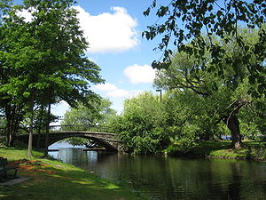 Pedestrian bridge, Charles River Esplanade, Boston, Massachusetts
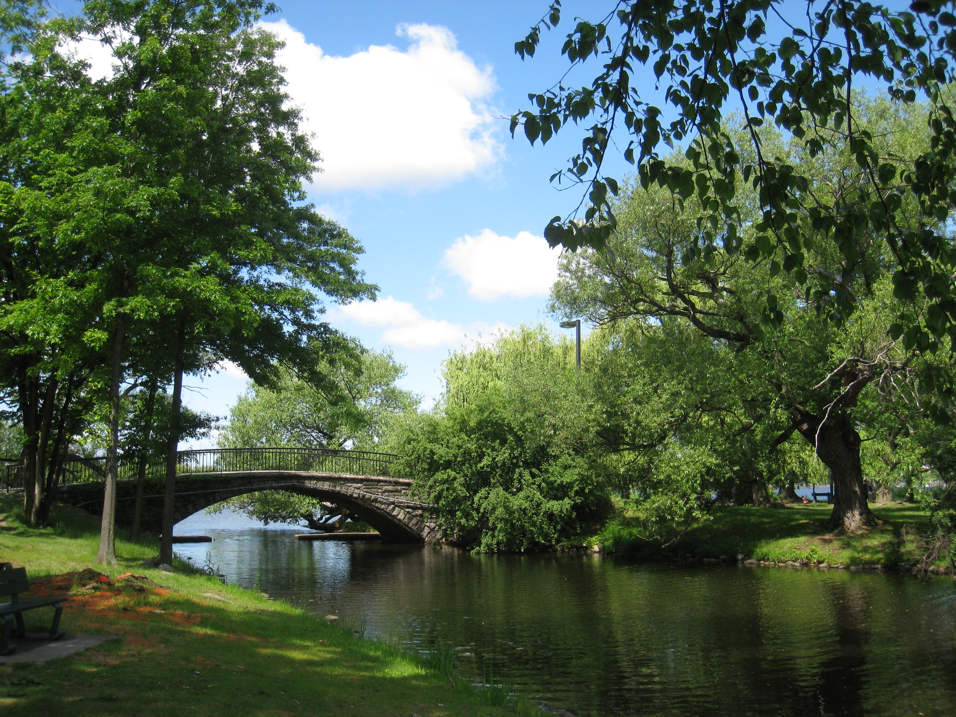
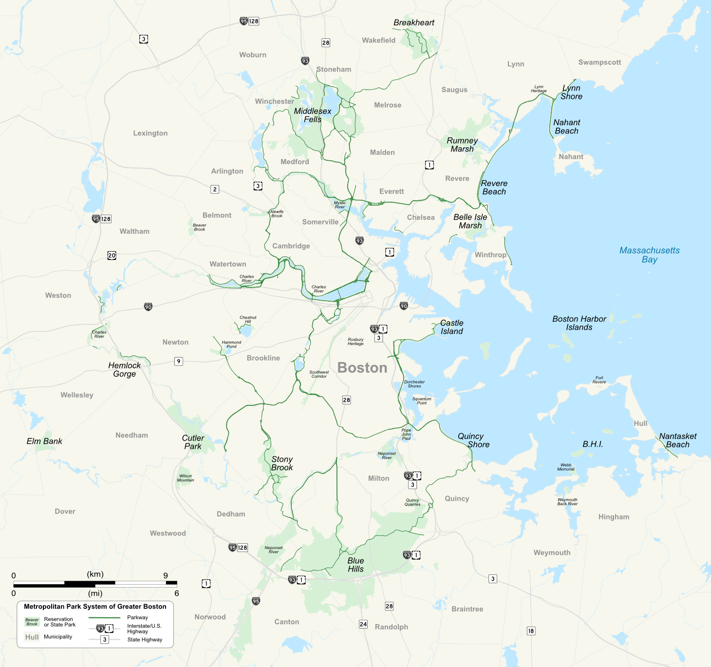
 Metropolitan Park System map
The Metropolitan Park System of Greater Boston is a system of reservations, parks, parkways and roads under the control of the Massachusetts Department of Conservation and Recreation (DCR) in and around Boston that has been in existence for over a century.[1] The title is used by the DCR to describe the areas collectively: "As a whole, the Metropolitan Park System is currently eligible for listing on the National Register of Historic Places", as outlined on the department's website.[2] The DCR maintains a separate Urban Parks and Recreation division to oversee the system, one of five such divisions within the department—DCR's Bureau of State Parks and Recreation manages the remainder of Massachusetts state parks. Direct design and maintenance functions for the parkways and roads within the system are provided by the DCR Bureau of Engineering.[3]
The park system consists of coastal reservations and beaches including Revere Beach, river reservations along the three major rivers in the area, such as the Charles River Reservation, and woodland reservations exemplified by Blue Hills Reservation south of the city. In addition, parks focusing on local history are located in Lynn and Roxbury. The DCR also manages a system of parkways which serve to connect the urban public to the open spaces; among these are busy streets such as Jamaicaway in Boston as well as secluded park roadways in uninhabited areas such as the Blue Hills Reservation Parkways.[1]
History
The improvement of areas of undeveloped land, detrimental development, and polluted land in and around Boston for a system of interconnected parks was first conceived and promoted by landscape architect Charles Eliot and Sylvester Baxter, a Boston newspaper writer and city planning enthusiast.[2][4] Eliot had apprenticed with Frederick Law Olmsted and later assumed leadership of Olmsted's design firm in 1893. Olmsted had been responsible for the development of Central Park in Manhattan and with Eliot had worked to create Boston's Emerald Necklace, a string of connected parks and waterways.[5] Eliot was instrumental in the founding of The Trustees of Public Reservations (now The Trustees of Reservations) and the public Metropolitan Parks Commission in the 1890s and envisioned an expansion of the parks network to areas surrounding Boston.[5]
The original Metropolitan Park Commission appointed by the legislature in 1892 consisted of Charles Francis Adams, Jr., Philip A. Chase and William B. de las Casas. The commission hired Baxter to serve as secretary and Eliot as landscape architect.[6] The first five areas acquired by the commission for the system in 1893 were the Beaver Brook, Blue Hills, Hemlock Gorge, Middlesex Fells and Stony Brook Reservations.[7] By 1900, the system had expanded to include several constructed or planned parkways and added beach reservations at King's Beach in Lynn, Nantasket Beach in Hull, Quincy Shore, Revere Beach, and reservations along the Charles, Mystic and Neponset Rivers.[8]
In 1919, the commission was renamed the Metropolitan District Commission (MDC) after merging with the Metropolitan Water and Sewer Commission.[2][9] Through the next 80 years the MDC became increasingly politicized and known as a haven for political patronage.[10] Following a series of failures within the commission resulting in the pollution of Boston Harbor in the 1970s, the City of Quincy sued the MDC and the separate Boston Water and Sewer Commission in 1982, charging unchecked systemic pollution of the city’s waterfront. That suit was followed by one by the Conservation Law Foundation and finally by the United States Government, resulting in a landmark court-ordered cleanup of Boston Harbor.[11] The lawsuits forced then Massachusetts Governor Michael Dukakis to propose separating the water and sewer treatment divisions from the MDC, resulting in the creation of the Massachusetts Water Resources Authority in 1985. Charges of political corruption and patronage continued to follow the MDC, while the loss of revenue from removal of the payments brought in by water and sewer services created a need for increased funding from the state legislature.[9] The situation resulted in calls for the dismantlement of the MDC,[9] which was realized when the MDC was dissolved by legislation in 2003. The Metropolitan Park System and other operations of the MDC were merged with the Massachusetts Department of Environmental Management to form the current Department of Conservation and Recreation.[12][13] In 2009, a study concerning the transfer of DCR managed roadways to the Massachusetts Department of Transportation was begun, following the transfer of all DCR non-pedestrian bridges as part of a major transportation reform law enacted that year.[14][15]
Parks and reservations
The following table lists parks and reservations currently owned and maintained by the DCR Division of Urban Parks and Recreation, subdivided into sections based on environment as stated by the DCR, with year of formation, location within municipalities, site area and primary activities listed:
Metropolitan parks and reservations[1][16] Coastal NameYear formedMunicipalities Area in
acres (hectares)Activities Belle Isle Marsh 1985[17] Boston 241 (98) Hiking, Scenery Boston Harbor Islands 1970[18] Boston, Hingham, Quincy, Weymouth 404 (163) Boating, Camping, Fishing, History, Picnicking, Scenery, Swimming, Walking Castle Island 1962[19] Boston 22 (8.9) Fishing, History, Picnicking, Scenery, Swimming, Walking Dorchester Shores 1988[20] Boston 41.3 (16.7) Fishing, Picnicking, Swimming Fort Revere Park 1988[21] Hull 8 (3.2) Events, History, Scenery Lynn Shore 1896[22] Lynn 22 (8.9) Biking, Birding, Fishing, Playing Fields, Swimming Nahant Beach ~1900[5] Nahant 66.5 (26.9) Boating, Fishing, Playing Fields, Swimming Nantasket Beach 1899[23] Hull 26 (11) Biking, Swimming, Walking Quincy Shore 1899[24] Quincy 86 (35) Biking, Fishing, Picnicking, Running, Swimming, Walking Revere Beach 1896 Revere 84 (34) Fishing, Picnicking, Playground, Swimming Rumney Marsh 1992[25] Saugus 600 (240) Birding, Fishing, Hiking, Kayaking Webb Memorial State Park 1977[26] Weymouth 36 (15) Canoeing, Picnicking, Scenery, Walking Weymouth Back River 1987[27] Hingham, Weymouth 35 (14) Birding, Fishing, Hiking, Soccer River Alewife Brook 1906[28] Arlington, Cambridge 120 (49) Birding, Hiking, Playing Fields, Running, Tennis Charles River 1896 Boston, Cambridge, Dover, Needham, Newton, Watertown, Wellesley, Weston 870 (350) Athletic Fields, Boating, Canoeing, Concerts, Running, Sailing, Tennis, Walking Chestnut Hill 2002[29] Boston 120 (49)[29] Fishing, History, Swimming Pool, Skating, Walking Cutler Park 1962 Dedham, Needham, Newton 700 (280) Hiking, Picnicking Elm Bank 1995[30] Dover 182 (74) Birding, Fishing, Hiking, Kayaking, Museum Hemlock Gorge 1895[31] Needham, Newton 23 (9.3) Hiking, Picnicking Mystic River 1896 Arlington, Everett, Medford, Somerville 396 (160) Biking, Boating, Hiking, Rowing, Running, Sailing, Soccer, Swimming, Tennis Neponset River 1896 Boston, Canton, Milton 750 (300) Birding, Boating, Fishing, Hiking, Kayaking Pope John Paul II Park 2001 Boston 66 (27) Birding, Hiking, Kayaking, Running, Soccer Squantum Point Park 2001 Quincy 25 (10) Birding, Canoeing, Inline Skating, Running, Scenery Woodland Beaver Brook 1893 Belmont, Waltham 59 (24) Baseball, Birding, Hiking, Picnicking Blue Hills 1893 Braintree, Canton, Milton, Quincy, Randolph 7,000 (2,800) Camping, Fishing, Horseback Riding, Mountain Biking, Rock Climbing, Skiing, Swimming Breakheart 1934 Saugus, Wakefield 640 (260) Biking, Fishing, Hiking, Skiing, Swimming Hammond Pond 1938[32] Newton 59 (24) Fishing, Hiking, Rock Climbing Middlesex Fells 1894[33] Malden, Medford, Melrose, Stoneham, Winchester 2,575 (1,042) Canoeing, Fishing, Horseback Riding, Kayaking, Mountain Biking, Rock Climbing, Skiing Quincy Quarries 1985[34] Quincy 22 (8.9) Hiking, Picnicking, Rock Climbing, Scenery Southwest Corridor Park 1987 Boston 52 (21) Basketball, Biking, Tennis, Walking Stony Brook 1894 Boston, Dedham 475 (192) Baseball, Biking, Fishing, Hiking, Picnicking, Swimming Pool, Skating Rink, Tennis Wilson Mountain 1995 Dedham 213 (86) Birding, Hiking Heritage Lynn Heritage State Park 1990 Lynn 4.2 (1.7) History, Scenery, Walking Roxbury Heritage State Park 1992 Roxbury 2.2 (0.89) Architectural History, Community Programs, History Notes
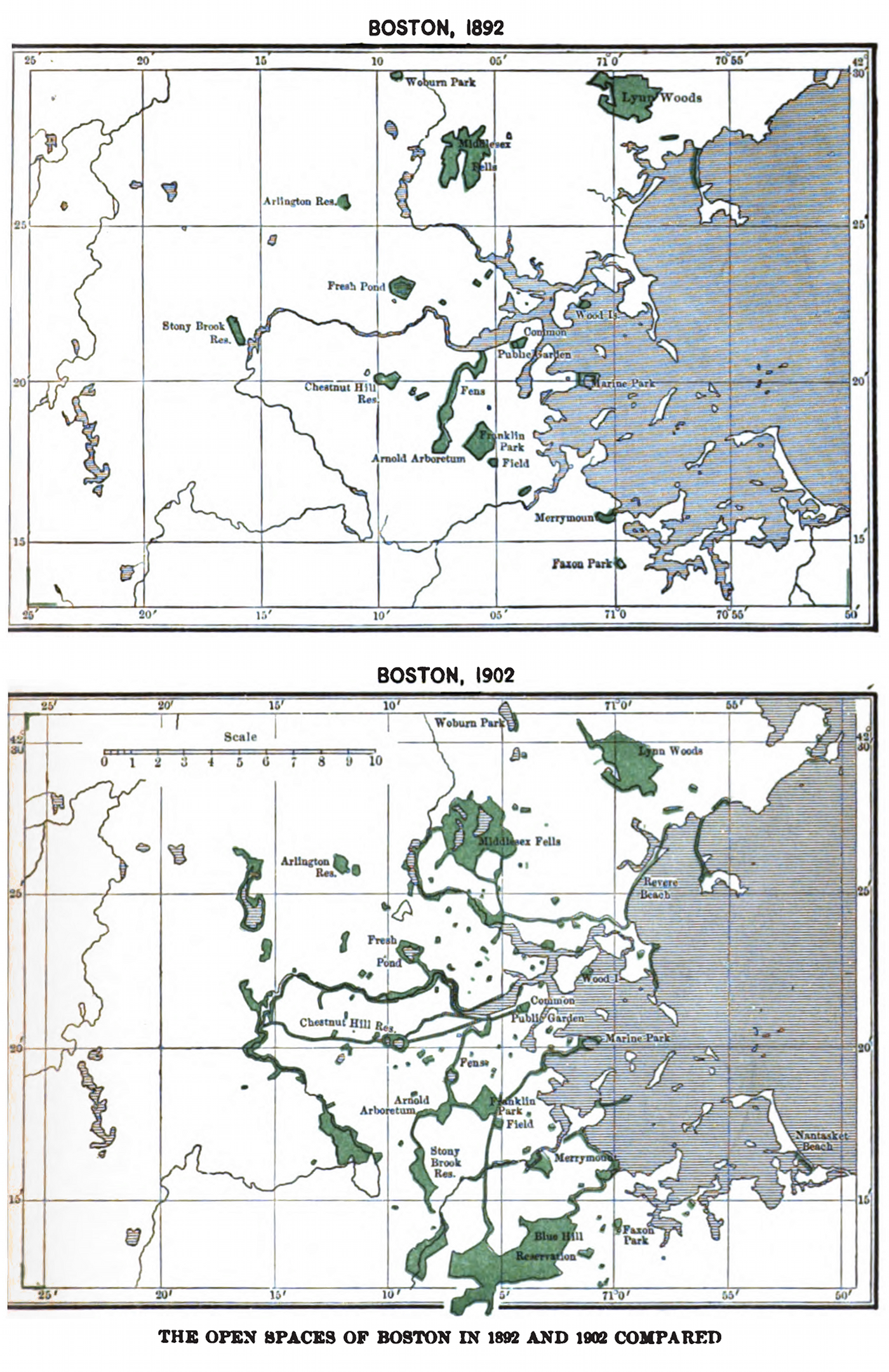
 The open spaces of Boston in 1892 and 1902 compared in an illustration from a biography of Charles Eliot
- ^ a b c "DCR: Division of Urban Parks and Recreation". Commonwealth of Massachusetts. http://www.mass.gov/dcr/metroboston.htm. Retrieved 8 December 2009.
- ^ a b c "Division of Urban Parks and Recreation History". Commonwealth of Massachusetts. http://www.mass.gov/dcr/uphistory.htm. Retrieved 8 December 2009.
- ^ "Planning and Engineering". Commonwealth of Massachusetts. http://www.mass.gov/dcr/planning.htm. Retrieved 8 December 2009.
- ^ Report of the Board of Metropolitan Park Commissioners. January, 1893.. Boston: Wright & Potter Printing Co. (no imprint). c.1893. pp. 16–19,31,88–89,91,108–109.
- ^ a b c Eliot, Charles William (1902). Charles Eliot, landscape architect. Cambridge, MA: Houghton, Mifflin. http://books.google.com/books?id=MloAAAAAYAAJ&pg=PA738#v=twopage&q=&f=false. Retrieved 2009-12-08.
- ^ Board of Paris Exposition Managers, Massachusetts Board of Metropolitan Park Commissioners, ed (1900). A History and Description of the Boston metropolitan parks. Boston: Wright & Potter Printing Co.. p. 32. OCLC 16896572. http://books.google.com/books?id=n9IUAAAAYAAJ&pg=RA1-PA32. Retrieved 2010-01-01.
- ^ Report of the Board of Metropolitan Park Commissioners, December 1916.. Boston: Wright & Potter Printing Co.. 1917. p. 9. http://books.google.com/books?id=6CtJAAAAMAAJ&pg=PA9. Retrieved 2009-12-13.
- ^ Board of Paris Exposition Managers, Massachusetts Board of Metropolitan Park Commissioners, ed (1900). A History and Description of the Boston metropolitan parks. Boston: Wright & Potter Printing Co.. p. 34. OCLC 16896572. http://books.google.com/books?id=n9IUAAAAYAAJ&pg=RA1-PA32. Retrieved 2010-01-01.
- ^ a b c Leccese, Mark (2003). "Enhancing Regional Greenfrastructure". Rappaport Institute for Greater Boston/Harvard University. http://www.hks.harvard.edu/rappaport/downloads/metroparks_greenfrastructure.PDF. Retrieved 11 January 2010.
- ^ Dolin, Eric Jay (2004). Political waters: the long, dirty, contentious, incredibly expensive but eventually triumphant history of Boston Harbor--a unique environmental success story. Amherst, Massachusetts: University of Massachusetts Press. ISBN 9781558494459. http://books.google.com/books?id=G6rcthRoifcC. Retrieved 2010-01-11.
- ^ Mazzone, Hon. A. David. "Mazzone, Judge A. David : Chamber Papers on the Boston Harbor Clean Up Case, 1985-2005". http://www.lib.umb.edu/node/1620. Retrieved 2009-06-11.
- ^ "Mass Moments: Massachusetts Creates Nation’s First Regional Park System". Massachusetts Foundation for the Humanities. http://www.massmoments.org/moment.cfm?mid=164. Retrieved 11 January 2010.
- ^ "Watershed Supply Protection Trust". Commonwealth of Massachusetts. http://www.mass.gov/dcr/waterSupply/watershed/trust.htm. Retrieved 11 January 2010.
- ^ "Chapter 25 of the Acts of 2009 (Section 177)". The 186th General Court of The Commonwealth of Massachusetts. http://www.mass.gov/legis/laws/seslaw09/sl090025.htm. Retrieved 2009-11-05.
- ^ Pazzanese, Christina (September 12, 2009). "A big concern on two major parkways". The Boston Globe. http://www.boston.com/news/local/massachusetts/articles/2009/09/12/a_big_concern_on_two_major_parkways/. Retrieved 2009-11-05.
- ^ Areas, years formed and municipalities are listed on DCR web pages for some, but not all, parks. Where the DCR page contains unclear information, the data is either from a cited source or from the Office of Geographic and Environmental Information (MassGIS), Commonwealth of Massachusetts Executive Office of Environmental Affairs "Protected and Recreational Open Space" datalayer. Area figures from the datalayer may represent a larger space than is accessible to the public, due to the inclusion of administrative or undeveloped sections of a given park.
- ^ "Friends of Belle Isle Marsh". http://www.friendsofbelleislemarsh.org/. Retrieved 8 January 2010.
- ^ "Boston Harbor Islands State Park". Arnoldia (Boston: President and Trustees of Harvard College) 48 (3): 21–22. 1988. http://arnoldia.arboretum.harvard.edu/pdf/articles/742.pdf. Retrieved 2010-01-10.
- ^ "The Boston Harborwalk: Learn about history". The Boston Harbor Association. http://www.bostonharborwalk.com/thingstodo/?aid=5. Retrieved 10 January 2010.
- ^ "Boston Harbor Islands State Park". Arnoldia (Boston: President and Trustees of Harvard College) 48 (3): 14. 1988. http://arnoldia.arboretum.harvard.edu/pdf/articles/740.pdf. Retrieved 2010-01-10.
- ^ "Healthy Communities Grant Program 2007". Town of Hull. p. 26. http://www.town.hull.ma.us/Public_Documents/HullMA_SustainComm/HealthyCommGrant.pdf. Retrieved 11 January 2010.
- ^ Adams, Charles Francis (1896). Report of the Board of Metropolitan Park Commissioners. BiblioBazaar, LLC. ISBN 9780554555096. http://books.google.com/books?id=ALbRrk3fZsoC&pg=PA14&lpg=PA14&. Retrieved 2010-01-11. (King's Beach acquired)
- ^ City charter, chapter 283, acts of 1897, ordinances of 1898, standing regulations, statutes relating to the city. Newton, MA: City of Newton. http://books.google.com/books?id=sRwbAAAAYAAJ&pg=PA242. Retrieved 2010-01-11.
- ^ "Wollaston Beach". City of Quincy. http://www.quincyma.gov/Government/PARK/WollastonBeach.cfm. Retrieved 11 December 2009.
- ^ "Rumney Marsh". http://www.reverebeach.com/rumneymarsh/history1.html. Retrieved 11 January 2010.[dead link]
- ^ "Island Facts: Webb Memorial State Park". United States Department of the Interior, National Park Service. http://www.nps.gov/boha/historyculture/facts-webb.htm. Retrieved 11 January 2010.
- ^ "Stodder's Neck/Abigail Adams Park". Commonwealth of Massachusetts. http://www.mass.gov/dcr/parks/metroboston/weymouth.htm. Retrieved 13 December 2009. (Land acquired for Abigail Adams State Park, added to Stodder's Neck to form reservation)
- ^ Private and special statutes of the Commonwealth of Massachusetts, Volume 20. Boston: Commonwealth of Massachusetts. 1909. pp. 293. http://books.google.com/books?id=0iwWAAAAYAAJ&pg=PA293. Retrieved 2010-01-11.
- ^ a b "Chestnut Hill Reservation: Resource Management Plan". Commonwealth of Massachusetts. http://www.mass.gov/dcr/stewardship/rmp/rmp-chHill.htm. Retrieved 10 January 2010.
- ^ "Annual Report". Commonwealth of Massachusetts, Office of the Inspector General. 1996. pp. 17. http://www.mass.gov/ig/publ/annrpt96.pdf. Retrieved 11 January 2010.
- ^ "Hemlock Gorge". Newton Conservators. http://www.newtonconservators.org/21hemlock.htm. Retrieved 11 November 2010.
- ^ "National Register Information System". National Register of Historic Places. National Park Service. 2008-04-15. http://nrhp.focus.nps.gov/natreg/docs/All_Data.html. (Parkway construction begun)
- ^ "History". Friends of the Fells. http://www.fells.org/thefells/history.cfm. Retrieved 9 January 2010.
- ^ Walsh, Patrick J. (December 13, 2009). "Of granite, plugs, and feathers". The Boston Globe. http://www.boston.com/news/local/articles/2009/12/13/of_granite_plugs_and_feathers/?page=2. Retrieved 11 January 2010.
Metropolitan Park System of Greater Boston Coastal reservations Belle Isle Marsh • Boston Harbor Islands • Castle Island • Dorchester Shores • Fort Revere Park • Lynn Shore • Nahant Beach • Nantasket Beach • Quincy Shore • Revere Beach • Rumney Marsh • Webb Memorial State Park • Weymouth Back RiverRiver reservations Alewife Brook • Charles River • Chestnut Hill • Cutler Park • Elm Bank • Hemlock Gorge • Mystic River • Neponset River • Pope John Paul II Park • Squantum Point Park • Upper Charles RiverWoodland reservations Beaver Brook • Blue Hills • Breakheart • Hammond Pond • Middlesex Fells • Quincy Quarries • Southwest Corridor Park • Stony Brook • Wilson MountainHeritage state parks Lynn Heritage State Park • Roxbury Heritage State ParkParkways and roads Alewife Brook Parkway · Arborway · Blue Hills Parkway · Blue Hills Reservation Parkways · Charles River Reservation Parkways · Day Boulevard · Fells Connector Parkways · Fenway · Fresh Pond Parkway · Furnace Brook Parkway · Hammond Pond Parkway · Hull Shore Drive · Jamaicaway · Lynn Fells Parkway · Memorial Drive · Morrissey Boulevard · Mystic Valley Parkway · Nahant Beach Boulevard · Nantasket Avenue · Park Drive · Quincy Shore Drive · Revere Beach Parkway · Riverway · Soldiers Field Road · Stony Brook Reservation Parkways · Storrow Drive · Truman Parkway · VFW Parkway · West Roxbury Parkway • Winthrop Parkway • Winthrop Shore DriveDepartment of Conservation and Recreation • Greater Boston • List of Massachusetts State Parks Categories:- Massachusetts state parks
Wikimedia Foundation. 2010.