Nantasket Beach

Nantasket Beach
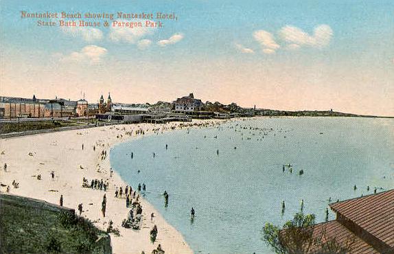
Nantasket Beach circa 1910

Nantasket Beach is a beach in Hull, Massachusetts. The shore has fine, light gray sand and is one of the busiest beaches in Greater Boston. At low tide, there are acres of tide pools.

Name

The name "Nantasket" is derived from Wampanoag and means "at the strait" or "low-tide place." Nantasket was settled not long after Plymouth Colony and before Mass Bay. Roger Conant (Salem) was in the area, after leaving the Plymouth Colony and before going to Cape Ann in 1625. Until Hull was incorporated in 1644, English settlers referred to the whole local region as "Nantasket Peninsula."

History

In 1825 Paul Warrick established "The Sportsman Hotel" on Nantasket Avenue. Later, more hotels were built and steamboats made three trips a day between here and Boston in the 1840s Later, an amusement area called Paragon Park was built adjacent to the beach. This was closed in 1984.

External links

Nantasket Beach Resort


Coordinates: 42°16′13″N 70°51′17″W / 42.27028°N 70.85472°W / 42.27028; -70.85472


Wikimedia Foundation. 2010.

Игры ⚽ Нужен реферат?

Look at other dictionaries:

  • Nantasket Beach Resort — (Халл,США) Категория отеля: 3 звездочный отель Адрес: 45 Hull Shore Drive, Халл, MA …   Каталог отелей

  • Nantasket Hotel at the Beach — (Халл,США) Категория отеля: 3 звездочный отель Адрес: 115 Nantasket Avenu …   Каталог отелей

  • Hull Shore Drive and Nantasket Avenue — Hull Shore Drive, Nantasket Avenue, Metropolitan Park System of Greater Boston MPS U.S. National Register of Historic Places U.S. Historic district …   Wikipedia

  • Nahant Beach Reservation — Coordinates: 42°26′52″N 70°56′20″W / 42.44778°N 70.93889°W / 42.44778; 70.93889 …   Wikipedia

  • Nahant Beach Boulevard — Metropolitan Park System of Greater Boston U.S. National Register of Historic Places U.S. Historic district …   Wikipedia

  • Crane Beach — Not to be confused with Crane Beach, Barbados. Panorama of Crane Beach in September 2007 Crane Beach is a 1,234 acre (4.99 km2) conservation and recreation property located in Ipswich, Massachusetts, immediately north of Cape Ann. It… …   Wikipedia

  • Hull, Massachusetts — Infobox Settlement official name = Hull, Massachusetts nickname = motto = imagesize = 250px image caption = Aerial view of Hull image mapsize = 250px map caption = Location in Plymouth County in Massachusetts mapsize1 = map caption1 = subdivision …   Wikipedia

  • Metropolitan Park System of Greater Boston — Pedestrian bridge, Charles River Esplanade, Boston, Massachusetts …   Wikipedia

  • Old Colony Railroad — This article is about the large railroad system in southeastern Massachusetts. For the earlier Old Colony Railroad , see New Bedford and Taunton Railroad. Old Colony Railroad O.C.R.R. s Boston Kneeland Street Depot …   Wikipedia

  • List of Massachusetts railroads — Contents 1 Common freight carriers 2 Passenger carriers 3 Defunct railroads …   Wikipedia

Share the article and excerpts

Direct link
Do a right-click on the link above
and select “Copy Link”