- Roxbury Heritage State Park
-
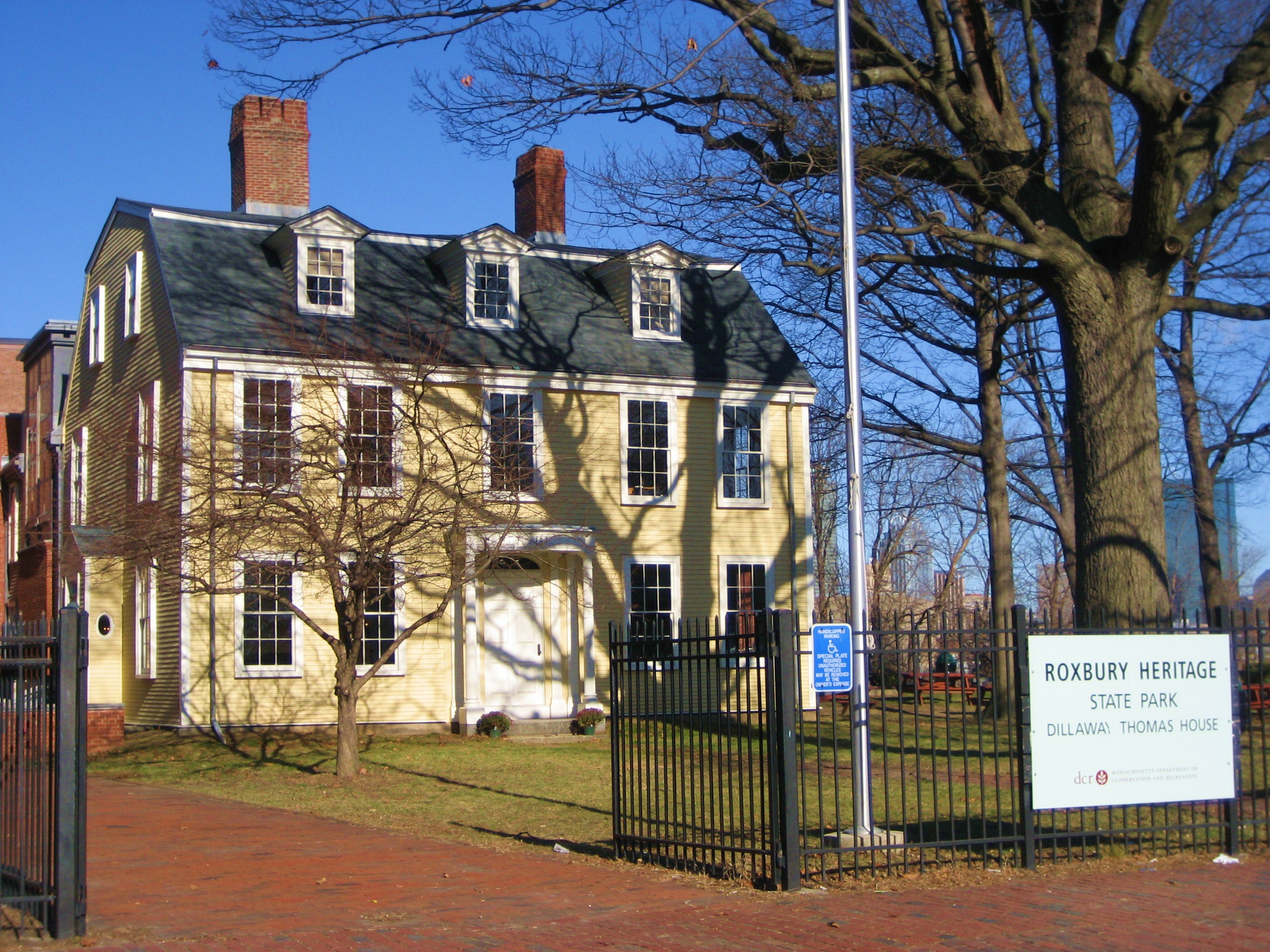
Roxbury Heritage State Park Metropolitan Park System of Greater Boston 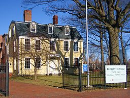 Dillaway-Thomas House
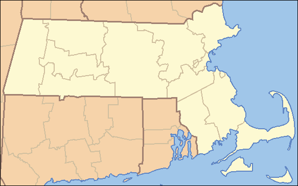
Country United States State Massachusetts Region Suffolk County Municipality Boston Location 183 Roxbury Street - coordinates 42°19′49″N 71°5′26″W / 42.33028°N 71.09056°W Area 2.146 acres (1 ha) [1] (nine parcels) Founded 1992 Management Massachusetts Department of Conservation and Recreation 
 Location of Roxbury Heritage State Park
Website: http://www.mass.gov/dcr/parks/metroboston/rxhp.htm Roxbury Heritage State Park is a history-themed heritage park in the oldest part of Roxbury, a former town annexed in 1868 by Boston, Massachusetts.[2][3] It is anchored by the Dillaway–Thomas House, a large colonial structure built in 1750 and thought to be the oldest surviving house in Roxbury.[4][5] The location includes an adjacent 1-acre (0.40 ha) landscaped park with views of the Boston skyline,[1][4] and is part of the Metropolitan Park System of Greater Boston.
Background
The heritage park is located in the John Eliot Square area of northern Roxbury, which was the site of the town center after its founding in 1630.[2] The Georgian-style home was built as a parsonage for Rev. Oliver Peabody, pastor of the First Church of Roxbury in 1750.[6] The house was later owned by Martha Dillaway and then John Thomas, an American commander in the Continental Army during the American Revolutionary War.[6] While Thomas owned the house in 1776, cannons from Fort Ticonderoga in New York were transported by Henry Knox to Cambridge, Massachusetts and then through Roxbury on the way to forming the Fortification of Dorchester Heights, where they were used to force the evacuation of the British from Boston on March 17.[7] A marker commemorating the neighborhood as a stop on the Knox trail and signifying Thomas' role in ending the Siege of Boston was placed at the park in 2009.[8] The marker was the 57th placed to commemorate the Knox Expedition, and the first added since the string of monuments marking the trail was established in 1927.[9][10]
The house was first restored in the 1930s by a preservationist who also introduced some inaccurate fixtures in an effort to embellish its history.[5] After two fires in the 1970s, a state representative who was a former Roxbury resident successfully petitioned the legislature in 1984 for funding to restore the house and preserve it as a heritage park.[6] The following restoration was done leaving some spots showing levels of all previous work done to the house left exposed, creating a physical timeline of the architectural history of the house.[5] The completed house was opened to the public in 1992, and contains exhibits tracing periods of the history of Roxbury from the past to the present.[6][4]
References
- ^ a b Protected and recreational open space datalayer, Office of Geographic and Environmental Information (MassGIS), Commonwealth of Massachusetts Executive Office of Environmental Affairs - http://www.mass.gov/mgis/dd-over.htm
- ^ a b "Roxbury's History". Boston Landmarks Commission. 1995. http://www.discoverroxbury.org/#/roxburys-history/4528136328. Retrieved 15 December 2009.
- ^ "Boston's Neighborhoods". Boston Redevelopment Authority. http://www.bostonredevelopmentauthority.org/neighborhoods/Neighborhoods.asp?action=ViewHood&HoodID=16. Retrieved 15 December 2009.
- ^ a b c "Roxbury Heritage State Park". Commonwealth of Massachusetts. http://www.mass.gov/dcr/parks/metroboston/rxhp.htm. Retrieved 13 December 2009.
- ^ a b c Campbell, Robert (May 20, 1993). "A window on the past". The Boston Globe.
- ^ a b c d Coleman, Sandy (October 11, 1992). "Roxbury house reopens to tell of past, future". The Boston Globe.
- ^ "Celebrating the Knox Trail". Evacuation Day Heritage Committee. 2008. http://www.evacuationday.com/images/Evacuation_Day_3_15_08_Final_Draft.pdf. Retrieved 15 December 2009.
- ^ "The Knox Museum joins Evacuation Day celebration". General Henry Knox Museum. Spring 2009. http://www.generalknoxmuseum.org/images/Spring09Newsletter.pdf. Retrieved 15 December 2009.
- ^ Miller, Yawu (March 19, 2009). "Roxbury role in Revolutionary War recognized with marker". Boston: Bay State Banner. http://www.baystatebanner.com/local16-2009-03-19. Retrieved 15 December 2009.
- ^ "Marking history: new Roxbury Knox Trail marker". Evacuation Day Heritage Committee. http://www.evacuationday.com/citywideevents.html. Retrieved 15 December 2009.
Metropolitan Park System of Greater Boston Coastal reservations Belle Isle Marsh • Boston Harbor Islands • Castle Island • Dorchester Shores • Fort Revere Park • Lynn Shore • Nahant Beach • Nantasket Beach • Quincy Shore • Revere Beach • Rumney Marsh • Webb Memorial State Park • Weymouth Back RiverRiver reservations Alewife Brook • Charles River • Chestnut Hill • Cutler Park • Elm Bank • Hemlock Gorge • Mystic River • Neponset River • Pope John Paul II Park • Squantum Point Park • Upper Charles RiverWoodland reservations Beaver Brook • Blue Hills • Breakheart • Hammond Pond • Middlesex Fells • Quincy Quarries • Southwest Corridor Park • Stony Brook • Wilson MountainHeritage state parks Lynn Heritage State Park • Roxbury Heritage State ParkParkways and roads Alewife Brook Parkway · Arborway · Blue Hills Parkway · Blue Hills Reservation Parkways · Charles River Reservation Parkways · Day Boulevard · Fells Connector Parkways · Fenway · Fresh Pond Parkway · Furnace Brook Parkway · Hammond Pond Parkway · Hull Shore Drive · Jamaicaway · Lynn Fells Parkway · Memorial Drive · Morrissey Boulevard · Mystic Valley Parkway · Nahant Beach Boulevard · Nantasket Avenue · Park Drive · Quincy Shore Drive · Revere Beach Parkway · Riverway · Soldiers Field Road · Stony Brook Reservation Parkways · Storrow Drive · Truman Parkway · VFW Parkway · West Roxbury Parkway • Winthrop Parkway • Winthrop Shore DriveProtected Areas of Massachusetts Federal Adams · Boston · Boston African American · Frederick Law Olmsted · John Fitzgerald Kennedy · Longfellow House · Lowell · Minute Man · New Bedford Whaling · Salem Maritime · Saugus Iron Works · Springfield Armory
Appalachian National Scenic Trail · Boston Harbor Islands National Recreation Area · Cape Cod National Seashore · Stellwagen Bank National Marine Sanctuary · Waquoit Bay National Estuarine Research Reserve · West Hill Dam
Assabet River · Great Meadows · Mashpee · Massasoit · Monomoy · Nantucket · Nomans Land · Oxbow · Parker River · Silvio O. Conte · Thacher Island
State Alewife Brook · Ames Nowell · Ashland · Bash Bish Falls · Blackstone River and Canal Heritage · Borderland · Boston Harbor Islands · Bradley Palmer · C. M. Gardner · Callahan · Castle Island State Park · Chicopee Memorial · City Square · Clarksburg · Cochituate · Connecticut River Greenway · Demarest Lloyd · Dighton Rock · Dunn · Ellisville Harbor · Fall River Heritage · Gardner Heritage · Great Brook Farm · Halibut Point · Hampton Ponds · Holyoke Heritage · Hopkinton · Lake Lorraine · Lake Wyola · Lawrence Heritage · Lowell Heritage · Lynn Heritage · Massasoit · Maudslay · Moore · Mount Holyoke Range · Natural Bridge · Nickerson · Pearl Hill · Pilgrim · Quinsigamond · Robinson · Roxbury Heritage · Rutland · Skinner · South Cape Beach · Wahconah Falls · Webb Memorial · Wells · Western Gateway Heritage · Whitehall · Wompatuck
State Parks:
ReservationsBeaver Brook · Belle Isle Marsh · Blue Hills · Breakheart · Charles River · Chestnut Hill · Cutler · Dorchester Shores · Elm Bank · Fort Phoenix · Hammond Pond · Hemlock Gorge · Horseneck Beach · Jug End · Lynn Shore · Middlesex Fells · Mount Everett · Mount Greylock · Mount Sugarloaf · Mount Tom · Myles Standish · Mystic River · Nahant Beach · Nantasket Beach · Nasketucket Bay · Neponset River · Pope John Paul II · Purgatory Chasm · Quincy Quarries · Quincy Shore · Revere Beach · Rumney Marsh · Salisbury Beach · Sandy Point · Scusset Beach · Stony Brook · Upper Charles River · Wachusett Mountain · Walden Pond · Weymouth · Wilson Mountain
State Parks:
OtherAppalachian Trail · Ashuwillticook Rail Trail · Cape Cod Rail Trail · Fort Revere · Lake Dennison Recreation Area · Lower Neponset River Trail · Nashua River Rail Trail · Norwottuck Rail Trail · Quabbin Reservoir · Southwest Corridor Park · Squantum Point Park · Streeter Point Recreation Area · Sudbury Reservoir · Wachusett Reservoir · Ware River Watershed Area
Barnstable · Beartown · Brimfield · Chester-Blandford · DAR · Douglas · Erving · F. Gilbert Hills · Federated Women's Club · Freetown-Fall River · Georgetown Rowley · Granville · Harold Parker · Kenneth Dubuque Memorial · Leominster · Lowell-Dracut-Tyngsboro · Manuel F. Correllus · Mohawk Trail · Monroe · Mount Grace · Mount Washington · Myles Standish · October Mountain · Otter River · Pittsfield · Sandisfield · Savoy Mountain · Shawme-Crowell · Spencer · Tolland · Upton · Wendell · Willard Brook · Willowdale · Windsor
Agawam Lake · Agawam Mill Pond · Ashby · Ashfield Hawley · Attitash · Ayer Game Farm · Baddacook Pond · Bakers Pond · Bay Circuit Trail · Bearse Pond · Becket · Bennett · Birch Hill · Black Brook · Blackstone / West River · Bolton Flats · Boxboro Station · Brayton Point Salt Marsh · Breakneck Brook · Brewer Brook · Bullock Ledge · Burrage Pond · Canoe River · Catamount · Chalet · Chase Garden Creek Salt Marsh · Childs River · Chockalog Swamp · Church Homestead · Clapps Pond · Clinton Bluff · Concord River · Connecticut River · Cook Pond · Copicut · Coy Hill · Crane Pond · Cummington · Cusky Pond · Dartmoor Farm · Darwin Scott Memorial · Day Mountain · Deerfield River · Dogfish Bar Beach Coastal · Dolomite Ledges · Dunstable Brook · E. Kent Swift · Eagle Island · East Mountain · Eastham Salt Marsh · Elbow Meadow · English Salt Marsh · Eugene D. Moran · Facing Rock · Fairfield Brook · Farmington River · Fish Brook · Fisherville Pond · Fisk Forestdale Lot · Fisk Meadows · Five Mile River · Flagg Swamp · Flint Pond · Four Chimneys · Fox Den · Fox Island Salt Marsh · Frances A. Crane · Freetown Swamp · George L. Darey Housatonic Valley · Glen Echo Lake · Gosnold · Grassy Pond (Dennis) · Grassy Pond (Plymouth) · Green River (Franklin County) · Green River (Berkshire County) · Greenfield River · Halfway Pond · Hamilton · Hancock · Harlow / Cooks Pond · Haskell Swamp · Hauk Swamp · Hawksnest State Park · Hawley · Head Of The Plains · Herman Covey · High Ridge · Hinsdale Flats · Hiram H. Fox · Hockomock Swamp · Hog Pond Lot · Honey Pot · Hoosatonic River · Hoosic River · Hop Brook · Housatonic River · Hubbard Brook · Hunting Hills · Hyannis Ponds · Ipswich River · John J. Kelly · Jug End Fen · Jug End · Kampoosa Fen · Katama Plains · Knops Pond · Konkapot River · Lackey Pond · Lake Lorraine · Lake Rohunta · Lake Snipatuit · Lake Warner · Lanesboro · Lawrence Brook · Lawrence Pond Lot · Leadmine · Leyden · Lilly Pond · Little Alum Pond · Long Sought For Pond · Maple Hill · Maple Springs · Martha Deering · Martin H. Burns · Mascuppic Lake · Mashpee Pine Barrens · Mashpee Pond Lot · Mashpee River · Massachusetts Military Reservation · Mckinstry Brook · Meetinghouse Swamp · Merrill Pond · Miacomet Heath · Mill River · Millers River · Mine Brook · Montague Plains · Montague · Moose Brook · Moose Brook · Moose Hill · Mossy Pond · Mount Watatic Reservation · Mt. Esther · Mt. Toby Highlands · Mt. Toby · Mt. Tom · Muddy Brook · Muddy Pond · Mulpus Brook · Nashua River · Natty Brook · Nemasket River · Nissitissit River · Noquochoke · Nordeen Marsh · North Brookfield · North Shore Salt Marsh · Northboro · Oakham · Olivers Pond · Orange · Otis · Packard Pond · Palmer · Pantry Brook · Pauchaug Brook · Peru · Peterson Swamp · Phillipston · Podunk Marsh · Poland Brook · Popple Camp · Popponesset Beach · Poutwater Pond · Powell Brook · Prince River · Provincetown Route 6 Corridor · Purchade Brook · Quaboag · Quacumquasit · Quag Pond Bog · Quashnet River · Quashnet Woods State Reservation · Quinapoxet River · Quinsigamond Marsh · Quisset · Raccoon Hill · Rainbow Beach · Red Brook · Richardson · Robbins Pond · Rochester · Rocky Gutter · Rowe · Salisbury Salt Marsh · Salisbury Salt Marsh · Sandwich Game Farm · Sandy Pond · Satan's Kingdom · Savage Hill · Savoy · Sawmill River · Scorton Creek Coastal · SE Mass Bioreserve · Sevenmile River · Shattuck Brook · Sheperds Island · Shubael Pond · Sibley Brook · Sly Pond · South Barrier Beach · South Meadow Pond · South Shore Salt Marsh · South Triangle Pond · Southampton · Southwick · Spectacle Pond · Springhill Lot · Sputtermill Pond · Squannacook River · Stafford Hill · Sudbury River · Sunderland Islands · Taconic Mountain · Taunton River · Taunton River · Tekoa Mountain · Thad Ellis · Thayer Pond · Three Mile Pond · Townsend · Townsend Hill · Trapfall Brook · Triangle Pond · Tully Brook · Tully Mountain · Tully River · Wakeby Pond · Wales · Walnut Hill · Ware River · Warwick · Wendell · West Meadows · Westboro · Westfield River · Westfield · Weymouth Back River · Whately Great Swamp · Whately Ponds · Whately · Wilbraham Game Farm · William Forward · Williams River · Williamsburg · Winimusset · Wolf Swamp ·Billingsgate Island · Carr Island · E. Howe Forbush · Egg Rock · Grace A. Robson · J.C. Phillips · Knight · Penikese Island · Ram Island (Salisbury) · Ram Island (Mattapoisett) · Susan B. Minns · Tarpaulin Cove · Watatic Mountain ·Private Roger and Virginia Drury Preserve · Tatkon Preserve · McElwain-Olsen Preserve · Reed Brook Preserve · Hawley Bog Preserve · Stacy Mountain Preserve · Greene Swamp Preserve · Black Pond Bog Nature Preserve · Halfway Pond Island Preserve · Grassy Pond Preserve · Boat Meadow Preserve · Sandy Neck Preserve · Hockomock Swamp · David H. Smith Preserve and Fire Trail · Hoft Farm Preserve · Katama Plains Preserve · Francis Newhall Woods Nature and Wildlife Preserve · Miacomet Moors Preserve · Homer-Watcha Preserve ·
Agassiz Rock · Appleton Farms · Appleton Farms Grass Rides · Ashintully Gardens · Bartholomew's Cobble · Bear's Den · Bear Swamp · Colonel John Ashley House · Francis William Bird Park · Eleanor Cabot Bradley Estate · Bridge Island Meadows · Brooks Woodland Preserve · William Cullen Bryant Homestead · Cape Poge Wildlife Refuge · Cedariver · Castle Hill · Chapel Brook · Charles River Peninsula · Chase Woodlands · Chesterfield Gorge · Coolidge Reservation · Copicut Woods · Cormier Woods · Coskata-Coatue Wildlife Refuge · Crane Beach · Crane Wildlife Refuge · Crowninshield Island · Dexter Drumlin · Dinosaur Footprints · Doane's Falls · Doyle Reservation · Dry Hill · East Over Reservation · Elliott Laurel · Field Farm · Fork Factory Brook · Glendale Falls · Goose Pond Reservation · Greenwood Farm · Halibut Point Reservation · Hamlin Reservation · Holmes Reservation · Governor Hutchinson's Field · Jacobs Hill · Little Tom Mountain · Long Hill · Long Point Wildlife Refuge · Lowell Holly Reservation · Lyman Reserve · Malcolm Preserve · Mashpee River Reservation · McLennan Reservation · Medfield Meadow Lots · Medfield Rhododendrons · Menemsha Hills · Misery Islands · Mission House · Monument Mountain · Moose Hill Farm · Mount Ann Park · Mountain Meadow Preserve · Mytoi · Naumkeag · Noanet Woodlands · Noon Hill · Norris Reservation · North Common Meadow · Norton Point Beach · Notchview · Old Manse · Old Town Hill · Peaked Mountain · Pegan Hill · Peters Reservation · Petticoat Hill · Pierce Reservation · Pine and Hemlock Knoll · Powisset Farm · Questing · Quinebaug Woods · Ravenswood Park · Redemption Rock · Rock House Reservation · Rocky Narrows · Rocky Woods · Royalston Falls · Shattuck Reservation · Signal Hill · Slocum's River Reserve · Stavros Reservation · The Stevens-Coolidge Place · Swift River Reservation · Tantiusques · Tully Lake Campground · Two Mile Farm · Tyringham Cobble · Ward Reservation · Wasque · Weir Hill · Weir River Farm · Westport Town Farm · Whitney and Thayer Woods · World's End ·
Arcadia · Broad Meadow Brook · Broadmoor · Drumlin Farm · High Ledges · Ipswich River · North River · Pleasant Valley · Stony Brook · Wachussett Meadow · Wellfleet Bay
OtherConcord Land Conservation Trust · Harvard Forest · Lincoln Land Conservation Trust ·
Categories:- Parks in Boston, Massachusetts
- Massachusetts state parks
- History museums in Massachusetts
- Museums in Boston, Massachusetts
- Houses in Boston, Massachusetts
Wikimedia Foundation. 2010.