- Maudslay State Park
-
For other uses, see Maudslay (disambiguation).
Maudslay State Park Massachusetts State Park 
 Location of Maudslay State Park in Massachusetts
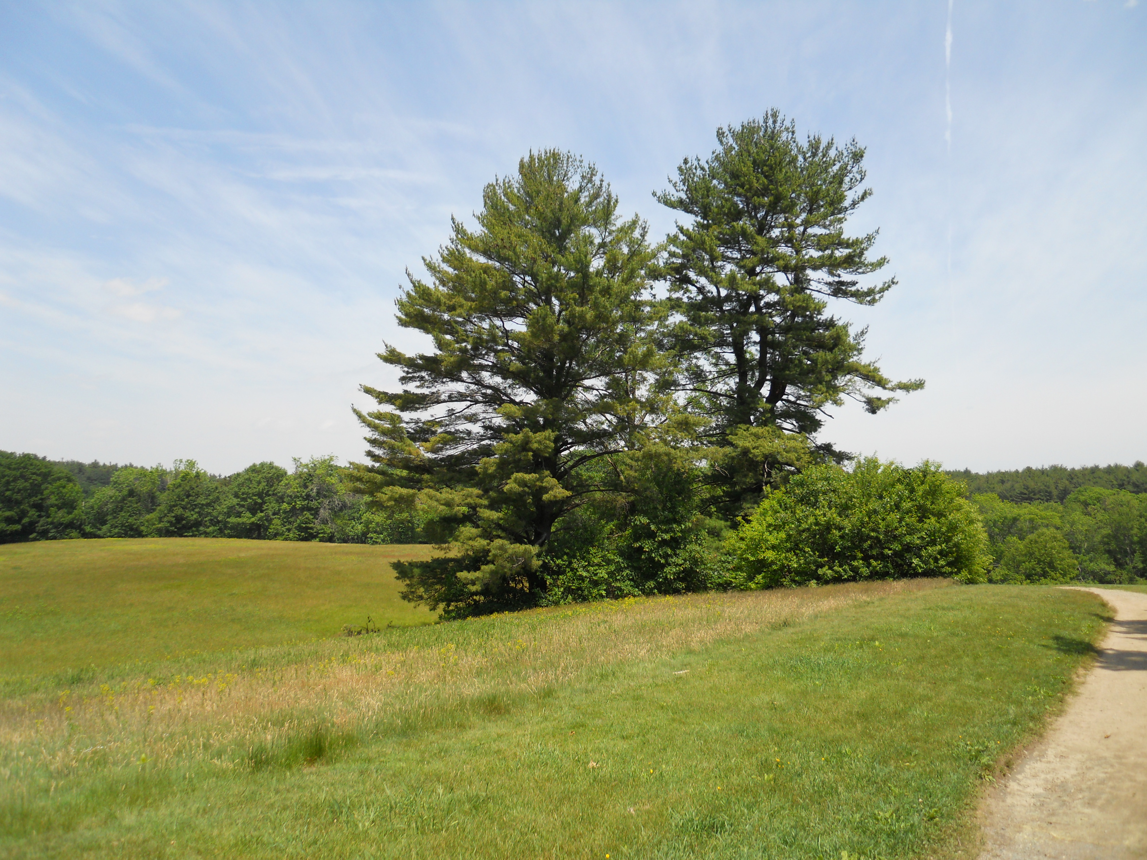
Country United States State Massachusetts County Essex City Newburyport, Massachusetts Location - coordinates 42°49′16″N 70°55′29″W / 42.82111°N 70.92472°WCoordinates: 42°49′16″N 70°55′29″W / 42.82111°N 70.92472°W Area 450 acres (182 ha) Founded 1985 Managed by Department of Conservation and Recreation (Massachusetts)  Pinus strobus standing free in a meadow at Maudslay.
Website : Maudslay State Park Maudslay State Park is a Massachusetts state park located in Newburyport. The park is managed by the Department of Conservation and Recreation. It is available (by permit) for weddings and other programs.
Contents
Description
Maudslay State Park is a landscaped and decorative park along the right bank of the Merrimack River. It features thickets and gardens, rolling meadows, tall pines, and one of the largest naturally occurring stands of mountain laurel in the Commonwealth. Within the park, visitors can also find numerous ornamental trees, such as azaleas, and rhododendrons.
The park is bordered on the west side by the Artichoke River, which is also the border between Newburyport and West Newbury. Curzon Mill, not currently used as a mill, and neighboring houses at the mouth of the Artichoke, where it flows into the Merrimack, remain in private hands. The bridge over the Artichoke is closed.
The pines and the eagles
The most striking natural feature of the park is the primeval stands of white pine on the steep slopes and bluffs of the river, which appear never to have been logged. The laurel forms a continuous thicket along the forest floor around the pines, which are so tall that their tops are not visible in the upper canopy from below. The canopy is a nesting site for bald eagles, who from time to time disrupt traffic by perching in isolated pines hanging over the river outside of the park. The stands are found also in the few ravines that lace the park.
The river
The park covers approximately 450 acres (180 ha) of the right bank of the Merrimack River, a tidal estuary at its lower end. The main channel of the estuary runs beneath the bluffs of the park. The channel is navigable to small craft and is marked by buoys. The swift currents and high bacteria counts render the waters useless for swimming or bathing, as well as adding an element of danger to the careless boater. Seasonal floods often sweep away the docks, damage the bridges, flood the homes and wash out low-lying roads on the riverbank. Despite these dangers the lower river is home to a substantial industry of facilities for docking, storing and repairing recreational boats.
The return of the eagles to their former habitat is related to the return of their food supply. By 1950 the Merrimack River was for the most part devoid of marine and riverine life, due to chemical effluents from the cloth and paper mills upstream in Haverhill, Lawrence, Lowell, Manchester, New Hampshire and Concord, New Hampshire as well as the dumping of raw sewage into the river from every community on it. Since then the industry has moved south, sewage is better treated and environmental laws have gone into effect and have been to some degree enforced in every community. Dams upstream prevent the return of migratory piscines but maritime life on the lower river has improved to the point of supporting a new population of eagles.
Upper woods
Colonial Newburyport lacked the bridges that currently link Newburyport with Salisbury and Amesbury on the left bank of the river. Newbury, West Newbury and Newburyport were originally the same parcel of land, settled in 1635 by an English party, which landed on the left bank of a river later (1697) renamed the Parker River, after the settlement's spiritual counselor, Rev. Parker. Before long the pine woods on the ridge of the right bank of the Merrimack had been cleared in favor of homesteads. "Country Lane" (High Street) led from Newbury to Bradford Road (Storey Street). The remaining forest between Bradford Road and the river was called the "Upper Woods", of which a small fragment hosts the eagles today.
In 1641 the General Court of Massachusetts appointed George Carr official ferryman of the ferry he had started between Carr's and Ram Islands in the Merrimack to Colchester, settled in 1639 (shortly after renamed to Salisbury), which included today's Amesbury. Poore's Lane (Woodland Street) connected Country Lane to the ferry. A similar ferry crossed the Parker. The settlers were concerned with getting the links of the original coastal road, now Route 1A, in place.
By 1654 a new settlement had developed around Emesbury Mill on the Powwow River. It needed a shorter route to Newbury than Carr's Ferry. In 1668 the General Court created Emesbury (Amesbury) and appointed one Mr. Goodwin ferryman of a new ferry to land near the mouth of the Powwow River. Newbury agreed to extend Country Lane past Bradford Road to the ferry. It was perhaps at that time that the future High Street became Ferry Road.
Ferry Road ran along the right bank of the Merrimack to a gap in the bluffs of Upper Woods within the current borders of the park. The site is now forested with second growth. No visible trace of the ferry or the houses remains; however, Old Ferry Road appears there as an overgrown sunken lane between stone walls. Directly across the river is the Amesbury Public Landing. Goodman's Ferry changed hands a number of times, becoming Hook's Ferry at one time. It was discontinued in 1792 with the construction of the Essex Merrimack Bridge.
History
The private estate
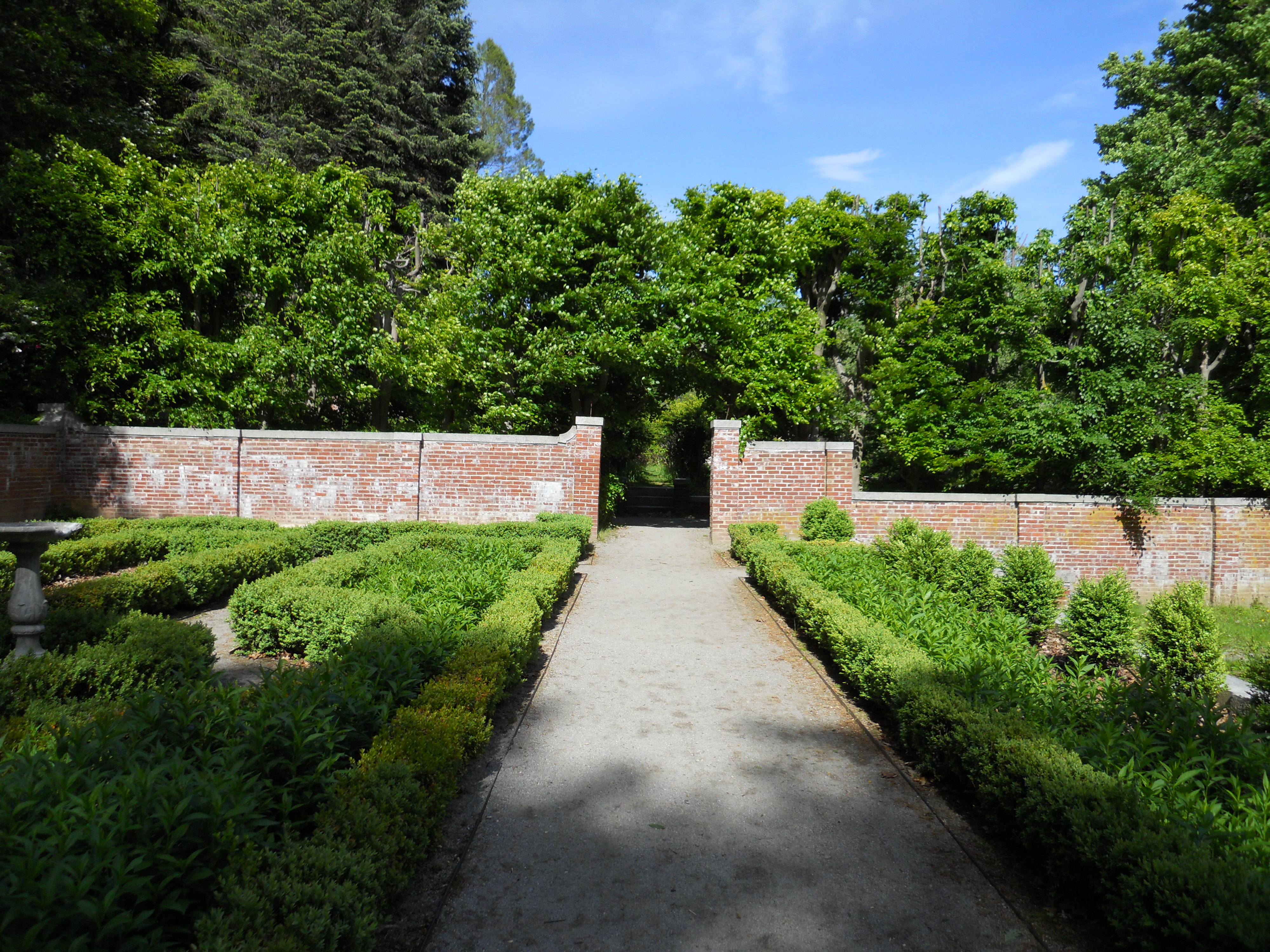
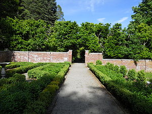 Italian garden, former Moseley Estate. The hedge in the background was intended to screen the greenhouses.
The state park was created from the early 20th century estate of Frederick Strong Moseley, the son of Edward Strong Moseley, 1813–1900, a prominent citizen of Newburyport. Moseley is a variant of Maudesley or Maudesleigh, an English name appearing in the Domesday Book of 1080. The American ancestor, John, entered Massachusetts Bay Colony in 1630, taking up residence in Mattapan, the place depopulated by the death of the Massachusetts tribe of native Americans by smallpox. John's descendants were Protestant ministers, missionaries to the natives, lawyers, patriots and soldiers of the Revolutionary War, abolitionists and soldiers of the Civil War. Up until Edward, the first names were all taken from the Old Testament. Edward's grandfather, Ebenezer, married Martha Strong, adding her name to the customary English triad of names. Martha's brother, Caleb, was a Massachusetts governor and served as one of the first senators from Massachusetts in the new federal government. Ebenezer's father, Samuel, had been a parson in Connecticut.
The Moseleys were generally prolific, bearing several children each family. The descendants are widespread, bearing the same sorts of names and tending to the same sorts of businesses, including a line of financier Frederick Strong Moseleys, although the Newburyport estate is no longer in their ownership. One of the sons of Ebenezer and Martha, also Ebenezer, after graduating from Yale settled in Newburyport in 1805 and had a distinguished career as a lawyer, legislator and officer of the 6th Massachusetts Militia. He helped to found a bank and an insurance company. His son, Edward, went to Yale for a few years, resigned, and became an agent for a Boston merchant in the East India trade, Benjamin Gould, starting as a clerk. He eventually came to own a share in 99 wooden ships built by the Currier shipyard of Newburyport. He was a trustee in a wide variety of organizations, a corporate director of numerous companies, a major philanthropist and especially a successful bank president in Mechanicks National Bank and the Institute for Savings. His special concern was to house and maintain the Newburyport Public Library, founded 1854, in which he was joined by some of his philanthropic friends, such as George Peabody, merchant, slaver and founder of the public libraries in Danvers, Massachusetts and Peabody, Massachusetts, named after him. In 1839 Edward married Charlotte Chapman, a beauty from Newark, New Jersey, who was also an episcopal minister's daughter. They had many children, only five of which survived to adulthood, including Frederick Strong Moseley, born in 1852, who became a broker in Boston and was a director of the Shawmut Bank there. On Edward's death in 1900, the children inherited a not inconsiderable estate. Frederick proceeded to acquire and improve the Newburyport property, consulting and hiring the best landscape architects in Massachusetts of the day.[1]
Originally named Maudesleigh, the estate was created on agricultural fields by landscape architect Martha Brookes Hutcheson, one of the earliest female members of the American Society of Landscape Architects, who designed the grounds around the main house, entry drive, and formal gardens (1904–1906). Lord and Burnham designed various of the greenhouses. At its peak, about 40 staff serviced the estate's three greenhouses, head house, cold frames, espaliered fruit trees, winter plant house, 2-acre (8,100 m2) formal vegetable and cutting garden, 500-foot (150 m) perennial border, Italian garden, rose garden, and rhododendrons, azaleas, and specimen trees, as well as the site's native mountain laurels.
William G. Rantoul, of the Boston firm Jacques and Rantoul, served as the estate's principal architect, creating most of the original architecture in the years 1895-1910. He designed the 72-room main house (demolished 1955) and houses for the coachman, forester, and head gardener. A second large house was built 1939-1941 for Helen Moseley, Frederick's younger daughter. In the early 1950s the privacy and remoteness of the estate were diminished with the construction of Route 95 through the middle of upper woods and the contemporaneous construction of Route 495 at the top of the left bank of the river, both of which became major routes for heavy trucks. Highway noise in the park during business hours is insistent. On the death of the Moseleys the family had the main house torn down. In 1978 Helen's house was destroyed by fire. Today only few of some 30 structures remain.
The state park
In 1985 the property was acquired by the Massachusetts Department of Environmental Management to become Maudslay State Park. The main gate, the drives, the stone bridges and overlooks have survived, as well as stands of lilac, rhododendron and some of the fruit trees. The sites of the grand houses have been leveled. The tops of the foundations are visible in the mowed lawn. The swimming pool of the main house is empty and is choked with thickets. Except for select locations, the gardens and greenhouses have fallen into ruin, the walls scarcely visible on the overgrown hillside. The dairy farm on the property survived and was a working farm in good repair until the early 1980s.
The park service has added a parking lot. A nearby house became the park headquarters. A staff of rangers and grounds employees maintain the meadows and trails and conduct guided tours; however, visitors are welcome to hike the trails, except for areas restricted for ecological purposes. A memorial running course has been delineated. It winds through the meadows and pines. Rest rooms and shower facilities were constructed in the parking lot. Equestrian parties on the larger trails are common. The horses are often brought in privately in trailers, which park in the meadow next to the lot.
Since 1987, Maudslay State Park has been the home of Theater in the Open, which performs three live outdoor shows in the park throughout the year. The theater is also is known for their giant puppet pageant every May called "The Rites of Spring" and their walk in October called "Maudslay is Haunted".
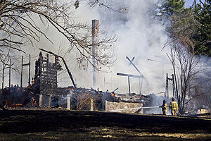 Maudslay State Park barn fire on April 3rd 2010. More photos can be found here
On April 3, 2010 around 1:58 P.M., the Coachman's Barn, which was customarily used for the Theater in the Open, caught fire. The Newburyport, Salisbury and Amesbury Fire Departments got the blaze under control around 3:30 P.M. Only the stone foundation and the chimney survived. The chimney has been taken down for safety reasons. The small house next to the barn was largely untouched.[2][3][4]
Recreational opportunities
- Cross Country Running (Home course of Newburyport High School team)
- Educational/interpretive programs
- Group day use
- Hiking
- Historic site
- Horseback riding trails
- Live theater
- Picnicking
- Restrooms
- Scenic viewing area
- Skiing (cross-country)
- Walking trails
References
- ^ Todd, William C. (1902), "Edward Strong Moseley", Edward Strong Moseley: In Memoriam: 1813-1900, Privately printed, pp. 1–18
- ^ Lovett, Katie Farrell (April 5, 2010). Blaze at Maudslay. newburyportnews.com. http://www.newburyportnews.com/archivesearch/local_story_094212840.html.
- ^ Katzman, Katie Curley (April 6, 2010). Maudslay Park fire called 'suspicious'. newburyportnews.com. http://www.newburyportnews.com/punews/local_story_095232045.html.
- ^ Katzman, Katie Curley (April 13, 2010). Future of Maudslay complex uncertain. newburyportnews.com. http://www.newburyportnews.com/archivesearch/local_story_101212006.html.
- Records of the Moseley Garden Collection
- Currier, John James (1902). History of Newbury, Mass. 1635-1902. Boston: Damrell & Upham. Covers the early history of Newburyport before separation from Newbury. Downloadable from Google Books.
External links
- Maudslay State Park, SeacoastNH.com site.
- Trail Map
- Theater in the Open
- Pictures of Maudslay
- Moulton Castle
Protected Areas of Massachusetts Federal Adams · Boston · Boston African American · Frederick Law Olmsted · John Fitzgerald Kennedy · Longfellow House · Lowell · Minute Man · New Bedford Whaling · Salem Maritime · Saugus Iron Works · Springfield Armory
Appalachian National Scenic Trail · Boston Harbor Islands National Recreation Area · Cape Cod National Seashore · Stellwagen Bank National Marine Sanctuary · Waquoit Bay National Estuarine Research Reserve · West Hill Dam
Assabet River · Great Meadows · Mashpee · Massasoit · Monomoy · Nantucket · Nomans Land · Oxbow · Parker River · Silvio O. Conte · Thacher Island
State Alewife Brook · Ames Nowell · Ashland · Bash Bish Falls · Blackstone River and Canal Heritage · Borderland · Boston Harbor Islands · Bradley Palmer · C. M. Gardner · Callahan · Castle Island State Park · Chicopee Memorial · City Square · Clarksburg · Cochituate · Connecticut River Greenway · Demarest Lloyd · Dighton Rock · Dunn · Ellisville Harbor · Fall River Heritage · Gardner Heritage · Great Brook Farm · Halibut Point · Hampton Ponds · Holyoke Heritage · Hopkinton · Lake Lorraine · Lake Wyola · Lawrence Heritage · Lowell Heritage · Lynn Heritage · Massasoit · Maudslay · Moore · Mount Holyoke Range · Natural Bridge · Nickerson · Pearl Hill · Pilgrim · Quinsigamond · Robinson · Roxbury Heritage · Rutland · Skinner · South Cape Beach · Wahconah Falls · Webb Memorial · Wells · Western Gateway Heritage · Whitehall · Wompatuck
State Parks:
ReservationsBeaver Brook · Belle Isle Marsh · Blue Hills · Breakheart · Charles River · Chestnut Hill · Cutler · Dorchester Shores · Elm Bank · Fort Phoenix · Hammond Pond · Hemlock Gorge · Horseneck Beach · Jug End · Lynn Shore · Middlesex Fells · Mount Everett · Mount Greylock · Mount Sugarloaf · Mount Tom · Myles Standish · Mystic River · Nahant Beach · Nantasket Beach · Nasketucket Bay · Neponset River · Pope John Paul II · Purgatory Chasm · Quincy Quarries · Quincy Shore · Revere Beach · Rumney Marsh · Salisbury Beach · Sandy Point · Scusset Beach · Stony Brook · Upper Charles River · Wachusett Mountain · Walden Pond · Weymouth · Wilson Mountain
State Parks:
OtherAppalachian Trail · Ashuwillticook Rail Trail · Cape Cod Rail Trail · Fort Revere · Lake Dennison Recreation Area · Lower Neponset River Trail · Nashua River Rail Trail · Norwottuck Rail Trail · Quabbin Reservoir · Southwest Corridor Park · Squantum Point Park · Streeter Point Recreation Area · Sudbury Reservoir · Wachusett Reservoir · Ware River Watershed Area
Barnstable · Beartown · Brimfield · Chester-Blandford · DAR · Douglas · Erving · F. Gilbert Hills · Federated Women's Club · Freetown-Fall River · Georgetown Rowley · Granville · Harold Parker · Kenneth Dubuque Memorial · Leominster · Lowell-Dracut-Tyngsboro · Manuel F. Correllus · Mohawk Trail · Monroe · Mount Grace · Mount Washington · Myles Standish · October Mountain · Otter River · Pittsfield · Sandisfield · Savoy Mountain · Shawme-Crowell · Spencer · Tolland · Upton · Wendell · Willard Brook · Willowdale · Windsor
Agawam Lake · Agawam Mill Pond · Ashby · Ashfield Hawley · Attitash · Ayer Game Farm · Baddacook Pond · Bakers Pond · Bay Circuit Trail · Bearse Pond · Becket · Bennett · Birch Hill · Black Brook · Blackstone / West River · Bolton Flats · Boxboro Station · Brayton Point Salt Marsh · Breakneck Brook · Brewer Brook · Bullock Ledge · Burrage Pond · Canoe River · Catamount · Chalet · Chase Garden Creek Salt Marsh · Childs River · Chockalog Swamp · Church Homestead · Clapps Pond · Clinton Bluff · Concord River · Connecticut River · Cook Pond · Copicut · Coy Hill · Crane Pond · Cummington · Cusky Pond · Dartmoor Farm · Darwin Scott Memorial · Day Mountain · Deerfield River · Dogfish Bar Beach Coastal · Dolomite Ledges · Dunstable Brook · E. Kent Swift · Eagle Island · East Mountain · Eastham Salt Marsh · Elbow Meadow · English Salt Marsh · Eugene D. Moran · Facing Rock · Fairfield Brook · Farmington River · Fish Brook · Fisherville Pond · Fisk Forestdale Lot · Fisk Meadows · Five Mile River · Flagg Swamp · Flint Pond · Four Chimneys · Fox Den · Fox Island Salt Marsh · Frances A. Crane · Freetown Swamp · George L. Darey Housatonic Valley · Glen Echo Lake · Gosnold · Grassy Pond (Dennis) · Grassy Pond (Plymouth) · Green River (Franklin County) · Green River (Berkshire County) · Greenfield River · Halfway Pond · Hamilton · Hancock · Harlow / Cooks Pond · Haskell Swamp · Hauk Swamp · Hawksnest State Park · Hawley · Head Of The Plains · Herman Covey · High Ridge · Hinsdale Flats · Hiram H. Fox · Hockomock Swamp · Hog Pond Lot · Honey Pot · Hoosatonic River · Hoosic River · Hop Brook · Housatonic River · Hubbard Brook · Hunting Hills · Hyannis Ponds · Ipswich River · John J. Kelly · Jug End Fen · Jug End · Kampoosa Fen · Katama Plains · Knops Pond · Konkapot River · Lackey Pond · Lake Lorraine · Lake Rohunta · Lake Snipatuit · Lake Warner · Lanesboro · Lawrence Brook · Lawrence Pond Lot · Leadmine · Leyden · Lilly Pond · Little Alum Pond · Long Sought For Pond · Maple Hill · Maple Springs · Martha Deering · Martin H. Burns · Mascuppic Lake · Mashpee Pine Barrens · Mashpee Pond Lot · Mashpee River · Massachusetts Military Reservation · Mckinstry Brook · Meetinghouse Swamp · Merrill Pond · Miacomet Heath · Mill River · Millers River · Mine Brook · Montague Plains · Montague · Moose Brook · Moose Brook · Moose Hill · Mossy Pond · Mount Watatic Reservation · Mt. Esther · Mt. Toby Highlands · Mt. Toby · Mt. Tom · Muddy Brook · Muddy Pond · Mulpus Brook · Nashua River · Natty Brook · Nemasket River · Nissitissit River · Noquochoke · Nordeen Marsh · North Brookfield · North Shore Salt Marsh · Northboro · Oakham · Olivers Pond · Orange · Otis · Packard Pond · Palmer · Pantry Brook · Pauchaug Brook · Peru · Peterson Swamp · Phillipston · Podunk Marsh · Poland Brook · Popple Camp · Popponesset Beach · Poutwater Pond · Powell Brook · Prince River · Provincetown Route 6 Corridor · Purchade Brook · Quaboag · Quacumquasit · Quag Pond Bog · Quashnet River · Quashnet Woods State Reservation · Quinapoxet River · Quinsigamond Marsh · Quisset · Raccoon Hill · Rainbow Beach · Red Brook · Richardson · Robbins Pond · Rochester · Rocky Gutter · Rowe · Salisbury Salt Marsh · Salisbury Salt Marsh · Sandwich Game Farm · Sandy Pond · Satan's Kingdom · Savage Hill · Savoy · Sawmill River · Scorton Creek Coastal · SE Mass Bioreserve · Sevenmile River · Shattuck Brook · Sheperds Island · Shubael Pond · Sibley Brook · Sly Pond · South Barrier Beach · South Meadow Pond · South Shore Salt Marsh · South Triangle Pond · Southampton · Southwick · Spectacle Pond · Springhill Lot · Sputtermill Pond · Squannacook River · Stafford Hill · Sudbury River · Sunderland Islands · Taconic Mountain · Taunton River · Taunton River · Tekoa Mountain · Thad Ellis · Thayer Pond · Three Mile Pond · Townsend · Townsend Hill · Trapfall Brook · Triangle Pond · Tully Brook · Tully Mountain · Tully River · Wakeby Pond · Wales · Walnut Hill · Ware River · Warwick · Wendell · West Meadows · Westboro · Westfield River · Westfield · Weymouth Back River · Whately Great Swamp · Whately Ponds · Whately · Wilbraham Game Farm · William Forward · Williams River · Williamsburg · Winimusset · Wolf Swamp ·Billingsgate Island · Carr Island · E. Howe Forbush · Egg Rock · Grace A. Robson · J.C. Phillips · Knight · Penikese Island · Ram Island (Salisbury) · Ram Island (Mattapoisett) · Susan B. Minns · Tarpaulin Cove · Watatic Mountain ·Private Roger and Virginia Drury Preserve · Tatkon Preserve · McElwain-Olsen Preserve · Reed Brook Preserve · Hawley Bog Preserve · Stacy Mountain Preserve · Greene Swamp Preserve · Black Pond Bog Nature Preserve · Halfway Pond Island Preserve · Grassy Pond Preserve · Boat Meadow Preserve · Sandy Neck Preserve · Hockomock Swamp · David H. Smith Preserve and Fire Trail · Hoft Farm Preserve · Katama Plains Preserve · Francis Newhall Woods Nature and Wildlife Preserve · Miacomet Moors Preserve · Homer-Watcha Preserve ·
Agassiz Rock · Appleton Farms · Appleton Farms Grass Rides · Ashintully Gardens · Bartholomew's Cobble · Bear's Den · Bear Swamp · Colonel John Ashley House · Francis William Bird Park · Eleanor Cabot Bradley Estate · Bridge Island Meadows · Brooks Woodland Preserve · William Cullen Bryant Homestead · Cape Poge Wildlife Refuge · Cedariver · Castle Hill · Chapel Brook · Charles River Peninsula · Chase Woodlands · Chesterfield Gorge · Coolidge Reservation · Copicut Woods · Cormier Woods · Coskata-Coatue Wildlife Refuge · Crane Beach · Crane Wildlife Refuge · Crowninshield Island · Dexter Drumlin · Dinosaur Footprints · Doane's Falls · Doyle Reservation · Dry Hill · East Over Reservation · Elliott Laurel · Field Farm · Fork Factory Brook · Glendale Falls · Goose Pond Reservation · Greenwood Farm · Halibut Point Reservation · Hamlin Reservation · Holmes Reservation · Governor Hutchinson's Field · Jacobs Hill · Little Tom Mountain · Long Hill · Long Point Wildlife Refuge · Lowell Holly Reservation · Lyman Reserve · Malcolm Preserve · Mashpee River Reservation · McLennan Reservation · Medfield Meadow Lots · Medfield Rhododendrons · Menemsha Hills · Misery Islands · Mission House · Monument Mountain · Moose Hill Farm · Mount Ann Park · Mountain Meadow Preserve · Mytoi · Naumkeag · Noanet Woodlands · Noon Hill · Norris Reservation · North Common Meadow · Norton Point Beach · Notchview · Old Manse · Old Town Hill · Peaked Mountain · Pegan Hill · Peters Reservation · Petticoat Hill · Pierce Reservation · Pine and Hemlock Knoll · Powisset Farm · Questing · Quinebaug Woods · Ravenswood Park · Redemption Rock · Rock House Reservation · Rocky Narrows · Rocky Woods · Royalston Falls · Shattuck Reservation · Signal Hill · Slocum's River Reserve · Stavros Reservation · The Stevens-Coolidge Place · Swift River Reservation · Tantiusques · Tully Lake Campground · Two Mile Farm · Tyringham Cobble · Ward Reservation · Wasque · Weir Hill · Weir River Farm · Westport Town Farm · Whitney and Thayer Woods · World's End ·
Arcadia · Broad Meadow Brook · Broadmoor · Drumlin Farm · High Ledges · Ipswich River · North River · Pleasant Valley · Stony Brook · Wachussett Meadow · Wellfleet Bay
OtherConcord Land Conservation Trust · Harvard Forest · Lincoln Land Conservation Trust ·
Executive Office of Energy and Environmental Affairs (Massachusetts) Categories:- Massachusetts state parks
- Parks in Essex County, Massachusetts
- Newburyport, Massachusetts

Wikimedia Foundation. 2010.