- Massachusetts Route 9
-
"Ted Williams Highway" redirects here. For the tunnel in Boston, see Ted Williams Tunnel.
Route 9
Worcester-Boston Turnpike
Ted Williams Highway
United Spanish War Veterans Highway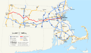
Route information Length: 135.5516 mi[1] (218.1492 km) Existed: by 1933 – present Major junctions West end:  US-20 in Pittsfield
 I-91 in Northampton
 US-202 in Belchertown
 I-290 in Worcester
US-20 in Shrewsbury
 I-495 in Westborough
 I-90 in Framingham

 I-95/Route 128 in Wellesley
East end:  Route 28 in Boston
Highway system Massachusetts State Highway Routes
←  Route 8A
Route C9  →
→Route 9 is a major east–west state highway in Massachusetts. Along with U.S. Route 20, Route 2 and the Massachusetts Turnpike, Route 9 is one of the major east-west routes of Massachusetts, and like the others its eastern terminus is in Boston. Starting at Copley Square and passing along Huntington Avenue, Route 9 is a limited access route through the MetroWest suburbs to Worcester, and is also a major alternative to the Pike's toll road west of the city. After passing along major city streets in that city, the road becomes a country route, passing through the central Worcester Hills, the Pioneer Valley and the city of Northampton, and into the Berkshire Hills. The road ends near the center of the city of Pittsfield.
Contents
History
From Dalton to Goshen in the Berkshires, the road follows the old Berkshire Trail. The massive expansion of the University of Massachusetts Amherst transformed that part of Route 9 in the late 20th century; this otherwise rural part of the route now has several shops, restaurants, and the mid-sized Hampshire Mall. Between Worcester and Boston, Route 9 follows the path of the 19th Century Worcester Turnpike, opened in 1810. This route originally included a floating bridge over Lake Quinsigamond in Shrewsbury. In the 20th century, Route 9 became the focus for urban sprawl in towns like Newton and Wellesley. Further west, in Framingham, Route 9 was home to one of the first modern shopping malls, the aptly named Shoppers World.
In Framingham, Route 9 is officially the "Ted Williams Highway", named after the Red Sox sports legend Ted Williams, who sported that number. In Newton, it is officially the "United Spanish War Veterans Highway".
From 1903 to 1932, the Boston and Worcester Street Railway ran mostly via Route 9. Today the E branch of the MBTA's Green Line follows Route 9 along Huntington Avenue.
An a cappella group called Route 9, named after the highway, exists at Amherst College.
Route description
Route 9 passes through six counties and twenty-eight cities and towns. It begins in the western Massachusetts city of Pittsfield, at the junction of U.S. Routes 7 and 20, where the latter leaves its concurrency with the former. Concurrent with Route 7 for its first mile through the center of the city, it then turns east, passing through the towns of Dalton and Windsor in Berkshire County. It continues its winding pass through the small towns of The Berkshires in Berkshire and western Hampshire Counties before passing through the center of Northampton, passing Smith College before its first interstate junction, at Interstate 91. It then crosses the Connecticut River at the Calvin Coolidge Bridge, just downstream from Elwell Island. It goes past the retail area of Hadley before passing the University of Massachusetts Amherst and Amherst College. From Amherst, it winds its way into western Worcester County, south of the Quabbin Reservoir, through small towns until it makes its way into the city of Worcester.
Once in Worcester, Route 9 becomes a major thoroughfare through the city, as Park Street, Highland Avenue (which passes Worcester Center Boulevard), before passing under Interstate 290) and Belmont Street, where University of Massachusetts Medical School and the former Worcester State Hospital are located. From Worcester, it crosses Lake Quinsigamond into Shrewsbury. At this point, Route 9 becomes the main retail artery of the MetroWest region. Several plazas and chain stores are located along the route as it makes its way towards Northborough, where it crosses U.S. Route 20; Westborough, where it crosses Interstate 495; and eventually in the Golden Triangle retail area of Framingham and Natick, after crossing the Massachusetts Turnpike. It passes Shopper's World and the Natick Collection, New England's largest mall.
Beginning in the Golden Triangle, Route 9 becomes one of the major routes into Boston, serving as a valuable bypass to the Mass Pike and its tolls. It crosses Interstate 95 (also known as Massachusetts Route 128) in Wellesley before crossing the Charles River into Newton and Brookline. It enters the city of Boston by crossing over Brookline's former namesake, the Muddy River, part of the Emerald Necklace. at this point it becomes Huntington Avenue, also known as "Avenue of the Arts." It passes the Longwood Medical and Academic Area, which includes Brigham and Women's Hospital, Harvard Medical School and other hospitals; the Museum of Fine Arts; and several colleges and universities, including Northeastern University. This stretch is also a major site of baseball history; the first game of the 1903 World Series, baseball's first true World Series, was played at the Huntington Avenue Grounds, the original home of the Boston Red Sox. (The site is now part of Northeastern's campus.) Route 9 continues past Symphony Hall and The First Church of Christ, Scientist, which is the mother church of Christian Science. It then passes Copley Place and the Prudential Center complex, before splitting, the westbound half onto Stuart Street, the eastbound onto Saint James Street, past Copley Square; both the eastbound and westbound segments of Route 9 end at Route 28 on Clarendon Street, which are on either side of the John Hancock Tower.
Junction list
County Location Mile Exit Destinations Notes Berkshire Pittsfield 0.00  US 7 south
Western terminus of Route 9; western end of concurrency with US Route 7 1.1 US 7 northEastern end of concurrency with US Route 7 3.6  Route 8 north
Western end of concurrency with Route 8 Dalton 5.9 Route 8 south / Route 8A westEastern end of Route 8 concurrency; western end of Route 8A concurrency Windsor 12.2 Route 8A eastEastern end of Route 8A concurrency Hampshire Cummington 21.8  Route 112 south
Western end of Route 112 concurrency Goshen 28.8 Route 112 northEastern end of Route 112 concurrency Williamsburg 34.1  Route 143 west
Eastern terminus of Route 143 Northampton 42.3  Route 66 west
Eastern terminus of Route 66 42.3  Route 10 south
Western end of Route 10 concurrency 42.6  Route 10 north / US 5
Eastern end of Route 10 concurrency; junction of U.S. Route 5 43.6 I-91Junction of Interstate 91 (Exit 16) 43.8 Connecticut River crossing at Calvin Coolidge Bridge Hadley 45.5  Route 47
48.2  Route 116 north
Western end of Route 116 concurrency Amherst 49.7 Route 116 southEastern end of Route 116 concurrency Belchertown 58.6 US 20259.5  Route 21
Northern terminus of Route 21; road formerly went north before building of the Quabbin Reservoir Ware 68.9  Route 32 south
Eastern end of Route 32 concurrency Worcester West Brookfield 70.5 Route 32 northEastern end of Route 32 concurrency at county line 74.7 
 Route 19 south / Route 67 south
Northern terminus of Route 19; western end of Route 67 concurrency 75.7 Route 67 northEastern end of Route 67 concurrency Brookfield 78.5  Route 148
Short (30 yd) overlap on Route 9 Spencer 83.4  Route 49 south
84.9  Route 31 south
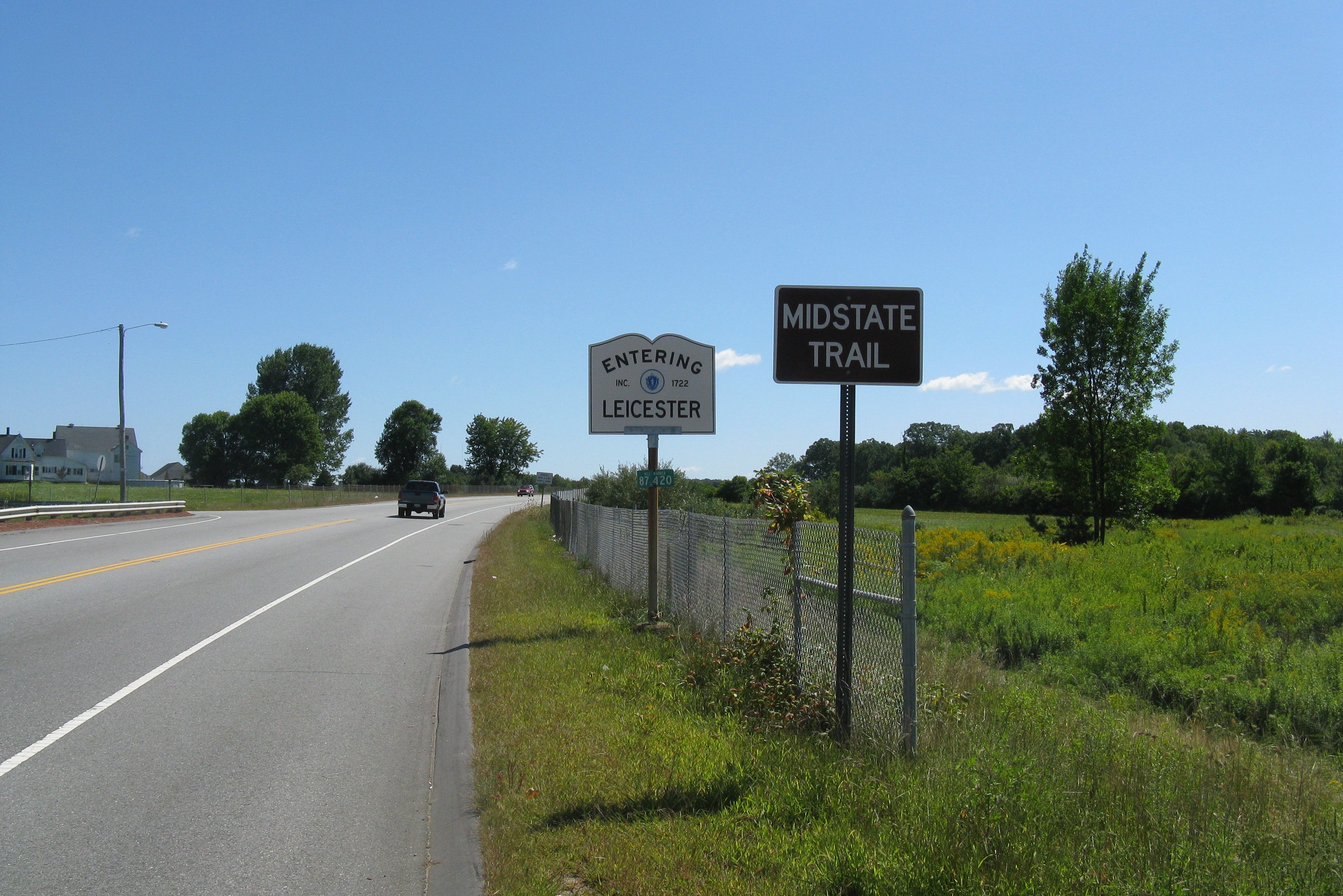
Western end of Route 31 concurrency 85.1 Route 31 northEastern end of Route 31 concurrency Leicester 89.9  Route 56
Worcester 93.8  Route 12 south
Western end of Route 12 concurrency 95.5  Route 122
96.1 Route 12 northEastern end of Route 12 concurrency 97.0  Route 70 north
Southern terminus of Route 70 at Worcester Center Blvd. 97.3 I-290Southbound entrance and northbound exit (17) only from I-290 99.1 Lake Quinsigamond crossing over Kenneth F. Burns Memorial Bridge Shrewsbury 101.6  Route 140
Northborough 103.7 US 20Cloverleaf interchange over U.S. Route 20 Westborough 105.6  Route 135
exit ramps to southbound lane only; northbound lane at-grade 107.5  Route 30
Single exit ramp interchange over Route 30 108.7 I-495Cloverleaf interchange under I-495 (Exits 23 A-B) Southborough 111.1  Route 85
Cloverleaf interchange under Route 85 Middlesex Framingham 113.6 I-90Entrance to Massachusetts Turnpike at Exit 12 116.2 Route 30 westWestern end of Route 30 concurrency 117.1 Route 30 eastEastern end of Route 30 concurrency (westbound only) 117.4  Route 30 east / Route 126
Eastern end of Route 30 concurrency (Eastbound); junction of Route 126 118.3 Ring Road Shoppers World entrance Natick 118.6 Speen Street Access to Natick Collection and the Massachusetts Turnpike 119.9  Route 27
Cloverleaf interchange under Route 27 Norfolk Wellesley 124.4  Route 16
At-grade access to Route 16 on eastbound side only 124.7 Route 16Exit ramp from Route 9 to Route 16 on westbound side only 126.4 I-95 / Route 128Cloverleaf interchange under Interstate 95/Route 128 Exits 20 A-B Middlesex Newton 126.9 Charles River crossing at town line Norfolk Brookline 129.9 Town line - The Mall at Chestnut Hill Suffolk Boston 132.9 Muddy River - Emerald Necklace 134.6 Massachusetts Avenue Location of Boston Symphony Hall and First Church of Christ, Scientist 135.2 Exeter Street Split of eastbound and westbound lanes into Stuart Avenue and Avenue of the Arts 135.5 Route 28Eastern terminus of Route 9 at Clarendon Street, both lanes 1.000 mi = 1.609 km; 1.000 km = 0.621 mi
Concurrency terminus • Closed/Former • Incomplete access • UnopenedGallery
References
- ^ Executive Office of Transportation, Office of Transportation Planning - 2005 Road Inventory
External links
Categories:- Numbered routes in Massachusetts
- Pre-freeway turnpikes in the United States


Wikimedia Foundation. 2010.