- Massachusetts Route 85
-
Route 85

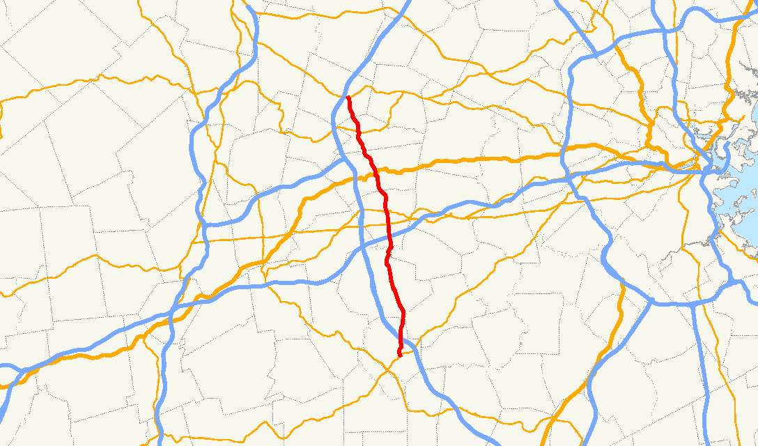
Route information Length: 21.0097 mi[1] (33.8118 km) Major junctions South end:  Route 16 in Milford
 I-495 in Milford
 Route 9 in Southborough
 Route 30 in Southborough
 US-20 in Marlborough
 I-290/I-495 (via Super 2 connector through Marlborough) in Hudson
 Route 62 in Hudson (rotary)
North end:  Route 117 in Bolton
Highway system Massachusetts State Highway Routes
←  I-84
I-84Route 88  →
→Route 85, is a north–south state highway in Massachusetts, United States. It passes through the heart of Boston's MetroWest region, through towns on the eastern edge of Worcester County and western edge of Middlesex County, crossing the border between the two counties four times. Throughout its entire distance, Route 85 runs parallel to I-495, never passing more than two miles east of it.
Contents
Route description
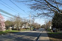
Route 85 begins in the town of Milford at Route 16, just east of the downtown area. It passes east of Milford Pond before meeting I-495 at Exit 20. From there, Route 85 heads northward into Hopkinton, passing the eastern side of Echo Lake. It intersects Route 135 at the center of town, less than a quarter mile west of the start line of the Boston Marathon. It then passes through Hopkinton State Forest and past the Hopkinton Reservoir before entering the town of Southborough.
In Southborough, Route 85 crosses under I-90 (the Mass Pike) without junction; the nearest exit is in neighboring Framingham. It then meets Route 9, the second of the four major east-west routes out of Boston, in an elevated four-way cloverleaf intersection. It then crosses the Sudbury Reservoir before meeting Route 30 at the center of town. From there, Route 85 continues northward into Marlborough, meeting U.S. Route 20 in the downtown area. It then crosses the far western edge of the Fort Meadow Reservoir before crossing into Hudson.
Shortly after entering Hudson, Route 85 meets Hudson Street, the super two connector road between Route 85 and the junction of I-290 and I-495 at I-495's Exit 25 and I-290's terminus, Exit 26. From there Route 85 heads north, crossing the Assabet River before meeting Route 62, passing concurrently with that route through Wood Square before Route 85 continues northward. After passing into Bolton, the route passes between Little Pond and West Pond before ending at Route 117, less than a half mile east of I-495's exit 27.
Future
Improvements to Route 85 in Hudson
In 2011 a $10.8 million project to reconstruct 7,700 feet (1.5 miles) from School Street/Park Street to Marlborough C.L will begin. The project will consist of 11-foot (3.4 m) travel lanes and 4-foot (1.2 m) bike shoulders with 5.5-foot (1.7 m) concrete sidewalks throughout the project corridor. The Walmart Driveway will be reconstructed with bicycle accommodation, ADA compliance and a new traffic signal. At the Intersection of the Route 85 Connector and Technology Drive the Intersection will be Reconstructed. A new northbound left turn lane will be constructed, new through lane constructed on Technology Drive, new through lane on Route 85 Connector and a new wire traffic signal. The section between Route 85 Connector and Broad Street will consist of four lanes (two in each dirrection) with a 4-foot (1.2 m) raised concrete median. At the intersection of Broad Street the existing signal will be replaced with a two-lane roundabout. The roadway will be widened to four lanes (two in each direction)from Houghton Street to Broad Street. A new traffic signal will be installed at R.K Town Centre Drive with new turn lane. A new traffic signal will be installed at Giason Street. A new northbound left turn lane with a new traffic signal will be installed at Brighman Street. From Brighman Street to Park Street the roadway will be cold-planed and resurfaced with drainage, curbing, sidewalks and driveways included. At Park Street/ School Street a new traffic signal will be installed and a new southbound right turn lane will be constructed.
Hudson Route 85 Bridge
Beginning in 2013, the MassDOT will replace the existing structurally deficient arch bridge with a new bridge. The estimated cost is $7 million. The project is funded as part of the Accelerated Bridge Program and will use an innovative construction. The new bridge will consist of new concrete reinforced abutments and a new concrete NEXT beam superstructure.
Junction list

Southbound in Hopkinton County Location Mile Roads intersected Notes Worcester Milford 0.00 Route 16Southern terminus of Route 85.
To Route 109, via Route 16 East.
1.3 Interstate 495I-495 Exit 20. Middlesex Hopkinton 5.9  Route 135
Worcester Southborough 9.4  I-90/Mass Pike
Crossing of Route 85 and I-90 without junction. 10.4 Route 9Cloverleaf interchange. 11.4 Route 30Middlesex Marlborough 14.5 U.S. Route 20Hudson 16.9 Hudson Street
(Route 85 Connector)Super-2 connector to I-290/I-495.18.1 Route 62Rotary; brief, 130 yards (120 m) concurrency between Routes 62/85. Worcester Bolton 21.01 Route 117Northern terminus of Route 85.
To I-495, via Route 117 West.Street names
Route 85 is known by the following street names:
Milford- Cedar Street
Hopkinton
- Hayden Rowe Street
- Grove Street
- Cedar Street
Southborough
- River Street
- Cordaville Road
- Marlboro Road
Marlborough
- Maple Street
- South Bolton Street
- Bolton Street
Hudson
- Washington Street
- Lincoln Street
Bolton
- Hudson Road
References
http://www.env.state.ma.us/mepa/mepacerts/2010/sc/enf/14638enf.pdf
Categories:- Numbered routes in Massachusetts
- Transportation in Worcester County, Massachusetts
- Transportation in Middlesex County, Massachusetts


Wikimedia Foundation. 2010.