- Southborough, Massachusetts
-
Southborough, Massachusetts — Town — Center of Southborough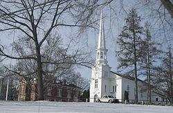
SealLocation in Worcester County in Massachusetts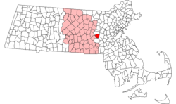
Coordinates: 42°18′20″N 71°31′30″W / 42.30556°N 71.525°WCoordinates: 42°18′20″N 71°31′30″W / 42.30556°N 71.525°W Country United States State Massachusetts County Worcester Settled 1660 Incorporated 1727 Government – Type Open town meeting – Moderator David A. Coombs – Town
AdministratorJean E. Kitchen – Board of
SelectmenBonnie J. Phaneuf
William J. Boland
John RooneyArea – Total 15.7 sq mi (40.6 km2) – Land 14.2 sq mi (36.6 km2) – Water 1.5 sq mi (3.9 km2) Elevation 306 ft (93 m) Population (2010) – Total 9,767 – Density 623.1/sq mi (240.6/km2) Time zone Eastern (UTC-5) – Summer (DST) Eastern (UTC-4) ZIP code 01772, 01745 Area code(s) 508 / 774 FIPS code 25-63165 GNIS feature ID 0618382 Website http://www.southboroughtown.com/ Southborough is an affluent town in Worcester County, Massachusetts, United States. It incorporates the smaller villages of Cordaville, Fayville, and Southville. Its name is often informally shortened to Southboro, a usage seen on many area signs and maps. Its population was 9,767 at the 2010 census.
Land use is primarily residential, with substantial open space. A quarter of the town's area is flooded by the Sudbury Reservoir. Light industrial land use is concentrated along main roads, primarily Massachusetts Route 9, and there are several small business districts in the villages and along Route 9. Southborough was named Number 31 in the nation on CNN Money's "100 Best Places to Live" in 2009.[1]
Contents
History
Southborough was first settled in 1660 and was officially incorporated in 1727. Southborough was primarily a farming community until mills began to tap the small rivers that ran through the town. By the end of the 19th century, the town was home to the manufacture of plaster, boots and shoes, among other things.
In 1898 the Fayville Dam was constructed to produce several reservoirs to supply a growing Boston with water. As a result, manufacturing vanished and Southborough did not see substantial growth until the high-tech boom of the 1970s.
Geography
According to the United States Census Bureau, the town has a total area of 15.7 square miles (41 km2), of which 14.1 square miles (37 km2) is land and 1.5 square miles (3.9 km2), or 9.64%, is water.
Adjacent towns
Southborough is located in eastern Massachusetts, bordered by Hopkinton on the south, Framingham and Ashland on the east, Westborough and Northborough on the west, and Marlborough on the north.
Demographics
Historical populations Year Pop. ±% 1850 1,347 — 1860 1,854 +37.6% 1870 2,135 +15.2% 1880 2,142 +0.3% 1890 2,114 −1.3% 1900 1,921 −9.1% 1910 1,745 −9.2% 1920 1,838 +5.3% 1930 2,166 +17.8% 1940 2,231 +3.0% 1950 2,760 +23.7% 1960 3,996 +44.8% 1970 5,798 +45.1% 1980 6,193 +6.8% 1990 6,628 +7.0% 2000 8,781 +32.5% 2001* 9,247 +5.3% 2002* 9,437 +2.1% 2003* 9,535 +1.0% 2004* 9,652 +1.2% 2005* 9,651 −0.0% 2006* 9,680 +0.3% 2007* 9,723 +0.4% 2008* 9,660 −0.6% 2009* 9,714 +0.6% 2010 9,767 +0.5% * = population estimate.
Source: United States Census records and Population Estimates Program data.[2][3][4][5][6][7][8][9][10][11]As of the census[12] of 2000, there were 8,781 people, 2,952 households, and 2,426 families residing in the town. The population density was 620.7 inhabitants per square mile (239.7 /km2). There were 2,997 housing units at an average density of 211.8 per square mile (81.8 /km2). The racial makeup of the town was 94.47% White, 0.54% African American, 0.07% Native American, 3.52% Asian, 0.05% Pacific Islander, 0.50% from other races, and 0.87% from two or more races. Hispanic or Latino of any race were 1.50% of the population.
There were 2,952 households out of which 47.5% had children under the age of 18 living with them, 73.9% were married couples living together, 6.0% had a female householder with no husband present, and 17.8% were non-families. 14.0% of all households were made up of individuals and 5.5% had someone living alone who was 65 years of age or older. The average household size was 2.97 and the average family size was 3.30.
In the town the population was spread out with 32.1% under the age of 18, 3.7% from 18 to 24, 32.2% from 25 to 44, 23.9% from 45 to 64, and 8.1% who were 65 years of age or older. The median age was 37 years. For every 100 females there were 99.9 males. For every 100 females age 18 and over, there were 95.2 males.
The median income for a household in the town was $132,986, and the median income for a family was $129,454, although according to CNN, median family income had risen to $148,297 by 2009.[13] Males had a median income of $80,961 versus $50,537 for females. The per capita income for the town was $44,310. About 0.4% of families and .6% of the population were below the poverty line, including 0.7% of those under age 18 and 4.5% of those age 65 or over.
Government
The form of town government is open town meeting, in which the voters of the town act as the legislature. Town Meeting is managed by the Moderator, who also appoints most of the membership of the unelected boards.
The three members of the Board of Selectmen, however, are elected to act as the executive body of the government. The Selectmen delegate day-to-day operations to the Town Manager.
Southborough has three school committees:
- Southborough K-8 School Committee
- Northborough-Southborough Regional School Committee
- Assabet Valley Regional Vocational-Technical School Committee
Southborough's town elections are non-partisan.
Almost sixty percent of current voters registered without enrolling in any political party. Democrats slightly outnumber Republicans in the remaining forty percent. Minor party enrollments are negligible.
County government: Worcester County Clerk of Courts: Dennis P. McManus (D) District Attorney: Joseph D. Early, Jr. (D) Register of Deeds: Anthony J. Vigliotti (D) Register of Probate: Stephen Abraham (D) County Sheriff: Lew Evangelidis (R) State government State Representative(s): Carolyn Dykema (D), pcts. 2 and 3
Steven Levy (R), pct. 1State Senator(s): Jamie Eldridge (D) Governor's Councilor(s): Marilyn M. Petitto Devaney (D) Federal government U.S. Representative(s): James P. McGovern (D-3rd District) U.S. Senators: John Kerry (D), Scott Brown (R) Library
The public library in Southborough was established in 1852.[14][15] In fiscal year 2008, the town of Southborough spent 0.95% ($370,390) of its budget on its public library—some $38 per person.[16]
Education
Public and private educational campuses frame Southborough's small New England downtown.
Public schools
Southborough has six public schools. The four elementary and middle schools are inside town limits; the two high schools are regional schools in adjoining towns.
- Mary E. Finn School - preschool, kindergarten, and 1st grade
- Albert S. Woodward School - 2nd and 3rd grade
- Margaret A. Neary School - 4th and 5th grade
- P. Brent Trottier Middle School - 6th, 7th, and 8th grade
- Algonquin Regional High School in Northborough, Massachusetts - 9th to 12th
- Assabet Valley Regional Vocational Technical High School in Marlborough, Massachusetts - 9th to 12th
Private schools
Southborough is home to a private secondary school, St. Mark's, which was founded in 1865 by Joseph Burnett. One of the oldest junior boarding schools in the nation, the Fay School, was founded a year later in 1866 by Joseph Burnett's first cousin Harriet Burnett Fay.
Transportation
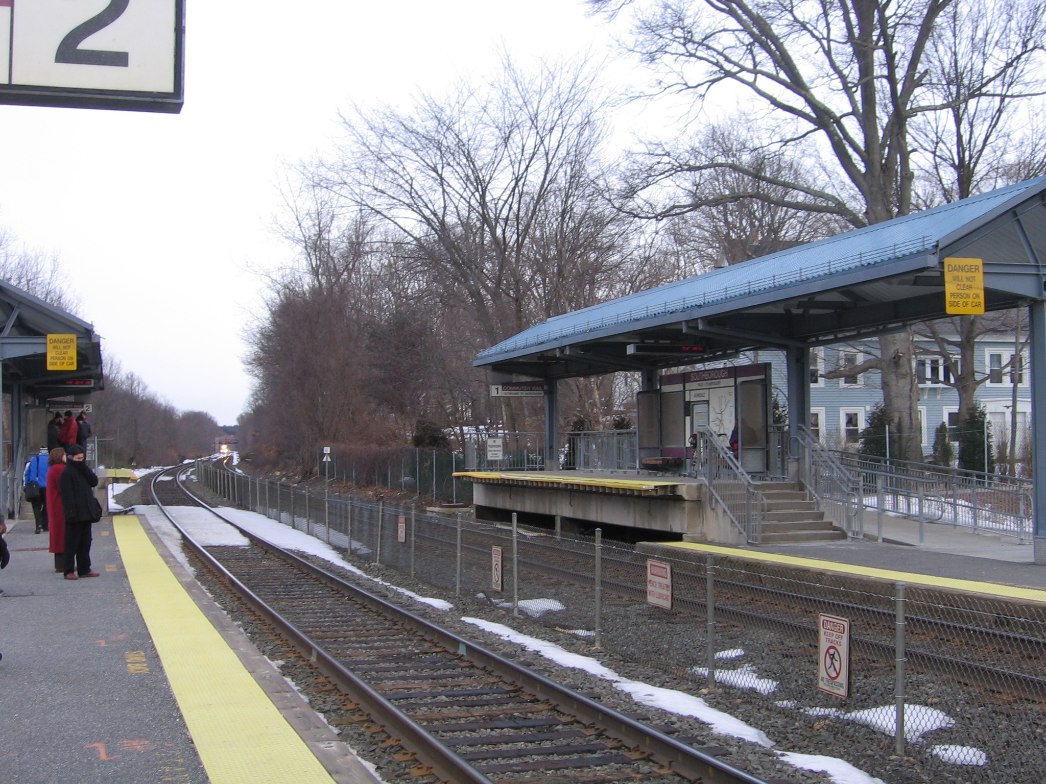
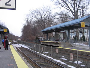 The 7:33 AM Express MBTA Commuter Rail Train about to arrive at Southborough Station on March 7, 2007
The MBTA Commuter Rail's Framingham/Worcester Line train stops at Southborough Station, which opened to commuters on June 22, 2002. The station is located in the Cordaville neighborhood, on Route 85 near the border with Hopkinton. As of October 2007, ten daily round-trip trains provide service to Boston via the Back Bay and South Station terminals.
Interstate 495 and the Massachusetts Turnpike (Interstate 90) both pass through Southborough, although neither have interchanges within town limits. Routes 9 and 30 are east-west routes passing through Southborough, while Route 85 serves the town as a north-south route.
Points of interest
Some interesting places in Southborough are:
- 9/11 Field
- Arts Center
- Village House
- Rural Cemetery
- Breakneck Hill conservation land
- Sudbury Reservoir Trail
- St. Mark's School
Annual events
Southborough celebrates Heritage Day on Columbus Day. The day starts with a brief, noisy parade down Main St., anchored by youth organizations, the Algonquin High School marching band, and police and fire vehicles. The parade ends adjacent to the St. Mark's green, where vendors and local organizations set up booths offering crafts, food, knick-knacks, and information.
There are also events on the prior Sunday, including a five-mile run, a three-mile walk, and a pumpkin-carving contest that is judged at dusk.
Notable residents
- Marty Barrett, former Red Sox second baseman, who now resides in Las Vegas
- Storm Large, musician and actress[17]
- Warner Oland (1879–1938), actor and star of sixteen 'Charlie Chan' movies from 1931–1937
- Rico Petrocelli, former Red Sox third baseman
- Mike Port, former Red Sox General Manager and executive
- E. C. Spykman (1896–1965), children's novelist and journalist
- Robert H. Thayer (1901–1984), lawyer, naval officer and diplomat
- Luis Tiant,[18] former Red Sox pitcher
- Ramiro Torres, radio personality
- Michael Weishan, former PBS host
- Jeffrey S.S. Johnson, actor, star of 'Letters To God', http://www.imdb.com/name/nm1378502/
- Winfield Scott Hammond(1863-1915), Congressman, Governor of Minnesota from January 5, to December 30, 1915.
Media
References
- ^ CNN Money. Retrieved July 13, 2009.
- ^ "TOTAL POPULATION (P1), 2010 Census Summary File 1, All County Subdivisions within Massachusetts". United States Census Bureau. http://factfinder2.census.gov/bkmk/table/1.0/en/DEC/10_SF1/P1/0400000US25.06000. Retrieved September 13, 2011.
- ^ "Massachusetts by Place and County Subdivision - GCT-T1. Population Estimates". United States Census Bureau. http://factfinder.census.gov/servlet/GCTTable?_bm=y&-geo_id=04000US25&-_box_head_nbr=GCT-T1&-ds_name=PEP_2009_EST&-_lang=en&-format=ST-9&-_sse=on. Retrieved July 12, 2011.
- ^ "1990 Census of Population, General Population Characteristics: Massachusetts". US Census Bureau. December 1990. Table 76: General Characteristics of Persons, Households, and Families: 1990. 1990 CP-1-23. http://www.census.gov/prod/cen1990/cp1/cp-1-23.pdf. Retrieved July 12, 2011.
- ^ "1980 Census of the Population, Number of Inhabitants: Massachusetts". US Census Bureau. December 1981. Table 4. Populations of County Subdivisions: 1960 to 1980. PC80-1-A23. http://www2.census.gov/prod2/decennial/documents/1980a_maABC-01.pdf. Retrieved July 12, 2011.
- ^ "1950 Census of Population". Bureau of the Census. 1952. Section 6, Pages 21-10 and 21-11, Massachusetts Table 6. Population of Counties by Minor Civil Divisions: 1930 to 1950. http://www2.census.gov/prod2/decennial/documents/23761117v1ch06.pdf. Retrieved July 12, 2011.
- ^ "1920 Census of Population". Bureau of the Census. Number of Inhabitants, by Counties and Minor Civil Divisions. Pages 21-5 through 21-7. Massachusetts Table 2. Population of Counties by Minor Civil Divisions: 1920, 1910, and 1920. http://www2.census.gov/prod2/decennial/documents/41084506no553ch2.pdf. Retrieved July 12, 2011.
- ^ "1890 Census of the Population". Department of the Interior, Census Office. Pages 179 through 182. Massachusetts Table 5. Population of States and Territories by Minor Civil Divisions: 1880 and 1890. http://www2.census.gov/prod2/decennial/documents/41084506no553ch2.pdf. Retrieved July 12, 2011.
- ^ "1870 Census of the Population". Department of the Interior, Census Office. 1872. Pages 217 through 220. Table IX. Population of Minor Civil Divisions, &c. Massachusetts. http://www2.census.gov/prod2/decennial/documents/1870e-05.pdf. Retrieved July 12, 2011.
- ^ "1860 Census". Department of the Interior, Census Office. 1864. Pages 220 through 226. State of Massachusetts Table No. 3. Populations of Cities, Towns, &c.. http://www2.census.gov/prod2/decennial/documents/1860a-08.pdf. Retrieved July 12, 2011.
- ^ "1850 Census". Department of the Interior, Census Office. 1854. Pages 338 through 393. Populations of Cities, Towns, &c.. http://www2.census.gov/prod2/decennial/documents/1850c-11.pdf. Retrieved July 12, 2011.
- ^ "American FactFinder". United States Census Bureau. http://factfinder.census.gov. Retrieved 2008-01-31.
- ^ "6-Figure Towns". CNN. July 21, 2009. http://money.cnn.com/galleries/2009/moneymag/0907/gallery.bplive_6_figure_towns.moneymag/2.html. Retrieved May 23, 2010.
- ^ C.B. Tillinghast. The free public libraries of Massachusetts. 1st Report of the Free Public Library Commission of Massachusetts. Boston: Wright & Potter, 1891. Google books
- ^ Southborough Library. Retrieved 2010-11-10
- ^ July 1, 2007 through June 30, 2008; cf. The FY2008 Municipal Pie: What’s Your Share? Commonwealth of Massachusetts, Board of Library Commissioners. Boston: 2009. Available: Municipal Pie Reports. Retrieved 2010-08-04
- ^ Beck, Byron (2007-09-27). "Storm Goes Large". Willamette Week. http://www.wweek.com/editorial/3346/9624/. Retrieved 2007-10-08
- ^ TSE Sports and Entertainment. Retrieved March 29, 2009.
External links
- Southborough official website
- St. Mark's School
- The Fay School
- Breakneck Hill Cow Fund for Southborough's Belted Galloway Herd
- Southborough unofficial website
See also
Categories:- Towns in Worcester County, Massachusetts
- MetroWest
- Southborough, Massachusetts


Wikimedia Foundation. 2010.