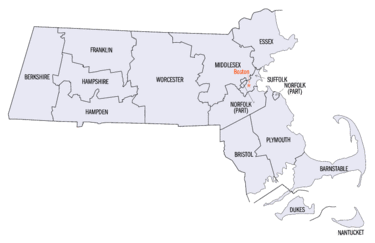
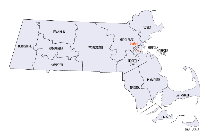
- List of counties in Massachusetts
-
 Massachusetts counties
This is a list of the 14 counties in Massachusetts. Massachusetts has abolished eight[1] of its fourteen county governments, leaving five counties with county-level local government (Barnstable, Bristol, Dukes, Norfolk, Plymouth) and one, Nantucket County, with combined county/city government.[2] Vestigial judicial and law enforcement districts still follow the old county boundaries in the counties where county-level government has been disestablished, and the counties are still generally recognized as geographic entities if not political ones.[3] Three counties have formed new county regional compacts to serve as a form of regional governance, and these include: Hampshire, Barnstable, and Franklin Counties.
Eleven other historical counties have existed in Massachusetts, most becoming defunct when their lands were absorbed into the colony of New Hampshire or the state of Maine, both of which were created out of territory originally claimed by Massachusetts colonists. The oldest counties still in Massachusetts are Essex County, Middlesex County, and Suffolk County, created in 1643 with the original Norfolk County which was absorbed by New Hampshire and bears no relation to the modern Norfolk County. When these counties were created, they were a part of the Massachusetts Bay Colony, which would remain separate from the Plymouth Colony and that colony's counties until 1691. Hampden County, created in 1812, is the most recently created county still in Massachusetts, although Penobscot County, Maine bore that distinction until Maine broke off from Massachusetts in 1820.[4] The majority of Massachusetts counties are named in honor of English place names, reflecting Massachusetts' colonial heritage.[5]
The term shire town is the statutory term for the Massachusetts town having a county court and administration offices; a county can have multiple shire towns.[6] County seat is the standard term used in general communications by the Massachusetts government.
Contents
List of current counties
County FIPS code
[7]County seat
[8][4]Established
[8]Origin
[4]Etymology
[5]Population
[8]Area
[8]Map Barnstable County 001 Barnstable 1685 One of three original counties created in the Plymouth Colony After its county seat of Barnstable, which is named after the English town of Barnstaple 215,888 396 sq mi
(1,026 km2)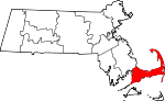
Berkshire County 003 Pittsfield 1761 From part of Hampshire County. Government abolished in 2000.[3] For the English county of Berkshire 131,219 931 sq mi
(2,411 km2)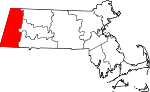
Bristol County 005 Taunton 1685 One of three original counties created in the Plymouth Colony For its original county seat of Bristol, Massachusetts, which is named for the English port city of Bristol - when the Town of Bristol joined Rhode Island, the name of the county was kept 548,285 556 sq mi
(1,440 km2)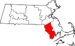
Dukes County 007 Edgartown 1695 From Martha's Vineyard and the Elizabeth Islands, which had been part of Dukes County, New York until Massachusetts gained it in 1691 Formerly a part of Dukes County, New York until 1691, the land at one time was literally the possession of the Duke of York 16,535 104 sq mi
(269 km2)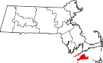
Essex County 009 Salem and Lawrence 1643 One of four original counties created in the Massachusetts Bay Colony. Government abolished in 1999.[3] For the English county of Essex 743,159 498 sq mi
(1,290 km2)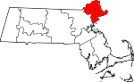
Franklin County 011 Greenfield 1811 From part of Hampshire County. Government abolished in 1997.[3] For Benjamin Franklin (1706–1790), early American scientist, diplomat, and politician 71,372 702 sq mi
(1,818 km2)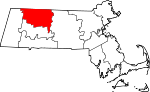
Hampden County 013 Springfield 1812 From part of Hampshire County. Government abolished in 1998.[3] John Hampden (1595—1643), the famous 17th century English parliamentarian 463,490 618 sq mi
(1,601 km2)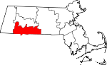
Hampshire County 015 Northampton 1662 From unorganized territory in the western part of the Massachusetts Bay Colony. Government abolished 1999.[3] For the English county of Hampshire 158,080 529 sq mi
(1,370 km2)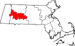
Middlesex County 017 Cambridge and Lowell 1643 One of four original counties created in the Massachusetts Bay Colony. Government abolished in 1997.[3] For the English county of Middlesex 1,503,085 824 sq mi
(2,134 km2)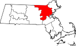
Nantucket County 019 Nantucket 1695 From Nantucket Island which had been part of Dukes County, New York until Massachusetts gained it in 1691. The Town of Nantucket, itself derived from a Wampanoag word meaning "place of peace" 10,172 48 sq mi
(124 km2)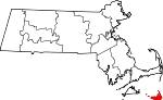
Norfolk County 021 Dedham 1793 From part of Suffolk County. For the English county of Norfolk 670,850 400 sq mi
(1,036 km2)
Plymouth County 023 Plymouth and Brockton 1685 One of three original counties created in the Plymouth Colony. For its seat of Plymouth, which is named for the English port city of Plymouth 494,919 661 sq mi
(1,712 km2)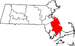
Suffolk County 025 Boston 1643 One of four original counties created in the Massachusetts Bay Colony. Government abolished in 1999.[3] For the English county of Suffolk 722,023 58 sq mi
(150 km2)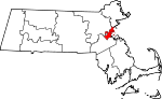
Worcester County 027 Worcester 1731 From parts of Hampshire County, Middlesex County and Suffolk County. Government abolished in 1998.[3] For its county seat of Worcester, which is named in honor of the English city of Worcester and the English Civil War Battle of Worcester in 1651, a Parliamentarian victory 798,552 1,513 sq mi
(3,919 km2)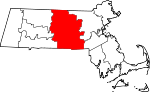
Former counties
County Created
[4]Abolished
[4]Fate
[4]Cumberland County 1760 1820 Transferred to Maine Devonshire County 1674 1675 Abolished Hancock County 1789 1820 Transferred to Maine Kennebec County 1799 1820 Transferred to Maine Lincoln County 1760 1820 Transferred to Maine Old Norfolk County 1643 1679 Abolished - most of its territory was absorbed into New Hampshire; one of four original counties created in the Massachusetts Bay Colony. Oxford County 1805 1820 Transferred to Maine Penobscot County 1816 1820 Transferred to Maine Somerset County 1809 1820 Transferred to Maine Washington County 1789 1820 Transferred to Maine York County 1652 1820 Transferred to Maine - there were two periods when York County was abolished, 1664 to 1668 and 1680 to 1691 References
- ^ "General Laws of Massachusetts, Chapter 34B. Abolition of County Government". Massachusetts General Court. http://www.mass.gov/legis/laws/mgl/gl-34b-toc.htm. Retrieved January 24, 2010.
- ^ "Find a County". National Association of Counties. Archived from the original on 8 June 2007. http://web.archive.org/web/20070608061239/http://www.naco.org/Template.cfm?Section=Find_a_County&Template=/cffiles/counties/state.cfm&statecode=ma. Retrieved 19 July 2007.
- ^ a b c d e f g h i "Historical Data Relating to the Incorporation of and Abolishment of Counties in the Commonwealth of Massachusetts". Secretary of the Commonwealth of Massachusetts. http://www.sec.state.ma.us/cis/cisctlist/ctlistcounin.htm. Retrieved 14 January 2007.
- ^ a b c d e f Brown, Richard and Tager, Jack (2000). Massachusetts: A Concise History. University of Massachusetts Press. ISBN 1558492496.
- ^ a b Beatty, Michael (2001). County Name Origins of the United States. McFarland Press. ISBN 0786410256.
- ^ Part III, Title I, Chapter 213, §7, Massachusetts General Laws. Accessed 24 January 2008.
- ^ "EPA County FIPS Code Listing". EPA.gov. http://www.epa.gov/enviro/html/codes/ma.html. Retrieved 23 February 2008.
- ^ a b c d National Association of Counties. = Find_a_County&Template = /cffiles/counties/state.cfm&state.cfm&statecode = MA "NACo - Find a county". http://www.naco.org/Template.cfm?Section = Find_a_County&Template = /cffiles/counties/state.cfm&state.cfm&statecode = MA. Retrieved 30 April 2008.
See also
- Administrative divisions of Massachusetts
- List of extinct U.S. counties
- Government of Massachusetts - section on local government
External links
- Historical Data Relating to the Incorporation of and Abolishment of Counties in the Commonwealth of Massachusetts, Secretary of the Commonwealth of Massachusetts
 Commonwealth of Massachusetts
Topics Index · Administrative divisions · Congressional districts · Culture · Demographics · Economy · Education · Elections · Geography · Geology · Government · History · Images · Music · People · Politics · Sports · State symbols · Transportation · Villages · Visitor Attractions · Windmills
Regions The Berkshires · Blackstone Valley · Cape Ann · Cape Cod · Central Massachusetts · Greater Boston · The Islands · Merrimack Valley · MetroWest · Montachusett-North County · North Shore · Pioneer Valley · Quabbin Valley · Southeastern Massachusetts · South Coast · South County · South Shore · Western Massachusetts
Counties Cities
(see all
municipalities)Agawam · Amesbury · Attleboro · Barnstable · Beverly · Boston · Braintree · Bridgewater · Brockton · Cambridge · Chelsea · Chicopee · Easthampton · Everett · Fall River · Fitchburg · Franklin · Gardner · Gloucester · Greenfield · Haverhill · Holyoke · Lawrence · Leominster · Lowell · Lynn · Malden · Marlborough · Medford · Melrose · Methuen · New Bedford · Newburyport · Newton · North Adams · Northampton · Palmer · Peabody · Pittsfield · Quincy · Randolph · Revere · Salem · Somerville · Southbridge · Springfield · Taunton · Waltham · Watertown · Westfield · West Springfield · Weymouth · Winthrop · Woburn · Worcester
Note: Municipalities not listed above have a town meeting form of government. Municipalities listed above in italics have a city form of government, but have retained the name prefix "Town of " as part of their official names.Categories:- Lists of U.S. counties by state
- Massachusetts counties
- Massachusetts-related lists
- U.S. county name etymologies


Wikimedia Foundation. 2010.