- Edgartown, Massachusetts
Infobox Settlement
official_name = Edgartown, Massachusetts
nickname =
motto =
imagesize =
image_caption =
image_
mapsize = 250px
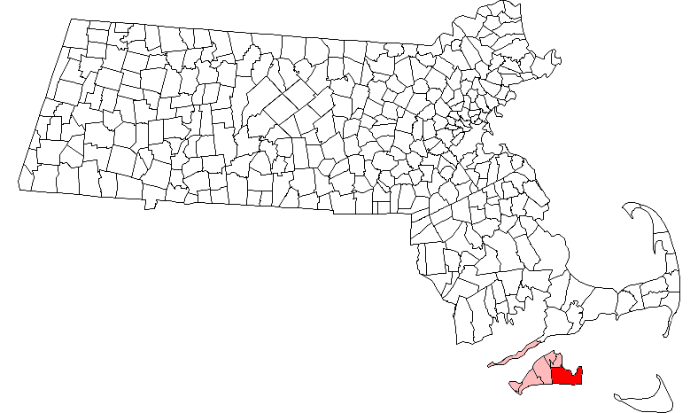
map_caption = Location in Dukes County in Massachusetts
mapsize1 =
map_caption1 =
subdivision_type = Country
subdivision_name =United States
subdivision_type1 = State
subdivision_name1 =Massachusetts
subdivision_type2 = County
subdivision_name2 = Dukes
established_title = Settled
established_date = 1642
established_title2 = Incorporated
established_date2 = 1671
established_title3 =
established_date3 =
government_type =Open town meeting
leader_title =
leader_name =
leader_title1 =
leader_name1 =
area_magnitude =
area_total_km2 = 317.9
area_total_sq_mi = 122.7
area_land_km2 = 69.9
area_land_sq_mi = 27.0
area_water_km2 = 248.0
area_water_sq_mi = 95.8
population_as_of = 2000
settlement_type = Town
population_total = 3779
population_density_km2 = 54.1
population_density_sq_mi = 140.0
elevation_m = 5
elevation_ft = 17
timezone = Eastern
utc_offset = -5
timezone_DST = Eastern
utc_offset_DST = -4
latd = 41 |latm = 23 |lats = 20 |latNS = N
longd = 70 |longm = 30 |longs = 50 |longEW = W
website = [http://www.edgartown-ma.us/ www.edgartown-ma.us]
postal_code_type = ZIP code
postal_code = 02539
area_code = 508 / 774
blank_name = FIPS code
blank_info = 25-21150
blank1_name = GNIS feature ID
blank1_info = 0619441
footnotes =Edgartown is a town located on
Martha's Vineyard in Dukes County,Massachusetts ,United States . The population was 3,779 at the 2000 census. It is thecounty seat of Dukes County.GR|6History
Edgartown was first settled by the English in 1642. Rev. Thomas Mayhew, Jr. led a group of families to start a colony on the island after its purchase by his father
Thomas Mayhew . Originally called Great Harbor, it was incorporated in 1671, and is one of the two original towns on Martha's Vineyard, along with Tisbury. The town's current name is in honor of Edgar, the young son ofJames II of England who died at the age of four in 1671.The younger Mayhew began his work which led to his becoming the first church planting Protestant missionary after he settled in Edgartown. A
Wampanoag Indian namedHiacoomes who lived nearby became his partner in founding the churches in the Indian communities.Edgartown is well known as having been one of the primary ports for the
whaling industry during the 1800s. Ships from all over the world would dock in its sheltered bay and captains would build grand mansions for their families with ornate top floor rooms calledwidow's walk s, which overlooked the harbor. Wives would watch for months from these tiny rooms, hoping to see the sails of ships that would bring their husbands home from the sea.As more economical alternatives became available the whaling industry began to decline. By the beginning of the 20th century, its influence on the tiny town which had made its fortunes through the industry, was ended. Today the town is more known for tourism, as well as the site of Chappaquiddick, where
Ted Kennedy 's infamous incident took place in 1969.Tourism
Edgartown was an old whaling port and is now a summer and tourist destination with a multitude of houses built by whaling captains and other prominent people of prior centuries. The growth of the population over the past 25 years has led to a period of intense renewal of these old houses. Water Street along the harbor is the location of many of these "Captain's Homes" which line both sides of the street. The town has also encouraged renovation of historical structures. As part of this effort, the Whaling Church, a large 18th century church, has been converted to a performing arts center and the adjacent Daniel Fisher House is now used for a variety of social functions. In addition to the architecture of the town, Edgartown is easily traversed on foot or bicycle, making it attractive to tourists.
The Edgartown Light at the end of north Water Street defines the entrance to the Harbor. The harbor is large and entered through a modest sized channel on the North side of Edgartown. It opens into Katama Bay, created by a barrier beach that sometimes connects the south end of Chappaquiddick to the remainder of Edgartown, The barrier beach opened during a spring storm in 2007. This has led to a 3 knot current through Katama Bay and Edgartown Harbor. This protected body of water provides ample mooring for small and large boats. The opening of the harbor will accommodate large sailing and motorized boats, but will not accommodate large ships or yachts which may anchor outside the harbor.
Another feature is South Beach, a small part of the ocean beach that runs the entire southern length of the island from Edgartown to Aquinnah. It can be reached by driving or riding the bus south from Edgartown center for approximately 2.5 miles. South Beach is a crashing ocean beach. It is a major destination for tourists. Much of the beach in Edgartown is open to the public with ample parking available.
Geography
According to the
United States Census Bureau , the town has a total area of 122.7 square miles (317.9 km²), of which, 27.0 square miles (69.9 km²) of it is land and 95.8 square miles (248.0 km²) of it (78.01%) is water. Edgartown is the 103rd out of 351 communities in the Commonwealth by land area, and is the largest town by land area in Dukes County. Edgartown is bordered byNantucket Sound to the northeast and east, theAtlantic Ocean to the south, West Tisbury to the west, and Oak Bluffs to the north. The town also shares a common corner with Tisbury (along with West Tisbury and Oak Bluffs).Edgartown is located at the eastern end of
Martha's Vineyard ("down-island", a vestige of the island's traditional maritime roots in that as a ship travels east, it is said to be traveling "down" east aslongitude decreases towards thePrime Meridian [ [http://www.mvol.com/articles/50/ Articles - Nature - Martha's Vineyard Villages & Towns - Martha's Vineyard Online - The Official Site of Martha's Vineyard ] ] ). The town is closest in proximity to Nantucket's Muskeget Island, which is seven miles east of Wasque Point, the southeastern corner of Chappaquiddick. The town of Edgartown includes the smaller island ofChappaquiddick , sometimes connected to the rest of Martha'a Vineyard only by a barrier beach which can open during storms. Chappaquiddick is separated from the town center by Edgartown Harbor and Katama Bay.Katama is the south central portion of Edgartown. In addition to a spectacular ocean beach, Katama has within its boundaries theKatama Airpark , theKatama Farm , theHerring Creek Farm and 2 resorts.Transportation
Auto transportation is provided by the "On Time" Ferry. A common myth is that the ferry gained its name because it runs continuously from Edgartown center to Chappaquiddick. In actuality, the name comes from the fact that when Jerry Grant purchased the business, it did not come with a ferry. The buzz around town at the time of Grant's purchase was whether or not Grant would have his ferry finished in time for it to make the previous owner's deadline, and not leave Chappaquiddick with a time of no ferry service.. Grant finished his ferry on time, and thus named his ferry the "On Time." Although the On Time I is now gone, Chappaquiddick is currently served by the On Time II and On Time III. Edgartown is home to half of the Manuel F. Correllus State Forest, which spreads into neighboring West Tisbury. There are nine beaches, a yacht club, and several preserves and reservations in the town, including the Wasque Reservation along the south shore of Chappaquiddick and the Cape Pogue Wildlife Refuge along the east shore of the island. There are two lighthouses in the town, at Cape Pogue on Chappaquiddick and the Harbor Light in Edgartown Harbor.
In addition to the "On Time" Ferry, Edgartown is home to another ferry, the "Pied Piper," which runs seasonally between the town and Falmouth. There are two airports in the town.
Katama Airpark is located between Katama Bay and Edgartown Great Pond in the south of town, and serves mostly smaller aircraft. Along the border of the state forest liesMartha's Vineyard Airport , which it shares with West Tisbury. This airport is used more for commercial commuter flights from nearby sites on the mainland and Nantucket.Demographics
As of the
census GR|2 of 2000, there were 3,779 people, 1,582 households, and 957 families residing in the town. Thepopulation density was 140.0 people per square mile (54.1/km²). There were 4,360 housing units at an average density of 161.5/sq mi (62.4/km²). The racial makeup of the town was 93.33% White, 1.77% African American, 0.45% Native American, 0.53% Asian, 0.05% Pacific Islander, 1.53% from other races, and 2.33% from two or more races. Hispanic or Latino of any race were 1.16% of the population.There were 1,582 households out of which 28.3% had children under the age of 18 living with them, 47.7% were married couples living together, 8.6% had a female householder with no husband present, and 39.5% were non-families. 30.1% of all households were made up of individuals and 10.3% had someone living alone who was 65 years of age or older. The average household size was 2.35 and the average family size was 2.92.
In the town the population was spread out with 22.3% under the age of 18, 5.8% from 18 to 24, 30.9% from 25 to 44, 28.3% from 45 to 64, and 12.6% who were 65 years of age or older. The median age was 40 years. For every 100 females there were 102.4 males. For every 100 females age 18 and over, there were 99.2 males.
The median income for a household in the town was $50,407, and the median income for a family was $55,153. Males had a median income of $36,615 versus $30,205 for females. The
per capita income for the town was $25,740. About 2.7% of families and 4.2% of the population were below thepoverty line , including 2.5% of those under age 18 and 1.3% of those age 65 or over.In 2003 the Martha's Vineyard Gazette estimated that there were 15,000 year-round inhabitants of the island with a summer increase to 105,000. Over the last 20 years there has been a continuous growth in the population of the island, although many of the large expanses of undeveloped land and many vistas remain. The summer season, which previously lasted from mid-June through Labor Day weekend has been gradually extended and now includes the period from Memorial Day through Columbus Day.
The town is 260th in terms of population in the Commonwealth, and has the largest population in Dukes County. In terms of population density, Edgartown is 271st in the Commonwealth and third (behind Tisbury and Oak Bluffs) in Dukes County.
Government
On the national level, Edgartown is a part of
Massachusetts's 10th congressional district , and is currently represented byBill Delahunt . The state's senior (Class I) member of theUnited States Senate , re-elected in 2006, isTed Kennedy . The junior (Class II) Senator, up for re-election in 2008, isJohn Kerry .On the state level, Edgartown is represented in the
Massachusetts House of Representatives as a part of the Barnstable, Dukes and Nantucket district, which includes all of Martha's Vineyard and Nantucket, as well as a portion of Falmouth. The town is represented in theMassachusetts Senate as a portion of the Cape and Islands district, which includes all of Martha's Vineyard, Nantucket and most of Barnstable County (with the exception of Bourne, Sandwich, Falmouth and a portion of Barnstable. [ [http://www.mass.gov/legis/citytown.htm Index of Legislative Representatives by City and Town] ] . All of Dukes County is patrolled by the Fifth (Oak Bluffs) Barracks of Troop D of theMassachusetts State Police . [ [http://www.mass.gov/?pageID=eopsterminal&L=5&L0=Home&L1=Law+Enforcement+%26+Criminal+Justice&L2=Law+Enforcement&L3=State+Police+Troops&L4=Troop+D&sid=Eeops&b=terminalcontent&f=msp_divisions_field_services_troops_troop_d_msp_field_troop_d_station_d5&csid=Eeops Station D-5, SP Oak Bluffs] ]Edgartown is governed on the local level by the
open town meeting form of government, and is led by an executive secretary and aboard of selectmen . The town has its own police and fire departments, both located just west of the historic center of town. The current police chief is Paul Condlin. The town has one post office, located further west and south of the wildlife preserve at Sengekontacket Pond. The town's Free Public Library is located in the center of town. Edgartown is also the site of the Dukes County Courthouse, the only courthouse on the island.Education
Edgartown has its own elementary school, which is located on the western edge of the town center and serves approximately 330 students from pre-kindergarten through eighth grade.
Martha's Vineyard Regional High School , located in Oak Bluffs, serves the entire island's high school population. MVRHS's teams are nicknamed the Vineyarders, and their colors are violet and white. The school has a longstanding rivalry with Nantucket High School, with both competing for the Island Cup on an annual basis.See also
*
Edgartown Yacht Club
*Katama
*Katama Airpark References
External links
* [http://www.edgartown-ma.us/ Official Web Site of Edgartown]
* [http://www.edgartowninn.com/ The Edgartown Inn]
* [http://www.edgartownyc.org/ The Edgartown Yacht Club]
* [http://edpublib.vineyard.net/ Edgartown Public Library]
* [http://www.edgartownartgallery.com/ The Edgartown Art Gallery]
* [http://www.police.edgartown.ma.us/ Edgartown Police Department]
* [http://www.edgartownschool.org/ Edgartown School]
* [http://bdweb318928.bluedomino.com Vine Island Builders LLC. - Fine Homes on Martha's Vineyard]
Wikimedia Foundation. 2010.