- Oak Bluffs, Massachusetts
-
"Cottage City" redirects here. For the town in Maryland, see Cottage City, Maryland.
Oak Bluffs, Massachusetts — Town — A row of cottages in the Campground area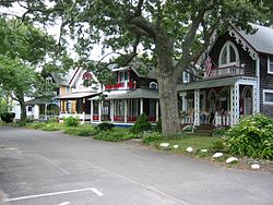 Location in Dukes County in Massachusetts
Coordinates: 41°27′15″N 70°33′45″W / 41.45417°N 70.5625°WCoordinates: 41°27′15″N 70°33′45″W / 41.45417°N 70.5625°W Country United States State Massachusetts County Dukes Settled 1642 Incorporated 1880 Government – Type Open town meeting Area – Total 26.0 sq mi (67.2 km2) – Land 7.4 sq mi (19.1 km2) – Water 18.6 sq mi (48.1 km2) Elevation 30 ft (9 m) Population (2008[1]) – Total 3,735 – Density 504.7/sq mi (195.5/km2) Time zone Eastern (UTC-5) – Summer (DST) Eastern (UTC-4) ZIP code 02557 Area code(s) 508 / 774 FIPS code 25-50390 GNIS feature ID 0619442 Website http://www.oakbluffsma.gov/ Oak Bluffs is a town located on Martha's Vineyard in Dukes County, Massachusetts, United States. The population was 3,713 at the 2000 census and was estimated at 3,735 as of 2008. It is one of two Steamship Authority ferry ports on the island, although the Oak Bluffs steamships only operates in the summer.
Contents
History
Main Article: History of Oak Bluffs
Oak Bluffs was first settled in 1642 and was officially incorporated in 1880 as Cottage City. Before its incorporation, it was part of Edgartown. The town re-incorporated in 1907 as Oak Bluffs, named because the town was the site of an oak grove along the bluffs.Oak Bluffs originally began as the center for tourism on the Vineyard. While the other towns were more focused on industry, Oak Bluffs became a mecca for travelers from around the world as early as the beginning of the 1800s. It also became a center of the thriving 19th century Methodist movement.
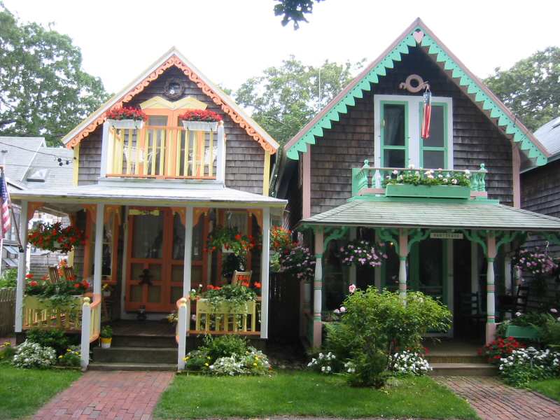
In the area known now as the Martha's Vineyard Campground Meeting Association (MVCMA) or “The Campground“, members of the Methodist church would come each summer to pitch tents and have open air meetings. As these meetings became more and more popular, returning visitors began replacing the tents with small wooden buildings generally known now as Gingerbread Cottages. This name originated from the ornate molding and bright colors that these summer homes were painted and because of their quaint, almost storybook look. With the Methodist camp meetings taking place in the center, the campground expanded in a circular pattern around the meeting area until hundreds of the small cottages sprang up. Later a more permanent structure was built, called the Tabernacle. This covered open sided structure allowed speakers and meeting attendees to weather the elements and gave rise to a community center which is still in use today.
The campground Gingerbread cottages are cherished historic landmarks as well as very expensive real estate. Many are still family owned and passed on generation to generation.
In 1873 the neighboring community of Harthaven was established by William H. Hart when he purchased a lot from the Oak Bluffs Land and Wharf Company. The community later moved in 1911 to its present location between Oak Bluffs town and Edgartown.
In 1884, the Flying Horses Carousel was brought to Oak Bluffs, where it remains the oldest platform carousel still in operation. It was originally on Coney Island, but was moved to Oak Bluffs in 1884. It was built in 1876.
It's a yearly event to what residents call “The Grand Illumination”. This traditional celebration is held once a year, usually in August, and the date of which is usually not publicly disclosed, despite the thousands of tourists the event attracts. For one special night, residents of the Campground place ornate Chinese lanterns (some electric, some still lit with just a candle), around each Gingerbread Cottage. The lanterns remain dark until after dusk. At an appointed hour, people gather in the Tabernacle for a sing-along and community gathering. At the end all the lights go out and thousands of Chinese lanterns spring to life in a brilliant cascade of light throughout the campground. The celebration ends after visitors walk through the Campground enjoying the sights and sounds of an event taken straight from the turn of the century and brought to life yearly in the small town of Oak Bluffs.
On April 5, 2005, the grounds and buildings in the Campground were designated a National Historic Landmark by the Secretary of the Interior.
On November 16, 2006, MTV announced that they were going to make a new TV show called "The Bluffs," about African-Americans going to Oak Bluffs for the summer, but these plans never materialized after vocal public criticism in Island newspapers.
Geography
According to the United States Census Bureau, the town has a total area of 26.0 square miles (67 km2), of which, 7.4 square miles (19 km2) of it is land and 18.6 square miles (48 km2) of it (71.61%) is water. The town is 323rd out of 351 communities in the Commonwealth in terms of land area, and is the third smallest community (behind Aquinnah and Tisbury) in Dukes County. Oak Bluffs is bordered by Nantucket Sound to the north and east, Edgartown to the south, and Vineyard Harbor, Lagoon Pond and Tisbury to the west. It also shares a common corner, along with Tisbury and Edgartown, with West Tisbury.
From the northernmost tip of the town, at East Chop Light, the town is just over five miles from the mainland. The town shares Sengekontacket Pond with Edgartown, with the town's land ending and Sarson's Island, but wrapping around the waters around Felix Neck into Major's Cove. There are four beaches in the town, at Eastville Point (along the lagoon road), the town beach just south of Oak Bluffs Harbor, Harthaven beach and Joseph Sylvia State Beach along the shore opposite Sengekontacket Pond. The highest points in town are between the pond and the lagoon, and west of the lagoon in the irregular triangle of land which juts into Tisbury.
Oak Bluffs is the site of Trade Winds Airport, a private landing strip located just north of the pond, as well as a steamship authority pier for the ferries from Woods Hole, Falmouth Harbor, New Bedford and Hyannis Port. Only the Woods Hole ferry, however, is year round; the others are seasonal only.
Demographics
Historical populations Year Pop. ±% 1880 672 — 1890 1,080 +60.7% 1900 1,100 +1.9% 1910 1,084 −1.5% 1920 1,047 −3.4% 1930 1,333 +27.3% 1940 1,584 +18.8% 1950 1,521 −4.0% 1960 1,419 −6.7% 1970 1,385 −2.4% 1980 1,984 +43.2% 1990 2,804 +41.3% 2000 3,713 +32.4% 2001* 3,776 +1.7% 2002* 3,813 +1.0% 2003* 3,816 +0.1% 2004* 3,814 −0.1% 2005* 3,791 −0.6% 2006* 3,785 −0.2% 2007* 3,797 +0.3% 2008* 3,841 +1.2% 2009* 3,966 +3.3% 2010 4,527 +14.1% * = population estimate. Source: United States Census records and Population Estimates Program data.[2][3][4][5][6][7][8] As of the census[9] of 2000, there were 3,713 people, 1,590 households, and 914 families residing in the town. The population density was 504.1 people per square mile (194.5/km²). There were 3,820 housing units at an average density of 518.6 per square mile (200.1/km²). The racial makeup of the town was 86.72% White, 4.31% African American, 1.51% Native American, 0.67% Asian, 2.50% from other races, and 4.28% from two or more races. Hispanic or Latino of any race were 1.19% of the population.
Like other towns in Southeastern Massachusetts, Oak Bluffs has had a large Portuguese-American population since the late 19th century. Many of these town residents were originally from the island of Faial in the Azores, and the neighborhood where many of them lived, located between Vineyard Avenue and Wing Rd, was once nicknamed Fayal. Today the town's Portuguese heritage is best appreciated at the Annual Portuguese Feast, held at the Portuguese-American Club on Vineyard Avenue in mid-July.
There were 1,590 households out of which 27.7% had children under the age of 18 living with them, 44.3% were married couples living together, 9.4% had a female householder with no husband present, 42.5% were non-families, 32.6% were made up of individuals and 13.0% had someone living alone who was 65 years of age or older. The average household size was 2.33 and the average family size was 2.94.
In the town the population was spread out with 22.6% under the age of 18, 6.0% from 18 to 24, 31.9% from 25 to 44, 24.8% from 45 to 64, and 14.8% who were 65 years of age or older. The median age was 39 years. For every 100 females there were 94.3 males. For every 100 females age 18 and over, there were 93.2 males.
The median income for a household in the town was $42,044, and the median income for a family was $53,841. Males had a median income of $39,113 versus $31,797 for females. The per capita income for the town was $23,829. About 6.2% of families and 8.4% of the population were below the poverty line, including 13.0% of those under age 18 and 8.5% of those age 65 or over.
Oak Bluffs ranks 263rd in population in the Commonwealth of Massachusetts, and third in Dukes County (behind Edgartown and Tisbury). It is 173rd in the Commonwealth of Massachusetts in terms of population density, and second behind Tisbury in Dukes County.
Government
On the national level, Oak Bluffs is a part of Massachusetts's 10th congressional district, and is currently represented by Bill Keating. Massachusetts is currently represented in the United States Senate by Senators John Kerry and Scott Brown.
On the state level, Oak Bluffs is represented in the Massachusetts House of Representatives as a part of the Barnstable, Dukes and Nantucket district, which includes all of Martha's Vineyard and Nantucket, as well as a portion of Falmouth. The town is represented in the Massachusetts Senate as a portion of the Cape and Islands district, which includes all of Martha's Vineyard, Nantucket and most of Barnstable County (with the exception of Bourne, Sandwich, Falmouth and a portion of Barnstable).[10] The town is home to the Fifth Barracks of Troop D of the Massachusetts State Police, which serves all of Dukes County.[11]
Oak Bluffs is governed on the local level by the open town meeting form of government, and is led by a board of selectmen. The town has its own police and fire departments, with the police being located near Oak Bluffs Harbor and the fire department being more centrally located in the town. The post office is located just east of the Vineyard Camp Meeting Association lands, as is Oak Bluffs Public Library, which is a member of the Cape Libraries Automated Materials Sharing library network. Oak Bluffs is also home to Martha's Vineyard Hospital, just northeast of the Lagoon, which serves all of the island, as does the Massachusetts Registry of Motor Vehicles branch near the center of town.
Notable people
Notable residents and former residents of Oak Bluffs:
- Willie Levesque, former professional hockey player drafted by the San Jose Sharks in the 1999 NHL Draft.
- Peter Norton, founder of Peter Norton Computing which developed the Norton Utilities.
- Edward W. Brooke, former Massachusetts US Senator.
Gallery
-
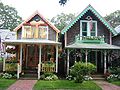
More cottages in the Campground area.
-

Ocean Park gazebo, Oak Bluffs.
See also
- Flying Horses Carousel
- Martha's Vineyard
- Vineyard Haven
- The Grand Illumination
- Harthaven
- History of Oak Bluffs
References
- ^ "City-Data: Oak Bluffs, MA". http://www.city-data.com/city/Oak-Bluffs-Massachusetts.html.
- ^ "TOTAL POPULATION (P1), 2010 Census Summary File 1, All County Subdivisions within Massachusetts". United States Census Bureau. http://factfinder2.census.gov/bkmk/table/1.0/en/DEC/10_SF1/P1/0400000US25.06000. Retrieved September 13, 2011.
- ^ "Massachusetts by Place and County Subdivision - GCT-T1. Population Estimates". United States Census Bureau. http://factfinder.census.gov/servlet/GCTTable?_bm=y&-geo_id=04000US25&-_box_head_nbr=GCT-T1&-ds_name=PEP_2009_EST&-_lang=en&-format=ST-9&-_sse=on. Retrieved July 12, 2011.
- ^ "1990 Census of Population, General Population Characteristics: Massachusetts". US Census Bureau. December 1990. Table 76: General Characteristics of Persons, Households, and Families: 1990. 1990 CP-1-23. http://www.census.gov/prod/cen1990/cp1/cp-1-23.pdf. Retrieved July 12, 2011.
- ^ "1980 Census of the Population, Number of Inhabitants: Massachusetts". US Census Bureau. December 1981. Table 4. Populations of County Subdivisions: 1960 to 1980. PC80-1-A23. http://www2.census.gov/prod2/decennial/documents/1980a_maABC-01.pdf. Retrieved July 12, 2011.
- ^ "1950 Census of Population". Bureau of the Census. 1952. Section 6, Pages 21-10 and 21-11, Massachusetts Table 6. Population of Counties by Minor Civil Divisions: 1930 to 1950. http://www2.census.gov/prod2/decennial/documents/23761117v1ch06.pdf. Retrieved July 12, 2011.
- ^ "1920 Census of Population". Bureau of the Census. Number of Inhabitants, by Counties and Minor Civil Divisions. Pages 21-5 through 21-7. Massachusetts Table 2. Population of Counties by Minor Civil Divisions: 1900, 1910, and 1920. http://www2.census.gov/prod2/decennial/documents/41084506no553ch2.pdf. Retrieved July 12, 2011.
- ^ "1890 Census of the Population". Department of the Interior, Census Office. Pages 179 through 182. Massachusetts Table 5. Population of States and Territories by Minor Civil Divisions: 1880 and 1890. http://www2.census.gov/prod2/decennial/documents/41084506no553ch2.pdf. Retrieved July 12, 2011.
- ^ "American FactFinder". United States Census Bureau. http://factfinder.census.gov. Retrieved 2008-01-31.
- ^ Index of Legislative Representatives by City and Town
- ^ Station D-5, SP Oak Bluffs
External links
- Town of Oak Bluffs
- Martha's Vineyard Camp Meeting Association
- [1] Harthaven Community
Municipalities and communities of Dukes County, Massachusetts Towns 
CDP Other
villageCategories:- Populated coastal places in Massachusetts
- Towns in Dukes County, Massachusetts
- Martha's Vineyard
- Populated places established in 1642


Wikimedia Foundation. 2010.