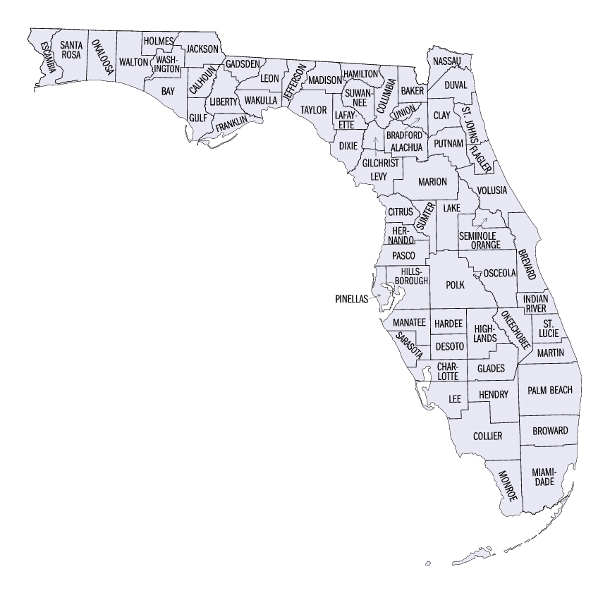
- List of counties in Florida
-
 Florida counties (clickable map)
There are 67 counties in the U.S. state of Florida. It was a territory of the U.S. in 1821 and started with two counties: Escambia to the west and St. Johns to the east, divided by the Apalachicola River. All of the other counties were apportioned from these two original counties. Florida became the 27th U.S. state in 1845, and its last county was created in 1925 with the formation of Gilchrist County from a segment of Alachua County.[1] Florida's counties were originally subdivisions of the state government. In 1968, counties gained the power to develop their own charters.[2]
Most of Florida's counties are named for local or national political leaders. Some are named for Spanish explorers or conquistadors, marking the influence of 200 years of Spanish rule. Natural features of the region, including rivers, lakes, and flora, are also commonly used for county names. Florida has counties named for participants on both sides of Second Seminole War: Miami-Dade County is partially named for Francis L. Dade, a Major in the U.S. Army at the time; Osceola County is named for a Native American resistance leader during the war.[3]
Population figures are based on the 2010 United States Census. The population of Florida is 18,801,310, an increase of 17.6% from 2000. The average population of Florida's counties is 280,616; Miami-Dade County is the most populous (2,496,435) and Liberty County is the least (8,365). The average land area is 805 sq mi (2,085 km2). The largest county is Palm Beach County (2,034 sq mi, 5,268 km2) and the smallest is Union County (240 sq mi, 622 km2). The total area of the state is 65,795 sq miles; of this, the land area of the state constitutes 53,927 square miles (139,670 km2) while the water area constitutes 11,868 sq miles.[4][5]
The Federal Information Processing Standard (FIPS) is used by the U.S. government to uniquely identify counties, and is provided for each entry. These codes link to the United States Census Bureau's "quick facts" for each county. Florida's FIPS code of 12 is used to distinguish from counties in other states. For example, Alachua County's unique nationwide identifier is 12001.[6]
Contents
Counties
County FIPS code
[6]County seat
[7]Established
[3]Formed from
[3]Etymology
[3]Population
[4][7]Area
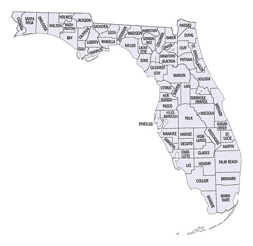
[4][7]Map Alachua County 001 Gainesville 1824 St. Johns County Derived from the native name of a chasm located northwest of Gainesville 247,336 874 sq mi
(2,264 km2)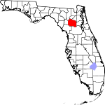
Baker County 003 Macclenny 1861 Bradford County James McNair Baker (1821–1892), a Confederate senator and later a judge in the fourth judicial district 27,115 585 sq mi
(1,515 km2)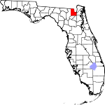
Bay County 005 Panama City 1913 Washington County St. Andrew's Bay, the central geographic feature of the county 168,852 764 sq mi
(1,979 km2)
Bradford County 007 Starke 1858 Columbia and Alachua counties Richard Bradford, the first officer from Florida to die in the Civil War; he was killed during the Battle of Santa Rosa Island 28,520 293 sq mi
(759 km2)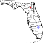
Brevard County 009 Titusville 1844 Orange County Thomas Washington Brevard, early settler and later state comptroller from 1853 to 1861 543,376 1,018 sq mi
(2,637 km2)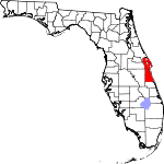
Broward County 011 Fort Lauderdale 1915 Miami-Dade County Napoleon Bonaparte Broward (1857–1910), 19th Governor of Florida from 1905 to 1909 1,748,066 1,209 sq mi
(3,131 km2)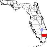
Calhoun County 013 Blountstown 1838 Escambia County John C. Calhoun (1782–1850) leading Southern politician from South Carolina 14,625 567 sq mi
(1,469 km2)
Charlotte County 015 Punta Gorda 1921 DeSoto County Probably a corruption of the name of the Calusa, a group of Native Americans from the area 159,978 694 sq mi
(1,797 km2)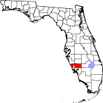
Citrus County 017 Inverness 1887 Hernando County The county's citrus trees 141,236 584 sq mi
(1,513 km2)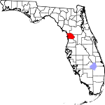
Clay County 019 Green Cove Springs 1858 Duval County Henry Clay (1777–1852), Secretary of State from 1825 to 1829 under John Quincy Adams 190,865 601 sq mi
(1,557 km2)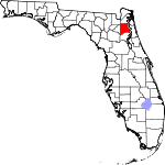
Collier County 021 Naples 1923 Lee County Barron Collier (1873–1939), an advertising entrepreneur who developed much of the land in southern Florida 321,520 2,026 sq mi
(5,247 km2)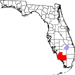
Columbia County 023 Lake City 1832 St. Johns County Christopher Columbus (c. 1451–1506), explorer of the Americas 67,531 797 sq mi
(2,064 km2)
DeSoto County 027 Arcadia 1887 Manatee County Hernando de Soto (c. 1496/1497–1542), a Spanish explorer and conquistador 34,862 637 sq mi
(1,650 km2)
Dixie County 029 Cross City 1921 Lafayette County Dixie, the common nickname for the Southern United States 16,422 704 sq mi
(1,823 km2)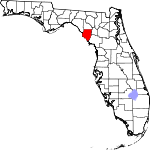
Duval County 031 Jacksonville 1822 St. Johns County William Pope Duval (1784–1854), the first governor of the Florida Territory 864,263 774 sq mi
(2,005 km2)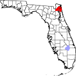
Escambia County 033 Pensacola 1821 One of the two original counties of Florida Disputed origin; possibly from the Native American word Shambia, meaning "clear water" 297,619 664 sq mi
(1,720 km2)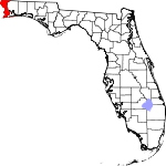
Flagler County 035 Bunnell 1917 St. Johns and Volusia counties Henry Morrison Flagler (1830–1913), founder of the Florida East Coast Railway 95,696 485 sq mi
(1,256 km2)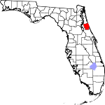
Franklin County 037 Apalachicola 1832 Escambia County Benjamin Franklin (1706–1790), one of the Founding Fathers of the United States of America 11,549 534 sq mi
(1,383 km2)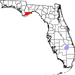
Gadsden County 039 Quincy 1823 Jackson County James Gadsden (1788–1858), American diplomat and namesake of the Gadsden Purchase 46,389 516 sq mi
(1,336 km2)
Gilchrist County 041 Trenton 1925 Alachua County Albert W. Gilchrist (1858–1926), the 20th Governor of Florida 16,939 349 sq mi
(904 km2)
Glades County 043 Moore Haven 1921 DeSoto County The Florida Everglades 12,884 774 sq mi
(2,005 km2)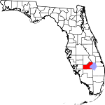
Gulf County 045 Port St. Joe 1925 Calhoun County The Gulf of Mexico 15,863 565 sq mi
(1,463 km2)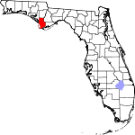
Hamilton County 047 Jasper 1827 Escambia County Alexander Hamilton (1757–1804), the first United States Secretary of the Treasury and a Founding Father 14,799 515 sq mi
(1,334 km2)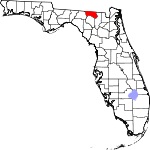
Hardee County 049 Wauchula 1921 DeSoto County Cary A. Hardee (1876–1957), governor of Florida at the time of creation of Hardee County 27,731 637 sq mi
(1,650 km2)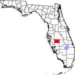
Hendry County 051 La Belle 1923 Lee County Francis A. Hendry (1833–1917), early Floridian pioneer and politician 39,140 1,153 sq mi
(2,986 km2)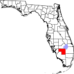
Hernando County 053 Brooksville 1843 Hillsborough, Mosquito, and Alachua counties Hernando de Soto (c.1496/1497–1542), a Spanish explorer and conquistador 172,778 478 sq mi
(1,238 km2)
Highlands County 055 Sebring 1921 DeSoto County Named for the county's hilly terrain 98,786 1,028 sq mi
(2,663 km2)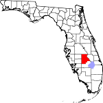
Hillsborough County 057 Tampa 1834 St. Johns County Wills Hill, 1st Marquess of Downshire (1718–1793), former Secretary of State of the American Colonies 1,229,226 1,051 sq mi
(2,722 km2)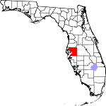
Holmes County 059 Bonifay 1848 Jackson and Walton counties Holmes Creek, which forms the eastern boundary of the county 19,927 482 sq mi
(1,248 km2)
Indian River County 061 Vero Beach 1925 St. Lucie County The Indian River Lagoon, which flows through the county 138,028 503 sq mi
(1,303 km2)
Jackson County 063 Marianna 1822 Escambia County Andrew Jackson (1767–1845), the seventh President of the United States 49,746 916 sq mi
(2,372 km2)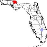
Jefferson County 065 Monticello 1827 Escambia County Thomas Jefferson (1743–1826), the third President of the United States and principal author of the Declaration of Independence 14,761 598 sq mi
(1,549 km2)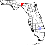
Lafayette County 067 Mayo 1856 Madison County Marquis de Lafayette (1757–1834), French aristocrat and general in the American Revolutionary War 8,870 543 sq mi
(1,406 km2)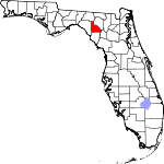
Lake County 069 Tavares 1887 Orange and Sumter counties Named for the many lakes in the region 297,052 953 sq mi
(2,468 km2)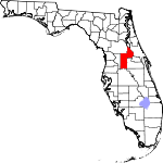
Lee County 071 Fort Myers 1887 Monroe County Robert E. Lee (1807–1870), commander of the Confederate Army of Northern Virginia in the American Civil War 618,754 804 sq mi
(2,082 km2)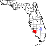
Leon County 073 Tallahassee 1824 Escambia County Juan Ponce de León (1474–1521), Spanish explorer who named Florida 275,487 667 sq mi
(1,728 km2)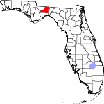
Levy County 075 Bronson 1845 Alachua County David Levy Yulee (1810–1886), one of the state's original United States Senators 40,801 1,118 sq mi
(2,896 km2)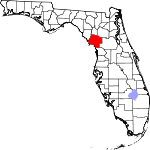
Liberty County 077 Bristol 1855 Gadsden County The patriotic ideal of liberty 8,365 836 sq mi
(2,165 km2)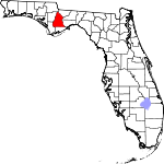
Madison County 079 Madison 1827 Jefferson County James Madison (1751–1836), fourth President of the United States 19,224 692 sq mi
(1,792 km2)
Manatee County 081 Bradenton 1855 Hillsborough and Orange counties The Manatee, or sea cow, is native to Floridian waters 322,833 741 sq mi
(1,919 km2)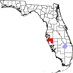
Marion County 083 Ocala 1844 Alachua and Orange counties Francis Marion (c. 1732–1795), military officer during the American Revolution 331,298 1,579 sq mi
(4,090 km2)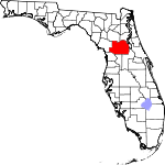
Martin County 085 Stuart 1925 Saint Lucie and Palm Beach counties John W. Martin (1884–1958), governor of Florida at time of creation of the county 146,318 556 sq mi
(1,440 km2)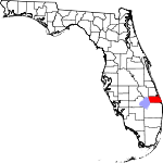
Miami-Dade County 086 Miami 1836 St. Johns County City of Miami and Francis L. Dade (c. 1793–1835), Major in the United States Army during the Second Seminole War 2,496,435 1,945 sq mi
(5,038 km2)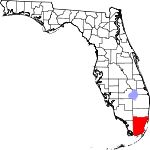
Monroe County 087 Key West 1823 St. Johns County James Monroe (1758–1831), fifth President of the United States 73,090 997 sq mi
(2,582 km2)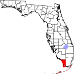
Nassau County 089 Fernandina Beach 1824 St. Johns County Duchy of Nassau in Germany 73,314 652 sq mi
(1,689 km2)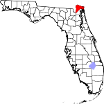
Okaloosa County 091 Crestview 1915 Santa Rosa and Walton counties A native word meaning "a pleasant place," "black water", or "beautiful place" 180,822 936 sq mi
(2,424 km2)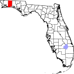
Okeechobee County 093 Okeechobee 1917 Osceola and Brevard counties Lake Okeechobee, which was in turn is from the Hitchiti words for "big water" 39,996 774 sq mi
(2,005 km2)
Orange County 095 Orlando 1824 St. Johns County The fruit that is the county's main product 1,145,956 908 sq mi
(2,352 km2)
Osceola County 097 Kissimmee 1887 Brevard and Orange counties Osceola (1804–1838), a leader of the Seminole during the Second Seminole War 268,685 1,322 sq mi
(3,424 km2)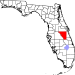
Palm Beach County 099 West Palm Beach 1909 Miami-Dade County The county's large amounts of palm trees 1,320,134 2,034 sq mi
(5,268 km2)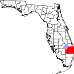
Pasco County 101 Dade City 1887 Hernando County Samuel Pasco (1834–1917), United States Senator at the time of creation of the county 464,697 745 sq mi
(1,930 km2)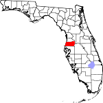
Pinellas County 103 Clearwater 1911 Hillsborough County From the Spanish Punta Piñal, or "Point of Pines" 916,542 280 sq mi
(725 km2)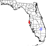
Polk County 105 Bartow 1861 Brevard and Hillsborough counties James K. Polk (1795–1849), the 11th President of the United States 602,095 1,875 sq mi
(4,856 km2)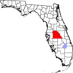
Putnam County 107 Palatka 1849 Alachua and St. Johns counties Benjamin A. Putnam (1801–1869), soldier during the Second Seminole War and Floridian legislator 74,364 722 sq mi
(1,870 km2)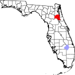
Saint Johns County 109 Saint Augustine 1821 One of the two original counties Name derived from the St. Johns River, which in turn derives its name from San Juan del Puerto 190,039 609 sq mi
(1,577 km2)
Saint Lucie County 111 Fort Pierce 1905 Brevard County Saint Lucy (283–304), the Christian martyr 277,789 572 sq mi
(1,481 km2)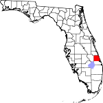
Santa Rosa County 113 Milton 1842 Escambia County Santa Rosa Island, which is in turn named for Saint Rosa de Viterbo (1235–1252), a saint born in Viterbo, Italy 151,372 1,016 sq mi
(2,631 km2)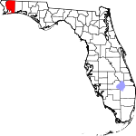
Sarasota County 115 Sarasota 1921 Manatee County Native American word, of uncertain meaning, for the area 379,448 572 sq mi
(1,481 km2)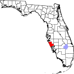
Seminole County 117 Sanford 1913 Orange County The Seminole Native American tribe 422,718 308 sq mi
(798 km2)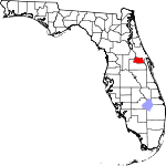
Sumter County 119 Bushnell 1853 Orange County Thomas Sumter (1734–1832), general in the American Revolution 93,420 546 sq mi
(1,414 km2)
Suwannee County 121 Live Oak 1858 Columbia County The Suwannee River, a 266-mile long river in northern Florida 41,551 688 sq mi
(1,782 km2)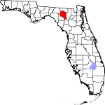
Taylor County 123 Perry 1856 Madison County Zachary Taylor (1784–1850), 12th President of the United States 22,570 1,042 sq mi
(2,699 km2)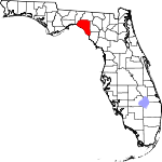
Union County 125 Lake Butler 1921 Bradford County Named for the area's residents united desire to split into a separate county 15,535 240 sq mi
(622 km2)
Volusia County 127 De Land 1854 Orange County The port of Volusia, whose etymology is uncertain; possibly derived from the Native American word for "Land of the Euchees," the term for the area's native inhabitants 494,593 1,106 sq mi
(2,865 km2)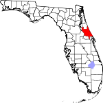
Wakulla County 129 Crawfordville 1843 Leon County The Wakulla River, itself named for a Spanish corruption of a Timucuan word used to describe the body of water, but that is of uncertain meaning 30,776 607 sq mi
(1,572 km2)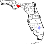
Walton County 131 DeFuniak Springs 1824 Escambia County George Walton, first Secretary of Florida Territory 55,043 1,058 sq mi
(2,740 km2)
Washington County 133 Chipley 1825 Jackson and Walton counties George Washington (1732–1799), first President of the United States 24,896 580 sq mi
(1,502 km2)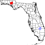
Renamed counties
Five counties in Florida have been renamed. Most renamings occurred between 1845 and 1861, during the first sixteen years of Florida's statehood. One occurred in 1997, when Dade County changed its name to Miami-Dade County.
County[3] Dates[3] Etymology[3] Fate[3] Benton County 1844–1850 Thomas Benton (1782–1858), U.S. Senator from Missouri who supported the Armed Occupation Act of 1842 that many Floridians wanted in order to evict Native Americans Original name of county was Hernando County, and the name was changed back to that in 1850 Dade County 1836–1997 Francis L. Dade (c. 1793–1835), Major in the United States Army during the Second Seminole War Changed to Miami-Dade County in 1997 in order to have a more recognizable name Mosquito County 1824–1845 Taken from the name the Spanish had given the entire coast, "Los Mosquitos" Changed to Orange County in 1845 New River County 1858–1861 The New River Changed to Bradford County in 1861 St. Lucia County 1844–1855 Saint Lucy (283–304), the Christian martyr Changed to Brevard County in 1855 Proposed counties
Two counties were proposed in Florida's state legislature, but neither actually became counties. A bill was passed by the legislature to create Bloxham County, but residents did not vote to approve it. See Leigh Read County, Florida for the events surrounding the proposed county.
County[3] Proposal date[3] Etymology[3] Bloxham County 1914 William D. Bloxham (1835–1911), 13th and 17th Governor of Florida Leigh Read County 1842 Leigh Read, legislator References
- General
- Atlas of Florida, revised edition. Edward A. Fernald & Elizabeth D. Purdum, editors (University Press of Florida, 1996). "Evolution of Counties," pp. 98–99
- Specific
- ^ "A Guide to Alachua County's History". Alachua County Florida. http://www.alachua.fl.us/government/history/?era=2500. Retrieved March 24, 2010.[dead link]
- ^ "About Florida's Counties". Florida Association of Counties. http://www.fl-counties.com/Pages/About_Floridas_Counties.aspx. Retrieved January 20, 2010.
- ^ a b c d e f g h i j k "Florida County Maps". Florida Center for Instructional Technology – University of South Florida. http://fcit.usf.edu/florida/maps/galleries/county/index.htm. Retrieved January 16, 2010.
- ^ a b c "Florida QuickFacts". U.S. Census Bureau. http://quickfacts.census.gov/qfd/maps/florida_map.html. Retrieved April 23, 2008. (2008 Census estimates)
- ^ "Population Estimates". U.S. Census Bureau. December 2009. http://www.census.gov/popest/states/states.html. Retrieved March 13, 2010. (updated 2008 population estimate)
- ^ a b "United States Environmental Protection Agency (EPA) County FIPS Code Listing". United States Environmental Protection Agency. http://www.epa.gov/enviro/html/codes/fl.html. Retrieved April 24, 2008.
- ^ a b c "NACo – Find a county". National Association of Counties. http://www.naco.org/Template.cfm?Section=Find_a_County&Template=/cffiles/counties/state.cfm&state.cfm&statecode=FL. Retrieved April 24, 2008.
List of U.S. counties and county-equivalents
by political division (state / federal district)Alabama · Alaska · Arizona · Arkansas · California · Colorado · Connecticut · Delaware · District of Columbia · Florida · Georgia · Hawaii · Idaho · Illinois · Indiana · Iowa · Kansas · Kentucky · Louisiana · Maine · Maryland · Massachusetts · Michigan · Minnesota · Mississippi · Missouri · Montana · Nebraska · Nevada · New Hampshire · New Jersey · New Mexico · New York · North Carolina · North Dakota · Ohio · Oklahoma · Oregon · Pennsylvania · Rhode Island · South Carolina · South Dakota · Tennessee · Texas · Utah · Vermont · Virginia · Washington · West Virginia · Wisconsin · Wyoming
Categories:- Lists of U.S. counties by state
- Florida counties
- Florida-related lists


Wikimedia Foundation. 2010.