- Wakulla County, Florida
Infobox U.S. County
county = Wakulla County
state = Florida

founded = 11 March 1843
seat =Crawfordville | area_total_sq_mi =736
area_water_sq_mi =36
area percentage = 17.54%
census yr = 2000
pops = 22,863
density_km2 =15
web = www.mywakulla.com|Wakulla County is a
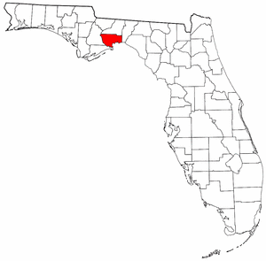
county located in theU.S. state ofFlorida . As of 2000, the population was 22,863. The U.S. Census Bureau 2005 estimate for the county is 28,212 people. [http://www.census.gov/popest/counties/tables/CO-EST2005-01-12.xls] . Itscounty seat is Crawfordville.GR|6Wakulla County is part of the
Tallahassee, Florida Metropolitan Statistical Area.History
panish rule
In 1528,
Panfilo de Narvaez found his way to what would be Wakulla County fromTampa, Florida camping at the confluence of theWakulla River andSt. Marks River . Narvaez would find this a very suitable spot for a fort. In 1539, Hernando de Soto followed with his soldiers establishingSan Marcos de Apalache .Early 19th century
The area to become Wakulla County was an active place in the early 1800s. A former British officer named
William Augustus Bowles attempted to unify and lead 400 Creek Indians against the Spanish outpost of San Marcos capturing it. This provokedSpain and a Spanish flotilla arrived some 5 weeks later and assumed control of San Marcos. In 1818, General Andrew Jackson invaded the territory (Wakulla) taking control of San Marcos. Two captured British citizens,Robert Ambrister and Alexander Arbuthnot, were tried and found guilty of inciting Indian raids and executed causing a diplomatic nightmare between theUnited States andEngland . In 1821, Florida was ceded to the United States and the San Marcos was occupied by U.S. troops. In 1824, the fort was abandoned and turned over to theTerritory of Florida . By 1839, the fort was returned to the U.S. and a federal marine hospital was built. The hospital provided care for victims of yellow fever in the area.Forts of Wakulla County
*1840 - Camp Lawson, northwest of Wakulla and northeast of Ivan, on the St. Marks River. A log stockade also known as Fort Lawson (2).
*1841-1842 - Fort Many located near Wakulla Springs.
*1839 - Fort Number Five (M) located near Sopchoppy.
*1839-1843 - Fort Stansbury was located on theWakulla River 9 miles from St. Marks.
*1841-1843 - Fort Port Leon. Abandoned after a hurricane destroyed it. Site was later used for a CSA gun battery.
*1839 - James Island Post located on James Island. "Source:" Florida Forts [http://www.geocities.com/naforts/flmiddle.html]Antebellum Wakulla
Wakulla County was created in 1843. It may (although this is disputed) be named for the
Timucuan Indian word for "spring of water" or "mysterious water." This is in reference to Wakulla County's greatest natural attraction,Wakulla Springs , which is one of the world's largest freshwater springs, both in terms of depth and water flow. In 1974, the water flow was measured at 1.23 billion gallons per day—the greatest recorded flow ever for a single spring.In an 1856 book, adventurer Charles Lanman wrote of the springs: Quotation|"An adequate idea of this mammoth spring could never be given by pen or pencil; but when once seen, on a bright calm day, it must ever after be a thing to dream about and love. It is the fountain-head of a river... and is of sufficient volume to float a steamboat, if such an affair had yet dared to penetrate this solemn wilderness... It wells up in the very heart of a dense cypress swamp, is nearly round in shape, measures some four hundred feet in diameter, and is in depth about one hundred and fifty feet, having at its bottom an immense horizontal chasm, with a dark portal, from one side of which looms up a limestone cliff, the summit of which is itself nearly fifty feet beneath the spectator, who gazes upon it from the sides of a tiny boat. The water is so astonishlingly clear that even a pin can be seen on the bottom in the deepest places, and of course every animate and inanimate object which it contains is fully exposed to view. The apparent color of the water from the shore is greenish, but as you look prependicularly into it, it is colorless as air, and the sensation of floating upon it is that of being suspended in a balloon; and the water is so refractive, that when the sun shines brilliantly every object you see is enveloped in the most fascinating prismatic hues." Another possible origin for the name Wakulla, not as widely accepted, is that it means "mist" or "misting", perhaps in reference to the
Wakulla Volcano , a 19th century phenomenon in which a column of smoke could be seen emerging from the swamp for miles.Civil War
During the Civil War, Wakulla County was partly involved. From 1861-1865 a Union squadron blockaded the mouth of the St. Marks River. Confederates took the old Spanish fort site known as
San Marcos de Apalache and renamed it Fort Ward. TheBattle of Natural Bridge eventually stopped the Union force that intended to take Fort Ward.Etymology
The name "Wakulla" is corrupted from "Guacara". "Guacara" is a Spanish phonetic spelling of an original Indian name, and "Wakulla" is a
Muskhogean pronunciation of "Guacara". The Spanish "Gua" is the equivalent of the Creek "wa", and as the Creek alphabet does not exhibit an "R" sound, the second element "cara" would have been pronounced "kala" by the Creeks. The Creek voiceless "L" is always substituted for the Spanish "R". Thus the word "Guacara" was pronounced "Wakala" by theSeminoles who are Muskhogean in their origin and language.Since Wakulla was probably a
Timucua n word, it is unlikely that its meaning will ever be known. It may contain the word "kala" which signified a "spring of water" in some Indian dialects. [cite book|last=Simpson|first=J. Clarence|editor=Mark F. Boyd|title=Florida Place-Names of Indian Derivation|publisher=Florida Geological Survey|year=1956|location=Tallahassee, Florida]Geography
According to the U.S. Census Bureau, the county has a total area of 736 square miles (1,906 km²), of which, 607 square miles (1,571 km²) of it is land and 129 square miles (334 km²) of it (17.54%) is water.
Wakulla County is part of the Tallahassee Metropolitan Statistical Area.
Adjacent counties
*
Leon County, Florida - north
*Liberty County, Florida - west
*Franklin County, Florida - south
*Jefferson County, Florida - eastNational
protected area s*
Apalachicola National Forest (part)
*St. Marks National Wildlife Refuge (part)Demographics
As of the
census GR|2 of 2000, there were 22,863 people, 8,450 households, and 6,236 families residing in the county. Thepopulation density was 38 people per square mile (15/km²). There were 9,820 housing units at an average density of 16 per square mile (6/km²). The racial makeup of the county was 86.10% White, 11.51% Black or African American, 0.59% Native American, 0.25% Asian, 0.03% Pacific Islander, 0.29% from other races, and 1.23% from two or more races. 1.94% of the population were Hispanic or Latino of any race.There were 8,450 households out of which 35.60% had children under the age of 18 living with them, 57.10% were married couples living together, 12.40% had a female householder with no husband present, and 26.20% were non-families. 22.00% of all households were made up of individuals and 7.00% had someone living alone who was 65 years of age or older. The average household size was 2.57 and the average family size was 2.99. In the county the population was spread out with 25.60% under the age of 18, 7.60% from 18 to 24, 31.70% from 25 to 44, 24.70% from 45 to 64, and 10.30% who were 65 years of age or older. The median age was 37 years. For every 100 females there were 107.30 males. For every 100 females age 18 and over, there were 106.80 males.
The median income for a household in the county was $37,149, and the median income for a family was $42,222. Males had a median income of $29,845 versus $24,330 for females. The
per capita income for the county was $17,678. About 9.30% of families and 11.30% of the population were below thepoverty line , including 15.40% of those under age 18 and 15.10% of those age 65 or over.Places
Incorporated
* City of Sopchoppy
* City of St. MarksUnincorporated
* Crawfordville
* Medart
* Panacea
* Newport
* Smith Creek
* Shell Point
* Spring CreekWakulla County stands out in one statistical category: there is a near-absence of any municipal population in this county of perhaps 27,000. Two tiny municipalities hold maybe 3 percent of the population. The county seat, Crawfordville, is the only unincorporated county seat among Florida's 67 counties, and, lying only 20 miles from Tallahassee, that district has grown dramatically in recent years to an extraordinarily large and dense population for a "rural" place not touching or having any continuity with any incorporated town. The Crawfordville population center may now have 12-18,000 inhabitants in 10-20 square miles.
Political
County representation
Transportation
Roads
Although there are no
Interstate highway s in Wakulla County, several major routes to pass through the area, includingU.S. Route 98 andU.S. Route 319 . Other important roads in the county include State Road 267, State Road 363 and County Road 375. cite book|year=2003|title=Florida Atlas & Gazetteer|edition=7th|publisher=DeLorme|location=|id=ISBN 0-89933-318-4]Railroads
No railroads currently operate within Wakulla County. In the past the
Georgia, Florida and Alabama Railroad passed through Sopchoppy on its route between Tallahassee and Carrabelle until its abandonment in 1948 cite web|url=http://www.taplines.net/gfa/gfa.html|title=Donald R. Hensley, Jr.'s Taplines|work=The story of the Georgia Florida & Alabama RR|accessdate=2007-01-09] , while theTallahassee-St. Marks Railroad , the first railroad in Florida, was abandoned by theSeaboard Coast Line in 1983.Airports
The
Wakulla County Airport (2J0), located south of Panacea, is a small public-use airport with a single 2600-foot, north-south turf runway. cite web|url=http://www.airnav.com/airport/2J0|title=AirNav, LLC|work=2J0 - Wakulla County Airport|accessdate=2007-01-09]eaports
St. Marks is a small commercial seaport, which in the past was of some minor importance in the oil industry, however it is currently used primarily by commercial fishermen and recreational boaters.Fact|date=February 2007 Panacea and Ochlockonee Bay also support small fishing fleets.
Education
Wakulla County is served by the Wakulla school district with the following schools:
*Crawfordville Elementary School
*Medart Elementary School
*Shadeville Elementary School
*Riversprings Middle School
*Wakulla Middle School
*Wakulla High School References
External links
Government links/constitutional offices
* [http://www.mywakulla.com/ Wakulla County Board of County Commissioners]
* [http://www.wakullahealth.com/ Wakulla County Health Department]
* [http://www.wakullaelection.com/ Wakulla County Supervisor of Elections]
* [http://www.mywakullapa.com/ Wakulla County Property Appraiser]
* [http://www.wcso.org/ Wakulla County Sheriff's Office]
* [http://www.wakullacountytaxcollector.com/default.aspx Wakulla County Tax Collector]
* [http://www.wakullaclerk.com/ Wakulla Clerk of the Courts ]pecial districts
* [http://www.wakullaschooldistrict.org/ Wakulla County Schools]
* [http://sun6.dms.state.fl.us/nwfwmd/ Northwest Florida Water Management District]Judicial branch
* [http://www.wakullaclerk.com/ Wakulla County Clerk of Courts]
* [http://www.co.leon.fl.us/PD/index.asp Public Defender, 2nd Judicial Circuit of Florida] serving Florida, Gadsden, Jefferson, Leon, Liberty, and Wakulla counties
* [http://www.sao2fl.org/ Office of the State Attorney, 2nd Judicial Circuit of Florida]
* [http://www.2ndcircuit.leon.fl.us/ Circuit and County Court for the 2nd Judicial Circuit of Florida]Other links
* [http://www.wakullacountychamber.com/ Wakulla County Chamber of Commerce]
Sources
* [http://www.geocities.com/naforts/flmiddle.html Florida forts]
Wikimedia Foundation. 2010.