- Gulf of Mexico
-
 The Gulf of Mexico in 3D perspective

Earth's oceans
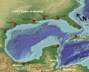
(World Ocean)The Gulf of Mexico (Spanish: Golfo de México) is a partially landlocked[1] ocean basin largely surrounded by the North American continent and the island of Cuba.[2] It is bounded on the northeast, north and northwest by the Gulf Coast of the United States, on the southwest and south by Mexico, and on the southeast by Cuba. In Texas and Louisiana it is often called the "Third Coast," in comparison with the US Atlantic and Pacific coasts. The shape of its basin is roughly oval and is approximately 810 nautical miles (1,500 km) wide and filled with sedimentary rocks and debris. It is connected to the Atlantic Ocean through the Florida Straits between the U.S. and Cuba, and with the Caribbean Sea (with which it forms the American Mediterranean Sea) via the Yucatan Channel between Mexico and Cuba. With this narrow connection to the Atlantic, the Gulf experiences very small tidal ranges. The size of the Gulf basin is approximately 615,000 mi² (1.6 million km²). Almost half of the basin is shallow continental shelf waters. At its deepest it is 14,383 ft (4,384 m) at the Sigsbee Deep, an irregular trough more than 300 nautical miles (560 km) (550 km) long. The basin contains a volume of roughly 660 quadrillion gallons (2.5 × 10⁶ km3). It was probably formed approximately 300 million years ago as a result of the seafloor sinking.[3]
Contents
Extent
The International Hydrographic Organization defines the southeast limit of the Gulf of Mexico as follows:[4]
A line joining Cape Catoche Light (21°37′N 87°04′W / 21.617°N 87.067°W) with the Light on Cape San Antonio in Cuba, through this island to the meridian of 83°W and to the Northward along this meridian to the latitude of the South point of the Dry Tortugas (24°35'N), along this parallel Eastward to Rebecca Shoal (82°35'W) thence through the shoals and Florida Keys to the mainland at eastern end of Florida Bay, all the narrow waters between the Dry Tortugas and the mainland being considered to be within the Gulf.
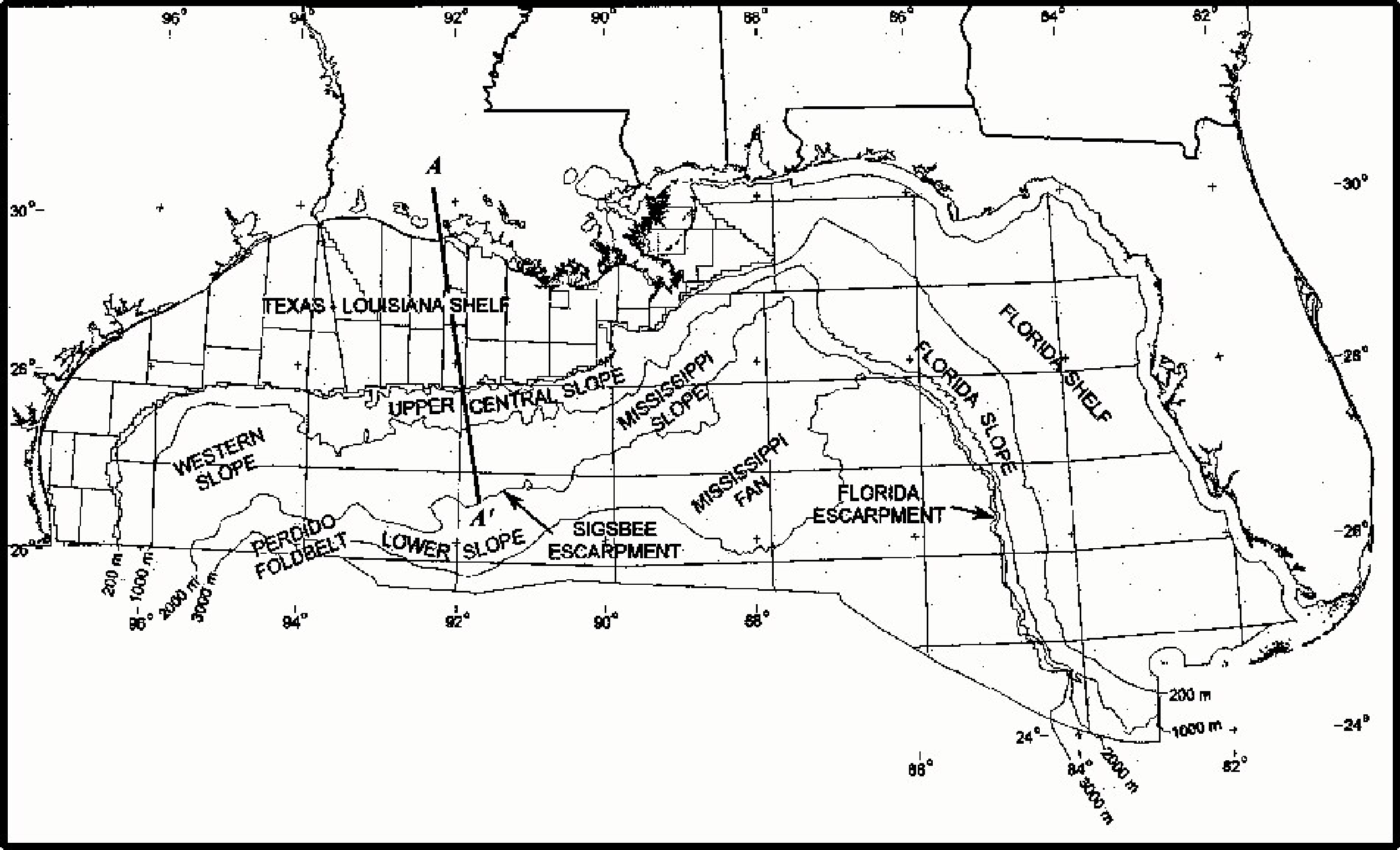
Geology
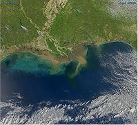 Sediment in the Gulf of Mexico
The consensus among geologists [5][6][7] who have studied the geology of the Gulf of Mexico is that prior to Late Triassic, the Gulf of Mexico did not exist. Before the Late Triassic, the area now occupied by the Gulf of Mexico consisted of dry land, which included continental crust that now underlies Yucatan, within the middle of the large supercontinent of Pangea. This land lay south of a continuous mountain range that extended from north-central Mexico, through the Marathon Uplift in West Texas and the Ouachita Mountains of Oklahoma, and to Alabama where it linked directly to the Appalachian Mountains. It was created by the collision of continental plates that formed Pangea. As interpreted by Roy Van Arsdale and Randel T. Cox, this mountain range was breached in Late Cretaceous times by the formation of the Mississippi Embayment.[6][8]
Geologists and other Earth scientists agree in general that the present Gulf of Mexico basin originated in Late Triassic time as the result of rifting within Pangea. The rifting was associated with zones of weakness within Pangea, including sutures where the Laurentia, South American, and African plates collided to create it. First, there was a Late Triassic-Early Jurassic phase of rifting during which rift valleys formed and filled with continental red beds. Second, as rifting progressed through Early and Middle Jurassic time, continental crust was stretched and thinned. This thinning created a broad zone of thick transitional crust, which displays modest and uneven thinning with block faulting, and a broad zone of uniformly thinned transitional crust, which is half the typical thickness, 35 kilometers, of normal continental crust. It was at this time that tectonics first created a connection to the Pacific Ocean across central Mexico and later eastward to the Atlantic Ocean. This flooded the subsiding basin created by rifting and crustal thinning to create the Gulf of Mexico. While the Gulf of Mexico was a restricted basin, the subsiding transitional crust was blanketed by the widespread deposition of Louann Salt and associated anhydrite evaporites. Initially, during the Late Jurassic, continued rifting widened the Gulf of Mexico and progressed to the point that sea-floor spreading and formation of oceanic crust occurred. At this point, sufficient circulation with the Atlantic Ocean was established that the deposition of Louann Salt ceased.[5][7][9][10]
During the Late Jurassic through Early Cretaceous, the basin occupied by the Gulf of Mexico experience a period of cooling and subsidence of the crust underlying it. The subsidence was the result of a combination of crustal stretching, cooling, and loading. Initially, the combination of crustal stretching and cooling caused about 5–7 km of tectonic subsidence of the central thin transitional and oceanic crust. Because subsidence occurred faster than sediment could fill it, the Gulf of Mexico expanded and deepened.[5][10][11]
Later, loading of the crust within the Gulf of Mexico and adjacent coastal plain by the accumulation of kilometers of sediments during the rest of the Mesozoic and all of the Cenozoic further depressed the underlying crust to its current position about 10–20 km below sea level. Particularly during the Cenozoic, thick clastic wedges built out the continental shelf along the northwestern and northern margins of the Gulf of Mexico.[5][10][11]
To the east, the stable Florida platform was not covered by the sea until the latest Jurassic or the beginning of Cretaceous time. The Yucatan platform was emergent until the mid-Cretaceous. After both platforms were submerged, the formation of carbonates and evaporites has characterized the geologic history of these two stable areas. Most of the basin was rimmed during the Early Cretaceous by carbonate platforms, and its western flank was involved during the latest Cretaceous and early Tertiary in a compressive deformation episode, the Laramide Orogeny, which created the Sierra Madre Oriental of eastern Mexico.[12]
In 2002 geologist Michael Stanton published a speculative essay suggesting an impact origin for the Gulf of Mexico at the close of the Permian, which could have caused the Permian–Triassic extinction event.[13] However, Gulf Coast geologists do not regard this hypothesis as having any credibility. Instead they overwhelmingly accept plate tectonics, not an asteroid impact, as having created the Gulf of Mexico as illustrated by papers authored by Kevin Mickus and others.[7][10][14] This hypothesis is not to be confused with the Chicxulub Crater, a large impact crater on the coast of the Gulf of Mexico on the Yucatan Peninsula.
Today, there are 7 main areas of the gulf:[12]
- Gulf of Mexico Basin, which contains the Sigsbee Deep and can be further divided into the continental rise, the Sigsbee Abyssal Plain, and the Mississippi Cone.
- Northeast Gulf of Mexico, which extends from just east of the Mississippi Delta near Biloxi to the eastern side of Apalachee Bay.
- South Florida Continental Shelf and Slope, which extends along the coast from Apalachee Bay to the Straits of Florida and includes the Florida Keys and Dry Tortugas.
- Campeche Bank, which extends from the Yucatan Straits in the east to the Tabasco–Campeche Basin in the west and includes Arrecife Alacran.
- Bay of Campeche, which is an isthmian embayment extending from the western edge of Campeche Bank to the offshore regions just east of the port of Veracruz.
- Western Gulf of Mexico, which is located between Veracruz to the south and the Rio Grande to the north.
- Northwest Gulf of Mexico, which extends from Alabama to the Rio Grande.
History
European exploration
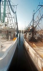 Fishing boats in Biloxi
Although Christopher Columbus was credited with the discovery of the Americas by Europeans, the ships in his four voyages never reached the Gulf of Mexico. Instead, Columbus sailed into the Caribbean around Cuba and Hispaniola. The first European exploration of the Gulf of Mexico was by Amerigo Vespucci in 1497. He followed the coastal land mass of Central America before returning to the Atlantic Ocean via the Straits of Florida between Florida and Cuba. In his letters, Vespucci described this trip, and once Juan de la Cosa returned to Spain, a famous world map, depicting Cuba as an island, was produced.
In 1506, Hernán Cortés took part in the conquest of Hispaniola and Cuba, receiving a large estate of land and Indian slaves for his effort. In 1510, he accompanied Diego Velázquez de Cuéllar, an aide of the governor of Hispaniola, in his expedition to conquer Cuba. In 1518 Velázquez put him in command of an expedition to explore and secure the interior of Mexico for colonization.
In 1517, Francisco Hernández de Córdoba discovered the Yucatán Peninsula. This was the first European encounter with an advanced civilization in the Americas, with solidly built buildings and a complex social organization which they recognized as being comparable to those of the Old World; they also had reason to expect that this new land would have gold. All of this encouraged two further expeditions, the first in 1518 under the command of Juan de Grijalva, and the second in 1519 under the command of Hernán Cortés, which led to the Spanish exploration, military invasion, and ultimately settlement and colonization known as the Conquest of Mexico. Hernández did not live to see the continuation of his work: he died in 1517, the year of his expedition, as the result of the injuries and the extreme thirst suffered during the voyage, and disappointed in the knowledge that Diego Velázquez had given precedence to Grijalva as the captain of the next expedition to Yucatán.
In 1523, Ángel de Villafañe sailed toward Mexico City, but was shipwrecked en route along the coast of Padre Island, Texas, in 1554. When word of the disaster reached Mexico City, the viceroy requested a rescue fleet and immediately sent Villafañe marching overland to find the treasure-laden vessels. Villafañe traveled to Pánuco and hired a ship to transport him to the site, which had already been visited from that community. He arrived in time to greet García de Escalante Alvarado (a nephew of Pedro de Alvarado), commander of the salvage operation, when Alvarado arrived by sea on July 22, 1554. The team labored until September 12 to salvage the Padre Island treasure. This loss, in combination with other ship disasters around the Gulf of Mexico, gave rise to a plan for establishing a settlement on the northern Gulf Coast to protect shipping and more quickly rescue castaways. As a result, the expedition of Tristán de Luna y Arellano was sent and landed at Pensacola Bay on August 15, 1559.
On December 11, 1526, Charles V granted Pánfilo de Narváez a license to claim what is now the Gulf Coast of the United States, known as the Narváez expedition. The contract gave him one year to gather an army, leave Spain, be large enough to found at least two towns of 100 people each, and garrison two more fortresses anywhere along the coast. On April 7, 1528, they spotted land north of what is now Tampa Bay. They turned south and traveled for two days looking for a great harbor the master pilot Miruelo knew of. Sometime during these two days, one of the five remaining ships was lost on the rugged coast, but nothing else is known of it.
In 1697, Pierre Le Moyne d'Iberville sailed for France and was chosen by the Minister of Marine to lead an expedition to rediscover the mouth of the Mississippi River and to colonize Louisiana which the English coveted. Iberville's fleet sailed from Brest on October 24, 1698. On January 25, 1699, Iberville reached Santa Rosa Island in front of Pensacola founded by the Spanish; he sailed from there to Mobile Bay and explored Massacre Island, later renamed Dauphin Island. He cast anchor between Cat Island and Ship Island; and on February 13, 1699, he went to the mainland, Biloxi, with his brother Jean-Baptiste Le Moyne de Bienville.[15] On May 1, 1699, he completed a fort on the north-east side of the Bay of Biloxi, a little to the rear of what is now Ocean Springs, Mississippi. This fort was known as Fort Maurepas or Old Biloxi. A few days later, on May 4, Pierre Le Moyne sailed for France leaving his teenage brother, Jean-Baptiste Le Moyne, as second in command to the French commandant.
Geography
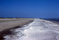 Gulf beach near Sabine Pass
 Map of northern part of Gulf of Mexico
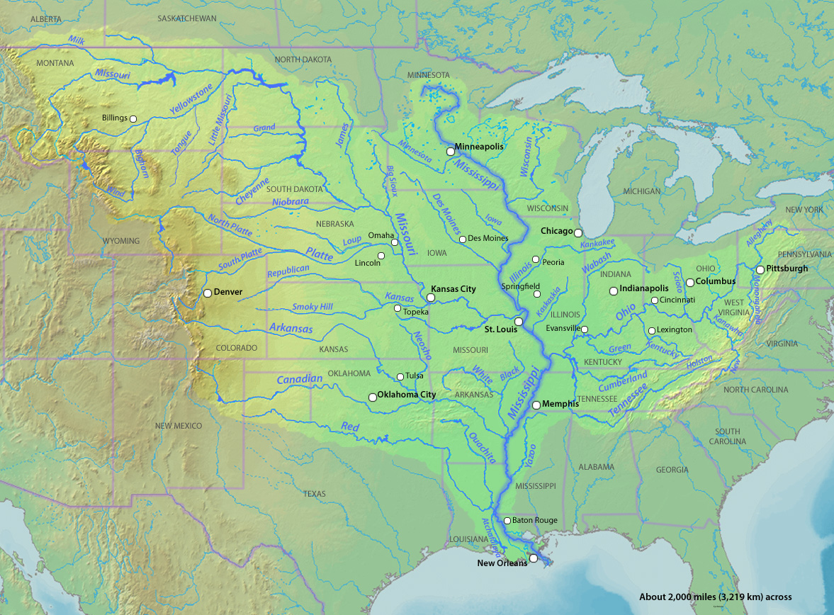
The Gulf of Mexico's eastern, northern, and northwestern shores lie along the US states of Florida, Alabama, Mississippi, Louisiana, and Texas. The US portion of the Gulf coastline spans 1,680 miles (2,700 km), receiving water from thirty-three major rivers that drain 31 states.[17] The Gulf's southwestern and southern shores lie along the Mexican states of Tamaulipas, Veracruz, Tabasco, Campeche, Yucatán, and the northernmost tip of Quintana Roo. The Mexican portion of the Gulf coastline spans 1,394 miles (2,243 km). On its southeast quadrant the Gulf is bordered by Cuba. It supports major American, Mexican and Cuban fishing industries. The outer margins of the wide continental shelves of Yucatán and Florida receive cooler, nutrient-enriched waters from the deep by a process known as upwelling, which stimulates plankton growth in the euphotic zone. This attracts fish, shrimp, and squid.[1] River drainage and atmospheric fallout from industrial coastal cities also provide nutrients to the coastal zone.
The Gulf Stream, a warm Atlantic Ocean current and one of the strongest ocean currents known, originates in the gulf, as a continuation of the Caribbean Current-Yucatán Current-Loop Current system. Other circulation features include the anticyclonic gyres which are shed by the Loop Current and travel westward where they eventually dissipate, and a permanent cyclonic gyre in the Bay of Campeche. The Bay of Campeche in Mexico constitutes a major arm of the Gulf of Mexico. Additionally, the gulf's shoreline is fringed by numerous bays and smaller inlets. A number of rivers empty into the gulf, most notably the Mississippi and Rio Grande rivers in the northern gulf, and the Grijalva and Usumacinta rivers in the southern gulf. The land that forms the gulf's coast, including many long, narrow barrier islands, is almost uniformly low-lying and is characterized by marshes and swamps as well as stretches of sandy beach.
The Gulf of Mexico is an excellent example of a passive margin. The continental shelf is quite wide at most points along the coast, most notably at the Florida and Yucatán Peninsulas. The shelf is exploited for its oil by means of offshore drilling rigs, most of which are situated in the western gulf and in the Bay of Campeche. Another important commercial activity is fishing; major catches include red snapper, amberjack, tilefish, swordfish, and various grouper, as well as shrimp and crabs. Oysters are also harvested on a large scale from many of the bays and sounds. Other important industries along the coast include shipping, petrochemical processing and storage, military use, paper manufacture, and tourism.
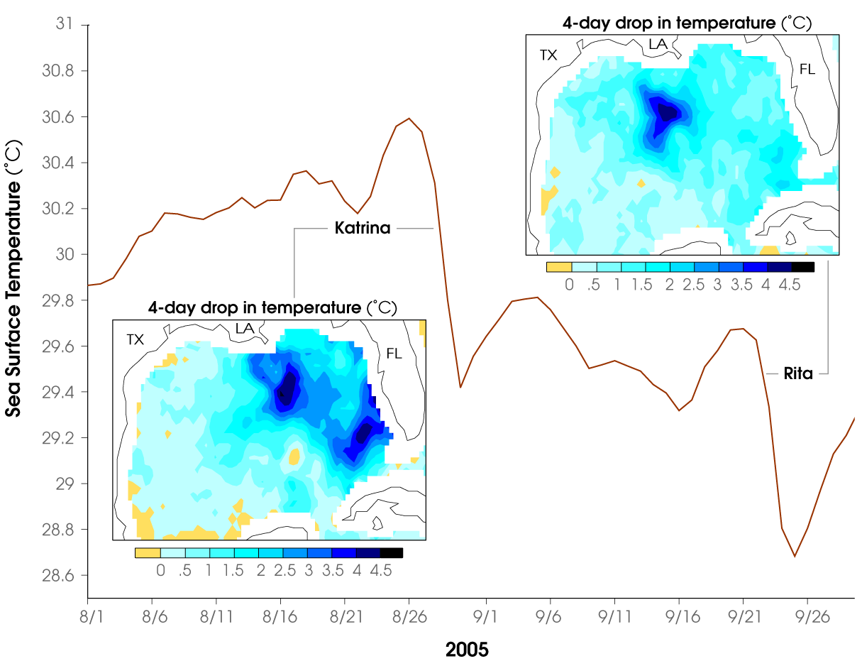
The gulf's warm water temperature can feed powerful Atlantic hurricanes causing extensive human death and other destruction as happened with Hurricane Katrina in 2005. In the Atlantic, a hurricane will draw up cool water from the depths and making it less likely that further hurricanes will follow in its wake (warm water being one of the preconditions necessary for their formation). However, the Gulf is shallower; when a hurricane passes over the water temperature may drop but it soon rebounds and becomes capable of supporting another tropical storm.[18]
The Gulf is considered aseismic; however, mild tremors have been recorded throughout history (usually 5.0 or less on the Richter scale). Earthquakes may be caused by interactions between sediment loading on the sea floor and adjustment by the crust.[19]
2006 earthquake
Main article: 2006 Gulf of Mexico earthquakeOn September 10, 2006, the U.S. Geological Survey National Earthquake Information Center reported that a strong earthquake, ranking 6.0 on the Richter scale, occurred about 250 miles (400 km) west-southwest of Anna Maria, Florida, around 10:56 AM EDT. The quake was reportedly felt from Louisiana to Florida in the Southeastern United States. There were no reports of major damages, injuries or casualties.[20][21] Items were knocked from shelves and seiches were observed in swimming pools in parts of Florida.[22] The earthquake was described by the USGS as a midplate earthquake, the largest and most widely felt recorded in the past three decades in the region.[22] According to the September 11, 2006 issue of The Tampa Tribune, earthquake tremors were last felt in Florida in 1952, recorded in Quincy, 20 miles (32 km) northwest of Tallahassee.
Maritime boundary delimitation agreements
Cuba and Mexico: Exchange of notes constituting an agreement on the delimitation of the exclusive economic zone of Mexico in the sector adjacent to Cuban maritime areas (with map), of July 26, 1976.
Cuba and United States of America: Maritime boundary agreement between the United States of America and the Republic of Cuba, of December 16, 1977.
Mexico and United States of America: Treaty to resolve pending boundary differences and maintain the Rio Grande and Colorado river as the international boundary, of November 23, 1970; Treaty on maritime boundaries between the United States of America and the United Mexican States (Caribbean Sea and Pacific Ocean), of May 4, 1978, and Treaty between the Government of the United States of America and the Government of the United Mexican States on the delimitation of the continental shelf in the Western Gulf of Mexico beyond 200 nautical miles (370 km), of June 9, 2000.

 Texas
Texas United States
 Louisiana •
  Mississippi •
  Alabama
 Florida
 Mexico
 Tamaulipas
Atlantic Ocean  Gulf of Mexico

 Veracruz Mexico
 Tabasco •
  Campeche •
  Yucatán •
  Quintana Roo
 Cuba
Cuba
Caribbean SeaBiota
Main article: Cold seep#Discoveries in the Gulf of MexicoVarious biota include chemosynthetic communities near cold seeps and nonchemosynthetic communities such as bacteria and other microbenthos, meiofauna, macrofauna, and megafauna (larger organisms such as crabs, sea pens, crinoids, and demersal fish and cetaceans including endangered ones) are living in the Gulf of Mexico.[23] The Gulf of Mexico yields more finfish, shrimp, and shellfish annually than the south and mid-Atlantic, Chesapeake, and New England areas combined.[3]
The Smithsonian Institution Gulf of Mexico holdings are expected to provide an important baseline of understanding for future scientific studies on the impact of the Deepwater Horizon oil spill.[24] In Congressional testimony, Dr. Jonathan Coddington, Associate Director of Research and Collections at the Smithsonian’s National Museum of Natural History, provides a detailed overview of the Gulf collections and their sources which Museum staff have made available on an online map. The samples were collected for years by the former Minerals Management Service (renamed the Bureau of Ocean Energy Management, Regulation and Enforcement) to help predict the potential impacts of future oil/gas explorations. Since 1979, the specimens have been deposited in the national collections of the National Museum of Natural History.[25]
Pollution
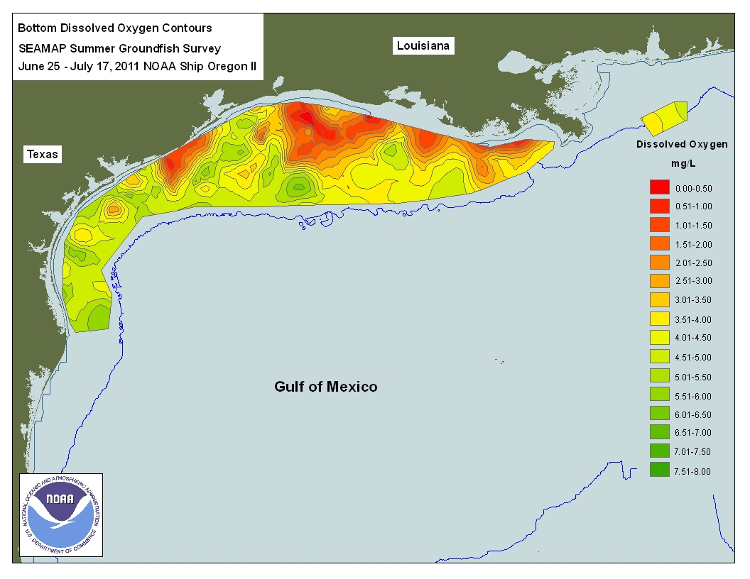
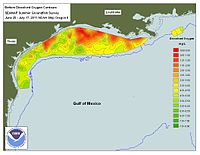 Dead zone in the Gulf of Mexico
There are frequent "red tide" algae blooms[26] that kill fish and marine mammals and cause respiratory problems in humans and some domestic animals when the blooms reach close to shore. This has especially been plaguing the southwest and southern Florida coast, from the Florida Keys to north of Pasco County, Florida.
The Gulf contains a hypoxic dead zone that runs east-west along the Texas-Louisiana coastline. In July 2008, researchers reported that between 1985 and 2008, the area roughly doubled in size and now stretches from near Galveston, Texas, to near Venice, Louisiana. It is now about 8,000 square miles (21,000 km2), nearly the record.[27]
There are 27,000 abandoned oil and gas wells beneath the Gulf. These have generally not been checked for potential environmental problems.[28]
Ixtoc I explosion and oil spill
Main articles: Ixtoc I and Ixtoc I oil spillIn June 1979, the Ixtoc I oil platform in the Bay of Campeche suffered a blowout leading to a catastrophic explosion, which resulted in a massive oil spill that continued for nine months before the well was finally capped. This was ranked as the largest oil spill in the Gulf of Mexico until the Deepwater Horizon oil spill in 2010.
Deepwater Horizon explosion and oil spill
Main articles: Deepwater Horizon explosion and Deepwater Horizon oil spillOn April 20, 2010, the Deepwater Horizon oil platform, located in the Mississippi Canyon about 40 miles (64 km) off the Louisiana coast, suffered a catastrophic explosion; it sank a day-and-a-half later.[29] It was in the process of being sealed with cement for temporary abandonment, to avoid environmental problems.[28] Although initial reports indicated that relatively little oil had leaked, by April 24, it was claimed by BP that approximately 1,000 barrels (160 m3) of oil per day were issuing from the wellhead, about 1-mile (1.6 km) below the surface on the ocean floor.[30] On April 29, the U.S. government revealed that approximately 5,000 barrels (790 m3) per day, five times the original estimate, were pouring into the Gulf from the wellhead.[31] The resulting oil slick quickly expanded to cover hundreds of square miles of ocean surface, posing a serious threat to marine life and adjacent coastal wetlands, and to the livelihoods of Gulf Coast shrimpers and fishermen.[32] Coast Guard Rear Adm. Sally Brice O’Hare stated that the U.S. government will be “employing booms, skimmers, chemical dispersants and controlled burns” to combat the oil spill. As of May 1, 2010, the oil spill cleanup efforts are underway, but hampered by rough seas and the "tea like" consistency of the oil. As of May 27, 2010, USGS had revised the estimate of the leak from 5,000 barrels per day (790 m3/d) to 12,000–19,000 barrels per day (3,000 m3/d)[33] and estimates continue to increase. On July 15, 2010, BP announced that the leak stopped for the first time in 88 days.
See also
- Brine pool
- Charlotte Harbor Estuary, Florida
- Gulf Coast
- Gulf of Mexico Foundation
- Hypoxia
- Jack 2 (a test well in the deep waters of the Gulf of Mexico)
- Orca Basin
- Outer Continental Shelf
- Territorial evolution of the Caribbean
US Gulf of Mexico Protraction areas
- Atwater Valley
- East Cameron
- Eugene Island
- Garden Banks
- Green Canyon
- Keathley Canyon
- Mississippi Canyon
- Sigsbee Escarpment
- South Marsh Island
- Walker Ridge
References
- ^ a b "Gulf of Mexico". Handbook of Texas Online. Texas State Historical Association. http://www.tshaonline.org/handbook/online/articles/GG/rrg7.html. Retrieved June 26, 2010.
- ^ "Gulf of Mexico". Geographic Names Information System. January 1, 2000. http://geonames.usgs.gov/pls/gnispublic/f?p=gnispq:3:::NO::P3_FID:558730. Retrieved July 8, 2010.
- ^ a b "General Facts about the Gulf of Mexico". http://www.epa.gov/gmpo/about/facts.html. Retrieved December 27, 2006.
- ^ "Limits of Oceans and Seas, 3rd edition". International Hydrographic Organization. 1953. http://www.iho-ohi.net/iho_pubs/standard/S-23/S23_1953.pdf. Retrieved February 7, 2010.
- ^ a b c d Salvador, A. (1991) Origin and development of the Gulf of Mexico basin, in A. Salvador, ed., p. 389-444, The Gulf of Mexico Basin: The Geology of North America, v. J., Geological Society of America, Boulder, Colorado.
- ^ a b Van Arsdale, R. B. (2009) Adventures Through Deep Time: The Central Mississippi River Valley and Its Earthquakes. Special Paper no. 455, Geological Society of America, Boulder, Colorado. 107 pp.
- ^ a b c Stern, R.J., and W.R. Dickinson (2010) The Gulf of Mexico is a Jurassic backarc basin. Geosphere. 6(6):739-754.
- ^ Cox, R. T., and R. B. Van Arsdale (2002) The Mississippi Embayment, North America: a first order continental structure generated by the Cretaceous superplume mantle event. Journal of Geodynamics. 34:163–176.
- ^ Buffler, R. T., 1991, Early Evolution of the Gulf of Mexico Basin, in D. Goldthwaite, ed., pp. 1-15, Introduction to Central Gulf Coast Geology, New Orleans Geological Society, New Orleans, Louisiana.
- ^ a b c d Galloway, W. E., 2008, Depositional evolution of the Gulf of Mexico sedimentary basin. in K.J. Hsu, ed., pp. 505-549, The Sedimentary Basins of the United States and Canada, Sedimentary Basins of the World. v. 5, Elsevier, The Netherlands.
- ^ a b Sawyer, D. S., R. T. Buffler, and R. H. Pilger, Jr., 1991, The crust under the Gulf of Mexico basin, in A. Salvador, ed., pp. 53-72, The Gulf of Mexico Basin: The Geology of North America, v. J., Geological Society of America, Boulder, Colorado.
- ^ a b gulfbase.org
- ^ Stanton, M. S., 2002, Is the Gulf's Origin Heaven Sent? AAPG Explorer (Dec. 2002) American Association of Petroleum Geologists. Tulsa Oklahoma.
- ^ Mickus, K., R. J. Stern2, G. R. Keller, and E. Y. Anthony (2009) Potential field evidence for a volcanic rifted margin along the Texas Gulf Coast. Journal of Geology. v. 37, p. 387-390.
- ^ Kevin Knight (2009). "Pierre Le Moyne, Sieur d'Iberville". newadvent.org. http://www.newadvent.org/cathen/07614b.htm. Retrieved May 8, 2009.
- ^ "Gulf of Mexico Watershed". EPA.gov. http://www.epa.gov/gmpo/edresources/watrshed.html. Retrieved 2010-12-06.
- ^ "National Water Program Guidance: FY 2005". epa.gov. http://www.epa.gov/water/waterplan/documents/05guidance.htm#gulf. Retrieved January 21, 2007.
- ^ "Warm Waters Provide Fuel for Potential Storms". NASA Earth Observatory. http://earthobservatory.nasa.gov/Newsroom/NewImages/images.php3?img_id=17038. Retrieved May 5, 2006.
- ^ "Earthquakes in the Gulf of Mexico". http://www.clas.ufl.edu/users/russo/florida_eq.html. Retrieved December 27, 2006.
- ^ "Central Florida Feels Quake". http://www.wftv.com/news/9817047/detail.html. Retrieved December 27, 2006.
- ^ Observer News
- ^ a b United States Geological Survey, September 11, 2006
- ^ Minerals Management Service Gulf of Mexico OCS Region (November 2006). "Gulf of Mexico OCS Oil and Gas Lease Sales: 2007-2012. Western Planning Area Sales 204, 207, 210, 215, and 218. Central Planning Area Sales 205, 206, 208, 213, 216, and 222. Draft Environmental Impact Statement. Volume I: Chapters 1-8 and Appendices". U.S. Department of the Interior, Minerals Management Service, Gulf of Mexico OCS Region, New Orleans. page 3-27 - 3-34 PDF.
- ^ Zongker, Brett (July 21, 2010). "Smithsonian Holdings to Aid Researchers in the Gulf". Associated Press. http://news.yahoo.com/s/ap/20100721/ap_on_re_us/us_smithsonian_gulf_coast. Retrieved July 29, 2010.[dead link]
- ^ Coddington, Jonathan (June 15, 2010). "Testimony to the Subcommittee on Insular Affairs, Oceans and Wildlife; Committee on Natural Resources; U.S. House of Representatives". [Smithsonian Ocean Portal]. http://resourcescommittee.house.gov/images/Documents/20100615/testimony_coddington.pdf. Retrieved July 29, 2010.
- ^ "The Gulf of Mexico Dead Zone and Red Tides". http://www.tulane.edu/~bfleury/envirobio/enviroweb/DeadZone.htm. Retrieved December 27, 2006.
- ^ Joel Achenbach, "A 'Dead Zone' in The Gulf of Mexico: Scientists Say Area That Cannot Support Some Marine Life Is Near Record Size", Washington Post, July 31, 2008
- ^ a b Donn, Jeff (July 7, 2010). "Gulf home to 27,000 abandoned wells". Burlington, Vermont: Burlington Free Press. pp. 1A.
- ^ "Burning oil rig sinks, setting stage for spill; 11 still missing", by Kevin McGill and Holbrook Mohr (Associated Press), Boston Globe, April 23, 2010
- ^ "Well from sunken rig leaking oil", by Cain Burdeau (Associated Press), Boston Globe, April 25, 2010
- ^ Robertson, Campbell; Kaufman, Leslie (April 28, 2010). "Size of Spill in Gulf of Mexico Is Larger Than Thought". The New York Times. http://www.nytimes.com/2010/04/29/us/29spill.html.
- ^ "Race to plug leaking oil well off La. spurs new tactics", by Cain Burdeau (Associated Press), Boston Globe, April 27, 2010
- ^ "Gulf Oil Spill Worst in U.S. History; Drilling Postponed", by Marianne Lavelle, National Geographic, May 27, 2010
External links
- Resource Database for Gulf of Mexico Research
- Gulf of Mexico Integrated Science
 Chisholm, Hugh, ed (1911). "Mexico, Gulf of". Encyclopædia Britannica (11th ed.). Cambridge University Press.
- "Mexico, Gulf of". Collier's New Encyclopedia. 1921.
Petroleum industry Petroleum · Primary energy Companies Major petroleum
companiesADNOC · China National Offshore Oil Corporation · CNPC · Iraq National Oil Company · Kuwait Petroleum Corporation · NIOC · Nigerian National Petroleum Corporation · Oil and Natural Gas Corporation · Orlen · Pertamina · Petrobras · Petronas · PDVSA · Qatar Petroleum · Rosneft · Saudi Aramco · SonatrachOther
integratedBG Group · Eni · Gazprom (Gazprom Neft) · Lukoil · Nippon Oil · Occidental Petroleum · OMV · PetroChina · Reliance Petroleum · Repsol YPF · Sinopec · Statoil · Suncor Energy · Surgutneftegas · TNK-BPMajor services
companiesAMEC · Baker Hughes · CGGVeritas · CH2M HILL · China Oilfield Services · Ensco · GE Oil & Gas · Halliburton · Petrofac · Saipem · Schlumberger · Transocean · Weatherford International · Wood GroupData Consumption · Production · Reserves · Imports · Exports · Price of petroleum · Price of gasoline and dieselExploration and
productionCore sampling · Geophysics · Petroleum engineering (Reservoir simulation · Seismic to simulation) · Petroleum geology · Petrophysics · Integrated asset modelling · Reflection seismology (Seismic inversion) · Seismic sourceAgreements (Concessions · Production sharing agreements) · Artificial lift (Pumpjack · Submersible pump (ESP) · Gas lift) · Enhanced oil recovery (EOR) (Steam injection · Gas reinjection) · Petroleum product · Pipeline transport · Refining · Water injection · Well intervention · Upstream · Midstream · Downstream · XTHistory 1967 Oil Embargo · 1973 oil crisis · 1979 energy crisis · 1980s oil glut · 2000s energy crisis · Founders of the petroleum industry · History of petroleum · Nationalization of oil supplies · Seven Sisters · Standard Oil · Oil market timelinesProvinces and fields List of natural gas fields · List of oil fields · East Texas · Gulf of Mexico · Niger Delta · North Sea · Persian Gulf · Prudhoe Bay Oil Field · Russia · Venezuela · Western Canadian Sedimentary BasinResearch and
developmentDeep Sea Drilling Program · Energy Biosciences Institute · French Institute of Petroleum · Beijing Institute of Petrochemical Technology · IHS · Integrated Ocean Drilling Program · Kola Superdeep Borehole · Project Mohole · TaskForceMajellaOther Acronymns · Big Oil · Drill, baby, drill · OPEC · Peak oil (Mitigation · Timing) · Shale gas · Society of Petroleum Engineers · Swing producer · Unconventional oil (Heavy crude oil · Oil sands · Oil shale) Category ·
  CommonsCategories:
- Gulf of Mexico
- Gulfs of the Atlantic Ocean
- Gulfs of the United States
- Mexico–United States border
- Landforms of Alabama
- Landforms of Florida
- Landforms of Georgia (U.S. state)
- Landforms of Louisiana
- Landforms of Mississippi
- Landforms of Texas


Wikimedia Foundation. 2010.