- Project Mohole
-
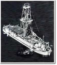 CUSS I
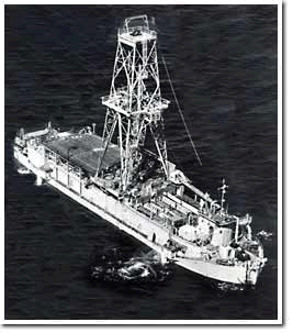

Project Mohole was an ambitious attempt to drill through the Earth's crust into the Mohorovičić discontinuity, and to provide an Earth science complement to the high profile Space Race. The project was initially led by the American Miscellaneous Society (AMSOC) with funding from the National Science Foundation.
Phase One was executed in spring 1961. Five holes were drilled off the coast of Guadalupe Island, Mexico, the deepest at 183 m (601 ft) below the sea floor in 3,500 m (11,700 ft) of water. This was unprecedented: not in the hole's depth but because of the depth of the ocean and because it was drilled from an untethered platform. Also, the core sample proved valuable, penetrating through Miocene age sediments for the first time to reveal the lowest 13 m (44 ft) consisting of basalt.
Project Mohole contracted with Global Marine of Los Angeles for the use of its oil drillship CUSS I. A consortium of Continental, Union, Superior and Shell Oil Companies, CUSS had originally developed it in 1956 as a technological test bed for the nascent offshore oil industry. CUSS I was one of the first vessels in the world capable of drilling in water depth up to 3,560 m (11,680 ft), while maintaining a position within a radius of 600 ft (180 m). Project Mohole expanded its operational range by inventing what is now known as dynamic positioning.
Phase One proved that both the technology and expertise were available to drill into the Earth's mantle. It was intended as the experimental phase of the project, and did succeed in drilling to a depth of 601 feet below the sea floor [1]. However, deeper drilling never took place: an attempted shift of operational control to NSF proved unsatisfactory, AMSOC dissolved itself, phase two of the project was abandoned and the entire project discontinued by Congress, objecting to increasing costs in 1966.[2]
Contents
See also
- Walter Munk
- Ocean Drilling Program
- Deep Sea Drilling Program
- Integrated Ocean Drilling Program
- Kola Superdeep Borehole
External links
- NSF Ocean Drilling Program
- Project Mohole photo gallery
- Geology History: Project Mohole
- NAS - Project Mohole
Bibliography
- A Hole in the Bottom of the Sea: The Story of the Mohole Project by Willard Bascom, 1961. ISBN 0385007116
- Oral History Interview. Willard Bascom, 1993.
- Oral History Interview. Robert Bauer, 1993
- Milton Lomask, "A Minor Miracle: An Informal History of the National Science Foundation." NSF
- Chandler, G. N. "Experimental Deep Water Drilling- Project Mohole" (Motion Picture, Library of Congress Catalogue Number: fi 68000006, 28 min)
References
- ^ http://www.nationalacademies.org/history/mohole/
- ^ Project Mohole, 1958-1966, National Academies, http://www.nationalacademies.org/history/mohole/, retrieved 2011-04-22
Categories:- Geophysics
- Marine geology
- Structure of the Earth
- Deepest boreholes
- Drillships
- History of earth science
Wikimedia Foundation. 2010.