- Map of Juan de la Cosa
-
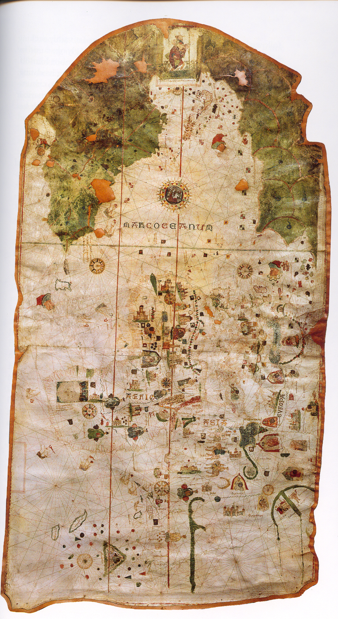
The map or chart of Juan de la Cosa is a mappa mundi painted on parchment, 93 cm high and 183 cm wide, currently preserved at the Museo Naval of Madrid (Spain). A line of text on the map says it was made by cartographer and sailor Juan de la Cosa in 1500 in the Andalusian port city of Puerto de Santa María. Its rich decoration hints that it was ordered by some powerful member of the court of the Catholic Monarchs,[1] who ruled the kingdoms of Castile and Aragon at that time.
This map is the earliest undisputed representation of the Americas. Some historians have claimed that some of the Antilles appear on earlier maps such as the Pizzigano map of 1424 but there is no consensus about it. Furthermore, the Vinland map shows part of North America but its dating is controversial. The La Cosa map shows the lands discovered up to the end of the 15th century by Castilian, Portuguese and English expeditions to America. It also depicts a large fraction of the Old World, according to the style of medieval portolan charts and including news of the arrival of Vasco de Gama to India in 1498.[1]
The map of Juan de la Cosa is the only cartographic work made by an eyewitness of the first voyages of Christopher Columbus to the Indies that has been preserved.[2] Possibly as an allusion to Columbus, it contains a large image of Saint Christopher that covers the region where Central America should have appeared. On the other hand, Cuba is drawn as an island, which contradicts Columbus' opinion that it was a peninsula of Asia.[3]
References
- ^ a b MARTÍN MERÁS, Luisa (2000). "La carta de Juan de la Cosa: interpretación e historia" (in Spanish). Monte Buciero (Ayuntamiento de Santoña) (4). ISSN 1138-9680, pp. 71-86. http://dialnet.unirioja.es/servlet/fichero_articulo?codigo=206305&orden=72914.
- ^ ALVAREZ, Aldo (2003). "Geomagnetism and the Cartography of Juan de la Cosa". http://www.sochistdisc.org/2003_articles/alvarez.htm. Retrieved November 4, 2008.
- ^ ELKHADEM, Hossam et al. (1992). "Juan de La Cosa, Parte correspondiente a la America de la Carta General de Juan de La Cosa..." (in French). Cartes de Amériques dans les collections de la Bibliothèque Royale Albert Ier. Bibliothèque Royale Albert Ier. http://www.kbr.be/america/fr/fr39.htm. Retrieved November 1, 2008.
See also
- Ancient world maps
- World map
External links
- Images
- High-resolution digital image, made by TALLERdigigráfico
- Texts
- J. Siebold, , Slide #305 Monograph
- Luis A. Robles Macias Juan de la Cosa’s Projection: A Fresh Analysis of the Earliest Preserved Map of the Americas, Coordinates, Series A nº. 9, 24 May 2010. Spanish version: La proyección de Juan de la Cosa.
Categories:- 1500 works
- Old maps of the world
Wikimedia Foundation. 2010.