- Archipelago Sea
Archipelago Sea (Finnish "Saaristomeri", Swedish "Skärgårdshavet") is a part of the
Baltic Sea between theGulf of Bothnia , theGulf of Finland and theSea of Åland , within Finnishterritorial waters . By some definitions it is the largest archipelago in the world by the number of islands, although the islands are very small and tightly clustered. Thepost-glacial rebound is relatively fast in the archipelago, causing noticeable changes within a lifetime.The larger islands are inhabited and connected by ferries and bridges. The
Åland Islands , including the largest islands of the region, form an autonomous region within Finland. The rest of the islands are part ofFinland Proper . The Archipelago Sea is a significant tourist destination.Geography and geology
The Archipelago Sea covers a roughly triangular area with the cities of
Mariehamn ,Uusikaupunki andHanko at the corners.The area can be divided into inner and outer archipelagos, with the outer archipelago consisting mainly of smaller, uninhabited islands.The archipelago has a very large number of
island s. The exact number depends on the definition of the term "island", as the size of the patches of dry land in the area varies from small rocks peeking out of the water to large islands with several villages or even a small town. The number of the larger islands of over 1 km2 within the Archipelago Sea is 257, whilst the number of smaller isles of over 0,5 ha is about 18000. If the number of smallest uninhabitable rocks and skerries is accounted, 50 000 is probably a good estimate.Fact|date=August 2008 In comparison, the number of islands inCanadian Arctic Archipelago is 36 563.Fact|date=August 2008 Indonesia has 17 508 islands, according to the Indonesian Naval Hydro-Oceanographic Office. [ [http://www.asianinfo.org/asianinfo/indonesia/pro-geography.htm] Geography of Indonesia at AsianInfo.org]The islands began emerging from the sea shortly after the last
ice age . Due to thepost-glacial rebound the process is still going on, with new skerries and islands being slowly created and old ones enlarged or merged. The current rate of rebound is between 4 and 10 millimetres a year. [ [http://www.ymparisto.fi/default.asp?contentid=68674&lan=fi] The website of Finland's environmental administration] Because the islands are made of mainlygranite andgneiss , two very hard types of rock,erosion is significantly slower than rebound. The sea area is shallow, with a mean depth of 23 m. Most of the channels are not navigable for large ships.There are three crater-like formations in the archipelago. One of them,
Lumparn inÅland , is a genuineimpact crater . [ [http://www.unb.ca/passc/ImpactDatabase/images/lumparn.htm] Lumparn in the Eart Impact Database] (coord|60|8|22|N|20|7|37|E) The two other formations areintrusion s. The more prominent of these is the Åva Intrusion in the municipality ofBrändö , which is easily notable in satellite photos and high-resolution maps. (coord|60|28|19|N|21|1|0|E) The other similar formation is in Fjälskär, between the main islands ofHoutskär andIniö . [ [http://arkisto.gtk.fi/kps/kps1041_1043.pdf] A study about the geology of the archipelago conducted by the Geological Survey of Finland] (coord|60|18|25|N|21|22|18|E)Demographics and administration
:"See also:
Åland Islands "
[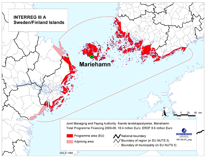
thumb|250px|right|Map_of_the_Sweden/Finland_Islands_Euroregion ] The islands are divided between the province ofWestern Finland and the autonomous province of Åland. The border between the provinces runs roughly alongSkiftet (Kihti in Finnish), a relatively open sea area. Together with the islands near the coast of Sweden the area forms aEuroregion . The main ports in the area areTurku on the continent, andMariehamn on the Åland islands.The Åland region is autonomous and demilitarized. It has its own regional parliament and has Swedish as its sole official language. The regional parliament has power over wide-ranging matters, including health services, education, environment, and postal services. Monetary and foreign policy are handled by the
Parliament of Finland . Thepresident of Finland has, in theory, right to veto the laws passed by the Åland regional parliament. [ [http://www.aland.ax/] The official pages of Åland]The number of permanent residents on the islands is roughly 60,000, with 27,000 of them living in Åland. Also outside Åland most of the area has been more or less monolingually Swedish-speaking, now officially bilingual with a Swedish-speaking majority. The northern part of the area is monolingually Finnish.
Many Finns have summer residences on the islands in the area, known for its natural beauty. Due to this the population of many islands can double or more during the summer. Although having a summer cottage in the archipelago is more common among the Swedish-speaking, the Swedish-speaking are a small minority on the mainland, and so most summer residents are Finnish-speaking, in contrast to the permanent residents.
Kultaranta , the official summer residence of thepresident of Finland is on the island ofLuonnonmaa inNaantali . [ [http://www.presidentti.fi/netcomm/news/ShowArticle.asp?intNWSAID=34096&LAN=EN] The summer residence of the president of Finland]An interesting feature in the
demographics in the archipelago is the number oftwins . The tendency for non-identical twin births is partlyhereditary , and the necessarygene s are prevalent in the archipelago. In the 18th and 19th centuries the proportion of twin births were greater than anywhere inEurope , and enormously higher than in continentalFinland . The reason for this wasfishing .Fish is an excellent source of protein andunsaturated fat . It was also available even when crops failed. Hence having twins maximizes lifetime reproductive success. [Lummaa, Virpi et al. (1998) "Natural selection on human twinning". Nature 394, 533-534 (6 August 1998)]The eastern part of the archipelago is defended by the
Archipelago Sea Naval Command , which has its main base inTurku . The defence is based largely onnaval mine s andcoastal artillery . [ [http://www.mil.fi/merivoimat/joukot/smmepa/] The Archipelao Sea Naval Command (in Finnish)] Both are effective in the archipelago, where the dense clusters of islands severely limit the manoeuvrability of invading vessels. The autonomous region of Åland is demilitarised. TheFinnish Defence Forces are not allowed to enter the area, and its residents are exempt from military service.Economy and communications
The islands generally enjoy a high
standard of living comparable to that of continentalFinland .Fishing andfish processing are major industries. The archipelago is well-known for its Balticherring andrainbow trout products.Agriculture is limited by the small size and rocky nature of the islands. However, theclimate is more favourable than in continentalFinland and some islands, particularlyRymättylä , are famous in the nearby continental areas for producing the first newpotato es of the summer. The significance oftourism to the economy of the islands is constantly increasing.The islands communities on the "Finnish" side of "Skiftet" are linked by the
Archipelago Ring Road , a chain of bridges and ferries. Islands lying farther away are linked by ferries, and in case of Åland, a smallairport . The ferries are divided into two categories. The "yellow" ferries ("landsvägsfärja" or simply "färja" in Swedish, "lossi" in Finnish) are free of charge and operate on short routes between adjacent (large) islands. They are raft-like in construction. The "white" ferries ("förbindelsebåt" in Swedish, "yhteysalus" in Finnish) are ship-like and charge a small fee. They operate on longer routes covering several smaller or more distant islands. Large cruiseferries connect the Finnish cities ofTurku andHelsinki to Åland andSweden .During cold winters official
ice road s are established between some islands. Driving on the ice is common also to islands lacking official ice roads. This greatly eases transportation, as it makes it possible to simply drive acar (or even a heavyvan if ice is very thick) from the continent to the islands. On the other hand, during spring and autumn there is a period of thaw ("menföre" in Swedish, "kelirikko" in Finnish) when the ice is too thin even for walking, but too thick for boating. This can leave some islands lacking a pier for large ships isolated for days or weeks.Many important
shipping lane s cross the Archipelago Sea. Navigation is made hazardous by the labyrinthine archipelago, varying depth and numerous skerries. For this reason the islands are dotted withlighthouse s of varying sizes and navigational marks.Maritime pilot services are maintained by the state.Culture
The culture of the archipelago resembles that of the Swedish-speaking coastal areas of Finland. Many features of typically Finnish culture, such as the popularity of
sauna , have became ingrained in the culture of the islands. There are, however, several subtle differences.Maypole s are an essential part of theMidsummer festival in the archipelago but not in the continent. On the other hand, the continental Finnish Midsummer tradition of lightingbonfire s has been introduced to the archipelago relatively recently.Based on the languages spoken the archipelago can be divided into three parts. The Åland archipelago in the west is completely Swedish-speaking, the
Åboland archipelago in the south is mostly Swedish-speaking and the northern archipelago is Finnish-speaking.Because christianity spread to the islands before the mainland, the churches on the major islands tend to be old, dating from the 13th, 14th and 15th centuries, with the oldest ones in
Åland . More than 80 % of Finns are members of theEvangelical Lutheran Church of Finland , and this proportion is even higher in the archipelago, as the area doesn't have an orthodox or catholic parish.The culinary culture of the archipelago resembles continental
Finnish cuisine . Naturally, there is a greater emphasis onfish , particularlybaltic herring ,salmon andrainbow trout . The island are also famous for traditional dark bread distinguished by the use ofbuttermilk ,syrup , andmalt among the ingredients. The main dish of theChristmas dinner is usually anorthern pike . Every Christmas the fishermen ofKorppoo deliver a pike for the president's table.Nature and conservation
The islands provide a unique and diverse environment for wildlife. The bigger islands resemble the coastal regions of continental
Finland whereas skerries have a radically different environment. Smaller islands are devoid oftree s, but still harbour richplant life. The environment is sunny, has a relatively longgrowing season and is fertilised byguano . On the other hand, nearly constantwind and thin or non-existentsoil limit plant growth. The very lowsalinity of theBaltic Sea makes splashes of seawater more benign for plantlife.The conditions can vary radically even within one small island, due to the features of the rock on which the islands are based. [ [http://www.luontoon.fi/page.asp?Section=404] Special characteristics of the archipelago nature at the website of the Archipelago Sea National Park (in Finnish)] There may be small patches of fresh-water
bog s,pond s of fresh water,pond s ofbrackish water , bushes,meadow s, barren rocks, wind-beaten shores and shelteredcove s on an island only a few tens of meters in diameter. Many plants have alteredphenotype s due to the environment. For example,juniper s on small islands grow only to a height less than 0,5 metres, but can cover several square metres.While most of the islands are rocky, some are actually extensions of the
Salpausselkä ridge system, and thus composed of terminal morraine. Such islands includeÖrö andJurmo . Theflora andfauna in these islands is more diverse than in their rocky neighbours.The islands are a haven for
seabird s. The species includemute swan ,black guillemot ,great crested grebe and numerous species ofsea gull s. Recentlygreat cormorant s have spread to the archipelago and their numbers are increasing. This not necessarily viewed as a good thing by nature lovers, sincegreat cormorant s live in dense colonies which will eventuallypoison surrounding plantlife by theirexcrement .The greatest threat to the environment is
eutrophication caused mainly byagriculture andfish farm s. [ [http://www.ymparisto.fi/default.asp?node=12491&lan=fi] Article about eutrofication in the website of Finland's environmental administration] This has been partly brought under control in Finland, but the effects are masked by the general decline in the condition of the Baltic Sea. Many areas of the archipelago are protected from human activity by their sheer inaccessibility. The are also many small nature conservation areas and theSouthwestern Archipelago National Park , where landing to some islands is restricted only to scientists. [ [http://www.luontoon.fi/page.asp?Section=403] Main page of the Archipelago Sea National Park]History
The islands began rising from the sea (at that stage called the
Yoldia Sea ) 10,000 years ago. The oldest archaeological finds inDragsfjärd date back to ca. 4000 BC and represent thePit-Comb Ware culture . During that period the outer archipelago was formed by the highest points of the main islands ofHoutskari ,Korppoo andNauvo . Due topost-glacial rebound the entire archipelago has risen approximately 25 meters since, enlarging existing islands and creating many more.During the 12th and 13th centuries
Sweden established its control of the Archipelago Sea. At the same time christianity started to spread to Finland, starting from the archipelago and the adjacent coastal area. The islands occupy a strategic position, guarding the approaches to Stockholm, Turku and the entire Gulf of Bothnia. Therefore they were fortified by theSwedish empire during the Middle Ages. A royal postal route used to go via the northern islands in the 16th and 17th century. In 1809 Sweden was forced to cede the islands toRussia , and they became part of theGrand Duchy of Finland .In 1808 the
War of Finland broke out betweenSweden andRussia . In April Russian troops occupied the archipelago, including Åland. Soon after the local residents, enraged by the confiscation of ships, rebelled. Aided by troops from Sweden the archipelago was cleared from Russian troops in May. The Swedish troops then used the islands as a staging area for the recapture of continental Finland. The archipelago remained in Swedish control until the end of the war, but in the subsequent Treaty of Fredrikshamn Sweden was forced to cede the area along with rest of Finland. The Archipelago Sea became part of the autonomousGrand Duchy of Finland under the Russian Empire.During the
Crimean war anAnglo-French force attacked and destroyed theBomarsund castle . In theÅland convention of 1856 the Åland side of the archipelago was demilitarised. The area remains so even today.Finland gained its independence from
Russia in 1917. Shortly after, the Swedish speaking inhabitants of theÅland Islands , in the western part of theArchipelago , appealed to Sweden to annex the islands. The request received mixed support in Sweden, but led to theÅland crisis . TheLeague of Nations was called in to resolve the situation, and in 1921 the League granted the sovereignty of the entire archipelago to Finland, despite the objections of the majority of Ålanders. However, Åland was given a wide autonomy, and its demilitarised status was reaffirmed.In 1939
Soviet Union invadedFinland in theWinter War . At the end of the war in 1940 Finland was forced to rentHanko at the eastern extreme of the Archipelago Sea toSoviet Union as a military base. In 1941 theWar of Continuation broke out. Finland sent troops toÅland to guard against a possible Soviet invasion, which didn't materialize. Finnish army also laid siege onHanko , which was evacuated by Soviet Union later that year. Finnish troops remained inÅland until the end of the war in 1944.In 1995 Finland became a member of the
European Union . Thereferendum on the membership was held separately inÅland , leading to the possibility of different outcomes. A rejection of the EU membership by the Ålanders would have created a situation similar to that ofGreenland , which belongs toDenmark but is not part of the EU. However, the membership was accepted in both referendums.Throughout its history the population of the Archipelago Sea has varied significanlty. The population increased until the first half of the 16th century. After that the population went into decline as the carrying capacity of the environment was reached and wars and pestilence took their toll on the people. In the 19th century the population increased sharply as new, more efficient fishing methods were introduced. In the 20th century the population went into decline again, especially on smaller islands, due to rapid
urbanization . Many smaller islands became completely uninhabited. During the recent decades increasing number of summer residences in the archipelago have revitalized some areas. [ [http://www.luontoon.fi/page.asp?Section=406] History of the archipelago at the website of the Archipelago Sea National Park (in Finnish)]List of municipalities
Island municipalities in
Finland Proper :Coastal municipalities in
Uusimaa which also include some islands:
*Hanko
*Ekenäs The archipelago continues further to the east in
Uusimaa , butHanko is traditionally seen as a dividing point between the Archipelago Sea and theGulf of Finland .Image gallery

Nagu church dating from the15th century 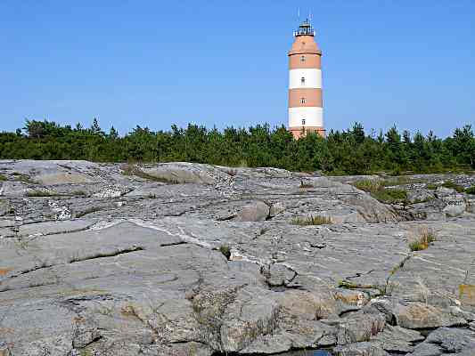
The_Isokari_lighthouse inKustavi 
Marina inKorpo 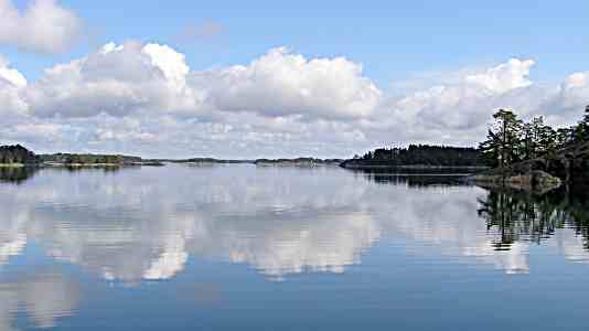
Hiittinen , 25 km west ofHanko ]
Jurmo 
Gullkrona 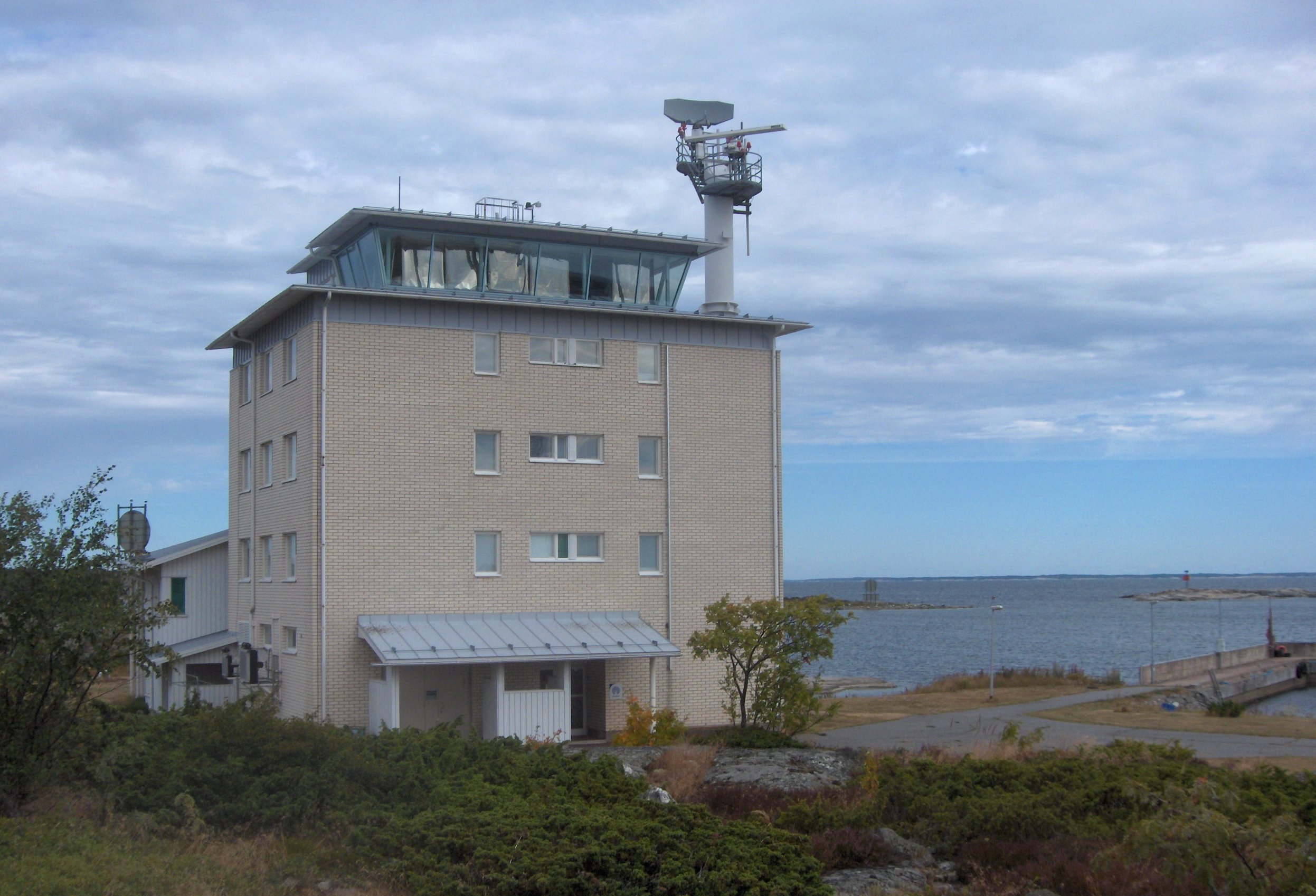
Isokari_maritime pilot station, responsible for guiding ships to the harbour ofUusikaupunki .External links
* [http://www.outdoors.fi/page.asp?Section=5300 Southwestern Archipelago National Park]
* [http://www.saaristo.org/ Turku Archipelago]
* [http://www.ukkopekka.fi Steamship s/s Ukkopekka cruise Naantali-Turku]
* [http://www.liikkujat.com/lautta/default.asp?kieli=EN Interactive map of the ferries in Finland]
* [http://www.venesatama.com All guest harbors in the Archipelago of Turku and Aland]References
Wikimedia Foundation. 2010.