- Chesapeake Bay
-
Chesapeake Bay Estuary  The Chesapeake Bay – Landsat photo
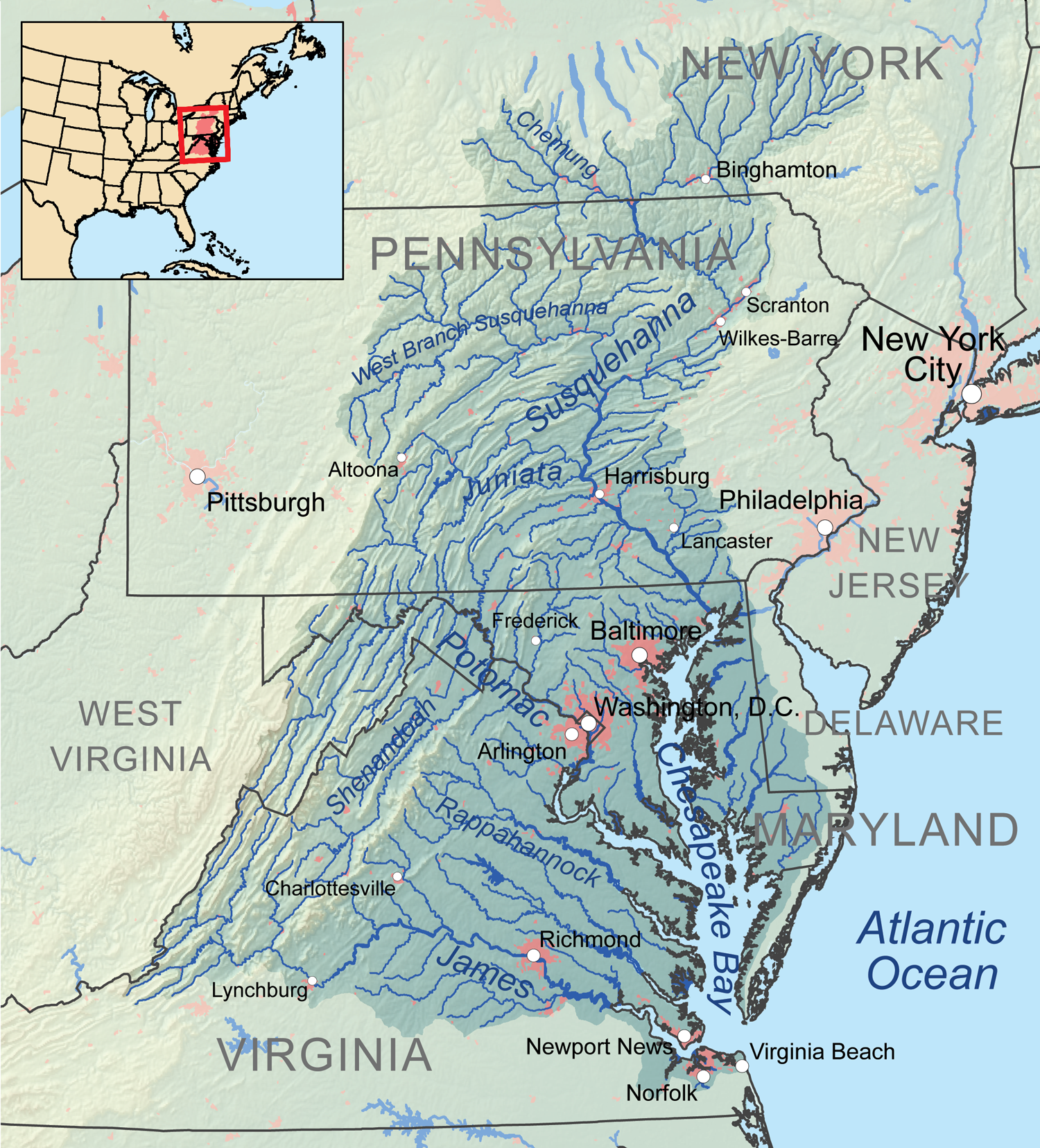
Name origin: Chesepiooc, Algonquian for village "at a big river" Country United States States Maryland, Virginia Tributaries - left Chester River, Choptank River, Nanticoke River, Pocomoke River - right Patapsco River, Patuxent River, Potomac River, Rappahannock River, York River, James River Source Susquehanna River - location Havre de Grace, MD - elevation 0 ft (0 m) - coordinates 39°32′35″N 76°04′32″W / 39.54306°N 76.07556°W Mouth Atlantic Ocean - location Virginia Beach, VA - elevation 0 ft (0 m) - coordinates 36°59′45″N 75°57′34″W / 36.99583°N 75.95944°W Length 200 mi (322 km) Width 30 mi (48 km) Depth 46 ft (14 m) Basin 64,299 sq mi (166,534 km2) Area 4,479 sq mi (11,601 km2) Discharge - average 78,300 cu ft/s (2,217 m3/s) [1] - max 389,000 cu ft/s (11,015 m3/s) - min 9,800 cu ft/s (278 m3/s)  Chesapeake Bay Watershed
The Chesapeake Bay (
 /ˈtʃɛsəpiːk/ chess-ə-peek) is the largest estuary in the United States.[2] It lies off the Atlantic Ocean, surrounded by Maryland and Virginia. The Chesapeake Bay's drainage basin covers 64,299 square miles (166,534 km2) in the District of Columbia and parts of six states: New York, Pennsylvania, Delaware, Maryland, Virginia, and West Virginia.[3] More than 150 rivers and streams drain into the bay.[2]
The Chesapeake Bay is approximately 200 miles (300 km) long, from the Susquehanna River in the north to the Atlantic Ocean in the south. At its narrowest point between Kent County's Plum Point (near Newtown) and the Harford County shore near Romney Creek, the bay is 2.8 miles (4.5 km) wide; at its widest point, just south of the mouth of the Potomac River, it is 30 miles (50 km) wide. Total shoreline for the bay and its tributaries is 11,684 miles (18,804 km), and the surface area of the bay and its major tributaries is 4,479 square miles (11,601 km2). Average depth of the bay is 46 feet (14 m) and the maximum depth is 208 feet (63 m).
The bay is spanned in two places. The Chesapeake Bay Bridge crosses the bay in Maryland from Sandy Point (near Annapolis) to Kent Island; and the Chesapeake Bay Bridge-Tunnel in Virginia connects Virginia Beach to Cape Charles. The bay has environmental issues but is noted for its beauty; in recent years, a pattern has been that it is becoming "emptier", with fewer crabs, oysters, and watermen.[4]
Contents
Etymology
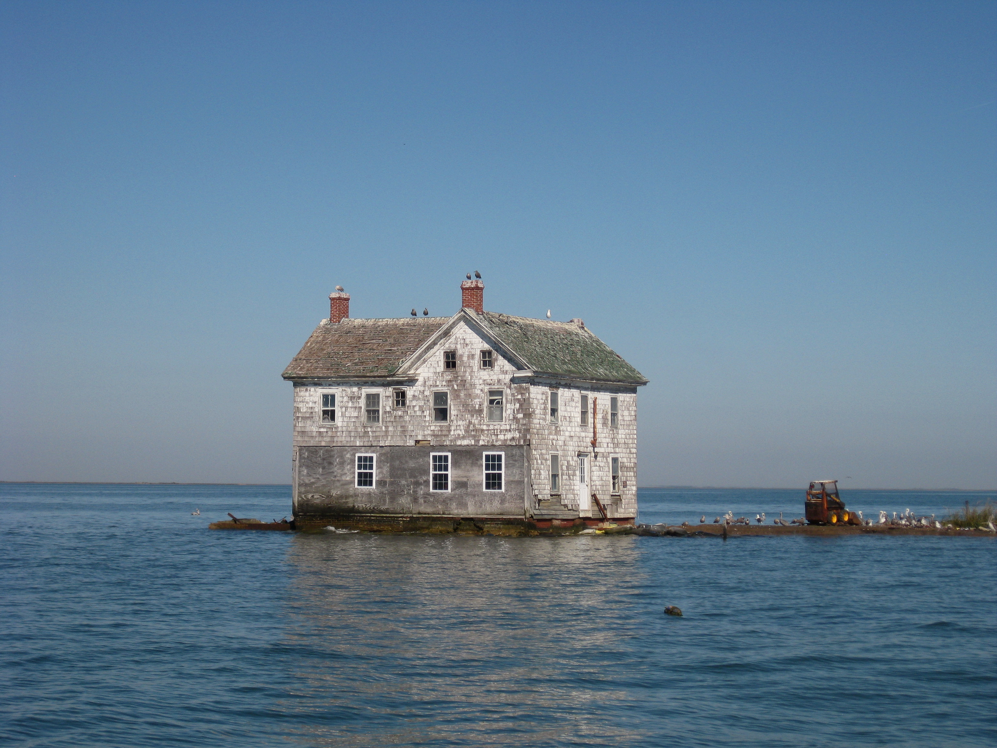
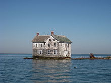 This abandoned house fell into the Chesapeake Bay in 2010
The word Chesepiooc is an Algonquian word referring to a village "at a big river." It is the seventh oldest surviving English place-name in the U.S., first applied as "Chesepiook" by explorers heading north from the Roanoke Colony into a Chesapeake tributary in 1585 or 1586.[5] In 2005, Algonquian linguist Blair Rudes "helped to dispel one of the area's most widely held beliefs: that 'Chesapeake' means something like 'Great Shellfish Bay.' It does not, Rudes said. The name might actually mean something like 'Great Water,' or it might have been just a village at the bay's mouth."[6]
Geology
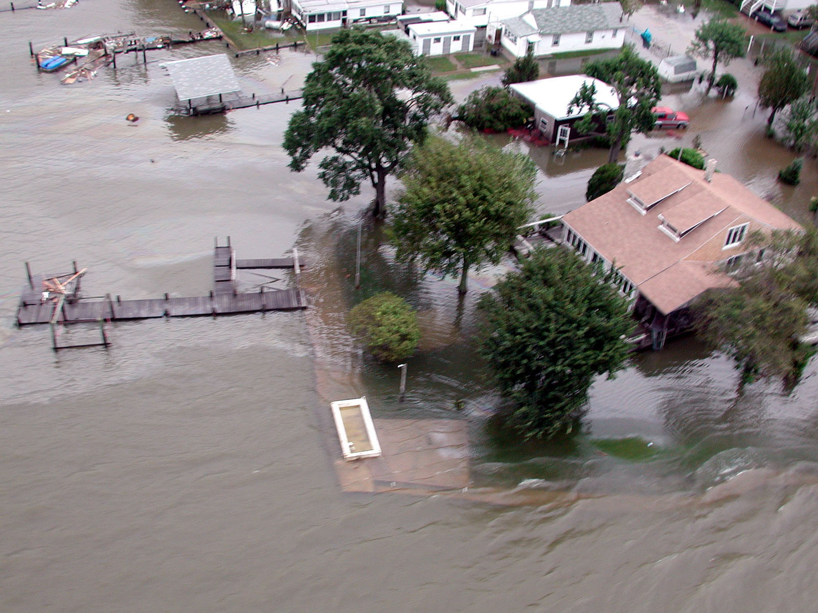
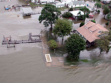 Floodwaters from Hurricane Isabel (2003) wash over Miller's Island in the Chesapeake Bay
The Chesapeake Bay is the ria, or drowned valley, of the Susquehanna, meaning that it was where the river flowed when the sea level was lower. It is not a fjord, as the Laurentide Ice Sheet never reached as far south as the northernmost point on the bay.
The bay's geology, its present form, and its very location were created by a bolide impact event at the end of the Eocene (about 35.5 million years ago), forming the Chesapeake Bay impact crater and the Susquehanna River valley much later. The bay was formed starting about 10,000 years ago when rising sea levels at the end of the last ice age flooded the Susquehanna River valley.[3] Parts of the bay, especially the Calvert County, Maryland, coastline, are lined by cliffs composed of deposits from receding waters millions of years ago. These cliffs, generally known as Calvert Cliffs, are famous for their fossils, especially fossilized shark teeth which are commonly found washed up on the beaches next to the cliffs. Scientists' Cliffs is a beach community in Calvert County named for the desire to create a retreat for scientists when the community was founded in 1935.[7]
Much of the bay is quite shallow. At the point where the Susquehanna River flows into the bay, the average depth is 30 feet (9 m), although this soon diminishes to an average of 10 feet (3 m) from the city of Havre de Grace for about 35 miles (56 km), to just north of Annapolis. On average, the depth of the bay is 21 feet (7 m), including tributaries;[8] over 24% of the bay is less than 6 ft (2 m) deep.[9]
The climate of the area surrounding the bay is primarily humid subtropical, with hot, very humid summers and cold to mild winters. Only the area around the mouth of the Susquehanna River is continental in nature, and the mouth of the Susquehanna River and the Susquehanna flats often freeze in winter. It is rare for the surface of the bay to freeze in winter, which happened most recently in the winter of 1976–77.[10]
Since the bay is an estuary, it has fresh water, salt water and brackish water. Brackish water has three salinity zones — oligohaline, mesohaline, and polyhaline. The fresh water zone runs from the mouth of the Susquehanna River to north Baltimore. The oligohaline zone has very little salt. Salinity varies from 0.5 ppt to 10 ppt, and freshwater species can survive there. The north end of the oligohaline zone is north Baltimore and the south end is the Chesapeake Bay Bridge. The mesohaline zone has a medium amount of salt and runs from the Bay Bridge to the mouth of the Rappahannock River. Salinity there ranges from 10.7 ppt to 18 ppt. The polyhaline zone is the saltiest zone, and some of the water can be as salty as sea water. It runs from the mouth of the Rappahannock River to the mouth of the bay. The salinity ranges from 18.7 ppt to 36 ppt. (36 ppt is as salty as the ocean.)
History
Spanish explorer Lucas Vásquez de Ayllón sent an expedition out from Hispaniola in 1525 which reached the mouths of the Chesapeake and Delaware Bays. It may have been the first European expedition to explore parts of the Chesapeake Bay, which the Spaniards called "Bahía de Santa María."[11] De Ayllón established a short-lived Spanish mission settlement, San Miguel de Gualdape, in 1526 along the Atlantic coast. Many scholars doubt the assertion that it was as far north as the Chesapeake; most place it in present-day Georgia's Sapelo Island.[12]
Captain John Smith of England explored and mapped the bay between 1607 and 1609. Smith wrote in his journal:
Heaven and earth have never agreed better to frame a place for man's habitation.[13]There was a mass migration of southern English cavaliers and their Irish and Scottish servants to the Chesapeake Bay region between 1640 and 1675. The "Captain John Smith Chesapeake National Historic Trail", the United States' first all-water National Historic Trail, was created in July 2006.[14]
 Oyster boats at war off the Maryland shore (1886 wood engraving)
The Chesapeake Bay was the site of the Battle of the Chesapeake in 1781, during which the French fleet defeated the Royal Navy in the decisive naval battle of the American Revolutionary War. In the War of 1812, British warships attacked Fort McHenry at one point; in a separate attack, British troops sailed up the Chesapeake, landed on the west side near Washington D.C., and trekked overland to burn the capital. There were so-called Oyster Wars in the late nineteenth and early twentieth centuries.
During the Great Depression in the 1930s, catching and eating oysters continued to be popular.[15]
Today, the Calvert Cliffs Nuclear Power Plant uses water from the bay to cool its reactor.
The bay is known for the Chesapeake Bay Retriever, a dog breed developed in this area. The Chesapeake Bay Bridge-Tunnel was built, connecting Virginia's eastern shore with its mainland and is approximately 20 miles (32 km) long; it has trestle bridges as well as two stretches of two-mile (3 km)-long tunnels which allow unimpeded shipping; the bridge is supported by four 5.25-acre (21,200 m2) man-made islands.[16]
Watershed
The largest rivers flowing directly into the bay, from north to south, are:
- Susquehanna River
- Patapsco River
- Chester River
- Choptank River
- Patuxent River
- Nanticoke River
- Potomac River
- Pocomoke River
- Rappahannock River
- York River
- James River
Flora and fauna
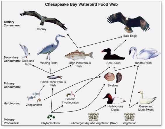
 Food chain diagram for waterbirds of the Chesapeake Bay
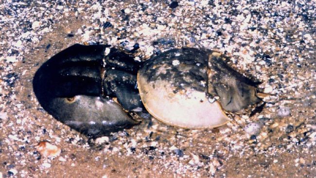
 Horseshoe crabs mate in May.
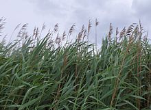 Reeds along the bay
The Chesapeake Bay is home to numerous fauna that either migrate to the bay at some point during the year or live there year round. There are over 300 species of fish and numerous shellfish and crab species. Some of these include the Atlantic menhaden, Striped bass, American eel, Eastern oyster, and the Blue crab.
Bird predators include the American Osprey, Great Blue Heron, the Bald Eagle,[17] Peregrine Falcon, the last two of which were threatened by DDT; their numbers plummeted but have risen in recent years.[18]
The Piping Plover is a near threatened species which inhabits the wetlands.[18]
Numerous flora also make the Chesapeake Bay their home both on land and underwater. Common submerged aquatic vegetation includes eelgrass and widgeon grass. A report in 2011 suggested that information on underwater grasses would be released, since "submerged grasses provide food and habitat for a number of species, adding oxygen to the water and improving water clarity."[19] Other vegetation that makes its home in other parts of the bay are wild rice, various trees like the red maple and bald cypress, and spartina grass and phragmites.[20]
Fishing industry
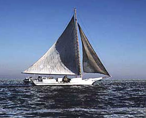
The bay is mostly known for its seafood production, especially blue crabs,[21] clams and oysters. The plentiful oyster harvests led to the development of the skipjack, the state boat of Maryland, which is the only remaining working boat type in the United States still under sail power. Other characteristic bay-area workboats include the log canoe, the pungy, the bugeye, and the Chesapeake Bay deadrise.[22]
In the middle of the twentieth century, the bay supported 9,000 full-time watermen, according to one account.[21] Today, the body of water is less productive than it used to be because of runoff from urban areas (mostly on the Western Shore) and farms (especially on the Eastern Shore and in the Susquehanna River watershed), over-harvesting, and invasion of foreign species.
The bay is famous for its rockfish, a regional name for striped bass. Once on the verge of extinction, rockfish have made a significant comeback because of legislative action that put a moratorium on rockfishing, which allowed the species to re-populate. Rockfish are now able to be fished in strictly controlled and limited quantities.
Oyster farming is a growing industry for the bay to help maintain the estuary's productivity as well as a natural effort for filtering impurities from the water in an effort to reduce the effects of man-made pollution. Oysters are hermaphroditic and will change gender at least once during their lifetime, often starting as male and ending as female; there are numerous ways to cook and eat them, as well as recipes and sauces to accompany oyster dishes.[15] One account:
The Chesapeake oyster – sometimes called Chesapeake white gold – has a flavor and texture that begs connoisseurs to come back and shuck just a few more.Environmental
 Tidal wetlands of the Chesapeake Bay
In the 1970s, the Chesapeake Bay was discovered to contain one of the planet's first identified marine dead zones, where hypoxic waters were so depleted of oxygen they were unable to support life, resulting in massive fish kills. Today the bay's dead zones are estimated to kill 75,000 tons of bottom-dwelling clams and worms each year, weakening the base of the estuary's food chain and robbing the blue crab in particular of a primary food source. Crabs are sometimes observed to amass on shore to escape pockets of oxygen-poor water, a behavior known as a "crab jubilee". Hypoxia results in part from large algal blooms, which are nourished by the runoff of residential, farm and industrial waste throughout the watershed. One report in 2010 criticized Amish farmers for having cows which "generate heaps of manure that easily washes into streams and flows onward into the Chesapeake Bay."[23]
The runoff and pollution have many components that help contribute to the algal blooms which is mainly fed by phosphorus and nitrogen.[24] This algae prevents sunlight from reaching the bottom of the bay while alive and deoxygenates the bay's water when it dies and rots. The erosion and runoff of sediment into the bay, exacerbated by devegetation, construction and the prevalence of pavement in urban and suburban areas, also blocks vital sunlight. The resulting loss of aquatic vegetation has depleted the habitat for much of the bay's animal life. Beds of eelgrass, the dominant variety in the southern bay, have shrunk by more than half there since the early 1970s. Overharvesting, pollution, sedimentation and disease has turned much of the bay's bottom into a muddy wasteland.[25]
One particularly harmful source of toxicity is Pfiesteria piscicida, which can affect both fish and humans. Pfiesteria caused a small regional panic in the late 1990s when a series of large blooms started killing large numbers of fish while giving swimmers mysterious rashes, and nutrient runoff from chicken farms was blamed for the growth.[26]
The bay improved slightly in terms of the overall health of its ecosystem, earning a rating of 31 out of 100 in 2010, up from 28 in 2008.[2] An estimate in 2006 from a "blue ribbon panel" said cleanup costs would be $15 billion.[13] Compounding the problem is the fact that 100,000 new residents move to the area each year.[13] A report in 2008 in the Washington Post suggested that government administrators had overstated progress on cleanup efforts as a way to "preserve the flow of federal and state money to the project."[27] In 2011 in January, there were reports that millions of fish had died, but officials suggested it was probably the result of extremely cold weather.[28]
Depletion of oysters
While the bay's salinity is ideal for oysters and the oyster fishery was at one time the bay's most commercially viable,[29] the population has in the last fifty years been devastated. Maryland once had roughly 200,000 acres (810 km2) of oyster reefs. Today it has about 36,000.[29] It has been estimated that in pre-colonial times, oysters could filter the entirety of the bay in about 3.3 days; by 1988 this time had increased to 325 days.[30] The harvest's gross value decreased 88% from 1982 to 2007.[31] One report suggested the bay had fewer oysters in 2008 than 25 years earlier.[4]
The primary problem is overharvesting. Lax government regulations allow anyone with a license to remove oysters from state-owned beds, and although limits are set, they are not strongly enforced.[29] The overharvesting of oysters has made it difficult for them to reproduce, which requires close proximity to one another. A second cause for the oyster depletion is that the drastic increase in human population caused a sharp increase in pollution flowing into the bay.[29]
The bay's oyster industry has also suffered from two diseases: MSX and Dermo.[32]
Oyster recovery attempts
The depletion of oysters has had a particularly harmful effect on the quality of the bay. Oysters serve as natural water filters, and their decline has further reduced the water quality of the bay. Water that was once clear for meters is now so turbid that a wader may lose sight of their feet before their knees are wet.
Efforts of federal, state and local governments, working in partnership through the Chesapeake Bay Program, and the Chesapeake Bay Foundation and other nonprofit environmental groups, to restore or at least maintain the current water quality have had mixed results. One particular obstacle to cleaning up the bay is that much of the polluting substances arise far upstream in tributaries lying within states far removed from the bay. Despite the state of Maryland spending over $100 million to restore the bay, conditions have continued to grow worse. Twenty years ago, the bay supported over six thousand oystermen. There are now fewer than 500.[33]
Efforts to repopulate the bay via hatcheries have been carried out by a group called the Oyster Recovery Partnership, with some success. They recently placed 6 million oysters on 8 acres (32,000 m2) of the Trent Hall sanctuary.[34] Scientists from the Virginia Institute of Marine Science at the College of William & Mary claim that experimental reefs created in 2004 now house 180 million native oysters, Crassostrea virginica, which is far less than the billions that once existed.[35]
Tourism
The Chesapeake Bay is a main feature for tourists who visit Maryland and Virginia each year. Fishing, crabbing, swimming, boating, kayaking,[17] and sailing are extremely popular activities enjoyed on the waters of the Chesapeake Bay. As a result, tourism has a notable impact on Maryland's economy[36] One report suggested that Annapolis was an appealing spot for families, water sports and boating.[37] Commentator Terry Smith spoke about the bay's beauty:
The water is glassy, smooth and gorgeous, his wake white against the deep blue. That's the problem with the Chesapeake. It's so damned beautiful.[13]One account suggested how the Chesapeake attracts people:
You see them everywhere on Maryland's Eastern Shore, the weekend sailors. They are unmistakable with their deep tans, their baggy shorts, their frayed polo shirts, their Top-Siders worn without socks. Some may not even own their own boats, much less win regattas, but they are inexorably drawn to the Chesapeake Bay ... I planned to spend my days boating, eating as many Chesapeake Bay blue crabs as possible and making a little study of Eastern Shore locals. For city folk like me, they're interesting, even exotic –the weather-beaten crabbers and oystermen called "watermen," gentlemen-farmers and sharecroppers, boat builders, antiques dealers – all of whom sound like Southerners with mouthfuls of marbles when they talk. — Susan Spano, LA Times, 2008[38]Tom Wisner has recorded several albums, often about the Chesapeake Bay, and he tried to "capture the voice of the water and the sky, of the rocks and the trees, of the fish and the birds, of the gods of nature he believed still watched over it all."[39] He was known as the Bard of the Chesapeake Bay.[39]
Publications
There are several magazines and publications that cover topics directly related to the Chesapeake Bay and life and tourism within the bay region.
The Capital Newspaper, based in Annapolis, reports about news pertaining to the Western Shore of Maryland and the Annapolis area.[40] Chesapeake Bay Magazine and PropTalk focus on powerboating while SpinSheet focuses on sailing.[41][42][43]
Fiction
- Chesapeake, a 1978 novel by author James A. Michener
- John Barth's 1982 Sabbatical: A Romance, a novel centered on a yacht race through the Chesapeake Bay
- John Barth's 1987 The Tidewater Tales, a novel in which a married couple tell stories to each other as they cruise the bay.
- Jacob Have I Loved by Katherine Paterson, winner of the 1981 Newbery Medal. This is a novel about the relationship between two sisters in a waterman family who grow up on an island in the Bay.
See also
- Chesepian
- Delmarva Peninsula
- Dead zone (ecology)
- Chessie (sea monster)
- National Estuarine Research Reserve System
- List of islands in Maryland (with the islands in the bay)
- Coastal and Estuarine Research Federation
- Chesapeake Climate Action Network
- Chesapeake Bay Interpretive Buoy System
- Chesapeake and Delaware Canal
References
- ^ "Estimated Streamflow Entering Chesapeake Bay". ME-DE-DC Water Science Center. U.S. Geological Survey. 2011-05-05. http://md.water.usgs.gov/waterdata/chesinflow/. Retrieved 2011-05-06.
- ^ a b c LESLIE KAUFMAN (December 28, 2010). "More Blue Crabs, but Chesapeake Bay Is Still at Risk, Report Says". The New York Times. http://green.blogs.nytimes.com/2010/12/28/more-blue-crabs-but-chesapeake-bay-still-is-at-risk-report-says/. Retrieved 2011-04-20.
- ^ a b "Fact Sheet 102-98 - The Chesapeake Bay: Geologic Product of Rising Sea Level". U. S. Geological Survey. 1998-11-18. http://pubs.usgs.gov/fs/fs102-98/. Retrieved 2008-01-13.
- ^ a b David A. Fahrenthold (December 28, 2008). "Way of Life Slipping Away Along Chesapeake's Edge". Washington Post. http://www.washingtonpost.com/wp-dyn/content/article/2008/12/27/AR2008122701126.html. Retrieved 2011-04-20.
- ^ Also shown as "Chisupioc" (by John Smith) and "Chisapeack", in Algonquian "Che" means "big" or "great", "sepi" means river, and the "oc" or "ok" ending indicated something (a village, in this case) "at" that feature. "Sepi" is also found in another placename of Algonquian origin, Mississippi. The name was soon transferred by the English from the big river at that site to the big bay. Stewart, George (1945). Names on the Land: A Historical Account of Place-Naming in the United States. New York: Random House. p. 23.
- ^ Farenthold, David A. (2006-12-12). "A Dead Indian Language Is Brought Back to Life". The Washington Post: p. A1. http://www.washingtonpost.com/wp-dyn/content/article/2006/12/11/AR2006121101474_2.html?nav=rss_email/components. Retrieved 2007-03-19.
- ^ "FAQ". Scientists Cliffs community. http://www.scientistscliffs.org/HTML/FAQs/FAQs.htm. Retrieved 2008-05-08.[dead link]
- ^ "Geography". Chesapeake Bay Foundation. http://www.cbf.org/site/PageServer?pagename=exp_sub_watershed_geography. Retrieved 2008-04-21.[dead link] Other sources give values of 25 feet (e.g. "Charting the Chesapeake 1590-1990". Maryland State Archives. http://www.msa.md.gov/msa/speccol/sc2200/sc2269/html/chartfront.html. Retrieved 2008-04-21.) or 30 feet deep ("Healthy Chesapeake Waterways" (PDF). University of Maryland Center for Environmental Science. Archived from the original on 2008-06-26. http://web.archive.org/web/20080626004705/http://ian.umces.edu/pdfs/iannewsletter1.pdf. Retrieved 2008-04-21.)
- ^ "Chesapeake Bay Program: A Watershed Partnership: Facts & Figures". chesapeakebay.net (Chesapeake Bay Program Office). 2010-05-04. http://www.chesapeakebay.net/factsandfigures.aspx?menuitem=14582. Retrieved 2010-10-29.
- ^ "The Big Freeze". Time. 1977-01-31. http://www.time.com/time/magazine/article/0,9171,918620-2,00.html. Retrieved 2007-03-19
- ^ Grymes, Charles A. "Spanish in the Chesapeake". http://www.virginiaplaces.org/settleland/spanish.html. Retrieved 2010-07-08.
- ^ Weber, David (1994). The Spanish Frontier in North America. New Haven, CT: Yale University Press. pp. 36, 37.
- ^ a b c d Terry Smith (commentator), Michele Norris (host) (April 13, 2006). "The Chesapeake Bay, Scenic and Unhealthy". NPR. http://www.npr.org/templates/story/story.php?storyId=5341055. Retrieved 2011-04-20.
- ^ "H.R. 5466 [109th] Captain John Smith Chesapeake National Historic Trail Designation Act". GovTrack.us. http://www.govtrack.us/congress/bill.xpd?bill=h109-5466. Retrieved December 16, 2007.
- ^ a b Morris, Kendra Bailey (November 21, 2007). "Consider the Chesapeake Bay Oyster". NPR. http://www.npr.org/templates/story/story.php?storyId=16369187. Retrieved April 20, 2011.
- ^ Wollf, J.D. (April 20, 2011). "Fishing at the Chesapeake Bay Bridge Tunnel". USA Today. http://traveltips.usatoday.com/fishing-chesapeake-bay-bridge-tunnel-33269.html. Retrieved April 20, 2011.
- ^ a b Elton Dunn, Demand Media (2011-04-20). "Chesapeake Bay Kayak Tours". USA Today. http://traveltips.usatoday.com/chesapeake-bay-kayak-tours-2207.html. Retrieved 2011-04-20.
- ^ a b Blankenship, Karl (September 1995). Endangered Species Around the Chesapeake. 5. http://www.bayjournal.com/article.cfm?article=916.
- ^ Associated Press (April 20, 2011). "Chesapeake Bay Program to release new data on underwater grasses in bay, rivers". Washington Post. http://www.washingtonpost.com/national/chesapeake-bay-program-to-release-new-data-on-underwater-grasses-in-bay-rivers/2011/04/20/AFDaghAE_story.html. Retrieved 2011-04-20.
- ^ Domes S., Lewis M., Moran R., Nyman D.. “Chesapeake Bay Wetlands”. Emporia State University. May 2009. Retrieved 2010-03-14.
- ^ a b Grimes, William (April 30, 2008). "William W. Warner, Chesapeake Bay Author, Dies at 88". New York Times. http://www.nytimes.com/2008/04/30/books/30warner.html. Retrieved April 20, 2011.
- ^ "Chesapeake Bay Workboats". Chesapeake Bay Gateway Network. http://www.baygateways.net/workboats.cfm. Retrieved 2007-03-19.
- ^ SINDYA N. BHANOO (June 8, 2010). "Amish Farming Draws Rare Government Scrutiny". The New York Times. http://www.nytimes.com/2010/06/09/science/earth/09amish.html. Retrieved 2011-04-20.
- ^ Dennen, R. (2009-10-30). "Is it time we put the ailing Bay on diet?". The Free Lance Star. Retrieved 2010-02-17
- ^ "Bad Water and the Decline of Blue Crabs in the Chesapeake Bay". Chesapeake Bay Foundation. 2008-12. http://www.cbf.org/Document.Doc?id=172. Retrieved 2009-01-21.
- ^ Fahrenthold, David A. (2008-09-12). "Md. Gets Tough on Chicken Farmers". Washington Post. http://www.washingtonpost.com/wp-dyn/content/article/2008/09/11/AR2008091103841.html.
- ^ David A. Fahrenthold (December 27, 2008). "Failing the Chesapeake Bay -- Broken Promises on the Bay". Washington Post. http://www.washingtonpost.com/wp-dyn/content/article/2008/12/26/AR2008122601712.html. Retrieved 2011-04-20.
- ^ "Two Million Dead Fish Appear in Chesapeake Bay". CBS News. Jan. 5, 2011. http://www.cbsnews.com/stories/2011/01/05/national/main7216597.shtml. Retrieved 2011-04-20.
- ^ a b c d Oysters: Gem of the Ocean, The Economist, December 8, 2008; accessed September 2, 2009.
- ^ "Oyster Reefs: Ecological importance". US National Oceanic and Atmospheric Administration. http://habitat.noaa.gov/restorationtechniques/public/habitat.cfm?HabitatID=2&HabitatTopicID=11. Retrieved 2007-11-06.
- ^ "Estimating Net Present Value in the Northern Chesapeake Bay Oyster Fishery". NOAA Chesapeake Bay Office. 2008-11-07. http://www.nao.usace.army.mil/OysterEIS/PeerReviews/ResearchDocs/OysterNPV1107_rev_1.pdf. Retrieved 2009-09-08.
- ^ "Research – Shellfish Diseases". Virginia Institute of Marine Science. 2007-03-16. http://www.vims.edu/env/research/shellfish/. Retrieved 2008-02-22.[dead link]
- ^ Urbina, Ian (November 29, 2008). In Maryland, Focus on Poultry Industry Pollution. The New York Times. p. A14. http://www.nytimes.com/2008/11/29/us/29poultry.html?partner=rss&emc=rss
- ^ Program turns pork into oysters, Jesse Yeatman, South Maryland Newspapers Online, August 12, 2009.
- ^ Oysters Are on the Rebound in the Chesapeake Bay, Henry Fountain, The New York Times, August 3, 2009; accessed September 8, 2009.
- ^ http://executiveorder.chesapeakebay.net/post/Targeting-Resources-to-Better-Protect-the-Chesapeake-Bay-is-Aim-of-US-Department-of-Agriculture.aspx
- ^ ANNE GLUSKER (October 9, 2005). "A Treasure Chest of Fun on Chesapeake Bay". The New York Times. http://travel.nytimes.com/2005/10/09/travel/09kids.html. Retrieved 2011-04-20.
- ^ SUSAN SPANO (June 23, 2002). "Peak Season on Chesapeake Bay". Los Angeles Times. http://www.latimes.com/travel/la-062302maryland,0,2017585.story. Retrieved 2011-04-20.
- ^ a b Jenna Johnson (April 9, 2010). "Tom Wisner; Chesapeake Bay served as bard’s muse; at 79". Boston Globe. http://www.boston.com/bostonglobe/obituaries/articles/2010/04/09/tom_wisner_chesapeake_bay_served_as_bards_muse_at_79/. Retrieved 2011-04-20.
- ^ "Top Stories". The Capital Newspaper (Capital Gazette Communications). http://www.hometownannapolis.com/cgi-bin/read/TOP.html. Retrieved April 22, 2011.
- ^ Chesapeake Bay Magazine. http://www.chesapeakeboating.net. Retrieved April 22, 2011.
- ^ PropTalk (PropTalk Media LLC). http://www.proptalk.com. Retrieved April 22, 2011.
- ^ SpinSheet (SpinSheet Publishing Co.). http://www.spinsheet.com/. Retrieved April 22, 2011.
Further reading
- Cleaves, E.T. et al. (2006). Quaternary geologic map of the Chesapeake Bay 4º x 6º quadrangle, United States [Miscellaneous Investigations Series; Map I-1420 (NJ-18)]. Reston, VA: U.S. Department of the Interior, U.S. Geological Survey.
- Phillips, S.W., ed. (2007). Synthesis of U.S. Geological Survey science for the Chesapeake Bay ecosystem and implications for environmental management [U.S. Geological Survey Circular 1316]. Reston, VA: U.S. Department of the Interior, U.S. Geological Survey.
- Thomas, William G., III. "The Chesapeake Bay." Southern Spaces, April 16, 2004, http://southernspaces.org/2004/chesapeake-bay.
- William W. Warner, Beautiful Swimmers, about the history, ecology and anthropology of the Chesapeake Bay, published 1976
External links
- Eyes on the Bay Maryland Department of Natural Resources' Chesapeake and Coastal Bays Water Quality Data and Information
- Bay Backpack – Chesapeake Bay education resources for educators
- Chesapeake Bay Foundation
- Chesapeake Research Consortium
- Alliance for the Chesapeake Bay
- Chesapeake Bay Program
- Chesapeake Bay Journal
- Chesapeake Bay Gateways Network
- Chesapeake Community Modeling Program
- Chesapeake Bay Bridge (near Annapolis, MD)
- Chesapeake Bay Bridge-Tunnel
- Maryland Sea Grant
- National Geographic- Saving The Chesapeake
- National Geographic- Exploring The Chesapeake Then and Now
- National Geographic Magazine Jamestown/Werowocomoco Interactive
- Captain John Smith Chesapeake National Historic Water Trail.
- University of Maryland Center for Environmental Science Research and science application activities emphasizing Chesapeake Bay and its watershed.
- Chesapeake Bay Health Report Card
- Always-Updated Event Calendar for the Chesapeake Bay.
 Commonwealth of Virginia
Richmond (capital) Topics Climate · Colleges and universities · Colony · Congressional Districts · Culture · Delegations · Demographics · Economy · Education · Environment · Furniture · Geography · Government · Governors · History · Historic Landmarks · Magisterial Districts · Homes · Music · People · Police · Politics · Rights · Rivers · School divisions · Scouting · Slogan · Sports teams · State Fair · State parks · Symbols · Towns · Transportation · Tribes · Visitor Attractions
Regions Allegheny Mountains · Atlantic Coastal Plain · Blue Ridge · Chesapeake Bay · Cumberland Mountains · Delmarva Peninsula · Eastern Shore · Hampton Roads · Middle Peninsula · Northern Neck · Northern Virginia · Piedmont · Ridge-and-Valley Appalachians · Shenandoah Valley · South Hampton Roads · Southside · Southwest Virginia · Tennessee Valley · Tidewater · Tri-Cities · Virginia Peninsula
Metro areas Blacksburg-Christiansburg-Radford · Bluefield · Bristol · Charlottesville · Culpeper · Danville · Fredericksburg · Harrisonburg · Lynchburg · Martinsville · Richmond · Roanoke · Staunton · Hampton Roads · Washington-Arlington-Alexandria · Waynesboro · Winchester
Counties Accomack · Albemarle · Alleghany · Amelia · Amherst · Appomattox · Arlington · Augusta · Bath · Bedford · Bland · Botetourt · Brunswick · Buchanan · Buckingham · Campbell · Caroline · Carroll · Charles City · Charlotte · Chesterfield · Clarke · Craig · Culpeper · Cumberland · Dickenson · Dinwiddie · Essex · Fairfax · Fauquier · Floyd · Fluvanna · Franklin · Frederick · Giles · Gloucester · Goochland · Grayson · Greene · Greensville · Halifax · Hanover · Henrico · Henry · Highland · Isle of Wight · James City · King and Queen · King George · King William · Lancaster · Lee · Loudoun · Louisa · Lunenburg · Madison · Mathews · Mecklenburg · Middlesex · Montgomery · Nelson · New Kent · Northampton · Northumberland · Nottoway · Orange · Page · Patrick · Pittsylvania · Powhatan · Prince Edward · Prince George · Prince William · Pulaski · Rappahannock · Richmond · Roanoke · Rockbridge · Rockingham · Russell · Scott · Shenandoah · Smyth · Southampton · Spotsylvania · Stafford · Surry · Sussex · Tazewell · Warren · Washington · Westmoreland · Wise · Wythe · York
Independent
citiesAlexandria · Bedford · Bristol · Buena Vista · Charlottesville · Chesapeake · Colonial Heights · Covington · Danville · Emporia · Fairfax · Falls Church · Franklin · Fredericksburg · Galax · Hampton · Harrisonburg · Hopewell · Lexington · Lynchburg · Manassas · Manassas Park · Martinsville · Newport News · Norfolk · Norton · Petersburg · Poquoson · Portsmouth · Radford · Richmond · Roanoke · Salem · Staunton · Suffolk · Virginia Beach · Waynesboro · Williamsburg · Winchester
Waters of Maryland Bays/Estuaries Assawoman • Chesapeake • Chincoteague • Eastern • Fishing • Herring • Isle of Wight • Mallows • Newport • Pocomoke • Sinepuxent • TangierRivers Anacostia • Annemessex (Big) • Annemessex (Little) • Back • Bird • Blackwater • Blackwater (Little) • Bohemia • Bush • Casselman • Chester • Chicamacomico • Choptank • Choptank (Little) • Christina River • Corsica • Elk • Front • Gunpowder • Hawlings • Jones Falls • Magothy • Magothy (Little) • Manokin • Middle • Miles • Monocacy • Monocacy (Little) • Nanticoke • North East • Patapsco • Patuxent • Pocomoke • Port Tobacco • Potomac • Rhode • St. Martin • St. Marys • Sassafras • Savage • Severn • South • Susquehanna • Transquaking • Tred Avon • Warwick • West • Wicomico (Potomac) • Wicomico • Wye • Wye East • YoughioghenyCreeks/Runs/Streams Antietam • Alloway • Ballenger • Bear (Patapsco) • Bear (Sideling Hill) • Bear (Youghiogheny) • Bennett • Big Pipe • Bodkin • Bread and Cheese • Broad (Choptank) • Broad (Potomac) • Broad (Susquehanna) • Broad Run • Budds • Cabin John • Carroll • Catoctin • Catoctin (Little) • Chicamuxen • Conococheague • Conococheague (Little) • Conowingo • Cuckold • Curtis • Deep Run • Deer • Dividing • Double Pipe • Dry Seneca • Dueling • Dundee • Evitts • Fifteenmile • Fishing • Flintstone • Frog Mortar • Furnace • Georges • Great Seneca • Greys • Gwynns Falls • Harris • Henson • Herring Run • Honga • Indian (Anacostia) • Indian (Patuxent) • Israel • Laurel Run • Licking • Linganore • Little Falls Branch • Little Pipe • Little Seneca • Lyons • Main • Marley • Marsh • Marshyhope • Mattawoman • Meekins • Middle • Minnehaha Branch • Moores Run • Muddy Branch • Nanjemoy • Nassawango • Northeast Branch Anacostia River • Northwest Branch Anacostia River • Octoraro • Owens • Oxon • Paint Branch • Parsons • Piney • Piscataway • Pomonkey • Rock (Potomac) • Rock Run • Rockburn Branch • Romney • St. Leonard • Saltpeter • Sams Creek • Sellman • Seneca (Middle) • Seneca (Potomac) • Sideling Hill • Slaughter • Sligo • Stony • Swanson • Toms • Tonoloway • Town (Patuxent) • Town (Potomac) • Town (Tred Avon) • Trappe • Tuckahoe • Turville • Tuscarora (Monocacy) • Tuscarora (Potomac) • Tuscarora (Little) • Watts Branch • Wills • Winters RunLakes Artemesia • Centennial • Deep Creek • Elkhorn • Bernard Frank • Jennings Randolph • Kittamaqundi • Little Seneca • Needwood • Roland • YoughioghenyReservoirs Earth's oceans and seas Arctic Ocean - Amundsen Gulf
- Barents Sea
- Beaufort Sea
- Bering Strait
- Chukchi Sea
- East Siberian Sea
- Fram Strait
- Greenland Sea
- Gulf of Boothia
- Kara Sea
- Kara Strait
- Laptev Sea
- Lincoln Sea
- Prince Gustav Adolf Sea
- Pechora Sea
- Wandel Sea
- White Sea
Atlantic Ocean - Adriatic Sea
- Aegean Sea
- Alboran Sea
- Archipelago Sea
- Argentine Sea
- Baffin Bay
- Balearic Sea
- Baltic Sea
- Bay of Biscay
- Bay of Bothnia
- Bay of Campeche
- Bay of Fundy
- Black Sea
- Bothnian Sea
- Caribbean Sea
- Celtic Sea
- Davis Strait
- Denmark Strait
- English Channel
- Foxe Basin
- Greenland Sea
- Gulf of Bothnia
- Gulf of Finland
- Gulf of Lion
- Gulf of Guinea
- Gulf of Mexico
- Gulf of St. Lawrence
- Gulf of Venezuela
- Great Lakes
- Hudson Bay
- James Bay
- Ionian Sea
- Irish Sea
- Irminger Sea
- Labrador Sea
- Levantine Sea
- Libyan Sea
- Ligurian Sea
- Marmara Sea
- Mediterranean Sea
- Myrtoan Sea
- North Sea
- Norwegian Sea
- Saint Lawrence Seaway
- Sargasso Sea
- Sea of Åland
- Sea of Azov
- Sea of Crete
- Sea of the Hebrides
- Thracian Sea
- Tyrrhenian Sea
Indian Ocean Pacific Ocean - Arafura Sea
- Bali Sea
- Banda Sea
- Bering Sea
- Bismarck Sea
- Bohai Sea
- Bohol Sea
- Camotes Sea
- Celebes Sea
- Ceram Sea
- Chilean Sea
- Coral Sea
- East China Sea
- Flores Sea
- Gulf of Alaska
- Gulf of California
- Gulf of Carpentaria
- Gulf of Thailand
- Gulf of Tonkin
- Halmahera Sea
- Java Sea
- Koro Sea
- Makassar Strait
- Molucca Sea
- Moro Gulf
- Philippine Sea
- Salish Sea
- Savu Sea
- Sea of Japan
- Sea of Okhotsk
- Seto Inland Sea
- Sibuyan Sea
- Solomon Sea
- South China Sea
- Sulu Sea
- Tasman Sea
- Visayan Sea
- Yellow Sea
Southern Ocean - Amundsen Sea
- Bellingshausen Sea
- Cooperation Sea
- Cosmonauts Sea
- Davis Sea
- D'Urville Sea
- King Haakon VII Sea
- Lazarev Sea
- Riiser-Larsen Sea
- Mawson Sea
- Ross Sea
- Scotia Sea
- Somov Sea
- Weddell Sea
Landlocked seas Categories:- Chesapeake Bay
- Chesapeake Bay Watershed
- Intracoastal Waterway
- Estuaries of Maryland
- Estuaries of Virginia
- Marine ecoregions
- Bays of Virginia
- Bays of Maryland


Wikimedia Foundation. 2010.