- Washington County, Maryland
Infobox U.S. County
county = Washington County
state = Maryland
founded year = 1776
seat wl = Hagerstown
largest city wl = Hagerstown
area_total_sq_mi = 468
area_land_sq_mi = 458
area_water_sq_mi = 9
area percentage = 2.01%
census yr = 2000
pop = 131923
density_km2 =111
web = www.washco-md.net
ex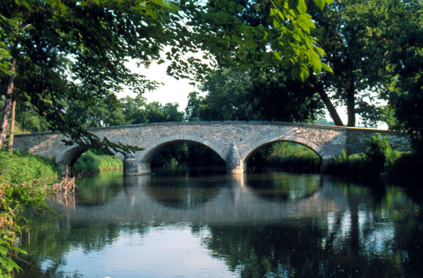
ex image cBurnside's Bridge in Washington County, site of heavy combat during theBattle of Antietam .|Washington County is a
county located in the western part of theU.S. state ofMaryland , bordering SouthernPennsylvania to the north,Northern Virginia to the south, and theEastern Panhandle ofWest Virginia to the south and west. In 2007, its population was 145,113 [ [http://factfinder.census.gov/servlet/SAFFPopulation?_event=ChangeGeoContext&geo_id=05000US24043&_geoContext=&_street=&_county=washington+county%2C+maryland&_cityTown=washington+county%2C+maryland&_state=&_zip=&_lang=en&_sse=on&ActiveGeoDiv=&_useEV=&pctxt=fph&pgsl=010&_submenuId=population_0&ds_name=null&_ci_nbr=null&qr_name=null®=null%3Anull&_keyword=&_industry=] , U.S. Census Bureau, 2007. Retrieved 2008.] . Washington County was the first county in theUnited States to be named for the Revolutionary War general (and later President)George Washington . Itscounty seat is Hagerstown.Washington County is one of three counties in the Hagerstown-Martinsburg, MD-WV Metropolitan Statistical Area. Due to commuting patterns, a high growth rate, and close proximity, Washington County is also often considered, though not officially designated a part of the Washington-Baltimore-Northern Virginia, DC-MD-VA-WV Combined Statistical Area.
History
The western part of Maryland (including the present Washington County) was incorporated into Prince George's County in 1696. This county included six current counties, and by repeated splitting, new ones were generated. The first was Frederick from Prince George's in 1748.
Washington County was formed on October 1, 1776 by the splitting of Frederick County. At the same time, another county, Montgomery County, was also split off from Frederick County and named for another general,
Richard Montgomery . Washington County as created included the areas later to become Allegany County (split off in 1789) and Garrett County (included in Allegany County when it was split off in 1789, later split from Allegany County), so included the entire westernmost part of the state of Maryland [ [ [http://genealogytrails.com/mary/washington/] , Washington County, Maryland History and Genealogy, 2006. Retrieved 2008.] .Geography
According to the U.S. Census Bureau, the county has a total area of 468
square mile s (1,211km² ), of which, 458 square miles (1,187 km²) of it is land and 9 square miles (24 km²) of it (2.01%) is water. Washington County is bordered to the north by theMason-Dixon Line ; to the south by thePotomac River ; to the east bySouth Mountain ; and to the west bySideling Hill Creek .Adjacent counties
*Fulton County,
Pennsylvania (northwest)
*Allegany County (west)
*Morgan County,West Virginia (southwest)
*Berkeley County,West Virginia (south)
*Jefferson County,West Virginia (south)
*Loudoun County,Virginia (southeast)
*Frederick County (east)
*Franklin County,Pennsylvania (northeast)Highways
*
*
*
*
*
*
*
*
*
*
*
*
*
*
*
*
*
*
*
*
*
*
*
*
*
*
*
*
*
*Law and government
County government
Washington County's 'leader' is known as the County Administrator. Currently, Greg Murray serves as the Administrator. However, Washington County's County Commissioners exercise executive powers as they exist in the government of the county.
The County Commissioners in Washington County comprise the traditional form of county government in Maryland. Current members include: Kristin B. Aleshire, Terry Baker, John F. Barr, James F. Kercheval, and William J. Wivell.
tate representation
Washington County is represented by two senators in
Maryland State Senate . MemberDonald F. Munson (R), serves the 2nd district in Maryland andAlex X. Mooney serves in the 3rd district. The county also is represented inMaryland General Assembly 's other primary division, theMaryland House of Delegates . Delegates who stand for Washington County include:LeRoy Myers (R) for District 1C,Andrew A. Serafini (R) for District 2A,Chris Shank (R) for District 2B,John P. Donoghue (D) for District 2C, andRichard Weldon (R) for District 3B.Federal representation
The county is located within
Maryland's 6th congressional district . The representative of the district currently isRoscoe Bartlett (R).Demographics
As of the
census GR|2 of 2000, there were 131,923 people, 49,726 households, and 34,112 families residing in the county. Thepopulation density was 288 people per square mile (111/km²). There were 52,972 housing units at an average density of 116 per square mile (45/km²). The racial makeup of the county was 89.71% White or Caucasian, 7.77% Black or African American, 0.18% Native American, 0.80% Asian, 0.04% Pacific Islander, 0.46% from other races, and 1.04% from two or more races. 1.19% of the population were Hispanic or Latino of any race. 32.1% were of German, 21.4% American, 8.8% Irish and 8.4% English ancestry according toCensus 2000 .There were 49,726 households out of which 31.30% had children under the age of 18 living with them, 54.00% were married couples living together, 10.70% had a female householder with no husband present, and 31.40% were non-families. 26.00% of all households were made up of individuals and 11.10% had someone living alone who was 65 years of age or older. The average household size was 2.46 and the average family size was 2.96.
In the county the population was spread out with 23.40% under the age of 18, 8.10% from 18 to 24, 31.30% from 25 to 44, 23.00% from 45 to 64, and 14.20% who were 65 years of age or older. The median age was 37 years. For every 100 females there were 104.50 males. For every 100 females age 18 and over, there were 104.00 males.
The median income for a household in the county was $40,617, and the median income for a family was $48,962. Males had a median income of $34,917 versus $24,524 for females. The
per capita income for the county was $20,062. About 7.00% of families and 9.50% of the population were below thepoverty line , including 12.30% of those under age 18 and 9.50% of those age 65 or over.Communities
Washington County contains the following incorporated municipalities:
* 1 City:
*#Hagerstown (incorporated 1813)* 8 Towns:
*#Boonsboro
*#Clear Spring
*#Funkstown
*#Hancock
*#Keedysville
*#Sharpsburg
*#Smithsburg
*#WilliamsportUnincorporated areas are also considered as towns by many people and listed in many collections of towns, but they lack local government. Various organizations, such as the
United States Census Bureau , theUnited States Postal Service , and local chambers of commerce, define the communities they wish to recognize differently, and since they are not incorporated, their boundaries have no official status outside the organizations in question. The Census Bureau recognizes the followingcensus-designated place s in the county:#Cavetown
#Chewsville
#Fort Ritchie
#Fountainhead-Orchard Hills (a combination of the communities of Fountainhead and Orchard Hills recognized as a unit by the Census Bureau)
#Halfway
#Highfield-Cascade (a combination of the communities of Highfield and Cascade recognized as a unit by the Census Bureau)
#Leitersburg
#Maugansville
#Mount Aetna
#Mount Lena
#Paramount-Long Meadow (a combination of the communities of Paramount and Long Meadow recognized as a unit by the Census Bureau)
#Robinwood
#Rohrersville
#Saint James
#San Mar
#Wilson-Conococheague (a combination of the communities of Wilson and Conococheague recognized as a unit by the Census Bureau)Other unincorporated areas not listed as CDP's include:
#Beaver Creek
#Big Pool
#Cearfoss
#Downsville
#Fairplay
#Huyett
#Indian Springs
#Mercersville
#PenMar
#Van Lear
#WevertonParks and recreation
National parks
*
Antietam National Battlefield
*Appalachian National Scenic Trail
*Chesapeake and Ohio Canal National Historical Park
*Harpers Ferry National Historical Park tate parks
*
Fort Frederick State Park
*Fort Tonoloway State Park
*Gathland State Park
*Greenbrier State Park
*South Mountain State Park
*Washington Monument State Park Other recreation
*
Crystal Grottoes , the only show caves in Maryland.
*Sideling Hill man-made mountain pass on Interstate 68/U.S. Route 40 roughly 5 miles west of Hancock shows off 100 million years+ of rock formation with Information Center and walkways on the premises.
*Stoney Creek Farm
* [http://www.ruralheritagemuseum.org/ Washington County Rural Heritage Museum]Education
Washington County Public Schools administers public schools in the county. See [http://www.wcboe.k12.md.us/content/ab_schdirectory.cfm "Washington County Public Schools - School Directory"] for a detailed listing of elementary, middle, high, and other schools.High schools
Public high schools
*Antietam Academy , Hagerstown
*Barbara Ingram School for the Arts , Hagerstown
*Boonsboro High School , Boonsboro
*Clear Spring High School , Clear Spring
*Evening High School , Hagerstown
*Hancock High School, Hancock
*North Hagerstown High School , Hagerstown
*Smithsburg High School , Smithsburg
*South Hagerstown High School , Hagerstown
*Washington County Technical High School , Hagerstown
*Williamsport High School , WilliamsportPrivate high schools
*Broadfording Academy, Hagerstown
*Gateway Academy, Williamsport
*Grace Academy, Hagerstown
*Heritage Academy, Hagerstown
*Highland View Academy, Hagerstown
*St. James School, Saint James
*St. Maria Goretti High School, Hagerstown
*Truth Christian Academy, HagerstownColleges and universities
*
University System of Maryland at Hagerstown , a branch of the University of Maryland offering various associate's, bachelor's, and master's degree programs in connection with other state colleges and universities in Maryland.
*Hagerstown Community College *
Kaplan College , formerly known as Hagerstown Business College.*
Mount Saint Mary's University , Hagerstown Campus, offers Masters of Business Administration (MBA) degrees.Notable residents and natives
* See .
References
External links
* [http://www.washco-md.net/ Washington County government]
* [http://www.hagerstown.org Hagerstown-Washington County Chamber of Commerce]
* [http://www.marylandmemories.org Hagerstown-Washington County Convention & Visitor's Bureau]
* [http://www.washcolibrary.org/ Washington County Free Library]
* [http://www.whilbr.org/ WHILBR - Western Maryland's Historical Library]
* [http://www.washcolibrary.org/localhistory/newsindex.asp Washington County Free Library - Historic Newspaper Indexing Project]
* [http://www.wcmfa.org/ Washington County Museum of Fine Arts]
Wikimedia Foundation. 2010.