- Chewsville, Maryland
-
Chewsville, Maryland — CDP — Location of Chewsville, Maryland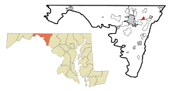
Coordinates: 39°38′35″N 77°38′6″W / 39.64306°N 77.635°WCoordinates: 39°38′35″N 77°38′6″W / 39.64306°N 77.635°W Country United States State Maryland County Washington Area – Total 0.8 sq mi (2.2 km2) – Land 0.8 sq mi (2.2 km2) – Water 0.0 sq mi (0.0 km2) Elevation 636 ft (194 m) Population (2000) – Total 293 – Density 351.9/sq mi (135.9/km2) Time zone Eastern (EST) (UTC-5) – Summer (DST) EDT (UTC-4) ZIP code 21721 Area code(s) 301 FIPS code 24-16800 GNIS feature ID 0591703 Chewsville is a census-designated place (CDP) in Washington County, Maryland, United States. The population was 293 at the 2000 census.
Geography
Chewsville is located at 39°38′35″N 77°38′6″W / 39.64306°N 77.635°W (39.643149, -77.635032)[1].
According to the United States Census Bureau, the CDP has a total area of 0.8 square miles (2.1 km2), all of it land.
Demographics
As of the census[2] of 2000, there were 293 people, 117 households, and 74 families residing in the CDP. The population density was 351.9 people per square mile (136.3/km²). There were 125 housing units at an average density of 150.1/sq mi (58.1/km²). The racial makeup of the CDP was 98.98% White, 0.34% Asian, and 0.68% from two or more races.
There were 117 households out of which 29.9% had children under the age of 18 living with them, 51.3% were married couples living together, 7.7% had a female householder with no husband present, and 35.9% were non-families. 29.1% of all households were made up of individuals and 9.4% had someone living alone who was 65 years of age or older. The average household size was 2.50 and the average family size was 3.15.
In the CDP the population was spread out with 29.0% under the age of 18, 6.5% from 18 to 24, 30.0% from 25 to 44, 22.5% from 45 to 64, and 11.9% who were 65 years of age or older. The median age was 37 years. For every 100 females there were 98.0 males. For every 100 females age 18 and over, there were 94.4 males.
The median income for a household in the CDP was $28,482, and the median income for a family was $31,302. Males had a median income of $26,250 versus $24,844 for females. The per capita income for the CDP was $12,617. About 22.7% of families and 22.7% of the population were below the poverty line, including 44.2% of those under the age of eighteen and 51.3% of those sixty five or over.
References
- ^ "US Gazetteer files: 2010, 2000, and 1990". United States Census Bureau. 2011-02-12. http://www.census.gov/geo/www/gazetteer/gazette.html. Retrieved 2011-04-23.
- ^ "American FactFinder". United States Census Bureau. http://factfinder.census.gov. Retrieved 2008-01-31.
Municipalities and communities of Washington County, Maryland City 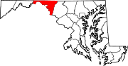
Towns Boonsboro | Clear Spring | Funkstown | Hancock | Keedysville | Sharpsburg | Smithsburg | Williamsport
CDPs Cavetown | Chewsville | Fort Ritchie | Fountainhead-Orchard Hills | Halfway | Highfield-Cascade | Leitersburg | Maugansville | Mount Aetna | Mount Lena | Paramount-Long Meadow | Robinwood | Rohrersville | St. James | San Mar | Wilson-Conococheague
Other
communitiesAntietam | Beaver Creek | Benevola | Big Pool | Broadfording | Brownsville | Burtner | Cearfoss | Cedar Grove | Dargan | Downsville | Eakles Mills | Fairplay | Fairview | Gapland | Huyett | Indian Springs | Jugtown | Mapleville | Mercersville | Park Hall | Pecktonville | Pen Mar | Pinesburg | Ringgold | Samples Manor | Sandy Hook | Spielman | Trego | Van Lear | Weverton | Woodmont
Categories:- Unincorporated communities in Maryland
- Populated places in Washington County, Maryland
- Census-designated places in Maryland


Wikimedia Foundation. 2010.