- Maryland Route 60
-
Maryland Route 60
Route information Maintained by MDSHA Length: 7.27 mi[1] (11.70 km) Major junctions West end: Northern Avenue in Hagerstown  MD 62 in Leitersburg
 MD 418 in Leitersburg
East end:  PA 316 near Leitersburg
Location Counties: Washington Highway system Maryland highway system
Interstate • US • State • Minor • Former • Turnpikes←  MD 59
MD 59MD 61  →
→Maryland Route 60 (MD 60) is a state highway in the U.S. state of Maryland. Known for most of its length as Leitersburg Pike, the state highway runs 7.27 miles (11.70 km) from the intersection of Potomac Street and Northern Avenue in Hagerstown east to the Pennsylvania state line near Leitersburg, where the highway continues as Pennsylvania Route 316 (PA 316). MD 60 connects Hagerstown with Leitersburg and Waynesboro, Pennsylvania. MD 60 was paved over the course of an old turnpike from Hagerstown toward Waynesboro in the mid 1920s. The state highway was reconstructed in the mid 1950s, including the highway's bypass of Leitersburg.
Contents
Route description
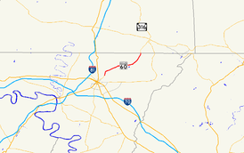
MD 60 begins at an intersection with Northern Avenue, Eastern Boulevard, and Potomac Avenue in the city of Hagerstown. Northern Avenue heads west past St. Maria Goretti High School. Eastern Boulevard heads east toward the historic home Rockland Farm. Potomac Street heads south toward downtown Hagerstown, passing through the Oak Hill and Potomac-Broadway historic districts and by the Zion Reformed United Church of Christ and the Hagerstown Armory. MD 60 heads north as Potomac Avenue, leaving the city limits of Hagerstown before reaching a junction with Marsh Pike, which heads north toward the suburbs of Paramount and Long Meadow. MD 60 continues northeast as Leitersburg Pike through farmland, passing the Dorsey-Palmer House before crossing Marsh Run.[1][2]
MD 60 crosses Antietam Creek and passes the Lantz-Zeigler House before reaching Leitersburg. The state highway intersects MD 62 (Little Antietam Road) on the west side of the unincorporated village before curving to the north to bypass the village while Leiter Street, the old alignment of MD 60, continues straight to pass through the Leitersburg Historic District. North of the village center, MD 60 intersects Leiters Mill Road and the western end of MD 418 (Ringgold Pike), then curves north and receives the other end of Leiter Street. The state highway starts to parallel Antietam Creek as it reaches its eastern terminus at the Pennsylvania state line. The highway continues north as PA 316 (Wayne Highway) toward Waynesboro.[1][2]
History
The predecessor highway of MD 60 was the Hagerstown and Waynesboro Turnpike, which ran from Hagerstown to the Pennsylvania state line via Leitersburg.[3] MD 60 was paved as a modern highway from Hagerstown to Leitersburg in 1923 and from Leitersburg to the state line by 1927.[4][5] The first relocation of MD 60 occurred in 1941 when the highway's bridge over Antietam Creek was replaced.[6] The state highway was reconstructed from its western terminus to the western end of the Antietam Creek relocation in 1952.[7] The segment of MD 60 between Antietam Creek and Leitersburg was rebuilt in 1953 and 1954.[8] The bypass of Leitersburg was constructed and the highway north to the state line was reconstructed between 1954 and 1956.[9]
Junction list
The entire route is in Washington County.
Location Mile[1] Destinations Notes Hagerstown 0.00 Northern Avenue west / Eastern Boulevard south / Potomac Avenue south Western terminus Leitersburg 4.83 MD 62 south (Little Antietam Road) – Chewsville5.35 MD 418 east (Ringgold Pike) – Ringgold7.27 PA 316 (Wayne Highway) – WaynesboroEastern terminus; Pennsylvania state line 1.000 mi = 1.609 km; 1.000 km = 0.621 mi Auxiliary route
MD 60A is the designation for the unnamed 0.10-mile (0.16 km) one-lane ramp from eastbound MD 60 to eastbound MD 418 in Leitersburg.[1][10]
References
- ^ a b c d e "Highway Location Reference: Washington County" (PDF). Maryland State Highway Administration. 2009. http://www.marylandroads.com/Location/2009_WASHINGTON.pdf. Retrieved 2010-11-19.
- ^ a b Google, Inc. Google Maps – Maryland Route 60 (Map). Cartography by Google, Inc. http://maps.google.com/maps?f=d&source=s_d&saddr=Leitersburg+Pike&daddr=MD-60+N%2FLeitersburg+Pike&hl=en&geocode=FVwwXQIdBl9e-w%3BFagVXgIdatZf-w&mra=ls&sll=39.69101,-77.65316&sspn=0.060631,0.154324&ie=UTF8&t=h&z=13. Retrieved 2010-11-19.
- ^ Clark, William Bullock (1899). Report on the Highways of Maryland. Baltimore: Maryland Geological Survey. p. 251. http://books.google.com/books?id=b9l9AAAAIAAJ&printsec=frontcover#v=onepage&q&f=false. Retrieved 2010-11-19.
- ^ Maryland Geological Survey. Map of Maryland: Showing State Road System and State Aid Roads (Map) (1923 ed.).
- ^ Maryland Geological Survey. Map of Maryland: Showing State Road System and State Aid Roads (Map) (1927 ed.).
- ^ Report of the State Roads Commission of Maryland. 1941-1942. Baltimore: Maryland State Roads Commission. 1943-03-15. p. 101. http://www.archive.org/details/reportofstateroa1941mary. Retrieved 2010-11-19.
- ^ Report of the State Roads Commission of Maryland. 1951-1952. Baltimore: Maryland State Roads Commission. 1952-12-15. p. 190. http://www.archive.org/details/reportofstateroa1951mary. Retrieved 2010-11-19.
- ^ Report of the State Roads Commission of Maryland. 1953-1954. Baltimore: Maryland State Roads Commission. 1954-11-12. p. 206. http://www.archive.org/details/reportofstateroa1953mary. Retrieved 2010-11-19.
- ^ Report of the State Roads Commission of Maryland. 1955-1956. Baltimore: Maryland State Roads Commission. 1956-11-02. p. 192. http://www.archive.org/details/reportofstateroa1955mary. Retrieved 2010-11-19.
- ^ Google, Inc. Google Maps – Maryland Route 60A (Map). Cartography by Google, Inc. http://maps.google.com/maps?f=d&source=s_d&saddr=Ringgold+Pike&daddr=Ringgold+Pike&hl=en&geocode=Ff-zXQId1ZZf-w%3BFeC1XQIdNpxf-w&mra=ls&sll=39.695845,-77.620313&sspn=0.001895,0.004823&ie=UTF8&ll=39.695713,-77.621289&spn=0.001895,0.004823&t=h&z=18. Retrieved 2010-11-19.
External links
Roads in Washington County, Maryland State highways 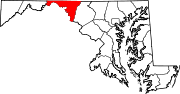
U.S. Highways Interstate Highways Categories:- State highways in Maryland
- Roads in Washington County, Maryland


Wikimedia Foundation. 2010.