- Interstate 70 in Maryland
Infobox road
state=MD
maint=MDSHA, Baltimore DOT
route=70
type=I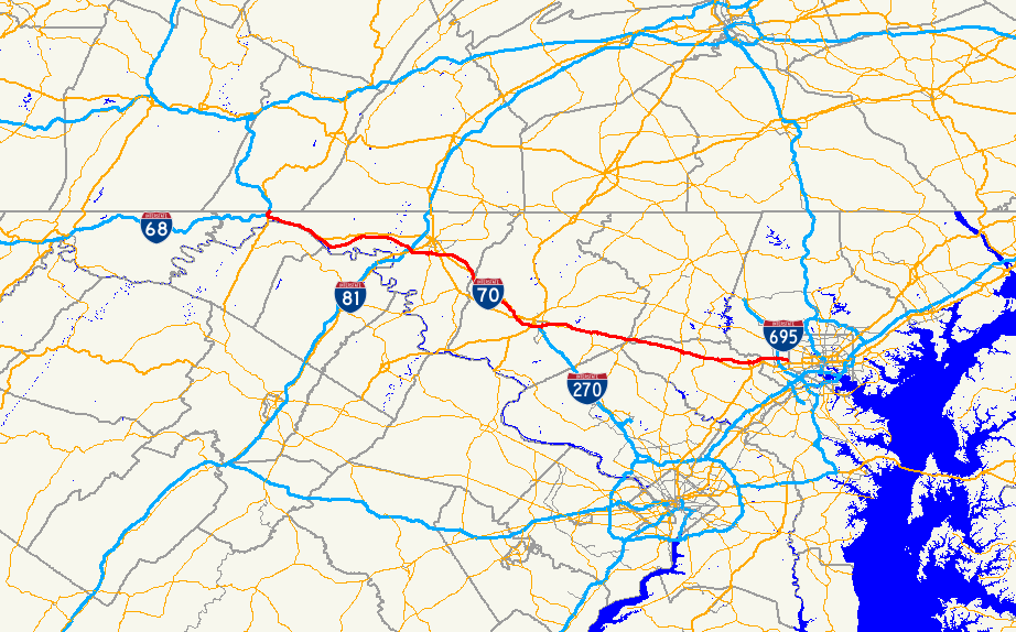
length_mi=93.62
length_round=2
length_ref= [http://www.sha.state.md.us/KeepingCurrent/performTrafficStudies/dataAndStats/hwyLocationRef/oppe/hlr.asp]
established=1956 (completed 1992)
direction_a=West
terminus_a=Jct|state=PA|I|70 atPennsylvania state line
junction=Jct|state=MD|I|68 in Hancock
Jct|state=MD|US|40 in Hancock
Jct|state=MD|US|522 in Hancock
Jct|state=MD|I|81 in Hagerstown
Jct|state=MD|US|40 in Hagerstown
Jct|state=MD|US-Alt|40|dab1=Hagerstown–Frederick, in Frederick
Jct|state=MD|US|15|US|340 in Frederick
Jct|state=MD|I|270 in Frederick
Jct|state=MD|US|40 near West Friendship
Jct|state=MD|US|29 near Ellicott City
Jct|state=MD|I|695 near Baltimore
direction_b=East
terminus_b=Jct|state=MD|MD|122 in Woodlawn
previous_type=MD
previous_route=69
next_type=MD
next_route=70Interstate 70 inMaryland is a major east-west highway that runs from thePennsylvania state line near Hancock east across the central portion of the state towards Baltimore, following the route of theNational Road (now known as U.S. 40). It is the major east-west highway in the state and serves (along withInterstate 68 ) as a major route into theMidwest .Counties traversed
*Washington County
*Frederick County
*Carroll County
*Howard County
*Baltimore CountyCities and towns
I-70 directly serves the following cities and towns (bolded entries are control cities):
columns
col1=
*Hancock
*Clear Spring
*Hagerstown
*Myersville
*Frederick
col2=
*New Market
*Mount Airy
*Lisbon
*Cooksville
*West Friendship
col3=
*Ellicott City
*BaltimoreRoute description
Dwight D. Eisenhower Highway
I-70 enters Maryland near the town of Hancock concurrent with U.S. 522. The route immediately encounters
Interstate 68 and U.S. 40 at a directional stack interchange; I-68 reaches its eastern terminus at this interchange, while U.S. 40 merges with I-70 and U.S. 522 diverges. From Hancock east to Frederick, the route is known as the Dwight D. Eisenhower Highway, a name it gained by an act of Congress in 1973.Federal Highway Administration. [http://www.fhwa.dot.gov/infrastructure/ddehwy.htm Dwight D. Eisenhower Highway] URL accessed 12:56, 21 January 2007.]Bypassing Hancock to the north, U.S. 40 soon departs from I-70 and continues parallel to the former, which follows the
National Road . I-70 continues east and soon reaches Hagerstown, interchanging with Interstate 81 and U.S. 40. Beyond Hagerstown, the route continues east pastGreenbrier State Park , crossing South Mountain (elevation 1,220 feet) andCatoctin Mountain (signed as Braddock Mountain), at an elevation of [http://www.aaroadtrips.com/maryland050/i-070_wb_exit_042_03.jpgconvert|985|ft|m above sea level] . Between the two ridges, I-70 runs east through a wide corridor bordered on the north by U.S. 40 and on the south by Alt U.S. 40. Near the midpoint between the two mountains, I-70 passes to the south of Myersville, interchanging with MD 17 just beyond the town's southern boundary.During the highway's descent from the mountains it encounters U.S. 40 for the third time as it enters the city of Frederick. Continuing east the route enters the [http://maps.google.com/?ie=UTF8&z=15&ll=39.400984,-77.433529&spn=0.017543,0.038238&t=h&om=1 Frederick Triangle] , a triplet of closely spaced interchanges in the shape of a triangle. In the space of a few miles, I-70 interchanges with U.S. 15, U.S. 340, Interstate 270 (which terminates at I-70 and directly connects to U.S. 15 at the third interchange of the Triangle) and U.S. 40, which merges with I-70 again within the interchange complex. The site of the I-270 split (originally a partial interchange, later upgraded by MDOT SHA) was originally the site of I-70's division into I-70N (now I-70) and I-70S (now I-270). Beyond I-270, I-70 now follows the Frederick Bypass, a 1950s-era freeway bypass built for U.S. 15/U.S. 40 through traffic that was and is being reconstructed to increase its capacity.
Korean War Veterans Highway
The entire convert|40|mi|km of Interstate 70 in Frederick County was recently designated the Korean War Veterans Highway.Dishneau, David. [http://www.washtimes.com/metro/20040502-120015-8713r.htm "The Washington Times": I-70 tribute to Korean War vets] URL accessed 15:15, 20 January 2007.] The designation was sought by a local resident named Charles R. "Buck" Wisner, who wished to create a lasting memorial of the 26 local citizens who died during the
Korean War . Initially he sought to designate all convert|93.62|mi|km of I-70 as the Korean War Veterans Highway, but in 2002 the Maryland General Assembly passed a bill applying the designation to the Frederick County section only. Nine other highways in Maryland are also dedicated to Korean War veterans.The two monuments, which display the new name and a granite geographical representation of Korea, are placed at the county borders near Myersville and Mount Airy; the eastern monument lies within the MD 27 interchange.
Baltimore National Pike
Beyond Frederick at Exit 56, I-70 soon reaches the newest portion of the Interstate, built in the 1980s to bypass an old expressway portion of U.S. 40 (now part of MD 144). At Exit 59, I-70 returns to this alignment, built in the 1950s for U.S. 40 as a four-lane divided expressway and fully upgraded by the mid-1970s east of Exit 59. This segment of the Interstate is known as the Baltimore National Pike. Following this alignment, I-70 passes close to the towns of New Market, Mount Airy, Lisbon, Cooksville, and West Friendship. This segment is closely paralleled by one of the incarnations of MD 144, known locally as Frederick Road.
One notable landmark along this segment is the [http://www.howardcountyfair.com/ Howard County Fairground] . The fairground lies right on the southern border of the highway and is readily visible [http://www.aaroadtrips.com/maryland050/i-070_wb_exit_078_04a.jpg] to drivers in both directions.
The route into Baltimore
Near West Friendship, U.S. 40 diverges from I-70 for the final time, with I-70 turning onto a new alignment constructed in the mid-1960s, and U.S. 40 continuing as the Baltimore National Pike (it later becomes Edmondson Avenue in southwest Baltimore). Continuing east past the
Turf Valley Country Club , the Interstate bypasses the built-up portions of U.S. 40 withinEllicott City , interchanging with U.S. 29 north of the city. Despite this segment's proximity to many suburban neighborhoods, it remains at its original width of four lanes (six lanes east of US-29).After crossing the
Patapsco River within thePatapsco Valley State Park , the route eventually reaches Interstate 695, theBaltimore Beltway .I-70 enjoys a (mostly) symmetrical four-level stack interchange with the Beltway; this interchange has the dubious distinction of being underwhelmed with traffic, except for the ramp connecting east bound I-70 to the northbound Beltway. This ramp was a serious bottleneck for inbound traffic, particularly in the evening rush hour, causing backups that sometimes reached as far back as the Patapsco River crossing. In 2006, this ramp was widened to two lanes, but due to the narrowness of the ramps and the location of bridge piers on either side of this ramp, the second lane is very short, which causes backups to persist because everyone must merge into one lane before the ramp crosses the Beltway.
After the Beltway interchange I-70 only runs for another three miles (5 km) before coming to an ignominious end at MD 122 Security Boulevard, on top of the Baltimore city line at the western border of
Leakin Park . At the border, the mainline lanes are used as aPark and Ride , and a reversing loop, built originally for buses serving the Park and Ride, allows travelers to reverse direction and return to I-695, or exit at Cooks Lane to head directly into Baltimore City viaEdmondson Avenue (U.S. 40). Signage on I-70 west of Exit 91 proclaims that the Interstate ends at I-695. [http://www.aaroadtrips.com/maryland050/i-070_eb_exit_091_01.jpg]ervice areas
I-70 has two service areas on South Mountain, one per direction, near the summit. [ [http://maps.google.com/?ie=UTF8&om=1&z=15&ll=39.525329,-77.602186&spn=0.017511,0.038238&t=h Google Maps ] ] The service area is located at
milepost 39 and offers restrooms, phones,picnic table s,vending machine s, an RV dumping station at the eastbound service area, and facilities for the handicapped. [http://www.roadnotes.com/interstate/md.htm RoadNotes - Rest Areas and Welcome Centers in Maryland] URL accessed 07:40, 26 January 2007] Both are maintained by theMaryland State Highway Administration and can be reached by telephone. [http://www.sha.state.md.us/keepingcurrent/maintainRoadsBridges/OED/roads/restarea.asp MDSHA: Maryland Welcome Centers and Rest Areas] URL accessed 07:45, 26 January 2007] "Beltway snipers"Lee Boyd Malvo andJohn Allen Mohammed were apprehended while sleeping in their converted car in the westbound Braddock rest area.cite web|author=BBC News |title=Police arrest sniper suspects|url=http://news.bbc.co.uk/2/hi/americas/2359017.stm|year=2002|accessdate=2008-07-25] These rest areas are currently closed, because their facilities are being torn down and rebuilt entirely. They are scheduled to reopen in 2009.Points of interest
*
Fort Tonoloway State Park
*Fort Frederick State Park
*Hagerstown Roundhouse Museum
*South Mountain
* [http://www.dnr.state.md.us/publiclands/western/greenbrier.html Greenbrier State Park]
*Gambrill State Park
*Braddock Heights, Maryland
*Historic Frederick
* [http://bridge.skyline.net/ Frederick Community Bridge]
*Monocacy National Battlefield
*Historic New Market
* [http://www.adventureparkusa.com/ Adventure Park USA]
* [http://www.pickyourown.com/ Larriland Farm]
* [http://www.dnr.state.md.us/publiclands/central/patuxentriver.html Patuxent River State Park]
* [http://www.howardcountyfair.com/ Howard County Fairground]
*Historic Ellicott City
* [http://www.dnr.state.md.us/publiclands/central/patapscovalley.html Patapsco Valley State Park]
* [http://leakinpark.com/newsite/ Leakin Park]
* [http://www.gwynnsfallstrail.org/ Gwynns Falls Trail] (by spring 2007)Auxiliary routes
I-70 has two auxiliary routes in Maryland:
*Interstate 270, the Eisenhower Memorial Highway to
Washington D.C.
*Interstate 370, a tertiary spur into Shady Grove Metro station.Exit list
Exits are numbered from west to east, in accordance with
AASHTO guidelines.History
The first sections of I-70 to appear in Maryland were a segment near Hancock and the original Frederick Bypass, both completed in 1961. By the mid-1960s, I-70 had been completed between Frederick and Hagerstown.
I-70N
I-70 east of Frederick was originally designated I-70N. At
Frederick, Maryland , I-70 split into two branches: I-70N, which led into Baltimore, and I-70S (now I-270), which took a path into theWashington, D.C. area. I-70N never existed as a complete Frederick-Baltimore route; the eastern two miles (3 km) of the old Frederick Bypass and the ten miles (16 km) between the U.S. 40 wye near West Friendship (Exit 82) and Interstate 695 (Exit 91), completed in 1968 (and extended to MD 122 in 1970) were the only portions of I-70N that ever existed. I-70N was changed to I-70 in 1975, during the upgrade of the 1950s era Baltimore National Pike between Exit 59 and Exit 82.Kozel, Scott M. [http://www.roadstothefuture.com/I270_I370.html I-270 and I-370 in Maryland] URL accessed 13:35, 17 January 2007.]Scott Kozel, the noted highway historian, believes that the state of Maryland chose to change I-70N to I-70 because the former was an east-west through route that served central Maryland and Baltimore, while I-70S was more of a northwest-southeast route better suited as a commuter route for travelers headed for the Capital Beltway and
Washington D.C. There are signs along U.S. 40 in Baltimore that still depict the I-70 freeway as I-70N. Trucks are directed onto it via I-695.
I-70 in Baltimore
I-70 was originally supposed to continue to downtown Baltimore. Due to opposition from communities, the plan was modified for the highway to run through
Leakin Park andGwynns Falls Park to reach Interstate 95 near Caton Ave. Further opposition led to the cancellation of the route in 1982, truncating the Interstate at the Baltimore City line, just beyond MD 122. Today, only convert|0.14|mi|km of I-70 exists within the city.Current and future road works
Patuxent Freeway
The interchange between I-70 and MD 32 is due to be improved within the next five years, as part of a major widening of the latter between the Interstate and MD 108. MD 32 already serves as a major connector between central Maryland, I-95, and Annapolis, acting as an outer bypass of both Baltimore and Washington; the improvement of the interchange will provide free-flowing access between I-70 and MD 32.
I-70 in Frederick
The entire length of I-70 in Frederick, from the western corporate limits near Exit 52 to MD 144 at Exit 56, has been the subject of a three-decade planning study that began in 1978. The study has so far resulted in the addition of ramps at the U.S. 15/U.S. 340 interchange and the I-270 interchange, thw widening of the mainline bridges through the latter interchange to support three lanes per direction, and the ongoing reconstruction of the MD 85/MD 355 interchange at Exit 54. Further improvements are planned; these improvements include widening I-70 between Exit 53 and Exit 56 to six lanes, removing the westbound ramps at Exit 55, constructioning a westbound entrance ramp at Exit 56, and widening the mainline carriageway to six lanes between Exit 49 and Exit 52, west of Frederick. [http://www.sha.state.md.us/WebProjectLifeCycle/FR427_21/htdocs/Maps/Final_Design/I-70_Project%20Maps.pdf Final Design of I-70 in Frederick] URL accessed 19:38, 23 June 2008.]
This massive project was required due to the aged and substandard infrastructure that I-70 made use of as it descended Braddock Mountain in the early 1960s and linked with the Frederick Freeway, an aged 1950s era bypass that carried U.S. 40 and U.S. 15 through downtown Frederick, with I-70N (as it was then) following the two miles (3 km) formerly used by U.S. 40 east of Exit 53 and I-70S turning south along the Washington National Pike freeway. With the completion of the works sometimes in the next 10 years, I-70 will be upgraded from a cramped, substandard four-lane urban bypass into a modern, six-lane urban Interstate; the route will be a minimum of six lanes for a distance of convert|33|mi|km, from Exit 49 to Exit 82.
Miscellanea
*Near I-70's eastern end
Baltimore, Maryland , a sign announcing the distances toColumbus, Ohio ;St. Louis, Missouri ;Denver, Colorado ; and currently used on most American highway signs.*
Interstate 370 , a short spur route off of I-270 in Gaithersburg, never intersects with I-70, its parent route.*Out of the five counties it travels though, I-70 has the shortest mileage through Carroll County: convert|1.6|mi|km.
ee also
*
Interstate 68
*Interstate 270
*Interstate 370
*U.S. Route 40
*U.S. Route 40 AlternateReferences
External links
* [http://www.mdroads.com/routes/is070.html I-70 @ MDRoads.com]
* [http://www.roadstothefuture.com/I70_Leakin_Park.html "Roads to the Future": I-70 in Leakin Park]
* [http://www.kurumi.com/roads/3di/balto.html Good map of the existing and proposed aspects of Baltimore's highway systems]
Wikimedia Foundation. 2010.