- Maryland Route 27
-
This article is about the Maryland state highway. For the Baltimore bus route, see Route 27 (MTA Maryland).
Maryland Route 27

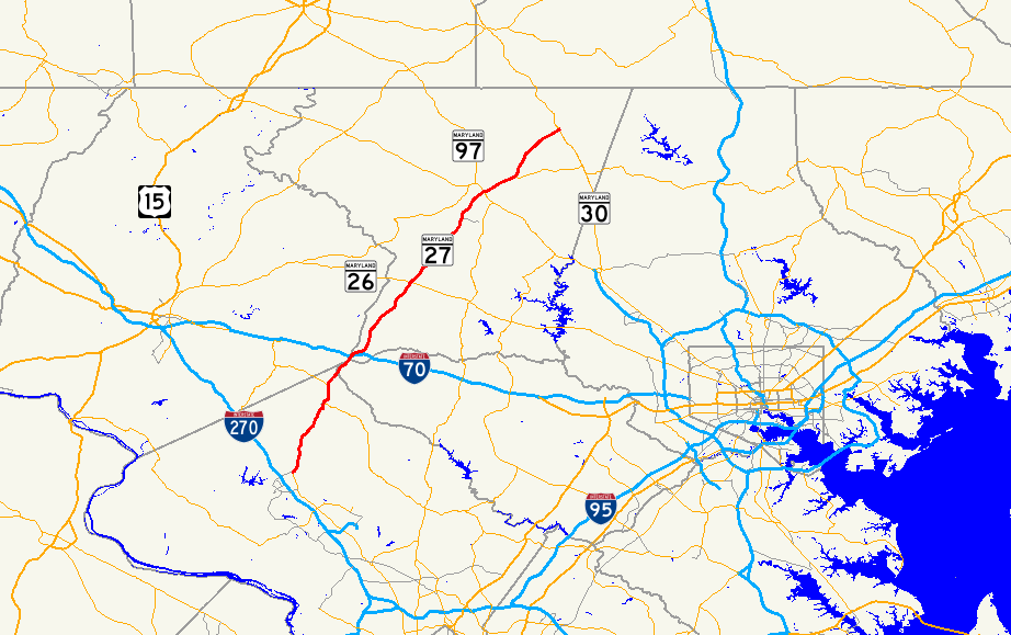
Route information Maintained by MDSHA Length: 39.17 mi[1][2][3] (63.04 km) Major junctions South end:  MD 355 near Germantown
 MD 108 in Damascus
 MD 80 near Damascus

 I-70 / US 40 in Mount Airy
 MD 26 in Taylorsville
 MD 407 near Taylorsville

 MD 140 / MD 97 in Westminster
 MD 482 in Mexico
North end:  MD 30 in Manchester
Location Counties: Montgomery, Howard, Frederick, Carroll Highway system Maryland highway system
Interstate • US • State • Minor • Former • Turnpikes← MD 26MD 28  →
→Maryland Route 27 is a state highway in the central part of the U.S. state of Maryland.
Contents
Route description
MD 27, also known as Ridge Road and Manchester Road (at Northern Point), begins in Germantown at MD 355. Despite signage at I-270 Exit 16, the route does not actually reach the Interstate.
The route runs north through Germantown and Damascus, crossing Frederick, Howard and Carroll counties into Mt. Airy. Remaining in Carroll County, the route runs north, intersecting MD 26 in Taylorsville and eventually reaches Westminster. After running through downtown Westminster and crossing MD 140, the route continues north and ends in Manchester at MD 30.
Junction list
County Location Mile
[1][2][3]Destinations Notes Montgomery Germantown 0.00  MD 355 (Frederick Road) to I-270 / Ridge Road south – Gaithersburg, Clarksburg
Southern terminus Damascus 6.56 MD 108 east (Main Street) – LaytonsvilleMD 27 turns north at this intersection 8.75 MD 80 west (Kemptown Road) – UrbanaHoward Mount Airy No major intersections in Howard County. Montgomery MD-27 re-enters Montgomery County briefly. No intersections. Frederick 11.76  MD 144 east (Old National Pike) – Lisbon
Officially MD 144A Frederick/Carroll 12.17 I-70 (Baltimore National Pike) / US 40 – Frederick, BaltimoreI-70 Exit 68. MD-27 serves as the county line in this area. 12.39 Main Street north to  MD 808 north
East leg of intersection is exit ramp from westbound I-70 Carroll 13.13 Ridgeville Boulevard Old alignment of US 40 15.05 MD 808 south (Main Street) / Leishear RoadOfficially MD 808A Taylorsville 20.65 MD 26 (Liberty Road) – Eldersburg, Libertytown22.73 MD 407 west (Marston Road) – MarstonWestminster 30.41 Main Street Formerly part of MD 32 31.01 MD 140 / MD 97 (Baltimore Boulevard) – Baltimore, Taneytown, GettysburgInterchange 31.78 Old Manchester Road north Unsigned MD 852G Mexico 33.61 MD 482 east (Hampstead Mexico Road) – Hampstead34.04 Old Manchester Road south Unsigned MD 852G Manchester 39.17 MD 30 (Hanover Pike) – Hampstead, HanoverNorthern terminus 1.000 mi = 1.609 km; 1.000 km = 0.621 mi History

The route was originally designated Maryland Route 29 in 1933, with the original route of U.S. Route 29 via Ashton being designated Maryland Route 27. After US 29's arrival in 1934, the two routes swapped numbers, with MD 29 becoming MD 27, and MD 27 becoming MD 29 (and thus being promoted to US 29 without conflict).
At one time, all of MD 27 north of Westminster, as well as a small piece of the former route northeast of Manchester, was part of MD 31.
References
- ^ a b "Highway Location Reference: Montgomery County" (PDF). Maryland State Highway Administration. 2009. http://www.marylandroads.com/Location/2009_MONTGOMERY.pdf. Retrieved 2011-04-21.
- ^ a b "Highway Location Reference: Frederick County" (PDF). Maryland State Highway Administration. 2009. http://www.marylandroads.com/Location/2009_FREDERICK.pdf. Retrieved 2011-04-21.
- ^ a b "Highway Location Reference: Carroll County" (PDF). Maryland State Highway Administration. 2009. http://www.marylandroads.com/Location/2009_CARROLL.pdf. Retrieved 2011-04-21.
External links
Roads in Montgomery County, Maryland Maryland State Highways 
U.S. Routes Interstate Highways Roads by name Cabin John Parkway · Clara Barton Parkway · Cherry Hill Road · Connecticut Avenue · Georgia Avenue · Montrose Road · New Hampshire Avenue · Randolph Road · Sligo Creek Parkway · Wisconsin Avenue · 16th StreetCategories:- State highways in Maryland
- Roads in Montgomery County, Maryland
- Roads in Howard County, Maryland
- Roads in Frederick County, Maryland
- Roads in Carroll County, Maryland


Wikimedia Foundation. 2010.