- Maryland Route 23
-
This article is about the Maryland state highway. For the Baltimore area bus route, see Route 23 (MTA Maryland).
Maryland Route 23
Route information Maintained by MDSHA Length: 20.58 mi[1] (33.12 km) Major junctions East end:  US 1 in Hickory
 MD 24 in Forest Hill
 MD 165 in Jarrettsville
 MD 146 in Madonna
 MD 138 near Shawsville
 MD 439 in Shawsville
 MD 136 in Norrisville
North end:  PA 24 near Norrisville
Location Counties: Harford Highway system Maryland highway system
Interstate • US • State • Minor • Former • Turnpikes←  MD 22
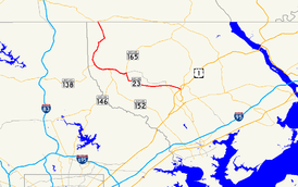
MD 22MD 24 →Maryland Route 23 (MD 23) is a state highway in the U.S. state of Maryland. The state highway runs 20.58 miles (33.12 km) from U.S. Route 1 (US 1) in Hickory north and west to the Pennsylvania state line near Norrisville, where the highway continues as Pennsylvania Route 24 (PA 24). MD 23 is an L-shaped highway in northwestern Harford County that consists of two major sections. Between US 1 and MD 165 in Jarrettsville, MD 23 is marked east–west along a two-lane controlled access road named East–West Highway. From MD 165 to the state line, the state highway is marked north–south along Norrisville Road, a rural two-lane highway that passes through the villages of Madonna and Shawsville. The two sections of MD 23 are connected by a short concurrency with MD 165.
MD 23 from Hickory to Jarrettsville was one of the original state highways marked for improvement by the Maryland State Roads Commission in 1909 and one of the original state-numbered highways in 1927. The state road was constructed from Hickory to Jarrettsville and from Norrisville to the state line in the early to mid-1910s. The gaps between Jarrettsville and Shawsville and from Shawsville to Norrisville were filled in the early 1920s. East–West Highway was constructed in the early 1960s to replace the parallel Jarrettsville Road. MD 23's eastern terminus was moved to US 1's new bypass of Hickory in 2000.
Contents
Route description
MD 23 begins at an intersection with US 1 (Hickory Bypass) in Hickory. The state highway heads west as East–West Highway, a two-lane controlled access highway that parallels the old alignment of MD 23, Jarrettsville Road. MD 23 passes through a commercial area where the highway intersects US 1 Business (Conowingo Road) and Water Tower Way before the highway passes through a narrow forested corridor. The state highway intersects Commerce Road at a roundabout; Commerce Road heads north into an industrial park surrounding Forest Hill Airport. After crossing over Bynum Run and the Ma and Pa Trail, a rail trail along the abandoned right-of-way of the Maryland and Pennsylvania Railroad, MD 23 intersects MD 24 (Rocks Road/Rock Springs Avenue) just south of Forest Hill. MD 23 continues west through a mix of farmland and forest, passing south of the hamlet of Fairview and crossing over Phillips Mill Road and Morse Road before East–West Highway reaches its western terminus at MD 165 (Baldwin Mill Road) south of Jarrettsville.[1][2]
MD 23 turns north and joins MD 165 in a concurrency to the center of Jarrettsville. MD 165 continues north as Federal Hill Road and MD 23 joins its original alignment, which heads east as Jarrettsville Road. MD 23 heads west through farmland as Norrisville Road, where the highway intersects MD 146 (Jarrettsville Pike) and Madonna Road in the village of Madonna. The state highway gradually curves to the north through Shawsville, where MD 23 intersects two highways that head west into Baltimore County, MD 138 (Troyer Road) and MD 439 (Old York Road). The state highway makes a sharp, curvaceous descent to a crossing of Deer Creek, next to which is the historic Ivory Mills complex. MD 23 ascends out of the forested creek valley into Norrisville and meets the north end of MD 136 (Harkins Road). The state highway continues north to just south of the Pennsylvania state line. MD 23 turns west and closely parallels the state line for about 2,000 feet (610 m) before the highway veers northwest to cross the border. The highway continues north as PA 24 (Barrens Road) toward Stewartstown.[1][2]
History
The first section of MD 23 to be paved was the part of the Old York Turnpike from MD 138 to MD 439, which was improved as a 12-foot (3.7 m) wide macadam state-aid road by 1910.[3][4] The portion of MD 23 from Hickory to Jarrettsville was designated one of the original state roads by the Maryland State Roads Commission in 1909.[3] The state road was constructed with a 14-foot (4.3 m) wide macadam surface from Hickory to Grafton Shop Road in 1910, from Morse Road to Jarrettsville in 1914, and between Grafton Shop Road and Morse Road in 1915.[5] Another section of 12-foot (3.7 m) wide macadam road was constructed under state aid from south of Norrisville to the Pennsylvania state line by 1915.[5] The highway from Jarrettsville to MD 138 was under construction as a concrete road by 1919 and completed in 1921.[6][7] The final portion of MD 23, also paved in concrete, was completed from MD 439 to south of Norrisville in 1923.[8] MD 23 was one of the state numbered highways assigned in 1927.[9] The state highway was widened to a width of 20 feet (6.1 m) from Hickory to Jarrettsville by 1930.[10]
Jarrettsville Road was replaced by East–West Highway, which was under construction by 1961 and completed in 1963.[11][12] The MD 23 designation was moved to the new highway and Jarrettsville Road was immediately transferred to county maintenance.[12] At its eastern end, East–West Highway was constructed to tie into the Bel Air Bypass that was completed in 1965 and was proposed to continue to east of Hickory.[13] Close to its eastern end, MD 23 curved south to an intersection with Granary Road. MD 23 turned east onto Granary Road for its eastern terminus at US 1 (now US 1 Business). East–West Highway continued south as MD 23A; at Bynum Road, MD 23A became a one-lane ramp that joined the Bel Air Bypass.[14][15] In 2000, the Hickory Bypass was completed; US 1 was moved to the new bypass and US 1 Business was extended along US 1's old route through Hickory. As part of the same project, MD 23 was extended east to an new terminus at the Hickory Bypass. East–West Highway's curve to the south was replaced with a perpendicular intersection with MD 23A, which was renamed Water Tower Way, extended north to new MD 23, and gained a ramp from northbound US 1 at its southern end. The portion of Granary Road that formed MD 23's terminus was designated MD 23B.[16] Both MD 23A and MD 23B were transferred to Harford County maintenance in 2002.[17] MD 23's roundabout at Commerce Road in Forest Hill was constructed in 2008.[18]
Junction list
MD 23 is signed east–west east of MD 165 and north–south west of MD 165. The mileage below starts from the eastern terminus. The entire route is in Harford County.
Location Mile
[1]Destinations Notes Hickory 0.00 US 1 (Hickory Bypass) – Baltimore, Rising SunEastern terminus 0.22  US 1 Bus. (Conowingo Road) – Bel Air
Forest Hill 1.12 Commerce Road north Roundabout 2.00 MD 24 (Rocks Road/Rock Spring Avenue) – Bel Air, PylesvilleJarrettsville 6.81 MD 165 south (Baldwin Mill Road) – BaldwinSouth end of concurrency with MD 165 8.09 MD 165 north (Federal Hill Road) / Jarrettsville Road east – Pylesville, Forest HillNorth end of concurrency with MD 165; Jarrettsville Road is old alignment of MD 23 Madonna 10.44 MD 146 south (Jarrettsville Pike) / Madonna Road north – JacksonvilleShawsville 12.66 MD 138 west (Troyer Road) / Troyer Road east – Monkton13.88 MD 439 west (Old York Road) – Maryland LineNorrisville 18.58 MD 136 east (Harkins Road) – Whiteford20.58 PA 24 (Barrens Road) – StewartstownNorthern terminus; Pennsylvania state line 1.000 mi = 1.609 km; 1.000 km = 0.621 mi Auxiliary routes
MD 23 previously had two auxiliary routes.
- MD 23A was the designation for the portion of East–West Highway between Granary Road and the ramp to southbound US 1 (Bel Air Bypass). The 0.38-mile (0.61 km) state highway was constructed in the mid 1960s as a connection between MD 23 and southbound US 1.[15] In 2000, MD 23A was extended north to the new MD 23 and a ramp from northbound US 1 to MD 23A was added. The highway had a new length of 0.53 miles (0.85 km) and was renamed Water Tower Way.[16][19] MD 23A was removed from the state highway system in 2002.[17]
- MD 23B was the designation for the 0.16-mile (0.26 km) section of Granary Road between US 1 Business and MD 23A (Water Tower Way) that was part of MD 23 from the construction of East–West Highway in the early 1960s until 2000.[16][20] MD 23B was assigned in 2000 and removed from the state system in 2002.[16][17]
References
- ^ a b c d "Highway Location Reference: Harford County" (PDF). Maryland State Highway Administration. 2009. http://www.marylandroads.com/Location/2009_HARFORD.pdf. Retrieved 2011-02-23.
- ^ a b Google, Inc. Google Maps – Maryland Route 23 (Map). Cartography by Google, Inc. http://maps.google.com/maps?f=d&source=s_d&saddr=MD-23+W&daddr=MD-23+S%2FNorrisville+Rd+to:MD-23+N%2FNorrisville+Rd&hl=en&geocode=FcDJWwIdQPty-w%3BFbx2XAIdLB1w-w%3BFScZXgIdMuxv-w&mra=ls&sll=39.608135,-76.527414&sspn=0.014944,0.038581&ie=UTF8&t=h&z=11. Retrieved 2011-02-23.
- ^ a b Maryland Geological Survey. Map of Maryland (Map) (1910 ed.).
- ^ United States Geological Survey. Parkton, MD quadrangle (Map). 1:48,000. 15 Minute Series (Topographic) (1938 ed.). http://historical.mytopo.com/quad.cfm?quadname=Parkton&state=MD&series=15. Retrieved 2011-02-24.
- ^ a b Report of the State Roads Commission of Maryland. 1912-1915. Baltimore: Maryland State Roads Commission. May 1915. pp. 112, 124. http://www.archive.org/details/annualreportsofs1912mary. Retrieved 2011-02-24.
- ^ Report of the State Roads Commission of Maryland. 1916-1919. Baltimore: Maryland State Roads Commission. January 1920. p. 39. http://www.archive.org/details/annualreportsofs1916mary. Retrieved 2011-02-24.
- ^ Maryland Geological Survey. Map of Maryland: Showing State Road System and State Aid Roads (Map) (1921 ed.).
- ^ Maryland Geological Survey. Map of Maryland: Showing State Road System and State Aid Roads (Map) (1923 ed.).
- ^ Maryland Geological Survey. Map of Maryland: Showing State Road System and State Aid Roads (Map) (1927 ed.).
- ^ Report of the State Roads Commission of Maryland. 1927-1930. Baltimore: Maryland State Roads Commission. 1930-10-01. p. 82. http://www.archive.org/details/reportofstateroa1927mary. Retrieved 2011-02-24.
- ^ "NBI Structure Number: 100000120064010". National Bridge Inventory. http://nationalbridges.com/nbi_record.php?StateCode=24&struct=100000120064010. Retrieved 2011-02-24.
- ^ a b Maryland State Roads Commission. Maryland: Official Highway Map (Map) (1963 ed.).
- ^ Maryland State Roads Commission. Maryland: Official Highway Map (Map) (1965 ed.).
- ^ United States Geological Survey (1986-07-01). 26 km NE of Baltimore, Maryland, United States (Map). Topo Map. http://msrmaps.com/image.aspx?T=2&S=12&Z=18&X=479&Y=5475&W=1&qs=. Retrieved 2011-02-24.
- ^ a b "Highway Location Reference: Harford County" (PDF). Maryland State Highway Administration. 1999. http://www.marylandroads.com/Location/1999_HARFORD.pdf. Retrieved 2011-02-24.
- ^ a b c d "Highway Location Reference: Harford County" (PDF). Maryland State Highway Administration. 2000. http://www.marylandroads.com/Location/2000_HARFORD.pdf. Retrieved 2011-02-24.
- ^ a b c "Highway Location Reference: Harford County" (PDF). Maryland State Highway Administration. 2002. http://www.marylandroads.com/Location/2002_HARFORD.pdf. Retrieved 2011-02-24.
- ^ "Highway Location Reference: Harford County" (PDF). Maryland State Highway Administration. 2008. http://www.marylandroads.com/Location/2008_HARFORD.pdf. Retrieved 2011-02-24.
- ^ Google, Inc. Google Maps – Maryland Route 23A (Map). Cartography by Google, Inc. http://maps.google.com/maps?f=d&source=s_d&saddr=East-West+Hwy&daddr=East-West+Hwy&hl=en&geocode=FUjNWwIdPOJy-w%3BFRWxWwId295y-w&mra=ls&sll=39.56471,-76.357555&sspn=0.007477,0.01929&ie=UTF8&ll=39.567174,-76.357491&spn=0.007477,0.01929&t=h&z=16. Retrieved 2011-02-24.
- ^ Google, Inc. Google Maps – Maryland Route 23B (Map). Cartography by Google, Inc. http://maps.google.com/maps?f=d&source=s_d&saddr=East-West+Hwy&daddr=Granary+Rd&hl=en&geocode=FS7EWwIdHuJy-w%3BFRrEWwIdkO1y-w&mra=ls&sll=39.569126,-76.355839&sspn=0.003738,0.009645&ie=UTF8&ll=39.568175,-76.355635&spn=0.003738,0.009645&t=h&z=17. Retrieved 2011-02-24.
External links
Roads in Harford County, Maryland State highways 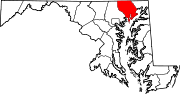
U.S. Highways Interstate Highways Categories:- State highways in Maryland
- Roads in Harford County, Maryland


Wikimedia Foundation. 2010.