- Maryland Route 51
-
Maryland Route 51

Maryland Route 51 highlighted in redRoute information Maintained by MDSHA Length: 25.53 mi[1] (41.09 km) Major junctions West end: 

 I-68 / US 40 / US 220 in Cumberland
 MD 61 in Cumberland
 MD 639 in Evitts Creek
East end:  WV 9 near Paw Paw, WV
Location Counties: Allegany Highway system Maryland highway system
Interstate • US • State • Minor • Former • Turnpikes←  US 50
US 50MD 52  →
→Maryland Route 51 (MD 51) is a state highway in the U.S. state of Maryland. Known for most of its length as Oldtown Road, the state highway runs 25.53 miles (41.09 km) from an interchange with Interstate 68 (I-68) in Cumberland east to the West Virginia state line at the Potomac River, where the highway continues east as West Virginia Route 9 (WV 9) toward Paw Paw. Around Cumberland, MD 51 is a major highway that provides a bypass of the South End neighborhood of that city and access to industrial areas along the Potomac River. East of North Branch, MD 51 is a rural highway connecting small communities along the river in southeastern Allegany County, including Oldtown.
The city streets of Cumberland on which MD 51 was later designated were paved by 1910. The highway was constructed from the city limits of Cumberland to North Branch in the mid 1920s and to Paw Paw in the early 1930s and dedicated as Uhl Highway. Industrial Boulevard, a divided highway in the city of Cumberland, was constructed in the mid 1960s. MD 51 between Evitts Creek and North Branch was relocated in the mid 1980s to better serve nearby industrial properties.
Contents
Route description
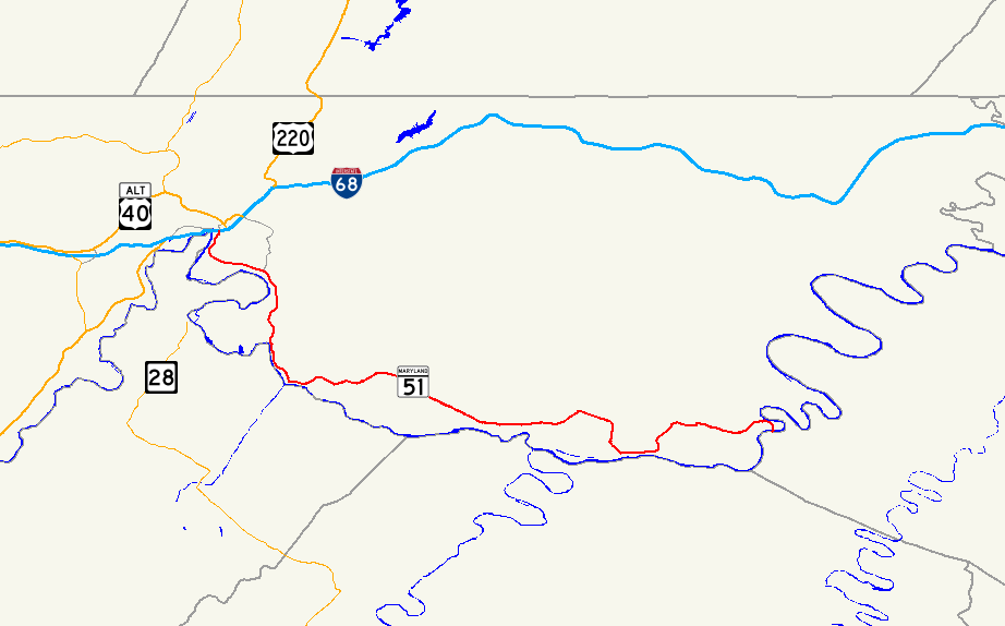
MD 51 begins at an intersection with ramps of I-68 Exit 43B. Mechanic Street heads north from the intersection toward the Downtown Cumberland Historic District, providing access to the western end of the Chesapeake and Ohio Canal National Historical Park (C&O Canal) at Canal Place. A ramp to eastbound I-68 forms the east leg of the intersection, while Howard Street, which receives a ramp from westbound I-68, is the west leg. MD 51 heads south as Industrial Boulevard, a two-lane divided highway. Just south of its terminus, the state highway intersects Winston Street and Queen City Drive and receives a ramp from eastbound I-68. Queen City Drive is used by MD 51 west to access Centre Street, which has a ramp to westbound I-68. South of I-68 and Queen City Drive, MD 51 becomes a six-lane divided highway for a very short distance before Canal Parkway, which is unsigned MD 61, exits eastbound and enters westbound just ahead of a bridge over CSX's Cumberland Terminal Subdivision.[1][2]
MD 51 continues south on the west side of the South End neighborhood of Cumberland as a four-lane divided highway. The state highway turns east and gains a wide median with houses and businesses just before intersecting Virginia Avenue. Southbound Virginia Avenue completes the missing movements from the partial interchange with Canal Parkway, while northbound Virginia Avenue heads through the Chapel Hill Historic District. After the median narrows, MD 51 parallels CSX's Cumberland rail yard. MD 51's name changes to Oldtown Road after intersecting the old alignment with the same name that passes through the South End of Cumberland. Shortly after leaving the city limits of Cumberland, MD 51 crosses Evitts Creek and intersects Messick Road, which is unsigned MD 639, then turns south through the unincorporated community of Evitts Creek, continuing to parallel the rail yard. The state highway reduces to a two-lane road after passing Uhl Highway, an old alignment of MD 51 that is unsigned MD 51E. The rail yard ends at Mexico Farms Road, which provides access to Mexico Farms Airport and the Warrior Run Generating Station. Within the hamlet of North Branch, MD 51 intersects as other end of Uhl Highway as well as Pittsburgh Plate Glass Road, which serves the North Branch Industrial Complex, including Federal Correctional Institution, Cumberland.[1][2]
MD 51 enters a rural area and parallels the C&O Canal southeast through Spring Gap. The state highway turns away from the Potomac River and passes through a hilly area south of Warrior Mountain before entering the valley of Mill Run. MD 51 again parallels the C&O Canal as the highway approaches the unincorporated community of Oldtown. Within Oldtown, the state highway intersects Opessa Street, which leads to a private, low-water toll bridge across the Potomac River to Green Spring Road in Hampshire County, West Virginia.[3] MD 51 separates from the C&O Canal again as it leaves Oldtown and enters the valley of Sawpit Run, which the road follows to its confluence with Town Creek. The state highway follows the creek to the community of Town Creek, where it makes contact with the C&O Canal again. MD 51 then climbs a bluff and turns north again, passing through a swath of Green Ridge State Forest before turning east and settling into the valley of Pursiane Run. The state highway turns north out of the stream valley as it loops east over the C&O Canal and south over the Potomac River into West Virginia, where the highway continues as WV 9 toward Paw Paw.[1][2]
History
Portions of what was to become MD 51 were paved within the city of Cumberland by 1910.[4] The state highway originally began at the intersection of Baltimore Avenue and Front Street. MD 51 followed Park Street, Williams Street, and Louisiana Avenue to Oldtown Road southeast out of the city.[5] The modern state highway was constructed from the Cumberland city line to North Branch by 1923.[6] MD 51 was extended to Spring Gap between 1924 and 1926, including an underpass of the Western Maryland Railway at North Branch.[7][8] Construction was underway between Spring Gap and Oldtown by 1930.[9] MD 51 was completed and marked between Spring Gap and Paw Paw, including the new bridge over the Potomac River near Paw Paw, in 1932.[10][11] In 1934, the highway was named for G. Clinton Uhl, a native of Mount Savage who was chairman of the Maryland State Roads Commission from 1929 until his death in 1934.[10][12]
MD 51 was widened between the city limits of Cumberland and North Branch in 1949 and 1950.[13] A new bridge was constructed over Evitts Creek and the surrounding length of highway widened to three lanes in 1957.[14][15] Industrial Boulevard was constructed from the Cumberland city limit west to the intersection of Mechanic Street and Centre Street in 1964. At the time, the new bypass of the South End of Cumberland was constructed as a divided highway from Oldtown Road to just east of Messick Road.[16] The divided highway was extended to downtown Cumberland after a new bridge over the Baltimore and Ohio Railroad was completed in 1965.[17][18] The divided highway was extended east to its present extent just south of the northern intersection with Uhl Highway in Evitts Creek, part of the relocation of MD 51 through North Branch, in 1987.[19] The present bridge over the Potomac River at Paw Paw was also constructed in 1987.[20]
Junction list
The entire route is in Allegany County.
Location Mile[1] Destinations Notes Cumberland 0.00 Mechanic Street north / I-68 east (National Freeway) / US 40 / US 220 – HancockWestern terminus; I-68 Exit 43B 0.08 Queen City Drive north / Centre Street north to I-68 west (National Freeway) / US 40 / US 220 – FrostburgWestbound exit, eastbound entrance; unsigned MD 51A 0.21 MD 61 south (Canal Parkway) – Wiley Ford, WV, Cumberland Regional AirportEastbound exit, westbound entrance; MD 61 is unsigned 1.24 Virginia Avenue – Wiley Ford, WV, Cumberland Regional Airport 2.54 Oldtown Road west Old alignment of MD 51 Evitts Creek 2.86 MD 639 north (Messick Road) – Allegany College of MarylandMD 639 is unsigned 3.46 Uhl Highway south Unsigned MD 51E 4.31 Blue Valley Road east Unsigned MD 51F North Branch 5.63 Uhl Highway north / Pittsburgh Plate Glass Road west – Mexico Uhl Highway is unsigned MD 51E Oldtown 14.72 Bear Hill Road north / Opessa Street west to  CR 1 south (Green Spring Road) – Green Spring, WV
25.53 WV 9 east – Paw Paw, WVEastern terminus; West Virginia state line at Potomac River 1.000 mi = 1.609 km; 1.000 km = 0.621 mi Auxiliary routes
MD 51 currently has four unsigned auxiliary routes.
- MD 51A is the designation for a 0.04-mile (0.064 km) section of Centre Street that serves as a ramp from westbound MD 51 to northbound Queen City Drive and Winston Street.[1][21]
- MD 51D is the designation for Evitts Creek Drive, a 0.18-mile (0.29 km) service road that closely parallels the eastbound side of MD 51 from its terminus at the MD 51–MD 639 intersection south to a cul-de-sac in the hamlet of Evitts Creek.[1][22]
- MD 51E is the designation for Uhl Highway, a 2.24-mile (3.60 km) section of old alignment that runs from MD 51 a short distance south of MD 639 south to MD 51's intersection with Pittsburgh Plate Glass Road in North Branch.[1][23]
- MD 51F is the designation for a 0.10-mile (0.16 km) section of Blue Valley Road east from MD 51 in North Branch.[1][24]
MD 51 also had at least two former auxiliary routes.
- MD 51B was the designation for 0.03-mile (0.048 km) section of Messick Road north from Messick Road's intersection with MD 51.[25][26] MD 51B became part of MD 639 in 2008.[27]
- MD 51C was the designation for Starlite Drive, a 0.27-mile (0.43 km) section of old alignment of MD 51 from Messick Road east to a private road.[25][28] MD 51C was transferred to county maintenance in 2008.[27]
References
- ^ a b c d e f g h i "Highway Location Reference: Allegany County" (PDF). Maryland State Highway Administration. 2009. http://www.marylandroads.com/Location/2009_ALLEGANY.pdf. Retrieved 2010-11-08.
- ^ a b c Google, Inc. Google Maps – Maryland Route 51 (Map). Cartography by Google, Inc. http://maps.google.com/maps?f=d&source=s_d&saddr=S+Mechanic+St&daddr=md-51+and+wv-9+paw+paw,+wv&hl=en&geocode=FWb-XAIdGjNO-w%3BFTpOWwIdkNxS-ym_xqcuZnDKiTH4oZdFdOSQfg&mra=ls&sll=39.648914,-78.761405&sspn=0.003792,0.009645&ie=UTF8&t=h&z=11. Retrieved 2010-03-06.
- ^ Prats, J.J. (2006-07-21). "Old Town Marker". The Historical Marker Database. Springfield, VA: J.J. Prats. http://www.hmdb.org/marker.asp?marker=447. Retrieved 2010-11-10.
- ^ Maryland Geological Survey. Map of Maryland (Map) (1910 ed.).
- ^ United States Geological Survey. Frostburg quadrangle (Map). 1:48,000. 15 Minute Series (Topographic) (1950 ed.). http://historical.mytopo.com/quad.cfm?quadname=Frostburg&state=MD&series=15. Retrieved 2010-03-03.
- ^ Maryland Geological Survey. Map of Maryland: Showing State Road System and State Aid Roads (Map) (1923 ed.).
- ^ Report of the State Roads Commission of Maryland. 1924-1926. Baltimore: Maryland State Roads Commission. January 1927. pp. 54, 62, 65. http://www.archive.org/details/annualreportsofs1924mary. Retrieved 2010-03-06.
- ^ Maryland Geological Survey. Map of Maryland: Showing State Road System and State Aid Roads (Map) (1927 ed.).
- ^ Maryland Geological Survey. Map of Maryland Showing State Road System: State Aid Roads and Improved County Road Connections (Map) (1930 ed.).
- ^ a b Report of the State Roads Commission of Maryland. 1931-1934. Baltimore: Maryland State Roads Commission. 1934-12-28. pp. 9, 21, 28. http://www.archive.org/details/annualreportsofs1931mary. Retrieved 2010-03-06.
- ^ Maryland Geological Survey. Map of Maryland Showing State Road System: State Aid Roads and Improved County Road Connections (Map) (1933 ed.).
- ^ Report of the State Roads Commission of Maryland. 1927-1930. Baltimore: Maryland State Roads Commission. 1930-10-01. p. 48. http://www.archive.org/details/reportofstateroa1927mary. Retrieved 2010-11-08.
- ^ Report of the State Roads Commission of Maryland. 1949-1950. Baltimore: Maryland State Roads Commission. 1950-12-20. p. 169. http://www.archive.org/details/annualreportsofs1949mary. Retrieved 2010-03-06.
- ^ "NBI Structure Number: 100000010044010". National Bridge Inventory. http://nationalbridges.com/nbi_record.php?StateCode=24&struct=100000010044010. Retrieved 2010-11-08.
- ^ Report of the State Roads Commission of Maryland. 1957-1958. Baltimore: Maryland State Roads Commission. 1958-12-15. p. 82. http://www.archive.org/details/annualreportsofs1957mary. Retrieved 2010-03-06.
- ^ Maryland State Roads Commission. Maryland: Official Highway Map (Map) (1964 ed.).
- ^ "NBI Structure Number: 100000010092010". National Bridge Inventory. http://nationalbridges.com/nbi_record.php?StateCode=24&struct=100000010092010. Retrieved 2010-11-08.
- ^ Maryland State Roads Commission. Maryland: Official Highway Map (Map) (1965 ed.).
- ^ Maryland State Highway Administration. Maryland: Official Highway Map (Map) (1987 ed.).
- ^ "NBI Structure Number: 100000010049010". National Bridge Inventory. http://nationalbridges.com/nbi_record.php?StateCode=24&struct=100000010049010. Retrieved 2010-11-08.
- ^ Google, Inc. Google Maps – Maryland Route 51A (Map). Cartography by Google, Inc. http://maps.google.com/maps?f=d&source=s_d&saddr=W+Industrial+Blvd&daddr=Queen+City+Dr&geocode=FcD5XAIdnjZO-w%3BFRL8XAId3zdO-w&hl=en&mra=ls&sll=39.648189,-78.760144&sspn=0.000948,0.002411&ie=UTF8&ll=39.647975,-78.760131&spn=0.000948,0.002411&t=h&z=19. Retrieved 2010-11-08.
- ^ Google, Inc. Google Maps – Maryland Route 51D (Map). Cartography by Google, Inc. http://maps.google.com/maps?f=d&source=s_d&saddr=Messick+Rd+SE&daddr=Evitts+Creek+Dr+SE&geocode=FeamXAIdyJNO-w%3BFSSgXAIdNJtO-w&hl=en&mra=ls&sll=39.626185,-78.737662&sspn=0.003793,0.009645&ie=UTF8&t=h&z=18. Retrieved 2010-11-08.
- ^ Google, Inc. Google Maps – Maryland Route 51E (Map). Cartography by Google, Inc. http://maps.google.com/maps?f=d&source=s_d&saddr=MD-51+N%2FUhl+Hwy+SE&daddr=Uhl+Hwy+SE+to:MD-51+S%2FOldtown+Rd+SE&geocode=FXKJXAIdNqhO-w%3BFU88XAIdjJ9O-w%3BFSAYXAIddp9O-w&hl=en&mra=ps&sll=39.596826,-78.730195&sspn=0.007589,0.01929&ie=UTF8&t=h&z=14. Retrieved 2010-11-08.
- ^ Google, Inc. Google Maps – Maryland Route 51F (Map). Cartography by Google, Inc. http://maps.google.com/maps?f=d&source=s_d&saddr=MD-51+N&daddr=Blue+Valley+Rd+SE&geocode=FdZcXAIdLJlO-w%3BFa5cXAIdzZ9O-w&hl=en&mra=ls&sll=39.607259,-78.732426&sspn=0.003794,0.009645&ie=UTF8&t=h&z=19. Retrieved 2010-11-08.
- ^ a b "Highway Location Reference: Allegany County" (PDF). Maryland State Highway Administration. 2007. http://www.marylandroads.com/Location/2007_ALLEGANY.pdf. Retrieved 2010-11-08.
- ^ Google, Inc. Google Maps – Maryland Route 51B (Map). Cartography by Google, Inc. http://maps.google.com/maps?f=d&source=s_d&saddr=MD-51+N&daddr=Blue+Valley+Rd+SE&geocode=FdZcXAIdLJlO-w%3BFa5cXAIdzZ9O-w&hl=en&mra=ls&sll=39.607259,-78.732426&sspn=0.003794,0.009645&ie=UTF8&t=h&z=19. Retrieved 2010-11-08.
- ^ a b "Highway Location Reference: Allegany County" (PDF). Maryland State Highway Administration. 2008. http://www.marylandroads.com/Location/2008_ALLEGANY.pdf. Retrieved 2010-11-08.
- ^ Google, Inc. Google Maps – Maryland Route 51C (Map). Cartography by Google, Inc. http://maps.google.com/maps?f=d&source=s_d&saddr=Messick+Rd+SE&daddr=Katie+Dr+SE&geocode=FX6qXAIdspVO-w%3BFcWeXAId6qBO-w&hl=en&mra=ls&sll=39.624371,-78.73293&sspn=0.000948,0.002411&ie=UTF8&t=h&z=17. Retrieved 2010-11-08.
External links
Roads in Allegany County, Maryland State highways 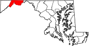
U.S. Highways Interstate Highways Categories:- State highways in Maryland
- Roads in Allegany County, Maryland


Wikimedia Foundation. 2010.