- Maryland Route 936
-
Maryland Route 936
Route information Maintained by MDSHA Length: 5.19 mi[1] (8.35 km) Major junctions South end: Church Street in Midland North end: 


 US 40 Alt. / MD 36 in Frostburg
Location Counties: Allegany Highway system Maryland highway system
Interstate • US • State • Minor • Former • Turnpikes←  MD 935
MD 937  →
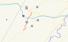
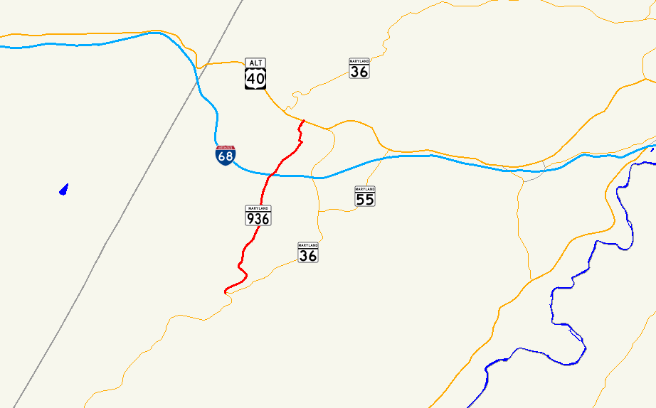
→Maryland Route 936 (MD 936) is a state highway in the U.S. state of Maryland. Known for most of its length as Upper Georges Creek Road, the state highway runs 5.04 miles (8.11 km) from Church Street in Midland north to U.S. Route 40 Alternate (US 40 Alternate) and MD 36 in Frostburg. MD 936 is the old alignment of MD 36 between Midland and Frostburg in the upper Georges Creek Valley of western Allegany County. The state highway was designated when MD 36 moved to a new alignment between the two communities in the early 1970s.
Contents
Route description
MD 936 begins at the intersection of Broadway Street and Church Street in the town of Midland. The state highway is connected to MD 36 (Main Street) by Church Street. MD 936 heads north as two-lane Upper Georges Creek Road paralleling Georges Creek and the Georges Creek Railway. The state highway passes through the small communities of Ocean, Klondike, Woodland, and Borden Shaft, where the railway reaches its northern terminus. MD 936 passes under Interstate 68 (I-68) without access, then enters a residential area. In the community of Grahamtown, the state highway passes through a very sharp S-curve. MD 936 veers to the northwest and enters the city of Frostburg at Green Street, where the highway becomes Grant Street. The state highway veers back north as it ascends a hill through a densely-populated residential area to its northern terminus at US 40 Alternate and MD 36 (Main Street).[1][2]
History
MD 936 is the old alignment of MD 36 between Midland and Frostburg.[3] The highway was paved from Frostburg to Borden Shaft by 1910.[4] The highway from Borden Shaft to Midland was constructed as a state-aid road by 1915.[5] MD 936 was assigned to its present course shortly after MD 36 moved to its new alignment east of MD 936 from Midland to Frostburg in 1972. MD 36 replaced the portion of MD 55 from Midland to Vale Summit. A new highway was constructed for MD 36 from Vale Summit to the eastern end of Frostburg, including the interchange with I-68.[6] MD 936 originally included Broadway Street west from its current southern terminus in Midland. Responsibility for that 0.15-mile (0.24 km) portion of Broadway Street was returned to the town of Midland in 1999.[7]
Junction list
The entire route is in Allegany County.
Location Mile[1] Destinations Notes Midland 0.00 Broadway Street west / Church Street to MD 36Southern terminus Klondike 0.97 Klondike Road west – Woodland Former MD 655 Frostburg 5.04
US 40 Alt. / MD 36 (Main Street) – Cumberland, Mount SavageNorthern terminus 1.000 mi = 1.609 km; 1.000 km = 0.621 mi References
- ^ a b c "Highway Location Reference: Allegany County" (PDF). Maryland State Highway Administration. 2009. http://www.marylandroads.com/Location/2009_ALLEGANY.pdf. Retrieved 2010-11-05.
- ^ Google, Inc. Google Maps – Maryland Route 936 (Map). Cartography by Google, Inc. http://maps.google.com/maps?f=d&source=s_d&saddr=Broadway+St%2FUpper+Georges+Creek+Rd+SW&daddr=S+Grant+St&hl=en&geocode=FTocXAIdOldL-w%3BFaYTXQId1MFL-w&mra=ls&sll=39.649042,-78.922278&sspn=0.001896,0.004823&ie=UTF8&t=h&z=12. Retrieved 2010-11-05.
- ^ Maryland State Roads Commission. General Highway Map: State of Maryland (Map) (1939 ed.).
- ^ Maryland Geological Survey. Map of Maryland (Map) (1910 ed.).
- ^ Report of the State Roads Commission of Maryland. 1912-1915. Baltimore: Maryland State Roads Commission. May 1915. p. 122. http://www.archive.org/details/annualreportsofs1912mary. Retrieved 2010-11-05.
- ^ Maryland State Highway Administration. Maryland: Official Highway Map (Map) (1972 ed.).
- ^ "Highway Location Reference: Allegany County" (PDF). Maryland State Highway Administration. 1999. http://www.marylandroads.com/Location/1999_ALLEGANY.pdf. Retrieved 2010-11-08.
External links
Roads in Allegany County, Maryland State highways 
U.S. Highways Interstate Highways Categories:- State highways in Maryland
- Roads in Allegany County, Maryland


Wikimedia Foundation. 2010.