- Maryland Route 53
-
Maryland Route 53
Winchester Road 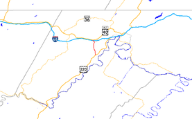
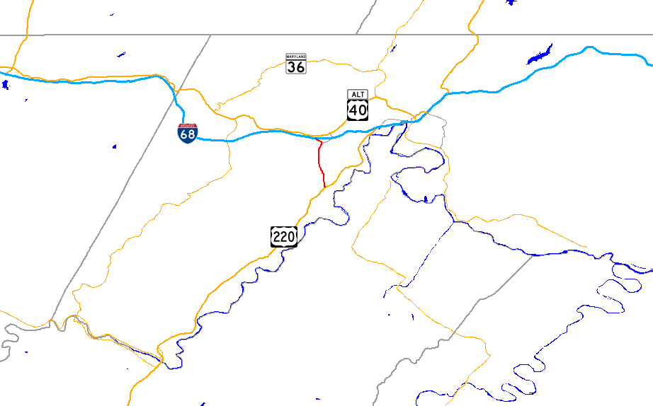
Maryland Route 53 highlighted in redRoute information Maintained by MDSHA Length: 3.33 mi[1] (5.36 km) Major junctions South end:  US 220 in Cresaptown
 I-68 / US 40 in La Vale
North end: 
US 40 Alt. in La ValeLocation Counties: Allegany Highway system Maryland highway system
Interstate • US • State • Minor • Former • Turnpikes←  MD 52
MD 52MD 54  →
→Maryland Route 53 (MD 53) is a state highway in the U.S. state of Maryland. Known as Winchester Road, the state highway runs 3.33 miles (5.36 km) from U.S. Route 220 (US 220) in Cresaptown north to US 40 Alternate in La Vale. MD 53 is part of US 220 Truck, which provides access from Interstate 68 (I-68) west of La Vale to US 220 south for trucks due to a truck prohibition on the eastbound exit ramp for I-68's interchange with US 220.[2] The state highway is also a part of the National Highway System from US 220 to I-68.[3] MD 53 is the northernmost part of the Winchester Road, a colonial era road between Cumberland and Winchester, Virginia. The modern MD 53 was constructed in the mid 1920s and updated in the 1950s.
Contents
Route description
MD 53 begins at an intersection with US 220 (McMullen Highway) in Cresaptown. Winchester Road continues south as a county-maintained highway toward Pinto. MD 53 heads north as a one-way street headed southbound. The state highway becomes two-way at its intersection with Brant Road, which joins the one-way street southbound. MD 53 receives northbound traffic from US 220 via MD 636 (Warrior Drive). Southbound traffic approaching the intersection of MD 53 and MD 636 may use either state highway to access both directions of US 220.[1][4]
MD 53 continues north from MD 636 as a two-lane road that crosses Warrior Run. MD 53 continues north along the western flank of Haystack Mountain, crossing Winchester Run a few times and intersecting both ends of MD 951 (Vine Street), the old alignment of MD 53. The state highway expands to a four-lane divided highway as it passes to the west of Country Club Mall. After an intersection with MD 658 (Vocke Road), MD 53 turns northwest and passes under I-68 (National Freeway), with the only direct access an entrance to eastbound I-68. The state highway then meets its northern terminus at an intersection with US 40 Alternate in La Vale. Access to westbound I-68 is provided a short distance to the east on US 40 Alternate.[1][4]
History
The Winchester Road was first laid out in the 18th century as the route from Cumberland to Winchester, Virginia.[5] The route headed south from near the present intersection of US 40 Alternate and MD 53 to Cresaptown, continued south to a crossing of the Potomac River at Pinto, crossed Knobly Mountain to reach the path of West Virginia Route 28, which it followed to Romney, then followed the path of US 50 east to Winchester.[5][6] Winchester Road south of Cresaptown was never a state highway, but it was upgraded as a military access road to the United States Army's Allegany Ordnance Plant (now the Allegany Ballistics Laboratory) in West Virginia on the opposite side of the Potomac River from Pinto during World War II.[7] The county highway remained the primary access point to the laboratory from Maryland until the construction of MD 956 in 1967.[8][9]
The modern MD 53 was constructed between 1924 and 1926.[10][11][12] MD 53 was rebuilt between 1953 and 1956, bypassing the alignment that is now MD 951.[8][10][13][14] It is not clear when the southernmost portion of MD 53 became one-way southbound. MD 53 was expanded to a divided highway from just south of MD 658 north to US 40 Alternate in 1972 in conjunction with the construction of I-68 through La Vale.[15]
Junction list
The entire route is in Allegany County.
Location Mile
[1]Destinations Notes Cresaptown 0.00 US 220 (McMullen Highway) – Cumberland, McCooleSouthern terminus; southern end of one-way street southbound 0.09 Brant Road Northern end of one-way street southbound; southbound entrance only 0.21  MD 636 east (Warrior Drive)
Northbound traffic from US 220 joins from MD 636; MD 636 is unsigned La Vale 2.70  MD 658 north (Vocke Road) – La Vale
US 220 Truck joins southbound from MD 658 3.14 I-68 east (National Freeway) – Cumberland, HancockEntrance to I-68 east only 3.33
US 40 Alt. (National Pike) – La Vale, FrostburgNorthern terminus 1.000 mi = 1.609 km; 1.000 km = 0.621 mi References
- ^ a b c d "Highway Location Reference: Allegany County" (PDF). Maryland State Highway Administration. 2009. http://www.marylandroads.com/Location/2009_ALLEGANY.pdf. Retrieved 2010-11-09.
- ^ "Maryland Route Restrictions" (PDF). Maryland State Highway Administration. 2010-02-04. http://apps.roads.maryland.gov/OOTS/routere1.pdf. Retrieved 2010-02-22.
- ^ Federal Highway Administration (August 2003) (PDF). National Highway System: Cumberland, MD-PA-WV (Map). http://www.fhwa.dot.gov/planning/nhs/maps/md/cumberland_md.pdf. Retrieved 2010-02-22.
- ^ a b Google, Inc. Google Maps – Maryland Route 53 (Map). Cartography by Google, Inc. http://maps.google.com/maps?f=d&source=s_d&saddr=md-53+and+us+40+alt+la+vale,+md&daddr=us+220+and+md-53+cresaptown,+md&hl=en&geocode=FWTPXAIdHOpM-ymNAqrAJZDKiTEPSQoX7-u45g%3BFY4kXAIdYxdN-ykT0NU5TIXKiTEzzWnCtSN0QQ&mra=ls&sll=39.636927,-78.840938&sspn=0.01517,0.038581&ie=UTF8&t=k&z=13. Retrieved 2010-02-23.
- ^ a b Bruce, Robert (1916). The Old National Road. Washington, D.C.: National Highways Association. http://www.rootsweb.ancestry.com/~mdallegh/nationa2.htm. Retrieved 2010-02-22.
- ^ United States Geological Survey. Frostburg, MD quadrangle (Map). 1:48,000. 15 Minute Series (Topographic) (1898 ed.). http://historical.mytopo.com/quad.cfm?quadname=Frostburg&state=MD&series=15. Retrieved 2010-02-22.
- ^ Report of the State Roads Commission of Maryland. 1941-1942. Baltimore: Maryland State Roads Commission. 1943-03-15. p. 99. http://www.archive.org/details/reportofstateroa1941mary. Retrieved 2010-11-09.
- ^ a b United States Geological Survey. Frostburg, MD quadrangle (Map). 1:48,000. 15 Minute Series (Topographic) (1950 ed.). http://historical.mytopo.com/quad.cfm?quadname=Frostburg&state=MD&series=15. Retrieved 2010-03-08.
- ^ Maryland State Roads Commission. Maryland: Official Highway Map (Map) (1967 ed.).
- ^ a b "NBI Structure Number: 100000010051010". National Bridge Inventory. http://nationalbridges.com/nbi_record.php?StateCode=24&struct=100000010051010. Retrieved 2010-11-09.
- ^ Report of the State Roads Commission of Maryland. 1924-1926. Baltimore: Maryland State Roads Commission. January 1927. p. 54. http://www.archive.org/details/annualreportsofs1924mary. Retrieved 2010-02-22.
- ^ Maryland Geological Survey. Map of Maryland: Showing State Road System and State Aid Roads (Map) (1927 ed.).
- ^ Report of the State Roads Commission of Maryland. 1953-1954. Baltimore: Maryland State Roads Commission. 1954-11-12. p. 204. http://www.archive.org/details/reportofstateroa1953mary. Retrieved 2010-02-22.
- ^ Report of the State Roads Commission of Maryland. 1955-1956. Baltimore: Maryland State Roads Commission. 1956-11-02. p. 191. http://www.archive.org/details/reportofstateroa1955mary. Retrieved 2010-02-24.
- ^ Maryland State Highway Administration. Maryland: Official Highway Map (Map) (1972 ed.).
External links
Roads in Allegany County, Maryland State highways 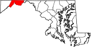
U.S. Highways Interstate Highways Categories:- State highways in Maryland
- Roads in Allegany County, Maryland


Wikimedia Foundation. 2010.