- Maryland Route 657
-
Maryland Route 657
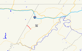
Maryland Route 657 highlighted in redRoute information Maintained by MDSHA and Town of Lonaconing Length: 1.82 mi[1] (2.93 km) Major junctions South end:  MD 36 in Lonaconing
North end: Avilton–Lonaconing Road at the Garrett County line Location Counties: Allegany Highway system Maryland highway system
Interstate • US • State • Minor • Former • Turnpikes←  MD 656
MD 658  →
→Maryland Route 657 (MD 657) is a state highway in the U.S. state of Maryland. The state highway runs 1.82 miles (2.93 km) from MD 36 in Lonaconing north to the Garrett County line, where it continues north as Avilton–Lonaconing Road. MD 657 was designated in 1939 and reconstructed in 2010.
Contents
Route description
MD 657 begins at MD 36 (Main Street) within the Lonaconing Historic District. The state highway heads northwest as Douglas Avenue, a two-lane road with a speed limit of 15 miles per hour (24 km/h) maintained by the town of Lonaconing. After passing Old Beechwood Road, MD 657 leaves the town of Lonaconing, becoming state-maintained with a new name, Skids Hill Road. The roadway narrows to 15 feet (4.6 m) and the speed limit increases to 25 miles per hour (40 km/h) as the state highway climbs toward Big Savage Mountain high above Koontz Creek. At the Garrett County line, MD 657 ends and continues north as Avilton–Lonaconing Road toward the top of the ridge.[1][2]
History
Skids Hill Road was improved as a county highway by the Maryland State Roads Commission in 1934.[3] MD 657 was designated when that county highway was brought into the state highway system in 1939.[4] In March 2010, a 50-foot (15 m) section of the state highway was damaged by a torrent of water released from an abandoned mine following several days of rainfall, requiring an emergency repair project that reduced the roadway's width at the site from 15 feet (4.6 m) to 13.5 feet (4.1 m).[5] MD 657 had already been scheduled to be reconstructed from Old Beechwood Road to the Garrett County line with retaining walls and a wider roadway, a project that began in April 2010 and was expected to be completed in the autumn.[6]
Junction list
The entire route is in Lonaconing in Allegany County.
Mile[1] Destinations Notes 0.00 MD 36 (Main Street) – Westernport, FrostburgSouthern terminus 1.82 Avilton–Lonaconing Road north Northern terminus; Garrett County line 1.000 mi = 1.609 km; 1.000 km = 0.621 mi References
- ^ a b c "Highway Location Reference: Allegany County" (PDF). Maryland State Highway Administration. 2009. http://www.marylandroads.com/Location/2009_ALLEGANY.pdf. Retrieved 2010-11-04.
- ^ Google, Inc. Google Maps – Maryland Route 657 (Map). Cartography by Google, Inc. http://maps.google.com/maps?f=d&source=s_d&saddr=md-36+and+md-657+lonaconing,+md&daddr=md-657+and+avilton-lonaconing+road+lonaconing,+md&hl=en&geocode=FR-9WwIdONxK-ylVbkB55JjKiTEBTg1dQhsV_Q%3BFRcbXAIdz3hK-ymrKi4JZZjKiTGQ9Z-hiQ5AEA&mra=ls&sll=39.577247,-78.976078&sspn=0.030365,0.077162&ie=UTF8&ll=39.578636,-78.992729&spn=0.030365,0.077162&t=h&z=14. Retrieved 2010-03-04.
- ^ Report of the State Roads Commission of Maryland. 1931-1934. Baltimore: Maryland State Roads Commission. 1934-12-28. p. 74. http://www.archive.org/details/reportofstateroa1931mary. Retrieved 2010-11-04.
- ^ Maryland State Roads Commission. General Highway Map: State of Maryland (Map) (1939 ed.).
- ^ Alderton, Jeffrey (2010-03-15). "Floodwaters continue to pour from abandoned mine shaft". Cumberland Times–News (Cumberland, MD: Community Newspaper Holdings). http://times-news.com/local/x1745495274/Floodwaters-continue-to-pour-from-abandoned-mine-shaft. Retrieved 2010-11-04.
- ^ "MD 657 Roadway Widening Project Between Old Beechwood and Garrett County Line". Maryland State Highway Administration. 2010-03-31. http://www.sha.maryland.gov/pages/DistrictNews.aspx?did=d6&id=19. Retrieved 2010-11-04.
External links
Roads in Allegany County, Maryland State highways 
U.S. Highways Interstate Highways Categories:- State highways in Maryland
- Roads in Allegany County, Maryland


Wikimedia Foundation. 2010.