- Maryland Route 61
-
This article is about the current Maryland Route 61. For the former highway, see Maryland Route 61 (former).
Maryland Route 61
Canal Parkway 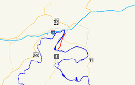
Route information Maintained by MDSHA Length: 1.94 mi[1] (3.12 km) Major junctions South end:  WV 28 in Wiley Ford, WV
North end:  MD 51 in Cumberland
Location Counties: Allegany Highway system Maryland highway system
Interstate • US • State • Minor • Former • Turnpikes←  MD 60
MD 60MD 62  →
→Maryland Route 61 (MD 61) is an unsigned state highway in the U.S. state of Maryland. Known as Canal Parkway, the state highway begins at the West Virginia state line at the Potomac River opposite Wiley Ford, where the highway continues south as West Virginia Route 28 (WV 28). The state highway runs 1.94 miles (3.12 km) north as an automobile parkway to MD 51 within the city of Cumberland. MD 61 provides a connection between downtown Cumberland and the South Cumberland neighborhood and with Greater Cumberland Regional Airport, which is located in Mineral County, West Virginia.
Canal Parkway was constructed as part of a broad group of projects to revitalize the Potomac River waterfront of Cumberland, centered around the historical Chesapeake and Ohio Canal (C&O Canal). The parkway was constructed both as a scenic highway and to improve access to South Cumberland and the airport, which were often cut off from the rest of Cumberland by flooding or traffic jams at the sole connecting point, a railroad underpass on Virginia Avenue. New bridges over the Potomac River and the C&O Canal were built in 1992 and 1997, while the portion of Canal Parkway from the canal crossing toward downtown Cumberland was constructed between 1999 and 2001.
Contents
Route description
MD 61 begins at the West Virginia state line on a bridge across the Potomac River between Wiley Ford and the southern edge of the city of Cumberland. The roadway continues south as WV 28 through Wiley Ford toward Greater Cumberland Regional Airport. MD 61 heads north as a two-lane highway, crossing the C&O Canal and its towpath on a Warren truss bridge. The state highway gains a median and intersects River Avenue, part of the old connection from Cumberland to Wiley Ford that serves the South Cumberland neighborhood. No trucks are allowed on MD 61 north of River Avenue. MD 61 continues north between the C&O Canal to the west and an industrial area to the east, both of which are shielded from view by trees and walls. Beyond Elder Street, the state highway reduces to a two-lane road without a median.[1][2]
As the parkway is approached by CSX's Cumberland Terminal Subdivision west of the Cumberland rail yard, the parkway ceases to be shielded by trees. MD 61 rises onto a retaining wall above the level of the C&O Canal to the west and on level with the railroad that begins to closely parallel the state highway to the east. The state highway's elevation allows views of the Potomac River and Knobly Mountain to the west but discourage views of the adjacent C&O Canal and MD 51 (Industrial Parkway), which parallels the east side of the railroad. MD 61 descends from the retaining wall to cross a rail spur from the Cumberland Terminal Subdivision that heads north to Canal Place. The two directions of the state highway split for a partial interchange with MD 51, with the northbound lane passing under MD 51's overpass of the railroad. The northbound lane of MD 61 has a right-in/right-out interchange with Wineow Street before merging with westbound MD 51 a short distance south of downtown Cumberland.[1][2]
History
Wiley Ford is named for a shallow spot in the Potomac River just east of the present bridge over the river.[3] The first bridge at Wiley Ford was constructed around 1908; a replacement bridge was built in the late 1950s.[4][5] Traffic heading to Wiley Ford from downtown Cumberland travelled Virginia Avenue south from Oldtown Road, the old alignment of MD 51, then followed River Avenue southwest to its present intersection with Canal Parkway, then south across the river along Ford Avenue, which followed the same alignment as MD 61 today.[6] In addition to the route suffering from the standard problems of travelling through city streets, Virginia Avenue passed under the Baltimore & Ohio Railroad tracks via a low, narrow underpass that was vulnerable to flooding and, due to its location immediately south of Virginia Avenue's intersections with MD 51, was the frequent site of traffic jams. A problem at the underpass isolated South Cumberland south of the tracks from the rest of the city and required a lengthy detour through West Virginia. The same problems also hindered access to Greater Cumberland Regional Airport from the city.[7]
Canal Parkway was constructed as part of a broad group of projects to revitalize the Potomac River waterfront south of downtown Cumberland starting in 1989.[7] These projects included:
- The rehabilitation of the C&O Canal, including its re-watering, through the Cumberland portion of the Chesapeake and Ohio Canal National Historical Park by the U.S. Army Corps of Engineers.[8]
- Restoration of historic Western Maryland Railway properties, which included restoration of the former Western Maryland Railway Station and establishment of the Western Maryland Scenic Railroad, a heritage railroad.[9]
- The construction of new bridges across the Potomac River and C&O Canal and an automobile parkway along a portion of the canal by the Maryland State Highway Administration to serve as a scenic highway and to improve access to Greater Cumberland Regional Airport.[7][10][11]
- The construction of Canal Place by the National Park Service to tie together these and other historical properties, including Fort Cumberland and the Downtown Cumberland Historic District.[11]
The first section of Canal Parkway to be built was the reconstruction of Ford Avenue from the West Virginia state line to River Avenue. A new bridge over the Potomac River was completed in 1992.[12] A new bridge over the C&O Canal was completed in 1997, eliminating an at-grade crossing of the highway and the C&O Canal towpath.[13] Construction of Canal Parkway from River Avenue to MD 51 was underway by 1999 and completed in 2001, at which time the highway received the unsigned MD 61 designation.[14][15]
MD 61 originally had two auxiliary routes:
- MD 61A was the designation for an unnamed 0.14-mile (0.23 km) connector west from the intersection of MD 61 and River Avenue to serve properties between the highway and the C&O Canal.[15][16]
- MD 61B was the designation for a 0.08-mile (0.13 km) section of River Avenue immediately east of its intersection with MD 61.[15][17]
Both auxiliary routes were transferred to municipal maintenance in 2005.[18]
Junction list
The entire route is in Cumberland in Allegany County.
Mile[1] Destinations Notes 0.00 WV 28 south – Wiley Ford, Greater Cumberland Regional AirportSouthern terminus; West Virginia state line at Potomac River 0.35 River Avenue Former MD 61B 1.94 MD 51 west (Industrial Boulevard) – Downtown CumberlandNorthern terminus; eastbound exit from and westbound entrance to MD 51 1.000 mi = 1.609 km; 1.000 km = 0.621 mi References
- ^ a b c d "Highway Location Reference: Allegany County" (PDF). Maryland State Highway Administration. 2009. http://www.marylandroads.com/Location/2009_ALLEGANY.pdf. Retrieved 2010-11-07.
- ^ a b Google, Inc. Google Maps – Maryland Route 61 (Map). Cartography by Google, Inc. http://maps.google.com/maps?f=d&source=s_d&saddr=MD-61+N%2FCanal+Pkwy&daddr=Canal+Pkwy%2FS+Wineow+St&geocode=FYaTXAIdCgJO-w%3BFZvxXAIdDzBO-w&hl=en&mra=ls&sll=39.63355,-78.76786&sspn=0.030341,0.077162&ie=UTF8&t=h&z=14. Retrieved 2010-11-07.
- ^ United States Geological Survey. Frostburg quadrangle (Map). 1:48,000. 15 Minute Series (Topographic) (1898 ed.). http://historical.mytopo.com/quad.cfm?quadname=Frostburg&state=MD&series=15. Retrieved 2010-11-08.
- ^ "For Wiley's Ford Bridge". The Baltimore Sun (Baltimore: Tribune Company): p. 5. 1908-01-13.
- ^ "Bridge Plan Is Protested". The Baltimore Sun (Baltimore: Tribune Company): p. 13. 1957-06-20.
- ^ City of Cumberland, Maryland (1938). Street map of Cumberland (Map). http://www.ci.cumberland.md.us/new_site/app/webroot/files/file/engineering/cumberland_1938.pdf. Retrieved 2010-11-08.
- ^ a b c "Canal Parkway, from Wiley Ford Bridge to MD 51". Context Sensitive Solutions. 2005. http://www.contextsensitivesolutions.org/content/case_studies/mdsha_canal/. Retrieved 2008-09-01.
- ^ "Chesapeake and Ohio Canal Rewatering Project Cumberland, Maryland". U.S. Army Corps of Engineers. http://www.nab.usace.army.mil/projects/Maryland/co_canal.htm. Retrieved 2010-11-08.
- ^ "Scenic Railroad Prospers In Western Maryland; Rocky Gap Lodge Boosts Area's Tourist Business". The Baltimore Sun (Baltimore: Tribune Company): p. 12B. 1998-07-26.
- ^ Loverro, Thom (1991-02-17). "Cumberland Studies Plans For Road, Park Along C&O Canal". The Baltimore Sun (Baltimore: Tribune Company): p. 8B.
- ^ a b "Western Maryland Briefs". The Baltimore Sun (Baltimore: Tribune Company): p. 11B. 1994-03-13.
- ^ "NBI Structure Number: 100000010065010". National Bridge Inventory. http://nationalbridges.com/nbi_record.php?StateCode=24&struct=100000010065010. Retrieved 2010-11-08.
- ^ "NBI Structure Number: 100000010172010". National Bridge Inventory. http://nationalbridges.com/nbi_record.php?StateCode=24&struct=100000010172010. Retrieved 2010-11-08.
- ^ Maryland State Highway Administration. Maryland: Official Highway Map (Map) (1999-2000 ed.).
- ^ a b c "Highway Location Reference: Allegany County" (PDF). Maryland State Highway Administration. 2001. http://www.marylandroads.com/Location/2001_ALLEGANY.pdf. Retrieved 2010-11-07.
- ^ Google, Inc. Google Maps – Maryland Route 61A (Map). Cartography by Google, Inc. http://maps.google.com/maps?f=d&source=s_d&saddr=Unknown+road&daddr=Unknown+road&geocode=FbafXAId4ANO-w%3BFX6lXAIdWgdO-w&hl=en&mra=ls&sll=39.625276,-78.772386&sspn=0.001897,0.004823&ie=UTF8&ll=39.625379,-78.772836&spn=0.001897,0.004823&t=h&z=18. Retrieved 2010-11-07.
- ^ Google, Inc. Google Maps – Maryland Route 61B (Map). Cartography by Google, Inc. http://maps.google.com/maps?f=d&source=s_d&saddr=Canal+Pkwy&daddr=River+Ave&geocode=FX6lXAIdvgdO-w%3BFcSlXAIdaA1O-w&hl=en&mra=ls&sll=39.626162,-78.770634&sspn=0.000948,0.002411&ie=UTF8&ll=39.626125,-78.771565&spn=0.000948,0.002411&t=h&z=19. Retrieved 2010-11-07.
- ^ "Highway Location Reference: Allegany County" (PDF). Maryland State Highway Administration. 2005. http://www.marylandroads.com/Location/2005_ALLEGANY.pdf. Retrieved 2010-11-07.
External links
Roads in Allegany County, Maryland State highways 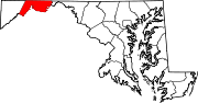
U.S. Highways Interstate Highways Categories:- State highways in Maryland
- Roads in Allegany County, Maryland


Wikimedia Foundation. 2010.