- Greater Cumberland Regional Airport
-
Coordinates: 39°36′56″N 078°45′39″W / 39.61556°N 78.76083°W
Greater Cumberland Regional Airport 
IATA: CBE – ICAO: KCBE – FAA LID: CBE Summary Airport type Public Operator Potomac Highlands Airport Authority Serves Cumberland, Maryland Location Wiley Ford, West Virginia Elevation AMSL 775 ft / 236 m Website Runways Direction Length Surface ft m 5/23 5,048 1,539 Asphalt 11/29 2,442 744 Asphalt Statistics (2006) Aircraft operations 14,300 Based aircraft 69 Source: Federal Aviation Administration[1] Greater Cumberland Regional Airport (IATA: CBE, ICAO: KCBE, FAA LID: CBE) is a public airport located in the town of Wiley Ford (population 1,095) in Mineral County, West Virginia. It is two miles (3 km) south of the larger city of Cumberland (population 21,518) in Allegany County, Maryland. Although the airport is located in the Potomac Highlands of West Virginia, the FAA lists this as a Maryland airport.[1]
The airport has not had commercial service from a major airline since US Airways Express carrier Air Midwest left in September 2001. But from 2001 the airport was served by a spin off of the former Pan Am Airways group until May 2003 when different factors caused Cumberland Airport to lose final air service
Located on the second level of the airport terminal is the Cohongaronta Gallery (Cohongaronta being a Shawnee name for the Potomac River). It contains an array of historical displays pertaining to the history of the Potomac Highlands area. The centerpiece of the gallery is a 40% scaled replica of the Wright Brothers 1903 Wright Flyer that set the stage for aerial transportation. A 70-foot-long (21 m) time line highlights pertinent dates and events for the Potomac Highlands region. The gallery is open to the public during terminal business hours.
Contents
Facilities and aircraft
Greater Cumberland Regional Airport covers an area of 314 acres (127 ha) which contains two asphalt paved runways: 5/23 measuring 5,048 x 150 ft (1,539 x 46 m) and 11/29 measuring 2,442 x 150 ft (744 x 46 m).[1]
For the 12-month period ending August 2, 2006, the airport had 14,300 aircraft operations, an average of 39 per day: 98% general aviation and 2% military. There are 69 aircraft based at this airport: 81% single engine, 7% gliders, 6% multi-engine, 3% jet aircraft and 3% helicopters.[1]
Racing
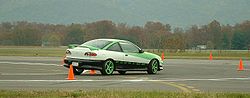 Pumpkin Carve Autocross, 25 October 2003
The Cumberland Greater Regional Airport was used for a 1.6-mile (2.6 km) airport course run in Wiley Ford, West Virginia (just south of Cumberland, Maryland) in the 1950s and 1960s.
Currently National Road Autosport holds Autocross events at the airport on a monthly basis.[2]
References
- ^ a b c d FAA Airport Master Record for CBE (Form 5010 PDF), effective 2007-07-05
- ^ Autocross Schedule
External links
- Greater Cumberland Regional Airport (official web site)
- Greater Cumberland Regional Airport at West Virginia Airport Directory
- Resources for this airport:
- AirNav airport information for KCBE
- ASN accident history for CBE
- FlightAware airport information and live flight tracker
- NOAA/NWS latest weather observations
- SkyVector aeronautical chart, Terminal Procedures for KCBE
City of Cumberland Subject areas Attractions • Climate • Demographics • Festivals/Events • Education • Geography • History • Media • People • Sports • Major employers • Transportation
Top subjects Allegany Arts Council • Allegany College of Maryland • Allegany Community Symphony Orchestra • Allegany Magazine • Chesapeake and Ohio Canal National Historical Park • Constitution Park • Cumberland Times-News • Cumberland Theatre • Greater Cumberland Regional Airport • Mountain Discoveries • Railfest • Western Maryland Scenic RailroadNeighborhoods Bowling Green • Downtown • East Side • Little Egypt • Haystack Mountain • North End • Shriver Ridge • South Cumberland • West Side • Wills MountainCategories:- Transportation in Cumberland, MD-WV-PA
- Businesses located in Cumberland, MD-WV-PA
- Airports in West Virginia
- Buildings and structures in Mineral County, West Virginia
- Motorsport venues in West Virginia
- Transportation in Mineral County, West Virginia

Wikimedia Foundation. 2010.