- Spruce Knob
Geobox|Summit
name = Spruce Knob
native_name =
other_name =
other_name1 =
topo_maker = USGS
topo_
range = Allegheny Mountains
parent = Spruce Mountain
category =
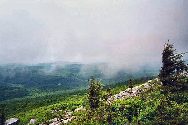
image_caption = The west side of the summit at Spruce Knob.
etymology_type =
etymology =
country = United States
country_
state = West Virginia
state_
region_type = County
region = Pendleton
district_type =
district =
district1 =
district2 =
city =
city1 =
location =
lat_d = 38
lat_m = 41
lat_s = 59
lat_NS = N
long_d = 79
long_m = 31
long_s = 58
long_EW = W
elevation_imperial = 4863
elevation_round = 1
prominence_imperial = 2783
prominence_note = [cite web|url=http://www.peaklist.org/USlists/WV500.html|title=West Virginia Summits|publisher=PeakList.org|accessdate=2008-04-20]
Listing = U.S. state high point
area_unit = acre
area_imperial =
area_round = 1
area_note =
area1_imperial =
area1_type =
length_imperial =
length_orientation =
width_imperial =
width_orientation =
highest =
highest location =
highest_lat_d =
highest_lat_m =
highest_lat_s =
highest_lat_NS =
highest_long_d =
highest_long_m =
highest_long_s =
highest_long_EW =
highest_elevation_imperial =
lowest =
lowest_location =
lowest_lat_d =
lowest_lat_m =
lowest_lat_s =
lowest_lat_NS =
lowest_long_d =
lowest_long_m =
lowest_long_s =
lowest_long_EW =
lowest_elevation_imperial =
biome =
biome_share =
biome1 =
biome1_share =
geology =
geology1 =
plant =
plant1 =
animal =
animal1 =
access = drive-up via 104
established_type =
established =
established_note =
established1_type =
established1 =
established1_note =
owner =USDA Forest Service
management =Monongahela National Forest
management_lat_d =
management_lat_m =
management_lat_s =
management_lat_NS =
management_long_d =
management_long_m =
management_long_s =
management_long_EW =
management_elevation =
visitation =
visitation_year =
free_type = Nearest city
free_label = Nearest city
free = Riverton,West Virginia
free1_type =
free1 =

map_caption = Location of Spruce Knob in West Virginia
map_locator = West Virginia
map_first =
website = [http://www.fs.fed.us/r9/mnf/sp/spruce_knob.html Spruce Knob]Spruce Knob, at convert|4863|ft, is the highest point in the state of
West Virginia , USA, and the summit of Spruce Mountain, the tallest mountain in the Alleghenies.Overview
Its summit has a definite alpine feel, much more so than other mountains of the Southern
Appalachians . The upper few hundred feet of the mountain are covered in a densespruce forest, a relictboreal forest environment similar to forests found in northernNew England andCanada . The summit is accessible via a long gravel road, and is crowned with a stone lookout tower while a mixture of boulder fields, meadows and trees are on the summit as well. A half mile (800 m) long handicap accessible nature trail circles the topmost part of the mountain. There are often high west winds near the summit, and as a result the spruce trees have limbs on only one side, pointing eastward. As is typical of the southern Appalachians, the highest point on a ridge is frequently referred to as a knob or dome. Spruce Knob is the highest point along this ridge better known as theAllegheny Front . The ridge drops steeply to the east with views of the Germany Valley available on clear days, while the view west is of theAllegheny Plateau . Geologically, Spruce Knob is formed on a resistant bed of PennsylvanianPottsville Sandstone .Climate
Spruce Knob's climate can be classified as
humid continental . Summers are cool and often damp, while winters are cold and snowy. Thunderstorms are common in Spring and Summer. The mountain receives 160 + inches of snowfall annually, and for this reason the summit access road is often closed between October and April.Ecology
While spruce is the most common tree species on the summit, the lower altitudes are populated by
oak ,hickory ,birch ,beech andmaple .Bald eagle s,hawk s andperegrine falcon s have been seen on the mountain. Mammals such as Black Bear,White-tailed Deer ,weasel ,porcupine ,skunk andrabbit are also found.Recreation
Spruce Knob is within the
Spruce Knob-Seneca Rocks National Recreation Area , which in turn is part ofMonongahela National Forest . Established in 1965, it is the very firstNational Recreation Area designated by theU.S. Forest Service and consists of over convert|100000|acre.There are over convert|75|mi|km of hiking trails around the mountain and a small convert|25|acre|adj=on lake well stocked with trout on the west side of the mountain. Two campgrounds are also on the mountain with the one nearest the lake being the larger with 43 sites.
Access
Best access is from
Interstate 81 heading west onU.S. Route 33 from Harrisonburg,Virginia for approximately convert|50|mi. Briery Gap Road is convert|2|mi south of Riverton, West Virginia off US 33. Follow for convert|2.5|mi to Forest Road 112 and follow the signs to Spruce Knob. Forest Road 112 is a narrow but well graded unpaved access road and continues for convert|8|mi to the mountain top. Expect winter conditions and possible road closures anytime from mid October to mid April.Photo gallery
ee also
*
Mountain peaks of North America
*Mountain peaks of the United States References
External links
* [http://www.fs.fed.us/r9/mnf/sp/sksrnra.html Monongehela National Forest]
* [http://www.kenharker.com/photos/1998_spruce_knob/ Photos from a visit to Spruce Knob, 1998]


Wikimedia Foundation. 2010.