- Harpers Ferry, West Virginia
:"Harpers Ferry redirects here. For other uses, see
Harpers Ferry (disambiguation) ."Infobox Settlement
official_name = Harpers Ferry, West Virginia
settlement_type =Town
nickname Bold text =
motto dfdsfsert45gv =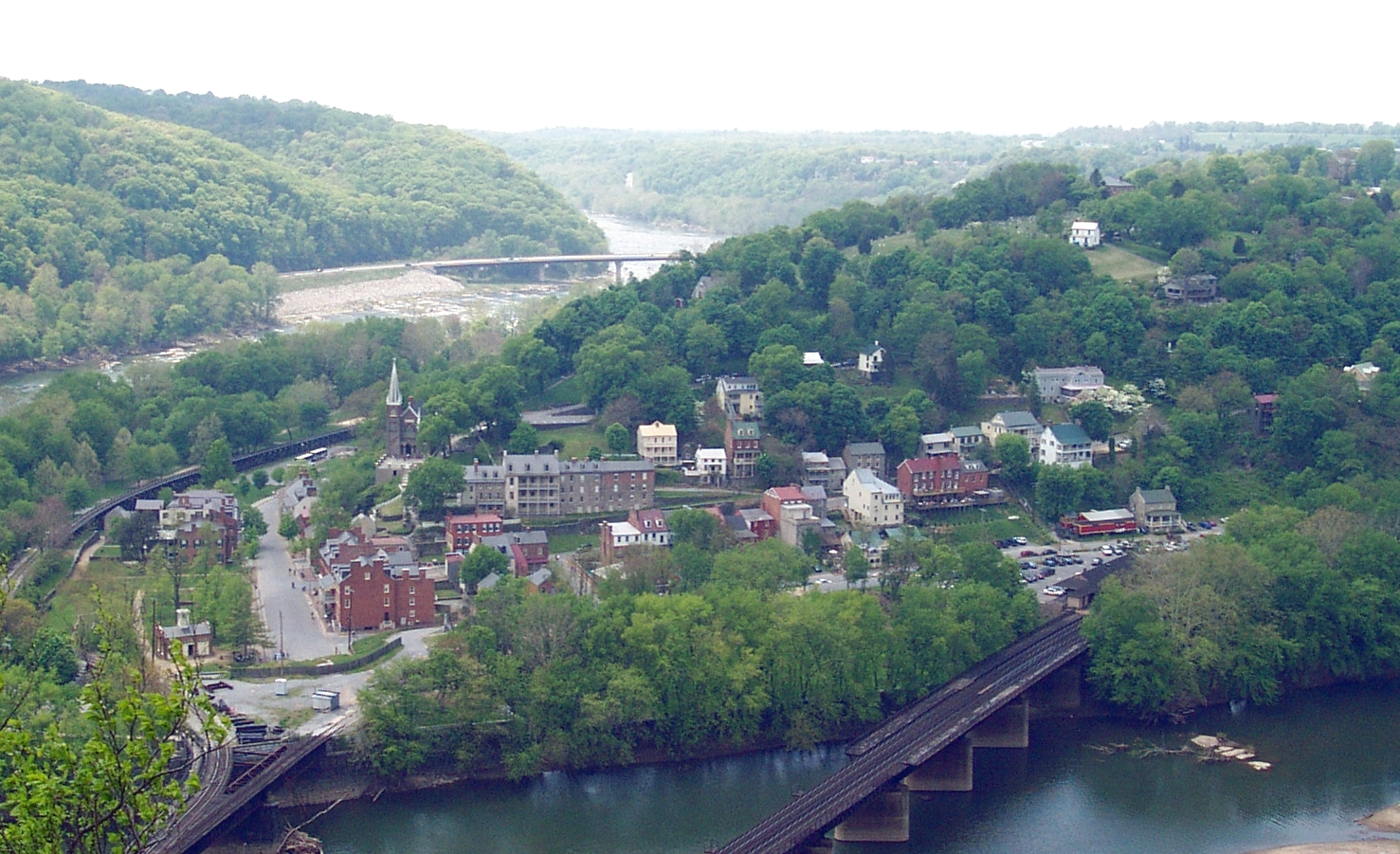
imagesize =
image_caption = Harpers Ferry from Maryland side of Potomac River
image_
mapsize =
map_caption =
mapsize1 =
map_caption1 =subdivision_type = Country
subdivision_name =United States
subdivision_type1 = State
subdivision_name1 =West Virginia
subdivision_type2 = County
subdivision_name2 = Jeffersongovernment_footnotes =
government_type =
leader_title =
leader_name =
leader_title1 =
leader_name1 =
established_title =
established_date =area_footnotes =
area_magnitude =
area_total_km2 = 1.6
area_land_km2 = 1.4
area_water_km2 = 0.2
area_total_sq_mi = 0.6
area_land_sq_mi = 0.6
area_water_sq_mi = 0.1population_as_of = 2000
population_footnotes =
population_total = 307
population_density_km2 = 213.2
population_density_sq_mi = 552.2timezone = Eastern (EST)
utc_offset = -5
timezone_DST = EDT
utc_offset_DST = -4
elevation_footnotes =
elevation_m = 149
elevation_ft = 489
latd = 39 |latm = 19 |lats = 31 |latNS = N
longd = 77 |longm = 44 |longs = 37 |longEW = Wpostal_code_type =
ZIP code
postal_code = 25425
area_code = 304
blank_name = FIPS code
blank_info = 54-35284GR|2
blank1_name = GNIS feature ID
blank1_info = 1560593GR|3
website =
footnotes =Harpers Ferry is a historic town in Jefferson County,
West Virginia . It is situated at theconfluence of the Potomac andShenandoah River s where theU.S. state s ofMaryland ,Virginia , andWest Virginia meet. The town is located on a low lyingflood plain created by the two rivers, it is thus surrounded by higher ground on all sides. Historically, Harpers Ferry is best known for John Brown's raid on the Armory in 1859 and its role in theAmerican Civil War . As of the 2000 census, the town had a population of 307.cite web
title =Harpers Ferry Town Website
work =
publisher =
date =
url =http://www.harpersferrywv.us/
format =
doi =
accessdate =2007-07-19]The lower part of Harpers Ferry is located within
Harpers Ferry National Historical Park . Most of the remainder, which includes the higher, more populated area, is included in the separateHarpers Ferry Historic District . Two otherNational Register of Historic Places properties adjoin the town: theB & O Railroad Potomac River Crossing and St. Peter's Roman Catholic Church.The
Appalachian Trail Conservancy (ATC) headquarters is located in Harpers Ferry and the town is one of only a few that theAppalachian Trail passes directly through.History
Establishment
In 1733, a German immigrant named Peter Stephens (originally "Stephan") established the
ferry at the lowest point where the rivers joined. In 1747, Robert Harper bought the ferry and land surrounding it and renamed it for himself.In 1751, Robert Harper was given a patent on 125 acres (0.5 km²) at the present location of the town. In 1761, Harper established a ferry across the Potomac, making the town a starting point for settlers moving into the
Shenandoah Valley and further west. In 1763, theVirginia General Assembly established the town of "Shenandoah Falls at Mr. Harper's Ferry."On
October 25 ,1783 ,Thomas Jefferson visited Harpers Ferry. He viewed "the passage of the Potomac though the Blue Ridge" from a rock which is now named for him. Jefferson was actually on his way toPhiladelphia and passed through Harpers Ferry with his daughter Patsy. Jefferson called the site "perhaps one of the most stupendous scenes in nature.”George Washington , as president of thePatowmack Company (which was formed to complete river improvements on the Potomac and its tributaries), traveled to Harpers Ferry during the summer of 1785 to determine the need for bypasscanal s. In 1794, Washington's familiarity with the area led him to propose the site for a newUnited States armory andarsenal . Some of Washington's family moved to the area; his great-great nephew, Colonel Lewis Washington, was held hostage during John Brown's raid in 1859.In 1796, the federal government purchased a convert|125|acre|km2|1|sing=on parcel of land from the heirs of Robert Harper and, in 1799, construction began on the United States Armory and Arsenal at Harpers Ferry. [http://www.nps.gov/archive/hafe/armory.htm; Harpers Ferry NHP Armory and Arsenal; accessed 2007-04-05] This was one of only two such facilities in the US, the other being
Springfield, Massachusetts , and between them they produced most of the small arms for the US Army. The town was transformed into an industrial center; Between 1801 and its destruction in 1861 to prevent its capture during the Civil War, the Armory produced more than 600,000 muskets, rifles, and pistols. InventorCaptain John H. Hall pioneered the use of interchangeable parts in firearms manufactured at his Rifle Works at the armory between 1820 and 1840; hisM1819 Hall rifle was the first breech loading weapon adopted by the US Army.This industrialization continued in 1833 when the
Chesapeake & Ohio Canal reached Harpers Ferry linking it withWashington, D.C. A year later, theBaltimore & Ohio Railroad began train service through the town.John Brown's raid
On
October 16 ,1859 , the radicalabolition ist John Brown led a group of 22 men in a raid on the Arsenal. Five of the men were black: three free blacks, one a freed slave, and one a fugitive slave. During this time assisting fugitive slaves was illegal under theDred Scott decision . Brown attacked and captured several buildings; he hoped to use the captured weapons to initiate a slave uprising throughout the South. The first shot mortally wounded Heyward Shepherd [http://www.wvculture.org/history/journal_wvh/wvh56-1.html; An "Ever Present Bone of Contention": The Heyward Shepherd Memorial; accessed 2008-02-24] . Shepherd was a free black man that was a night baggage porter for the B&O Railroad that ran through Harpers Ferry near the armory. The noise from that shot roused Dr. John Starry from his sleep shortly after 1:00 a.m. He walked from his nearby home to investigate the shooting and was confronted by Brown's men. Starry stated that he was a doctor but could do nothing more for Shepherd, and Brown's men allowed him to leave. Instead of going home, Starry went to thelivery and rode to neighboring towns and villages, alerting residents to the raid.When he reached nearby Charles Town, they rang the church bells and aroused the citizens from their sleep. John Brown's men were quickly pinned down by local citizens and militia, and forced to take refuge in the engine house adjacent to the armory.
The Secretary of War asked for the assistance of the Navy Department for a unit of United States Marines, the nearest troops. [ cite book
last =Sullivan
first =David
authorlink =
coauthors =
title =The United States Marine Corps in the Civil War - The First Year
publisher =White Mane Publishing Company, Inc.
date =1997
location =
pages =1 to 27
url =
doi =
id =
isbn = 1-57249-040-3 ] Lieutenant Israel Greene was ordered to take a force of 86 Marines to the town. In need of an officer to lead the expedition, U.S. ArmyColonel Robert E. Lee was found on leave nearby and was assigned as commander along with LieutenantJ. E. B. Stuart as his "aide-de-camp ". The whole contingent arrived by train on October 18, and after negotiation failed, they stormed the fire house and captured most of the raiders, killing a few and suffering a single casualty themselves. Brown was tried fortreason against the state of Virginia, convicted, and hanged in nearby Charles Town. Starry's testimony was integral to his conviction. Following the prosecution (by Andrew Hunter), "John Brown captured the attention of the nation like no other abolitionist or slave owner before or since." The Marines returned to their barracks and Colonel Lee returned to finish his leave. The raid was a catalyst for the Civil War.Civil War
The Civil War was disastrous for Harpers Ferry, which changed hands eight times between 1861 and 1865 [Reynolds, John. "John Brown: Abolitionist." New York: Knopf, 2005 p. 309 ] . When Virginia seceded in April 1861 the US garrison attempted to burn the arsenal and destroy the machinery. Locals saved the equipment, which was later transferred to a more secure location in Richmond. Arms production never returned to Harpers Ferry.
Because of the town's strategic location on the railroad and at the northern end of the
Shenandoah Valley , both Union and Confederate troops moved through Harpers Ferry frequently. The town's garrison of 14,000 Federal troops played a key role in the Confederate invasion of Maryland in September of 1862. GeneralRobert E. Lee did not want to continue on to Pennsylvania without capturing the town, which was on his supply line and would control one of his possible routes of retreat if the invasion did not go well. Dividing his army of approximately 40,000 into four sections, he used the cover of the mountains and sent three columns underStonewall Jackson to surround and capture the town. [http://www.nps.gov/hafe/jackson.htm Harpers Ferry NHP Stonewall Jackson ] ]The
Battle of Harpers Ferry started with light fighting September 13 to capture the Maryland Heights to the northeast while John Walker moved back over the Potomac to capture Loudoun Heights south of town. After an artillery bombardment on September 14 and 15, the Federal garrison surrendered. Lee, because of the delay in capturing Harpers Ferry, and the movement of Federal forces west, was forced to regroup at the town of Sharpsburg, leading two days later to theBattle of Antietam , the bloodiest single day in American military history. Without the distraction of Union forces at Harpers Ferry during the Antietam campaign, the ability of Union forces to turn back the Confederate invasion at Antietam is debatable.Shortly after the end of the Civil War, Harpers Ferry, along with all of both Berkeley and Jefferson Counties, was separated from Virginia and incorporated into West Virginia. The inhabitants of the counties as well as the Virginia legislature protested, but the federal government went ahead anyway, forming the West Virginia "panhandle" of today.
20th Century
On
August 15 ,1906 , theNiagara Movement , led by author and scholarW.E.B. DuBois , held its first meeting on American soil on the campus ofStorer College , now part of Harpers Ferry National Historical Park. The three-day gathering,was held to secure civil rights forAfrican Americans , was later described by DuBois as "one of the greatest meetings that American Negroes ever held." Attendees of the 1906 meeting walked fromStorer College to the nearby farm of the Murphy family, then the site of the historic fort where John Brown's quest to free four million enslaved African Americans reached its bloody climax.In 1944, most of the town became part of the
National Park Service and it is now maintained as theHarpers Ferry National Historical Park . The majority of the existing homes in Harpers Ferry (includingCharmadoah ) are very old, and some of these are registered in theNational Register of Historic Places .In 1950 Harpers Ferry had a population of 822. ["Columbia-Lippincott Gazeteer" p. 760]
Rail transportation
Amtrak , the national passenger rail system, provides service to Harpers Ferry two times a day (once in each direction). It is also served by the MARC commuter rail service, on its Brunswick line. The city's passenger rail station is located at the West Virginia end of the historic railroad bridge across the Potomac River. In addition about forty or fiftyCSX freight trains daily pass through Harpers Ferry and over the bridge spanning the Potomac River.Geography
Harpers Ferry is located at coor dms|39|19|31|N|77|44|37|W|city (39.325398, -77.743599)GR|1.
According to the
United States Census Bureau , the town has a total area of 1.6 km² (0.6 mi²). 1.5 km² (0.6 mi²) of it is land and 0.2 km² (0.1 mi²) of it (9.68%) is water.Some properties are currently threatened by development. [ [ http://www.nps.gov/hafe/parkmgmt/development-threatens-park-experience.htm "Development Threatens Park Experience"] ,National Park Service ]Thomas Jefferson wrote in "Notes on the State of Virginia", published in 1785, thatquotation
"The passage of the Patowmac through the Blue Ridge is perhaps one of the most stupendous scenes in Nature." [ [http://www.nps.gov/archive/hafe/jeffrock.htm "Thomas Jefferson at Harpers Ferry"] , David T. Gilbert,National Park Service ] From most of Harper's Ferry, a fading advertisement fortooth powder painted on the cliff face ofMaryland Heights decades ago is visible. [ [http://books.google.com/books?id=hubQI-Ojsi0C&pg=PA5&lpg=PA5&dq=tooth+advertisement+%22harper's+ferry%22&source=web&ots=-WbIhfvqU1&sig=ikmIiF2ZDzqOGEQmB7eHjfrZgeo&hl=en&sa=X&oi=book_result&resnum=3&ct=result "Harper's Ferry Vignette"] , John Armstrong, page 5 of "The Classic Layout Designs of John Armstrong: A Compilation", Kalmbach Publishing Company, 2001, ISBN 0890244170] ]Demographics
As of the
census GR|2 of 2000, there were 307 people, 153 households, and 89 families residing in the town. Thepopulation density was 211.7/km² (552.2/mi²). There were 189 housing units at an average density of 130.3/km² (339.9/mi²). The racial makeup of the town was 89.90% White, 9.12% African American, 0.33% Native American, and 0.65% from two or more races. 0.65% of the population were Hispanic or Latino of any race.There were 153 households out of which 17.6% had
children under the age of 18 living with them, 45.1% were married couples living together, 11.8% had a female householder with no husband present, and 41.8% were non-families. 36.6% of all households were made up of individuals and 9.8% had someone living alone who was 65 years of age or older. The average household size was 2.01 and the average family size was 2.56.In the town the population was 17.3% under the age of 18, 2.0% from 18 to 24, 28.0% from 25 to 44, 30.9% from 45 to 64, and 21.8% who were 65 years of age or older. The median age was 47 years. For every 100 females there were 90.7 males. For every 100 females age 18 and over, there were 92.4 males.
The median income for a household in the town was $52,344, and the median income for a family was $70,313. Males had a median income of $45,417 versus $22,708 for females. The
per capita income for the town was $29,638. About 3.2% of families and 2.2% of the population were below thepoverty line , including 2.8% of those under the age of eighteen and none of those sixty five or over.John Brown's bell controversy
During a Union Army occupation of Harper's Ferry, a contingent of soldiers from
Marlborough, Massachusetts removed a bell hanging in the Harper's Ferry arsenal firehouse. The Harper's Ferry firehouse had served asJohn Brown's Fort . Several of those from Marlborough were in the fire department in Marlborough, called the "'Torrent' Fire/engine Company", according to the city of Marlborough website. They took the bell back to Marlborough where it has remained ever since. Harper's Ferry has made some attempts over the years to retrieve the bell, none of them successful. [ [http://www.metrowestdailynews.com/news/x2109422348/Kleinkauf-John-Browns-bell-should-be-returned "John Brown's bell should be returned"] , Jim Kleinkauf, MetroWest Daily News, July 23, 2008]ee also
*
John Anthony Copeland, Jr.
*Shields Green
*John Henry Kagi
*Lewis Sheridan Leary References
Maps and satellite imagery
External links
* [http://www.harpersferrywv.net/ HarpersFerryWV.net]
* [http://www.harpersferrywv.us/ Corporation of Harpers Ferry Website]
* [http://www.nps.gov/hafe/home.htm Harpers Ferry National Historical Park]
* [http://historicharpersferry.org/ Harpers Ferry Historic Town Foundation]
* [http://harpersferry.wordpress.com/ Harpers Ferry Foundation blog]
* [http://www.amtrak.com/servlet/ContentServer?pagename=Amtrak/am2Station/Station_Page&code=HFY Amtrak Station Stop, Harpers Ferry]
* [http://eastghost.com/post/59754 Pictures, histories, stories, experiences on eastghost.com]
* [http://cdl.library.cornell.edu/cgi-bin/moa/moa-cgi?notisid=ABP2287-0030&byte=32785855 Capt. John E. P. Daingerfield's account of Harper's Ferry]
*wikitravel|Harpers Ferry
Wikimedia Foundation. 2010.