- Maryland Route 736
-
Maryland Route 736
Route information Maintained by MDSHA Length: 1.27 mi[1] (2.04 km) Major junctions South end: 
 I-68 / US 40 in Frostburg
North end: Park Avenue in Frostburg Location Counties: Allegany Highway system Maryland highway system
Interstate • US • State • Minor • Former • Turnpikes←  MD 735
MD 737  →
→Maryland Route 736 (MD 736) is an unsigned state highway in the U.S. state of Maryland. Known for much of its length as Midlothian Road, the state highway runs 1.27 miles (2.04 km) from Interstate 68 (I-68) north to Park Avenue within Frostburg. MD 736 is the primary access road to Frostburg State University. The former county highway was relocated when its interchange with I-68 was completed in the mid 1970s. The highway was designated MD 736 in 1998.
Contents
Route description
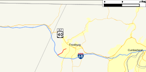
MD 736 begins at Midlothian Road's diamond interchange with I-68 and U.S. Route 40 (National Freeway) on the western edge of Frostburg. Midlothian Road continues southwest as a county highway toward Midlothian. Two-lane MD 736 heads northeast, becoming Braddock Road at Braddock Street, the old alignment of Midlothian Road. MD 736 passes the Appalachian Laboratory of the University of Maryland Center for Environmental Science before reaching University Drive, where the campus of Frostburg State University begins to line the southbound direction of the state highway. MD 736 crosses Sand Spring Run before reaching its northern terminus at an intersection with Park Avenue and Bowery Street. Bowery Street is one-way southbound toward the intersection while Park Avenue headed northwest is one-way westbound away from the intersection.[1][2]
History
Midlothian Road is a long-time link between Frostburg and Midlothian.[3] In the early 1970s, the county highway was relocated around the highway's interchange with I-68, which was completed around 1974.[4] MD 736 was assigned to Midlothian Road and Braddock Road in 1998.[5]
Junction list
The entire route is in Frostburg in Allegany County.
Mile
[1]Destinations Notes 0.00 I-68 / US 40 (National Freeway) / Midlothian Road south – Midlothian, Cumberland, MorgantownSouthern terminus; I-68 Exit 33 1.27 Park Avenue Northern terminus 1.000 mi = 1.609 km; 1.000 km = 0.621 mi References
- ^ a b c "Highway Location Reference: Allegany County" (PDF). Maryland State Highway Administration. 2009. http://www.marylandroads.com/Location/2009_ALLEGANY.pdf. Retrieved 2010-11-02.
- ^ Google, Inc. Google Maps – Maryland Route 736 (Map). Cartography by Google, Inc. http://maps.google.com/maps?f=d&source=s_d&saddr=Braddock+Rd%2FMD-736%2FMidlothian+Rd%2FOld+Legislative+Rd+SW&daddr=Braddock+St&hl=en&geocode=FUDUXAIdM1tL-w%3BFYj_XAIdPKBL-w&mra=ls&sll=39.649831,-78.93018&sspn=0.007583,0.01929&ie=UTF8&t=h&z=15. Retrieved 2010-03-10.
- ^ United States Geological Survey. Frostburg quadrangle (Map). 1:48,000. 15 Minute Series (Topographic) (1898 ed.). http://historical.mytopo.com/quad.cfm?quadname=Frostburg&state=MD&series=15. Retrieved 2010-11-02.
- ^ Maryland State Highway Administration. Maryland: Official Highway Map (Map) (1974 ed.).
- ^ "Traffic Volume Map" (PDF). Maryland State Highway Administration. 1998. http://www.marylandroads.com/Traffic_Volume_Maps/98_Traffic_Volume_Maps.pdf. Retrieved 2010-03-10.
Roads in Allegany County, Maryland State highways 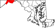
U.S. Highways Interstate Highways Categories:- State highways in Maryland
- Roads in Allegany County, Maryland


Wikimedia Foundation. 2010.