- Maryland Route 956
-
Maryland Route 956 Patriot Parkway 
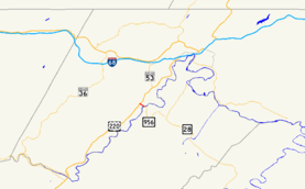
Maryland Route 956 highlighted in redRoute information Maintained by MDSHA Length: 0.53 mi[1] (0.85 km) Major junctions West end:  US 220 in Pinto
East end:  WV 956 in Pinto
Location Counties: Allegany Highway system Maryland highway system
Interstate • US • State • Minor • Former • Turnpikes←  MD 954
MD 963  →
→Maryland Route 956 (MD 956) is a state highway in the U.S. state of Maryland. Known as Patriot Parkway. the state highway runs 0.53 miles (0.85 km) from U.S. Route 220 (US 220) in Pinto east to the West Virginia state line at the Potomac River, where the highway continues as West Virginia Route 956 (WV 956) in Rocket Center. MD 956, which is the highest numbered signed route in the Maryland state highway system, serves as a connector from US 220 to WV 28 south of Cumberland as well as the primary access to the Allegany Ballistics Laboratory. The state highway was constructed in 1967. MD 956 and WV 956 received their common number by 1985.
Contents
Route description
MD 956 begins at an intersection with US 220 (McMullen Highway) in Pinto. The state highway heads east as a two-lane road, crossing CSX's Mountain Subdivision. MD 956 reaches its eastern terminus at its bridge over the Potomac River into West Virginia. The road continues east as WV 956, which provides access to the Allegany Ballistics Laboratory, then crosses Knobly Mountain and meets WV 28 at Short Gap.[1][2]
History
The Winchester Road, of which the northernmost part is now MD 53, crossed the Potomac River at Pinto.[3] A bridge over the river connecting Pinto with the Allegany Ballistics Laboratory remained as late as 1950. The road crossed the military installation and ascended Knobly Mountain, meeting present-day WV 956 just west of WV 28.[4] The bridge was removed at a later date. In 1967, a new highway featuring a crossing of a Potomac River was completed between US 220 and WV 28 to provide better access from Maryland to the government reservation and to WV 28.[5] By 1985, the highway was signed as MD 956 and WV 956.[6] MD 956 was designated Patriot Parkway in 2004.[7]
Junction list
The entire route is in Pinto in Allegany County.
Mile[1] Destinations Notes 0.00  US 220 (McMullen Highway) – Cumberland, McCoole
Western terminus 0.53  WV 956 east – Rocket Center, WV
Eastern terminus 1.000 mi = 1.609 km; 1.000 km = 0.621 mi References
- ^ a b c "Highway Location Reference: Allegany County" (PDF). Maryland State Highway Administration. 2009. http://www.marylandroads.com/Location/2009_ALLEGANY.pdf. Retrieved 2010-11-02.
- ^ Google, Inc. Google Maps – Maryland Route 956 (Map). Cartography by Google, Inc. http://maps.google.com/maps?f=d&source=s_d&saddr=us-220+and+md-956+allegany,+md&daddr=W+Virginia+956+%26+Maryland+956&geocode=%3BFSOsWwIdPOFM-ylp74_OKJvKiTFgHdceqHrG2w&hl=en&mra=ls&sll=39.56787,-78.85127&sspn=0.015185,0.038581&ie=UTF8&t=h&z=16. Retrieved 2010-03-03.
- ^ Bruce, Robert (1916). The Old National Road. Washington, D.C.: National Highways Association. http://www.rootsweb.ancestry.com/~mdallegh/nationa2.htm. Retrieved 2010-03-03.
- ^ United States Geological Survey. Frostburg quadrangle (Map). 1:48,000. 15 Minute Series (Topographic) (1950 ed.). http://historical.mytopo.com/quad.cfm?quadname=Frostburg&state=MD&series=15. Retrieved 2010-03-03.
- ^ Maryland State Roads Commission. Maryland: Official Highway Map (Map) (1967 ed.).
- ^ Maryland State Highway Administration. Maryland: Official Highway Map (Map) (1985-86 ed.).
- ^ "Highway Location Reference: Allegany County" (PDF). Maryland State Highway Administration. 2004. http://www.marylandroads.com/Location/2004_ALLEGANY.pdf. Retrieved 2010-11-02.
External links
Roads in Allegany County, Maryland State highways 
U.S. Highways Interstate Highways Categories:- State highways in Maryland
- Roads in Allegany County, Maryland
Wikimedia Foundation. 2010.

