- Maryland Route 743
-
Maryland Route 743
Old National Pike 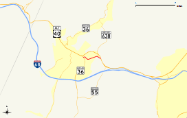
Route information Maintained by MDSHA Length: 1.00 mi[1] (1.61 km) Major junctions West end:  MD 36 in Frostburg
 MD 638 in Eckhart Mines
East end: 
 US 40 Alt. in Eckhart Mines
Location Counties: Allegany Highway system Maryland highway system
Interstate • US • State • Minor • Former • Turnpikes←  MD 736
MD 750  →
→Maryland Route 743 (MD 743) is a state highway in the U.S. state of Maryland. The state highway runs 1.00 mile (1.61 km) from MD 36 in Frostburg east to U.S. Route 40 Alternate (US 40 Alternate) in Eckhart Mines. MD 743 is the original alignment of US 40 through Eckhart Mines. The state highway was designated when US 40 bypassed Eckhart Mines around 1950.
Contents
Route description
MD 743 begins at an intersection with MD 36 (New Georges Creek Road) in Frostburg just south of MD 36's southern intersection with US 40 Alternate. The state highway heads east into the unincorporated village of Eckhart Mines as a winding two-lane road. After intersecting MD 638 (Parkersburg Road) at an acute angle, MD 743 reaches its eastern terminus at US 40 Alternate (National Pike).[1][2]
History
MD 743 is the original alignment of US 40 and, before that, the National Road through Eckhart Mines. The highway was one of the original state roads scheduled for improvement by the Maryland State Roads Commission in 1909.[3] The state road was paved through the village in 1911.[4][5] MD 743 was designated through Eckhart Mines shortly after the US 40 (now US 40 Alternate) bypass of the village was completed around 1950.[6][7] MD 743 originally extended west to US 40, meeting the highway on a tangent in front of Mountain Ridge High School at the city limit of Frostburg.[7] The western end of the state highway was truncated when MD 36 was moved to its present alignment between Midland and Frostburg in 1972.[8]
Junction list
The entire route is in Allegany County.
Location Mile[1] Destinations Notes Frostburg 0.00 MD 36 (New Georges Creek Road) – WesternportWestern terminus Eckhart Mines 0.90 MD 638 (Parkersburg Road) – Mount Savage1.00
US 40 Alt. (National Pike) – Frostburg, CumberlandEastern terminus 1.000 mi = 1.609 km; 1.000 km = 0.621 mi References
- ^ a b c "Highway Location Reference: Allegany County" (PDF). Maryland State Highway Administration. 2009. http://www.marylandroads.com/Location/2009_ALLEGANY.pdf. Retrieved 2010-11-02.
- ^ Google, Inc. Google Maps – Maryland Route 743 (Map). Cartography by Google, Inc. http://maps.google.com/maps?f=d&source=s_d&saddr=MD-36+N&daddr=Old+National+Pike+SW+to:Old+National+Pike+SW&hl=en&geocode=FSoDXQIdIuxL-w%3BFfoFXQIduh9M-w%3BFcoAXQIdNixM-w&mra=ls&sll=39.649897,-78.900869&sspn=0.00755,0.01929&ie=UTF8&ll=39.649732,-78.902221&spn=0.00755,0.01929&t=h&z=16. Retrieved 2010-06-11.
- ^ Maryland Geological Survey. Map of Maryland (Map) (1910 ed.).
- ^ Maryland Geological Survey. Map of Maryland: Showing State Road System and State Aid Roads Completed or Under Construction December 31, 1911 (Map) (1911 ed.).
- ^ Report of the State Roads Commission of Maryland. 1912-1915. Baltimore: Maryland State Roads Commission. May 1915. p. 108. http://www.archive.org/details/annualreportsofs1912mary. Retrieved 2010-11-04.
- ^ Report of the State Roads Commission of Maryland. 1949-1950. Baltimore: Maryland State Roads Commission. 1950-12-20. p. 168. http://www.archive.org/details/reportofstateroa1949mary. Retrieved 2010-11-04.
- ^ a b United States Geological Survey. Frostburg quadrangle (Map). 1:48,000. 15 Minute Series (Topographic) (1950 ed.). http://historical.mytopo.com/quad.cfm?quadname=Frostburg&state=MD&series=15. Retrieved 2010-11-04.
- ^ Maryland State Highway Administration. Maryland: Official Highway Map (Map) (1972 ed.).
External links
Roads in Allegany County, Maryland State highways 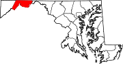
U.S. Highways Interstate Highways Categories:- State highways in Maryland
- Roads in Allegany County, Maryland


Wikimedia Foundation. 2010.