- Midland, Maryland
-
Midland, Maryland — Town — Location of Midland, Maryland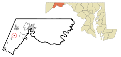
Coordinates: 39°35′23″N 78°56′56″W / 39.58972°N 78.94889°WCoordinates: 39°35′23″N 78°56′56″W / 39.58972°N 78.94889°W Country United States State Maryland County Allegany Area – Total 0.2 sq mi (0.5 km2) – Land 0.2 sq mi (0.5 km2) – Water 0.0 sq mi (0.0 km2) Elevation 1,713 ft (522 m) Population (2000) – Total 727 – Density 2,500.3/sq mi (965.4/km2) Time zone Eastern (EST) (UTC-5) – Summer (DST) EDT (UTC-4) ZIP code 21542 Area code(s) 301 FIPS code 24-52475 GNIS feature ID 0585837 Midland is a town in Allegany County, Maryland, United States, located along the Georges Creek Valley. It is part of the Cumberland, MD-WV Metropolitan Statistical Area. The population was 473 at the 2000 census.
The town of Midland is 1,600 feet (490 m) above sea level, is located 5 miles (8.0 km) south of Frostburg, Maryland and 3 miles (4.8 km) north of Lonaconing, Maryland. Paradise Run and Neff's Run carry the precipitation from Dan's Mountain on the east to Georges Creek, while Squirrel Neck Run feeds it from the west off of Savage Mountain. Some say that Midland derived its name from its location, some say it was named after the Midlands in Scotland by the Scottish settlers.
Midland is the birthplace of the Emmy Award winning longtime American actress Suzanne Rogers, who has played the role of Maggie Simmons Horton on NBC's Days of our Lives continuously since 1973.
Midland is proud of its two churches—St. Joseph's Catholic Church and Grace United Methodist Church. Both were established in 1891. The bells of St. Joe’s and the chimes of Grace ring out daily from the hill at the edge of town where the churches sit side by side.
About 3 miles beyond the town's limits, anyone making the climb to the top of the magnificent outcropping known as Dan's Rock is rewarded with an incomparable view of the eastern end of the county and nearby West Virginia. Generations of townsfolk and visitors have marveled at the spectacular sunrises and sunsets seen from this highest point in Allegany County.
Midland was founded in 1850 as a coal-mining community in the heart of the George's Creek Valley, once a major center of the nation’s coal industry. But coal production started to decline after World War I, and today only some strip mining remains as the last vestige of this once all important industry. Coal trains that once went through the town daily are gone now.
Most of the original settlers came in response to the abundance of jobs available in the coal mines. Many were Irish, but German, Scottish, and Welsh names also are found in the early records of the town.
Once a bustling town with big stores, a hotel, and an opera house, Midland today projects a friendly laid-back atmosphere. A convenience store offers the basic necessities, but major shopping is done in the larger communities of Frostburg, LaVale, and Cumberland. The post office in the heart of town is the gathering point for the townspeople to meet and chat.
Contents
History
The history of Midland is vague before 1850. According to the Heritage Press there were some early pioneers who lived in caves and covered wagons while building their log cabins in the area now known as Midland. George Winters, an Englishman, who originally settled in Pennsylvania, later moved to Frederick, and then moved west to establish a home in Midland sometime before 1765.The VanBuskirk (Buskirk) family built a stone house in about 1790 about 2 miles (3.2 km) south of Midland. Early Catholic services were held in this house, and worshipers traveled on foot from the surrounding area for 5 miles (8.0 km) to attend. This stone house was later inhabited by Miss Virginia Brummage.
In the latter part of the 18th century, the Combs family settled on the farm which is now the home of Clarence O. Miller.
In 1826 Henry Koontz built a greystone house of logs and stone gathered from the land surrounding the area. This home's later residents (1975) were Mrs. Marie Winters and her sister, Francis Winters. Mr. Salem Koontz and his wife, Birdie, moved from the farm to their newly built colonial home in the Koontz orchard, which is now a part of Midland. This was later inhabited by Mrs. Arch "Sweetie" Dixon, granddaughter of Salem & Birdie, who was born in the house. Succeeding owners of this home were Mr. John Kenny and Mr. & Mrs. Gary Eagan. Thus, Midland was originally called "Koontz".
Earlier writings regarding the early days of Midland refer to a Staup farm located on the present site of the town. One of the first dwelling, a log house, was located on Paradise Street opposite the home of William Kroll. This house was occupied by a farmer and a woodsman named Staup. In 1863 the heirs of George Staup, Mary A., Peter and William, sold a tract of land to Thomas Gimmel for $7,000. This land was named "The resurvey of the Elk Lick". Later inhabitants of this home were Bob and Lucy Loar.
The Firlie family bought many acres in this same vicinity, but failed to buy the mineral rights which, according to Carl Firlie of Cumberland, Maryland, were offered to his grandfather for an additional $100.
Another early family of the area was the Cutters. In the 1850s Henry Cutter and his wife immigrated from Germany and built a log cabin on the site of the present Hartman farm. In this log cabin, in 1859, John Barney Cutter was born. He was one of 14 children.
Around 1850, two enterprising Scottish brother, Alexander and Thomas Gimmel, organized the Hampshire and Baltimore Coal Company. The location of their mine was directly behind the site of the Midland School. In 1859 they built a row of brick homes facing the Cumberland and Pennsylvania Railroad. Only 2 of these houses are still standing, completely renovated.
It was an opportune time for the founding of Midland, the youngest of the "Creek" or "Crick" towns. Westernport, Barton and Lonaconing had been settled much earlier. The Georges Creek Coal Company had built a railroad from Piedmont to Knapp's Meadow to link the newly opened coal fields with the Eastern city markets by way of the Baltimore and Ohio Railroad which had been extended from Cumberland to Piedmont in 1851. The Cumberland and Pennsylvania Railroad, after purchasing the Georges Creek Coal and Iron Railroad, completed the laying of track from Cumberland to Knapp's Meadow so that the valley from Cumberland to Westernport, by way of Mt. Savage, had the means of transporting the coal.
From 1874, the town steadily grew. Shortly after 1900 the Koontz Addition was filled with residences. The first grocery business was run by a man named Shearer. Later, Sandy Tennant built and operated an independent grocery business. Later there was a butcher shop owned and operated by John J.Devlin. This shop is now the town's Post Office.
In 1900, C.T. Clayton began publishing a weekly newspaper in the Knights of Labor Hall.
One of the early department stores operated by J. R. Poland dispensed news and advertised items in a small news sheet known as the Midland News.
Coal mining
From Frostburg to Westernport lay 16 miles (26 km) of land that contained some of the richest semi-bituminous coal deposits in the country. The two principal veins were (1) the Pittsburgh or Big Vein deposit which was 14' high and 200' below the surface, and (2) the Tyson or Small Vein deposit which was up to 6' high and 100 feet (30 m) below the surface.
Little towns sprang up along the Georges Creek Valley, attracting new settlers who came to dig the coal. To an outsider, these towns would seem very much alike, but each had its own distinct character. Using pick and shovel, sometimes explosives, the Irish, Scots, Welsh and Germans descended into the bowels of the earth to extract the shiny black fuel from the underground vastness.
Two Scotsmen, Alexander and Thomas Gimmel, organized the Hampshire and Baltimore Coal Company and opened a mine behind what later became Midland School. This mine would be bought by the George's Creek Coal Company who later leased it to Bob Loar and Charlie Eagan. In the 1930s, the mine was operated by the Sloan family from Lonaconing.
The Medicine Mine was located about 1/2 mile out of town on the new Route 36, opposite the home of Mr. & Mrs. William Fisher. It was originally owned by the Midland Mining Company, which was run by William Sommerville. It was later sold to John Ashley who later sold it to "Tug" Hughes and Chalmer Winner.
Number 8 Mine was on the hillside above the ball park. It was owned by the Consolidated Coal Co. of Pittsburgh. Arthur Winner remembers a wooden trestle that began near the Knippenberg home at the southern end of Railroad St. and crossed over Georges' Creek to Number 8.
The largest mine of all was Ocean Mines just north of town on Route 936. It was also owned by the Consolidated Coal Company. It was a sprawling complex of buildings, sheds, and a large covered entrance structure. At one time the mines at Ocean and Klondike employed 1,500 men working three shifts. By 1900, about 5,000 men worked in the deep mines of George's Creek. The coal from Ocean Mines was used primarily by the large ocean liners because of its unique smokeless quality, thus the name "Ocean Mines".
Nearby communities
- Cumberland, Maryland
- Lonaconing, Maryland
- Frostburg, Maryland
- Barton, Maryland
- Cresaptown-Bel Air, Maryland
- Westernport, Maryland
- Piedmont, West Virginia
- LaVale, Maryland
- Keyser, West Virginia
Geography
Midland is located at 39°35′23″N 78°56′56″W / 39.58972°N 78.94889°W (39.589842, -78.948772)[1].
According to the United States Census Bureau, the town has a total area of 0.2 square miles (0.52 km2), all of it land.
Demographics
As of the census[2] of 2000, there were 473 people, 189 households, and 123 families residing in the town. The population density was 2,500.3 people per square mile (961.2/km²). There were 211 housing units at an average density of 1,115.4 per square mile (428.8/km²). The racial makeup of the town was 99.37% White and 0.63% Asian. Hispanic or Latino of any race were 0.42% of the population.
There were 189 households out of which 26.5% had children under the age of 18 living with them, 52.9% were married couples living together, 10.6% had a female householder with no husband present, and 34.4% were non-families. 30.7% of all households were made up of individuals and 20.6% had someone living alone who was 65 years of age or older. The average household size was 2.49 and the average family size was 3.10.
In the town the population was spread out with 20.9% under the age of 18, 11.4% from 18 to 24, 24.7% from 25 to 44, 25.4% from 45 to 64, and 17.5% who were 65 years of age or older. The median age was 40 years. For every 100 females there were 84.8 males. For every 100 females age 18 and over, there were 84.2 males.
The median income for a household in the town was $32,404, and the median income for a family was $37,500. Males had a median income of $26,750 versus $22,115 for females. The per capita income for the town was $19,318. About 6.2% of families and 8.1% of the population were below the poverty line, including 9.0% of those under age 18 and 9.8% of those age 65 or over.
See also
- Category:Businesses located in Cumberland, MD-WV
References
- ^ "US Gazetteer files: 2010, 2000, and 1990". United States Census Bureau. 2011-02-12. http://www.census.gov/geo/www/gazetteer/gazette.html. Retrieved 2011-04-23.
- ^ "American FactFinder". United States Census Bureau. http://factfinder.census.gov. Retrieved 2008-01-31.
Municipalities and communities of Allegany County, Maryland Cities 
Towns Barton | Lonaconing | Luke | Midland | Westernport
CDPs Other
communitiesAmcelle | Barrelville | Bel Air | Bellegrove | Bier | Borden Shaft | Bowling Green | Carlos | Clarysville | Corriganville | Cresaptown | Danville | Dawson | Detmold | Dickens | Eckhart Mines | Ellerslie | Evitts Creek | Flintstone | Franklin | George's Creek | Klondike | Little Orleans | McCoole | McKenzie | Mexico | Midlothian | Moscow | Mount Savage | Narrows Park | Nikep | North Branch | Oldtown | Pekin | Pinto | Pleasant Valley | Potomac Park | Rawlings | Spring Gap | Town Creek | Vale Summit | Woodland | Zihlman
Categories:- Towns in Maryland
- Populated places in Allegany County, Maryland
- Georges Creek Valley
- Populated places in the Cumberland, MD-WV MSA
- Cumberland, MD-WV MSA


Wikimedia Foundation. 2010.