- Clarysville, Maryland
-
Clarysville — Unincorporated town — Location within the state of Maryland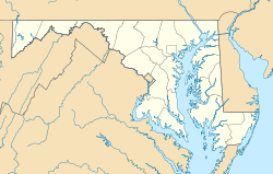

Coordinates: 39°38′31″N 78°53′11″W / 39.64194°N 78.88639°WCoordinates: 39°38′31″N 78°53′11″W / 39.64194°N 78.88639°W Country United States State Maryland County Allegany Time zone Eastern (EST) (UTC-5) – Summer (DST) EDT (UTC-4) ZIP codes FIPS code GNIS feature ID Clarysville is an unincorporated town in Allegany County, Maryland, USA. It is located along U.S. Route 40 Alternate, at its intersection with Maryland Route 55. Clarysville was known around the region for the Clarysville Inn, a historic building which stood in Clarysville from 1807 until it burned in 1999.[1] The Clarysville Inn during the American Civil War served as a military hospital, treating wounded soldiers.[2]
The exit of the Hoffman drainage tunnel, constructed to drain several coal mines, is near Clarysville.
References
Municipalities and communities of Allegany County, Maryland Cities 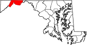
Towns Barton | Lonaconing | Luke | Midland | Westernport
CDPs Other
communitiesAmcelle | Barrelville | Bel Air | Bellegrove | Bier | Borden Shaft | Bowling Green | Carlos | Clarysville | Corriganville | Cresaptown | Danville | Dawson | Detmold | Dickens | Eckhart Mines | Ellerslie | Evitts Creek | Flintstone | Franklin | George's Creek | Klondike | Little Orleans | McCoole | McKenzie | Mexico | Midlothian | Moscow | Mount Savage | Narrows Park | Nikep | North Branch | Oldtown | Pekin | Pinto | Pleasant Valley | Potomac Park | Rawlings | Spring Gap | Town Creek | Vale Summit | Woodland | Zihlman
Categories:- Populated places in Allegany County, Maryland
- Unincorporated communities in Maryland
- Populated places in the Cumberland, MD-WV MSA
- Cumberland, MD-WV MSA
- Maryland geography stubs


Wikimedia Foundation. 2010.