- Western Maryland
-
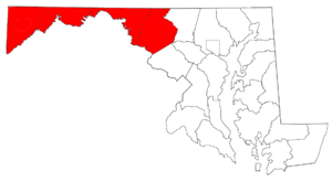
Western Maryland is the portion of the U.S. state of Maryland that consists of Frederick, Washington, Allegany, and Garrett counties. The region is bounded by the Mason-Dixon line to the north, Preston County, West Virginia to the west, and the Potomac River to the south. There is dispute over the eastern boundary of Western Maryland however. For most residents of the Baltimore-Washington area, everything west of Frederick city is considered Western Maryland. However, the people of the more mountainous and isolated Allegany County and Garrett County consider Sideling Hill the boundary between Western Maryland and what they refer to as "down-state." According to the Census Bureau's 2007 dataset, Western Maryland (including Washington and Frederick counties) has a population of 472,039, accounting for 8.4% of the population of Maryland. Its land area is 2,194.39 square miles (5,683.4 km2), or 22.45% percent of the state's land area. Only 21.7% of Western Maryland's residents live in the geographically isolated Allegany and Garrett counties; the other 78.3% live in suburban Frederick and Washington counties.
Western Maryland is far more rural than the Baltimore-Washington Metropolitan Area, where most of the state's population lives; even Frederick and Washington counties, which are part of the Metro Area, are less urbanized than places closer to Washington, D.C. and Baltimore. Many people still perform a variety of subsistence agriculture for their food needs, and there are few towns larger than 10,000 people, the most notable exceptions being Cumberland, Frederick and Hagerstown. Western Maryland is noted for its idyllic rural landscapes in its eastern portion and the mountainous terrain in Allegany and Garrett Counties. The area is generally regarded as part of Appalachia,[1][2] with the extreme western section having more of an affinity to Pittsburgh than the rest of the state. Garrett County, the state's westernmost county, largely aligns itself through marketing and sports with West Virginia and the Pittsburgh area rather than Maryland.
The climate is more akin to the mountains of northern West Virginia than to any other part of Maryland. Summers tend to be much cooler than in the rest of the state, and winters harsher. Temperatures in winter often drop to near or below 0 F (-18°C), and snowfall averages from 20 inches farther east to over 120 inches in the higher elevations. Comparably, Prince George's County, in the eastern part of the Washington, D.C. area, averages only 25 inches of snow and wintertime temperatures many times exceed 50 F (10°C).
Western Maryland has a heavily agricultural economy. Its best-known crops are the apples grown in the Allegany Valley, but corn, potatoes, beans, and varieties of green-leaf vegetables are grown as well. Mixed crop and livestock farms are common, and the region has a large number of dairy cattle farms. There is however, a thriving tourist industry, and places such as Deep Creek Lake in Garrett County are frequented by many visitors every year. Garrett County is also well-known for its numerous state parks and outdoor activities. Maryland's only ski resort, Wisp Ski Resort, is located in Garrett County near Oakland.
Contents
Major communities
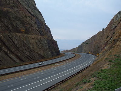
 Sideling Hill man-made mountain pass on Interstate 68/U.S. Route 40 in the central part of Western Maryland near Hancock.
- Boonsboro
- Brunswick
- Cumberland
- Emmitsburg
- Frederick
- Frostburg
- Hagerstown
- Hancock
- Middletown
- Mount Airy
- Mountain Lake Park
- Oakland
- Smithsburg
- Thurmont
- Walkersville
- Westernport
- Williamsport
See also
- List of Appalachian Regional Commission counties#Maryland
Notes
- ^ Hazen, Kirk (2000). "The Appalachian Language Bibliography". http://www.as.wvu.edu/~khazen/APPBIB2_2.htm. Retrieved 2007-12-08.
- ^ Hogg, Richard M.; Denison, David (2006). A History of the English Language. Cambridge University Press. pp. 386–387. ISBN 0521662273. http://books.google.com/?id=U5FDi8WksqYC&pg=PA387&lpg=PA387&dq=linguistics+%22western+maryland%22. Retrieved 2007-12-08
External links
- Western Maryland Scenic Railroad Official Website for the Scenic Railroad and Canal Place.
- Western Maryland Tourism Website MDMountainside.com
- Rocky Gap Resort Western Maryland Park with Lake & Golf Course
- Heritage Days Festival
- Canal Place
- Queen City Striders Running Club
- Western Maryland Mountain Bike Association
- Western Maryland Water Color Society
Municipalities and communities of Allegany County, Maryland Cities Towns Barton | Lonaconing | Luke | Midland | Westernport
CDPs Other
communitiesAmcelle | Barrelville | Bel Air | Bellegrove | Bier | Borden Shaft | Bowling Green | Carlos | Clarysville | Corriganville | Cresaptown | Danville | Dawson | Detmold | Dickens | Eckhart Mines | Ellerslie | Evitts Creek | Flintstone | Franklin | George's Creek | Klondike | Little Orleans | McCoole | McKenzie | Mexico | Midlothian | Moscow | Mount Savage | Narrows Park | Nikep | North Branch | Oldtown | Pekin | Pinto | Pleasant Valley | Potomac Park | Rawlings | Spring Gap | Town Creek | Vale Summit | Woodland | Zihlman
Municipalities and communities of Frederick County, Maryland Cities Towns Burkittsville | Emmitsburg | Middletown | Mount Airy‡ | Myersville | New Market | Thurmont | Walkersville | Woodsboro
Village CDPs Other
communitiesAdamstown | Buckeystown | Catoctin Furnace | Creagerstown | Fairhaven | Fairview | Graceham | Ijamsville | Jefferson | Johnsville | Knoxville | Ladiesburg | Lewistown | Libertytown | Lake Linganore | Monrovia | New London | New Midway | Point of Rocks | Rocky Ridge | Sabillasville | Sherwood Forest | Spoolsville | Sunny Side | Tuscarora | Unionville | Urbana | Wolfsville
Footnotes ‡This populated place also has portions in an adjacent county or counties
Municipalities and communities of Garrett County, Maryland Towns Unincorporated
communitiesMunicipalities and communities of Washington County, Maryland City Towns Boonsboro | Clear Spring | Funkstown | Hancock | Keedysville | Sharpsburg | Smithsburg | Williamsport
CDPs Other
communitiesAntietam | Beaver Creek | Benevola | Big Pool | Broadfording | Brownsville | Burtner | Cearfoss | Cedar Grove | Dargan | Downsville | Eakles Mills | Fairplay | Fairview | Gapland | Huyett | Indian Springs | Jugtown | Mapleville | Mercersville | Park Hall | Pecktonville | Pen Mar | Pinesburg | Ringgold | Samples Manor | Sandy Hook | Spielman | Trego | Van Lear | Weverton | Woodmont
United States panhandles Alaska • Connecticut • Florida • Idaho • Maryland • Nebraska • Oklahoma • Texas • Eastern West Virginia • Northern West VirginiaCoordinates: 39°41′40.23″N 77°52′15.94″W / 39.6945083°N 77.8710944°W
Categories:- Regions of Maryland
Wikimedia Foundation. 2010.


