- Dorchester County, Maryland
-
Coordinates: 38°25′N 76°05′W / 38.42°N 76.08°W
Dorchester County, Maryland 
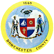
Seal
Location in the state of Maryland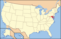
Maryland's location in the U.S.Founded 1669 Seat Cambridge Area
- Total
- Land
- Water
982.92 sq mi (2,546 km²)
557.54 sq mi (1,444 km²)
425.38 sq mi (1,102 km²), 43.28%Population
- (2010)
- Density
32,618
58/sq mi (22.5/km²)Time zone Eastern: UTC-5/-4 Website www.docogonet.com Dorchester County is a county located in the U.S. state of Maryland on its Eastern Shore. It is bordered by the Choptank River to the north, Talbot County to the northwest, Caroline County to the northeast, Wicomico County to the southeast, Sussex County, Delaware, to the east, and the Chesapeake Bay to the west. Dorchester County uses the slogan, "The Heart of Chesapeake Country," due to its geographical location and the heart-like shape of the county on a map. In 2010, its population was 32,618. It was named for the Earl of Dorset, a family friend of the Calverts (the founding family of the Maryland colony). Its county seat is Cambridge.
Contents
Law and government
Dorchester County operates under the Charter Home Rule form of government and the affairs of the County are managed by five County Council Members, one from each of the five Council districts defined within the County. Meetings of the County Council are held weekly. The agenda and the minutes of each week’s proceedings are public record.[1]
Law Enforcement
The county is policed by the Dorchester County Sheriff's Office (DCSO), the Maryland State Police, and the DNR Police. The DCSO is a full service agency, currently headed by Sheriff James W. Phillips Jr..[2]
History
Dorchester County, Maryland is the birthplace of Harriet Tubman.
Geography
According to the 2000 census, the county has a total area of 982.92 square miles (2,545.8 km2), the largest county in Maryland, of which 557.54 square miles (1,444.0 km2) (or 56.72%) is land and 425.38 square miles (1,101.7 km2) (or 43.28%) is water.[3]
Adjacent counties
- Caroline County (north)
- Sussex County, Delaware (northeast)
- Wicomico County (east)
- Somerset County (southeast)
- Talbot County (northwest)
National protected area
Demographics
Historical populations Census Pop. %± 1790 15,875 — 1800 16,346 3.0% 1810 18,108 10.8% 1820 17,759 −1.9% 1830 18,686 5.2% 1840 18,843 0.8% 1850 18,877 0.2% 1860 20,461 8.4% 1870 19,458 −4.9% 1880 23,110 18.8% 1890 24,843 7.5% 1900 27,962 12.6% 1910 28,669 2.5% 1920 27,895 −2.7% 1930 26,813 −3.9% 1940 28,006 4.4% 1950 27,815 −0.7% 1960 29,666 6.7% 1970 29,405 −0.9% 1980 30,623 4.1% 1990 30,236 −1.3% 2000 30,674 1.4% 2010 32,618 6.3% 2010
Whereas according to the 2010 U.S. Census Bureau:
- 67.6% White
- 27.7% Black
- 0.3% Native American
- 0.9% Asian
- 0.0% Native Hawaiian or Pacific Islander
- 1.9% Two or more races
- 1.2% Other races
- 3.5% Hispanic or Latino (of any race)
2000
As of the census[4] of 2000, there were 30,674 people, 12,706 households, and 8,500 families residing in the county. The population density was 55 people per square mile (21/km²). There were 14,681 housing units at an average density of 26 per square mile (10/km²). The racial makeup of the county was 69.45% White, 28.39% Black or African American, 0.23% Native American, 0.66% Asian, 0.00% Pacific Islander, 0.39% from other races, and 0.89% from two or more races. 1.26% of the population was Hispanic or Latino of any race. 20.1% were of American, 12.7% English, 9.8% German and 8.2% Irish ancestry according to Census 2000.
There were 12,706 households out of which 27.30% had children under the age of 18 living with them, 47.50% were married couples living together, 15.50% had a female householder with no husband present, and 33.10% were non-families. 28.20% of all households were made up of individuals and 13.50% had someone living alone who was 65 years of age or older. The average household size was 2.36 and the average family size was 2.86.
In the county the population was spread out with 23.30% under the age of 18, 6.70% from 18 to 24, 26.80% from 25 to 44, 25.50% from 45 to 64, and 17.70% who were 65 years of age or older. The median age was 41 years. For every 100 females there were 89.80 males. For every 100 females age 18 and over, there were 86.40 males.
The median income for a household in the county was $34,077, and the median income for a family was $41,917. Males had a median income of $29,014 versus $22,284 for females. The per capita income for the county was $18,929. 13.80% of the population and 10.10% of families were below the poverty line. 18.10% of those under the age of 18 and 14.20% of those 65 and older were living below the poverty line.[5]
As of 2010 the racial makeup of the county was 66.16% Non-Hispanic whites, 27.70% blacks, 0.34% Native Americans, 0.92% Asians, 0.03% Pacific Islanders, 0.09% Non-Hispanics from some other race, 1.64% Non-Hispanics reporting two or more races and 3.64% Hispanic or Latino.
Education
Public schools
- Dorchester County School of Technology
- North Dorchester High School
- Cambridge-South Dorchester High School
- Mace's Lane Middle School
- North Dorchester Middle School
- Sandy Hill Elementary School
- Choptank Elementary School
- Hurlock Elementary School
- Maple Elementary School
- South Dorchester PK-8
- Vienna Elementary School
- Warwick Elementary School
Cities and towns
This county contains the following incorporated municipalities:
- 1 City:
- Cambridge (incorporated 1793)
- 8 Towns:
- Brookview (incorporated 1953)
- Church Creek (incorporated 1867)
- East New Market (incorporated 1832)
- Eldorado (incorporated 1947)
- Galestown (incorporated 1951)
- Hurlock (incorporated 1892)
- Secretary (incorporated 1900)
- Vienna (incorporated 1833)
Sister Counties
 - Düren (district), since 2005
Media
The local newspapers are The Daily Banner and The Dorchester Star (a free, weekly publication). A regional newspaper, The Star Democrat, serves several counties including Dorchester.
See also
References
- ^ Dorchester County, Maryland - Overview & History
- ^ Dorchester County, Maryland - Dorchester County Sheriff's Department
- ^ "Census 2000 U.S. Gazetteer Files: Counties". United States Census. http://www.census.gov/tiger/tms/gazetteer/county2k.txt. Retrieved 2011-02-13.
- ^ "American FactFinder". United States Census Bureau. http://factfinder.census.gov. Retrieved 2008-01-31.
- ^ Dorchester County QuickFacts from the US Census Bureau
External links

Talbot County Caroline County Sussex County, Delaware Chesapeake Bay 
Wicomico County  Dorchester County, Maryland

Somerset County Municipalities and communities of Dorchester County, Maryland City 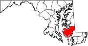
Towns Brookview | Church Creek | East New Market | Eldorado | Galestown | Hurlock | Secretary | Vienna
CDP Other
communitiesAirey | Bishops Head | Crapo | Crocheron | Elliott-Salem | Fishing Creek | Hoopersville | Linkwood | Madison | Reliance‡ | Rhodesdale | Taylors Island | Toddville | Waddells Corner | Whitehall | Williamsburg | Wingate | Woolford
Footnotes ‡This populated place also has portions in an adjacent county or counties
Law enforcement agencies in Maryland State County Departments Municipal Departments Aberdeen · Annapolis · Baltimore Police Department · Bel Air Police Department · Bowie · Cumberland · District Heights · Greenbelt · Hagerstown · Landover Hills · Laurel · Ocean City · Rockville · Salisbury · Seat Pleasant · Takoma · University Park · Upper MarlboroSheriff's Offices University Bowie State · Frostburg State · Salisbury · Towson · University of Baltimore · University of Maryland, Baltimore County · University of Maryland, College Park Police DepartmentCategories:- Maryland counties
- Dorchester County, Maryland
- 1669 establishments


Wikimedia Foundation. 2010.