- Howard County, Maryland
-
Howard County, Maryland 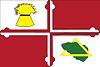
Flag
Seal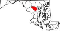
Location in the state of Maryland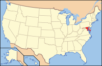
Maryland's location in the U.S.Founded 1838 Named for John Eager Howard Seat Ellicott City Area
- Total
- Land
- Water
253.55 sq mi (657 km²)
252.04 sq mi (653 km²)
1.51 sq mi (4 km²), 0.60%Population
- (2010)
- Density
287,085
1,139/sq mi (439.6/km²)Congressional districts 3, 7 Time zone Eastern: UTC-5/-4 Website www.co.ho.md.us Howard County is a county located in the central part of the U.S. state of Maryland, between Baltimore and Washington, D.C. It is considered part of the Baltimore-Washington Metropolitan Area.
In 2010, its population was 287,085. Its county seat is Ellicott City. The center of population of Maryland is located on the county line between Howard County and Anne Arundel County, in the unincorporated town of Jessup.[1]
Due to the proximity of Howard County's population centers to Baltimore, the county has traditionally been considered a part of the Baltimore Metropolitan Area. Recent development in the south of the county has led to some realignment towards the Washington, D.C. media and employment markets. The county is also home to Columbia, a major planned community of 100,000 founded by developer James Rouse in 1967.
Howard County is frequently cited for its affluence, quality of life, and excellent schools. For 2011, it was ranked the fifth wealthiest county by median household income in the United States by the U.S. Census Bureau. Many of the most affluent communities in the Baltimore-Washington Metropolitan Area, such as Clarksville, Glenelg, Glenwood and West Friendship, are located along the Route 32 corridor in Howard County. The main population center of Columbia/Ellicott City was named 2nd among Money magazine's 2010 survey of "America's Best Places to Live."[2] Howard County's schools frequently rank first in Maryland as measured by standardized test scores and graduation rates.[3]
Contents
History
In 1800, the mean center of U.S. population as calculated by the US Census Bureau was found in what is now Howard County.[4]
To honor John Eager Howard, an officer in the American Revolutionary War and later the fifth Governor of Maryland,[5], the area was designated the Howard District when Anne Arundel County was divided in 1839. The Howard District had the same status as a county except that it was not separately represented in the Maryland General Assembly. In 1851, the district became Howard County.
The county has a number of properties on the National Register of Historic Places.[6]
Geography
Howard County is located in the Maryland Piedmont region, with rolling hills making up most of the landscape. Its largest community is Columbia, which is not an incorporated city under Maryland law; in fact, Howard County has no incorporated municipalities. The northern portion of Howard County is part of the outskirts of Baltimore, while the southern is more oriented toward Washington, D.C.
According to the 2000 census, the county has a total area of 253.55 square miles (656.7 km2), the smallest county in Maryland, of which 252.04 square miles (652.8 km2) (or 99.40%) is land and 1.51 square miles (3.9 km2) (or 0.60%) is water.[7]
Adjacent counties
- Anne Arundel County (southeast)
- Baltimore County (northeast)
- Carroll County (north)
- Frederick County (northwest)
- Montgomery County (west)
- Prince George's County (south)
Climate
Howard County lies in the transition between the Humid subtropical climate zone and the Humid continental climate zone. The easternmost tip of the county has a true subtropical climate, with hot, humid summers and cool, rainy winters. As one travels west in the county away from the Baltimore area, the winter temperatures get lower and snow is more common. Annual rainfall is about 45 inches (1,100 mm) throughout the county.[8] Over a 50 year period from 1950 to 2010, there were 394 National Climatic Data Center reportable events causing 617 injuries, and 99 fatalities. There were 9 reported tornadoes, reaching a maximum of F2 with no recorded fatalities.[9]
Demographics
Historical populations Census Pop. %± 1860 13,338 — 1870 14,150 6.1% 1880 16,140 14.1% 1890 16,269 0.8% 1900 16,715 2.7% 1910 16,106 −3.6% 1920 15,826 −1.7% 1930 16,169 2.2% 1940 17,175 6.2% 1950 23,119 34.6% 1960 36,152 56.4% 1970 61,911 71.3% 1980 118,572 91.5% 1990 187,328 58.0% 2000 247,842 32.3% 2010 287,085 15.8% 2010
Whereas according to the 2010 U.S. Census Bureau:
- 62.2% White
- 17.5% Black
- 0.3% Native American
- 14.4% Asian
- 0.0% Native Hawaiian or Pacific Islander
- 3.6% Two or more races
- 2.0% Other races
- 5.8% Hispanic or Latino (of any race)
2000
As of the census[10] of 2000, there were 247,842 people, 90,043 households, and 65,821 families residing in the county. The population density was 983 people per square mile (380/km²). There were 92,818 housing units at an average density of 368 per square mile (142/km²). The racial makeup of the county was 74.33% White, 14.42% Black or African American, 0.24% Native American, 7.68% Asian, 0.04% Pacific Islander, 1.11% from other races, and 2.19% from two or more races. 3.02% of the population were Hispanic or Latino of any race. 15.1% were of German, 11.0% Irish, 9.3% English, 6.6% Italian and 5.7% American ancestry according to Census 2000.
There were 90,043 households out of which 40.00% had children under the age of 18 living with them, 60.50% were married couples living together, 9.50% had a female householder with no husband present, and 26.90% were non-families. 20.80% of all households were made up of individuals and 4.60% had someone living alone who was 65 years of age or older. The average household size was 2.71 and the average family size was 3.18.
In the county the population was spread out with 28.10% under the age of 18, 6.30% from 18 to 24, 34.40% from 25 to 44, 23.80% from 45 to 64, and 7.50% who were 65 years of age or older. The median age was 36 years. For every 100 females there were 96.60 males. For every 100 females age 18 and over, there were 92.90 males.
The median income for a household in the county was $101,003, and the median income for a family was $117,186 in 2009[11]). The per capita income was $44,120. About 2.70% of families and 4.00% of the population were below the poverty line.
Population history
The following is a population history for Howard County from the U.S. Census Bureau.[12] The ranking compares the population of Howard County to those of the other 23 Maryland counties and Baltimore City.[13][14]
- 1870.......14,150......19th
- 1900.......16,715......22nd (Calvert and Caroline fewer)
- 1910.......16,106......23rd (Calvert fewer)
- 1920.......15,826......22nd (Calvert and Kent fewer)
- 1930.......16,169......19th (Calvert, Charles, Kent, Queen Anne's, St. Mary's fewer)
- 1940.......17,175......20th (Calvert, Kent, Queen Anne's, St. Mary's fewer)
- 1950.......23,119......18th (Calvert, Caroline, Garrett, Kent, Queen Anne's, Somerset, Talbot fewer)
- 1960.......36,152......14th (Calvert, Caroline, Charles, Dorchester, Garrett, Kent, Queen Anne's, Somerset, Talbot, Worcester fewer)
- 1970.......61,911......11th (Howard passing Cecil, St. Mary's, Wicomico in population)
- 1980......118,572......7th (after only Anne Arundel, Baltimore County and City, Harford, Montgomery, Prince George's)
- 1990......187,328......6th (passing Harford)
- 2000......247,842......6th
- 2004......266,738......6th
- 2008......274,995
Education and public library
The Howard County Public School System manages 71 schools and serves approximately 49,000 students. The graduation rate from this school district is an above-average 92%, and the county's schools are ranked among the best in the state. Student test scores consistently top the list for all Maryland school districts. Public school construction has kept pace with the county’s growth in recent years in an effort to safeguard against crowded classrooms. Howard High School is currently the largest school in the county with over 1,600 students.
Since 2005, Howard County Library has consistently been ranked among the top 5 libraries in its size category by HAPLR (Hennen's American Public Library Ratings). (Under the library's sponsorship, a campaign called "Choose Civility" started in Howard County in 2006. According to its website, "Choose Civility is an ongoing community-wide initiative, led by Howard County Library, to position Howard County as a model of civility. The project intends to enhance respect, empathy, consideration and tolerance in Howard County." The campaign's distinctive green bumper stickers are often seen in Howard County and neighboring areas.)
Politics and government
Howard County vote
by party in presidential electionsYear GOP Dem Others 2008 38.14% 55,393 59.99% 87,120 1.87% 2,720 2004 44.69% 59,724 54.07% 72,257 1.25% 1,666 2000 51.92% 58,556 44.17% 49,809 3.91% 4,411 1996 42.77% 40,849 49.81% 47,569 7.42% 7,090 1992 38.67% 38,594 44.85% 44,763 16.47% 16,441 1988 56.22% 44,153 43.30% 34,007 0.47% 370 Howard County has developed a reputation for being a reliably Democratic stronghold, though not as through as Baltimore, Montgomery County, and Prince George's County. Howard County usually supports Democrats at the state and federal level, though it voted for Republican Bob Ehrlich in the 2002 gubernatorial election over Democrat Kathleen Kennedy Townsend. The last time that Howard County voted for a Republican candidate for President was 1988.
Howard County is governed by a County Council and a County Executive. The current Howard County Executive is Kenneth Ulman, who was initially elected in 2006. Parts of Howard County are located in Maryland's 3rd congressional district and Maryland's 7th congressional district, which are represented by Democrats John Sarbanes and Elijah Cummings respectively.
Current and past County Executives:
Name Affiliation Term Omar J. Jones Democrat 1969–1973 Edward L. Cochran Democrat 1974–1978 J. Hugh Nichols Democrat 1978–1986 William E. Eakle Democrat 1986 - 1986 Elizabeth Bobo Democrat 1986–1990 Charles I. Ecker Republican 1990–1998 James N. Robey Democrat 1998–2006 Kenneth Ulman Democrat 2006 – The current members of the County Council are:
Position Name Affiliation District Member Courtney Watson Democrat 1 Chair Calvin Ball Democrat 2 Vice-Chair Jen Terrasa Democrat 3 Member Mary Kay Sigaty Democrat 4 Member Gregory Fox Republican 5 Economy
Top employers
According to Howard County's 2009 Comprehensive Annual Financial Report,[15] the top employers in the county are:
# Employer # of Employees 1 Howard County Public School System 7,850 2 Applied Physics Laboratory 4,400 3 County of Howard 2,869 4 Verizon Wireless 2,028 5 Giant 1,953 6 Howard County General Hospital 1,720 7 Columbia Association 1,600 8 SAIC 1,058 9 Wells Fargo 842 10 MICROS Systems 815 Other companies based in Howard County include Arbitron.
Culture and attractions
- Ballet Royale Institute of Maryland
- Blandair, an open space preserve
- Bollman Truss Railroad Bridge
- The Chesapeake Shakespeare Company
- The Columbia Orchestra
- Ellicott City Station
- The Enchanted Forest
- Historic Ellicott City Main Street
- Howard County Center for the Arts
- Howard County Library
- Merriweather Post Pavilion
- Rep Stage
- Savage Mill
- Shrine of St. Anthony
- Toby's Dinner Theatre
- Links to over 300 Howard County websites
Unincorporated census-designated places
Howard County has no incorporated municipalities.
Unincorporated areas are considered as towns by many people and listed in many collections of towns, but they lack local government. Various organizations, such as the United States Census Bureau, the United States Postal Service, and local chambers of commerce, define the communities they wish to recognize differently, and since they are not incorporated, their boundaries have no official status outside the organizations in question. The Census Bureau recognizes the following census-designated places in the county:
- Columbia
- Elkridge
- Ellicott City
- Jessup (a portion is also in Anne Arundel County)
- North Laurel
- Savage-Guilford (a combination of the communities of Savage and Guilford recognized as a unit by the Census Bureau)
Other entities, such as the United States Postal Service, use a different selection of local place names. In all these cases, since the places are unincorporated, the boundaries are determined by the classifying authority. Unincorporated places not listed as Census-Designated Places but known in the area include:
- Clarksville
- Cooksville
- Daniels
- Dayton
- Dorsey
- Fulton
- Glenelg
- Glenwood
- Granite
- Hanover (a portion is also in Anne Arundel County)
- Henryton (primarily in Carroll County)
- Highland
- Ilchester
- Lisbon
- Marriottsville (a portion is also in Carroll County and Baltimore County)
- Scaggsville
- Simpsonville
- Sykesville (primarily in Carroll County)
- West Friendship
- Woodbine
- Woodstock
Transportation
Airports
Howard County does not have any public or commercial airport facilities. There are two privately owned airstrips, Glenair in Glenwood, Maryland, and Haysfield Airport in Ellicott City, Maryland.[16]
Public Transportation
Bus routes that operate in Howard County are managed by multiple services, including Howard Transit, Connect a Ride, The Maryland Transit Administration, Commuter Solutions of Howard County, and Neighbor Ride.[17]
Notable Residents and Natives
- Stephen Amidon, author, whose 2000 novel, The New City, is set in a fictionalized Columbia in the 1970s.
- Desmond Armstrong, member of US 1990 FIFA World Cup soccer team
- Benjamin Banneker, African-American self-educated scientist, astronomer, inventor, writer, and antislavery publicist, born in Ellicott's Mills, November 9, 1731
- Florence Riefle Bahr, artist and activist
- Leonard Marion Bahr, portrait painter
- Michael Benton, U.S. diplomat to Denmark
- Jayson Blair, disgraced former New York Times reporter
- Beatrice Capra, amateur tennis player who won several rounds at the US Open in 2010
- Kenneth Catania, MacArthur Foundation Fellow and Professor of Biology at Vanderbilt University
- Michael Chabon, Pulitzer Prize winning author
- Frank Cho, creator of Liberty Meadows comic strip
- James A. Clark, president of the Maryland State Senate from 1979 to 1983
- George Colligan, New York–based jazz pianist
- Cristeta Comerford, White House Executive Chef
- D'Monroe, Broadway and Off-Broadway Actor
- The Dangerous Summer (band), alternative rock band from Ellicott City
- Divine, actor who briefly rented an apartment in Ellicott City as a young adult in the summer of 1968
- Willie Germany, NFL defensive back
- Mary Downing Hahn, award winning author of young adult literature
- Greg Hawkes, keyboardist for new wave band [The Cars]
- Mantle Hood, American ethnomusicologist, died in Ellicott City
- Stephen Hunter, Pulitzer Prize-winning film critic and author
- Ian Jones-Quartey, creator of the webcomic RPG World
- JJ Kincaid, New York City radio personality, got his start DJing at the Columbia Ice Rink.
- Kerry G. Johnson, award winning caricaturist, cartoonist and humorous illustrator
- Thomas Watkins Ligon, 30th Governor of Maryland; died in Ellicott City in 1881 and is buried at St. John's Cemetery
- Laura Lippman, award winning mystery author
- John MacTavish, British Consul to Maryland in the 1840s
- Suzanne Malveaux, CNN Reporter, went to high school in Ellicott City
- Aaron Maybin, American football defensive end for the Buffalo Bills of the National Football League. Went to high school in Ellicott City
- Aaron McGruder, animator and cartoonist. Creator of The Boondocks
- Brendan Mundorf, professional lacrosse player for the Denver Outlaws
- Edward Norton, Academy Award–nominated actor and grandson of Columbia founder James Rouse, made his professional debut at age 8 at Toby's Dinner Theatre in the Town Center.
- Saint John Neumann, pastor of Saint Augustine Church in Elkridge, 1849-1851
- Alexis Ohanian, co-founder of reddit, went to high school in Ellicott City
- Randy Pausch, professor of computer science at Carnegie Mellon University, author of The Last Lecture
- Elise Ray, Olympic gymnast
- Ryan Pinkston, MTV's Punk'd
- James W. Rouse, urban planner, real estate developer and philanthropist. Also grandfather of famous actor and fellow Columbian Edward Norton
- Babe Ruth, baseball player; married at St. Paul's Church in [Ellicott City] to Helen Woodford on October 17, 1914
- SR-71 (band), many of the band's members were from Ellicott City
- Christian Siriano, fashion designer and winner of the fourth season of Project Runway (born in Columbia)
- Linda Tripp, central figure in the Monica Lewinsky scandal
- Terry Virts, astronaut
- Jonathan Ward, actor (Charles in Charge, Mac and Me)
- Air Commodore Sir Frank Whittle, OM, KBE inventor of the jet engine
- Wayne Wilson, NFL running back
- Void (band), punk band on Dischord Records
See also
References
- ^ "Population and Population Centers by State: 2000". http://www.census.gov/geo/www/cenpop/statecenters.txt. Retrieved 2008-02-08.
- ^ "CNN Money Magazine: 2010 Best Places To Live". http://money.cnn.com/magazines/moneymag/bplive/2010/snapshots/PL2419125.html. Retrieved 2010-08-04.
- ^ "APL Environment". http://www.jhuapl.edu/employment/environment/howardcounty.asp. Retrieved 2008-02-08.[dead link]
- ^ "Mean Center of Population of the United States". http://www.census.gov/population/www/censusdata/files/popctr.pdf. Retrieved 6 October 2010.
- ^ "Howard County History". Howard Life. http://www.howardcountymd.gov/HCT/HCT_HCHistory.htm. Retrieved October 26, 2010.
- ^ "National Register Information System". National Register of Historic Places. National Park Service. 2008-04-15. http://nrhp.focus.nps.gov/natreg/docs/All_Data.html.
- ^ "Census 2000 U.S. Gazetteer Files: Counties". United States Census. http://www.census.gov/tiger/tms/gazetteer/county2k.txt. Retrieved 2011-02-13.
- ^ "CLARKSVILLE 3 NNE, HOWARD COUNTY, MARYLAND USA". http://www.worldclimate.com/cgi-bin/data.pl?ref=N39W076+2200+181862C. Retrieved 14 March 2011.
- ^ "NOAA National Climatic Weather Center Search". http://www4.ncdc.noaa.gov/cgi-win/wwcgi.dll?wwevent~storms. Retrieved 14 March 2011.
- ^ "American FactFinder". United States Census Bureau. http://factfinder.census.gov. Retrieved 2008-01-31.
- ^ "Howard County, Maryland - Fact Sheet - American FactFinder". US Census Bureau. http://factfinder.census.gov/servlet/ACSSAFFFacts?_event=Search&geo_id=05000US51107&_geoContext=01000US%7C04000US51%7C05000US51107&_street=&_county=howard&_cityTown=howard&_state=04000US24&_zip=&_lang=en&_sse=on&ActiveGeoDiv=geoSelect&_useEV=&pctxt=fph&pgsl=050&_submenuId=factsheet_1&ds_name=ACS_2007_3YR_SAFF. Retrieved 2010-10-21.
- ^ "Population of Counties by Decennial Census: 1900 to 1990". http://www.census.gov/population/cencounts/md190090.txt. Retrieved 2008-02-08.
- ^ http://www.co.ho.md.us/DPZ/DPZDocs/issue17.pdf
- ^ https://jscholarship.library.jhu.edu/bitstream/handle/1774.2/32620/Distance%20Table.jpg?sequence=14
- ^ County of Howard CAFR
- ^ "NASR Airports". http://maps.google.com/maps/ms?msa=0&msid=111223186103531186653.00047f1e20be8b2d1d1aa&hl=en&gl=us&ved=0CHMQkAVIAA&sa=X&ei=uFWrTKafEpH8yAXs-KivCQ.
- ^ "Transit Services". http://www.howardtransit.com/services/Default.asp. Retrieved 6 October 2010.
External links
- Howard County official website
- Howard County Board of Elections
- Howard County Library
- Howard County Fire Department
- Howard County Hospital
- Howard County Police
- Howard County Community College
- Howard County Public Schools
- Howard County Animal Control
- Howard County Department of Natural Resources
- Howard County Parks & Recreation
- Howard County Recycling Division
- Howard County Times
- The Columbia Foundation
- Choose Civility
Coordinates: 39°15′N 76°56′W / 39.25°N 76.93°W

Frederick County Carroll County Baltimore County Montgomery County 
 Howard County, Maryland

Prince George's County Anne Arundel County Municipalities and communities of Howard County, Maryland CDPs Columbia | Elkridge | Ellicott City | Jessup‡ | North Laurel | Savage-Guilford
Other
communitiesAnnapolis Junction | Benson | Clarksville | Cooksville | Daniels | Dayton | Dorsey | Dorsey's Search | Fulton | Glenelg | Glenwood | Guilford | Hanover | Harper's Choice | Henryton Heights | Hickory Ridge | Highland | Hopewell | Ilchester | Kings Contrivance | Linwood | Lisbon | Long Reach | Marriottsville | Oakland Mills | Owen Brown | Paternal Gift Farm | River Hill | Savage | Scaggsville | Simpsonville | Town Center, Columbia | West Friendship | Wilde Lake | Woodbine | Woodstock
Footnotes ‡This populated place also has portions in an adjacent county or counties
Categories:- Maryland counties
- Howard County, Maryland
- 1838 establishments in the United States
- Populated places established in 1838
- Baltimore–Washington metropolitan area


Wikimedia Foundation. 2010.