- Laurel, Maryland
Infobox Settlement
official_name = Laurel, Maryland
settlement_type =City
nickname =
motto = Progressio Per Populum
"(Progress Through People)"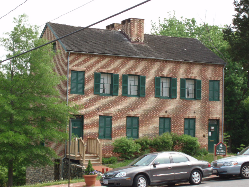
imagesize = 250px
image_caption = Laurel Museum, May 12, 2007
image_

mapsize = 250x200px
map_caption = Location of Laurel in Maryland
mapsize1 =
map_caption1 =
subdivision_type = Country
subdivision_type1 = State
subdivision_type2 = County
subdivision_name =United States
subdivision_name1 =Maryland
subdivision_name2 = Prince George's
government_type =
leader_title =Mayor
leader_name = Craig A. Moe
leader_title1 =City Council
leader_name1 = Ward 1: Janis L. Robison
Ward 1: Gayle Snyder
Ward 2: Frederick Smalls (Pr.)
Ward 2: Michael B. Sarich
At Large: Michael R. Leszcz
established_title = Incorporated
established_date = 1870
area_magnitude =
area_total_sq_mi = 3.8
area_total_km2 = 9.9
area_land_sq_mi = 3.8
area_land_km2 = 9.8
area_water_sq_mi = 0.04
area_water_km2 = 0.1
area_urban_sq_mi =
area_urban_km2 =
area_metro_sq_mi =
area_metro_km2 =
population_as_of = 2000
population_note =
population_total = 19,960
population_metro =
population_urban =
population_density_km2 = 2039
population_density_sq_mi = 5280.2
timezone = EST
utc_offset = -5
timezone_DST = EDT
utc_offset_DST = -4
latd = 39 |latm = 5 |lats = 45 |latNS = N
longd = 76 |longm = 51 |longs = 35 |longEW = W
elevation_m = 50
elevation_ft = 164
postal_code_type = ZIP codes
postal_code = 20707–20709, 20723–20729
area_code = 240, 301
website = [http://www.laurel.md.us/ www.laurel.md.us]
blank_name = FIPS code
blank_info = 24-45900
blank1_name = GNIS feature ID
blank1_info = 0597667
footnotes =Laurel is a
Maryland , U.S. city located midway betweenWashington, D.C. and Baltimore, in northern Prince George's County. Incorporated in 1870, the city maintains a historic district including itsMain Street . The official 2007 population estimate for Laurel city was 21,619; [cite web
url = http://factfinder.census.gov/servlet/DTTable?_bm=y&-context=dt&-ds_name=PEP_2007_EST&-mt_name=PEP_2007_EST_G2007_T001&-CONTEXT=dt&-tree_id=807&-all_geo_types=N&-geo_id=16000US2445900&-search_results=01000US&-format=&-_lang=en
title = Maryland by Place
accessdate = 2008-08-27
date =2007-07-01
work = 2007 Population Estimates
publisher = U.S. Census Bureau] adding the residents in Laurel's postal zip codes outsidecity limits , the population was 87,810 as of the 2000 census. [cite web |url=http://factfinder.census.gov/servlet/CTTable?_bm=y&-context=ct&-ds_name=DEC_2000_SF1_U&-mt_name=DEC_2000_SF1_U_P001&-tree_id=4001&-all_geo_types=N&-geo_id=86000US20707&-geo_id=86000US20708&-geo_id=86000US20723&-geo_id=86000US20724&-search_results=01000US&-dataitem=DEC_2000_SF1_U_P001.P001001&-format=&-_lang=en |title=Custom Table |accessdate=2007-09-27 |work=Census 2000 Summary File 1 (SF1) 100-Percent Data |publisher=U.S. Census Bureau ]Laurel is near Johns Hopkins University's
Applied Physics Laboratory , the Fort Meade Army base, and theNational Security Agency (NSA). It is also adjacent toLaurel Park Racecourse , a horse racetrack in Anne Arundel County.History
Pre-20th century
Laurel, Maryland was formed from land on the
fall line of thePatuxent River owned by the Snowden family, which also owned Montpelier. Agrist mill on the site circa 1811 grew to a smallcotton mill by the 1820s.cite web
url = http://www.stmarys.laurel.md.us/index.php?p=history
title = St Mary of the Mills Parish History
accessdate = 2007-07-21
last = Compton
first = Elizabeth L.
coauthors = Joanne Timchalk, Mary Mallonee, Lee Jacobs, Ron Jacobs, J.R. Compton, M.D.
year = 1993
publisher = St Mary of the Mills Parish] In 1835, coinciding with the opening of theCapital Subdivision rail line from Baltimore to Washington, the Patuxent Manufacturing Company was chartered and the mill expanded greatly. [cite web
url = http://www.anacostiatrails.org/site/media/ATHAnewsletterVol3No2.pdf
title = ATHA’s Featured Community: the City of Laurel
accessdate = 2007-07-21
last = Mills
first = Kristie
coauthors = Elsie Klumpner
date = Winter 2006
format = PDF
work = ATHA Newsletter, Vol. 3, No. 2
publisher = Anacostia Trails Heritage Area] Mill president Horace Capron with his partners built housing for close to 300 workers, and a bigger cotton mill.cite paper
first = Robert C
last = Chidester
title = A Historic Context for the Archaeology of Industrial Labor in the State of Maryland
publisher = Center for Heritage Resource Studies, Department of Anthropology, University of Maryland at College Park
url = http://www.heritage.umd.edu/CHRSWeb/AssociatedProjects/chidesterreport/Chapter%20VI.htm#_ftnref218
accessdate = 2007-07-21]Cotton duck from the mill was shipped down what would become Laurel’s Main Street then by rail to Baltimore. [cite web
url = http://www.laurelhistory.org/histsoc.html
title = Laurel Historical Society
accessdate = 2007-07-26
publisher = The Laurel Historical Society] A substantialdam was built in 1850. [cite web
url = http://www.mdhc.org/resources/ATHAReport_part4of6.pdf
title = The Changing Face of the Heritage Area in the Nineteenth Century
accessdate = 2007-07-21
last = Ridgway
first = Whitman H.
date =2003-02-13
format = PDF
work = Interpretive Plan for the Anacostia Trails Heritage Area
publisher = Maryland Humanities Council] As a mill town Laurel was somewhat unique in Prince George’s County, and was surrounded by agricultural endeavors.The community was originally known as Laurel Factory, and was a true company town, with a school, and shops, and many of the mill workers' homes owned until the 1860s by the company. During the 1840s three historic churches in the community: the Methodist, [cite web
url = http://fumcl.org/about/history.php
title = Our Church History
accessdate = 2007-07-26
publisher = First United Methodist Church of Laurel] St. Mary of the Mills (Roman Catholic), and St. Philip's (Episcopal) [cite web
url = http://www.stphilipslaurel.org/Profile.pdf
title = St. Philip's Parish History
accessdate = 2007-07-26
year = 2006
format = PDF
work = St. Philips Parish Profile
publisher = St. Philip's Episcopal Church
pages = 4] established what are still-vigorous congregations. During the Civil War, Laurel Factory, like much of Maryland, was a divided community, but with many Southern sympathizers. Union soldiers patrolled the railroad, and for a time there was also a Union hospital. During the latter half of the 19th Century, while it still operated its factories, manufacturing played a less important role in the community. Laurel evolved into an early suburban town. Many of its residents commuted by rail to jobs in Washington or Baltimore. The town was incorporated in 1870 and reincorporated in 1890 to coincide with a newelectric power plant and paved streets.Citizens National Bank opened its doors on Main Street in 1890 as Prince George's County's first nationally chartered
bank , and remained independently managed and with the same name until acquired byPNC Financial Services in 2007. [cite news
first = Liza
last = Gutherrez
title = PNC banks on new branches' community ties
url = http://www.gazette.net/stories/090607/busiplo154436_32356.shtml
publisher = The Laurel Gazette
pages = A-24 – 25
date =2007-09-06
accessdate = 2007-09-09 ] [cite news
first = Gwendolyn
last = Glenn
title = Display to honor bank's long history
url = http://news.mywebpal.com/news_tool_v2.cfm?pnpid=810&show=archivedetails&ArchiveID=1293808&om=1
publisher = Laurel Leader
pages =
date =2007-08-16
accessdate = 2007-09-09 ] Branch services are still provided from the original building.In 1899, Laurel's seven-time mayor Edward Phelps succeeded in constructing the first
high school inPrince George's County , despite several financial obstacles. The original building, now known as the Phelps Community Center, still stands at the northeast corner of Montgomery and Eighth Streets.20th century
Laurel hosted a horse trotter (
harness racing ) track namedFreestate Raceway from 1948 to 1990. [ [http://www.highbeam.com/doc/1P2-1210279.html "Freestate Raceway Is Sold for Planned Industrial Park"] , HighBeam Research Inc., partial text of "Washington Post" article from September 6, 1989. "URL retrieved on November 27, 2006".] [ [http://www.highbeam.com/doc/1P2-1108090.html "It's Final: Freestate Is No More; Commission Grants Request to Transfer '90 Dates to Rosecroft"] , HighBeam Research Inc., partial text of "Washington Post" article from January 31, 1990. "URL retrieved on November 27, 2006".] It was located in Howard County on the west side of US Route 1, south of Savage in an area that now includes aCarMax dealership, Weis supermarket, andstrip mall .On May 15, 1972, Governor
George Wallace ofAlabama , running for the presidential nomination of the Democratic Party, was campaigning at a rally in the parking lot ofLaurel Shopping Center , near what is today aBank of America branch, when he was shot and paralyzed byArthur Bremer , a disturbed, out-of-work janitor (see "An Assassin's Diary ").On June 22, 1972 Laurel was impacted severely by
Hurricane Agnes , which caused the greatestflood ing ever recorded in Maryland. [ [http://md.water.usgs.gov/publications/wsp-2375/md-dc/md-dc-html.html "USGS Water Supply Paper 2375 National Water Summary, Maryland and the District of Columbia Floods and Droughts"] . "URL retrieved on November 27, 2006".] Severalbridge s were destroyed and the nearby T. Howard DuckettDam at Rocky Gorge Reservoir was at capacity and posed a huge threat. [ [http://www.mafsm.org/pdf/06_RegForm.pdf Invitation] to the Maryland Association of Floodplain and Stormwater Managers Second Annual Conference and General Membership Meeting, October 18-19, 2006. "URL retrieved on November 27, 2006".]A former 1840s mill workers' home on the northeast corner of 9th and Main Streets was renovated and opened as the
Laurel Museum on May 1, 1996. The museum features exhibits that highlight the history of Laurel and its citizens. A gift shop is available and museum admission is free. The museum'sJohn Calder Brennan Library is open to researchers by appointment. [ [http://www.laurelhistory.org/museum.html Laurel Museum] , Laurel Historical Society. "URL retrieved on November 28, 2006".]21st century
On September 24, 2001, a
tornado passed through Laurel and left F3 property damage, including significant roof damage to Laurel High School and the historic Harrison-Beard Building. [cite web
url=http://www.baltimoresun.com/news/local/bal-te.md.laurel26sep26,0,1440758.story?coll=bal-local-utility
title=Laurel sustains millions in damages
accessdate=2007-06-18
last=Bykowicz
first=Julie
coauthors=Larry Carson
date=2001-09-26
publisher="The Baltimore Sun"]Prior to the
September 11, 2001 attacks , some of the hijackers stayed atmotel s in the Laurel area, including the Budget Host Valencia and Pin-Del motels in Howard County just north of the city limits. The wing of the Valencia where they stayed was demolished and a new Sleep Inn was constructed on the ground, which opened in April 2007. They accessed theInternet through public computers at a Kinko's just south of the city limits, and visited aGold's Gym in neighboring Anne Arundel County with short-term passes. [Robert S. Mueller III ,FBI Director. [http://www.fas.org/irp/congress/2002_hr/092602mueller.html "Statement for the Record"] , Joint Intelligence Committee Inquiry. September 26, 2002. "URL retrieved on December 22, 2006".] [Thomas Frank, [http://web.archive.org/web/20020405020924/http://www.newsday.com/ny-usflight232380680sep23.story "Tracing Trail of Hijackers"] , "Newsday", April 4, 2002. "URL retrieved on December 22, 2006".]On August 29, 2005, Laurel adopted
Laurel, Mississippi as asister city to help withHurricane Katrina relief and recovery. [cite web
url = http://www.laurel.md.us/citizen_nov2006.htm
title = Citizen and Student of the Month
accessdate = 2007-09-08
month = November
year = 2006
publisher = City Council of Laurel, Maryland] In the two years following adoption, "the government, businesses and residents of Laurel, Md. ... raised more than $20,000 for Laurel, Miss." [cite news
first = Steve
last = Early
title = Laurel namesake recovers from Hurricane Katrina
url = http://www.gazette.net/stories/090607/laurnew121344_32364.shtml
publisher = The Gazette (Laurel edition)
page = A-9
date = 2007-09-06
accessdate = 2007-09-08 ]Geography
Laurel is located at coor dms|39|5|45|N|76|51|35|W|region:US-MD_type:city(20,000)_scale:30000. This positions it on the bank of the
Patuxent River , which was the power source for thecotton mill s that were the early industry of the town.Though the incorporated portion of Laurel is bounded entirely within the northern tip of
Prince George's County , the larger area generally known by s as Laurel spreads eastward into Anne Arundel County, northward into Howard County, and west toward (though not into) Montgomery County.The
ZIP Code s for the community of Laurel are 20707 through 20709 and 20723 through 20729. Although served by the Laurel post office, Montpelier is not within thecity limits ; the same is true for the unincorporated communities of Scaggsville and Whiskey Bottom in Howard County, and Maryland City and Russett in Anne Arundel County.Demographics
As of the
census GR|2 of 2000, there were 19,960 people, 8,931households , and 4,635 families residing in the city. Thepopulation density was 5,280.2 people per square mile (2,038.8/km²). There were 9,506 housing units at an average density of 2,514.7/sq mi (971.0/km²). The racial makeup of the city was 52.24% White, 34.50% African American, 0.38% Native American, 6.89% Asian, 0.21% Pacific Islander, 2.30% from other races, and 3.47% from two or more races. Hispanic or Latino of any race were 6.24% of the population.There are 8,931 households, of which 26.7% have children under the age of 18, 33.9% were married couples living together, 13.3% had a
female householder with no husband present, and 48.1% were non-families. 37.4% of all households were made up of individuals and 5.2% had someone living alone who was 65 years of age or older. The average household size was 2.22 and the average family size was 2.97.In the city the
population was spread out with 22.0% under the age of 18, 8.6% from 18 to 24, 42.9% from 25 to 44, 19.7% from 45 to 64, and 6.7% who were 65 years of age or older. The median age was 34 years. For every 100 females there were 93.2males . For every 100 females age 18 and over, there were 90.3 males.The median income for a household in the city was $49,415, and the median income for a family was $58,552. Males had a median income of $37,966 versus $35,614 for females. The
per capita income for the city was $26,717. About 4.3% of families and 6.4% of the population were below thepoverty line , including 7.8% of those under age 18 and 6.4% of those age 65 or over.For statistical reporting, the Census Bureau identifies four adjacent unincorporated areas:
* West Laurel (upper west)
* North Laurel
* Maryland City (to the east)
* South LaurelTransportation
Laurel is traversed from north to south by U.S. 1, which links
Key West, Florida with theCanadian border inMaine . On the west the city is bordered by Interstate 95, and beyond the eastern border lies theBaltimore-Washington Parkway . Crossing all of these highways is the east-west artery ofMaryland Route 198 , which intersects with U.S. 1 in the heart of Laurel.Other major state roads in Laurel are
Maryland Route 216 , which connects the city with southern Howard County, andMaryland Route 197 , which runs from Laurel to Bowie. The eastern terminus ofMaryland Route 200 (the Intercounty Connector) will lie just south of the city limits, should the proposedhighway between Laurel andGaithersburg, Maryland be completed.Suburban Airport , a one-stripgeneral aviation facility, is located off of Maryland Route 197, just over the Anne Arundel County border.Baltimore-Washington International Thurgood Marshall Airport andRonald Reagan Washington National Airport are both within about 25 miles of Laurel.;Public TransportTwo MARC train stations on the Camden Line to Baltimore and Washington, D.C. are located in Laurel: Laurel Station and Laurel Racetrack Station, the latter with minimal service. Laurel Station is a particularly notable example of the stations designed by E. Francis Baldwin for the
Baltimore and Ohio Railroad .The
Washington Metropolitan Area Transit Authority (WMATA) Metrobus service provides four lines into Laurel, and localConnect-a-Ride andHoward Transit bus service is available. Severaltaxicab and shuttle services also support the region.Emergency services
The Laurel Police Department is part of the Sixth District of the
Prince George's County Police Department . TheMaryland State Police patrol Route 1, Route 198, and Interstate 95, which pass through the area, and theUnited States Park Police patrol theBaltimore-Washington Parkway and its connectors.The primary emergency services providers for the City of Laurel and surrounding parts of Prince George’s County are the Laurel Volunteer Fire Department (Company 10) and the Laurel Volunteer Rescue Squad (Company 49). Both companies are part of the Prince George’s County Fire/EMS Department.
The Laurel Volunteer
Fire Department was formed in 1902. Today the department is located at 7411 Cherry Lane. Volunteer staffing is supplemented by five career personnel from 7:00am to 3:00pm Monday through Friday excluding holidays. The company operates three fire engines (Engine 101, Engine 103, and Engine 104); and an aerial tower (Tower 10).Ambulance service began December 11, 2006. As of June 2008, two ambulances are operated out of the Laurel fire station (Ambulance 108 and Ambulance 109). The City of Laurel Emergency Command Unit is also located at the station.The Laurel Volunteer
Rescue Squad was formed in 1952. Today the department is located at 14910 Bowie Road. Volunteer staffing is supplemented by four career personnel from 7:00am to 3:00pm Monday through Friday excluding holidays. The company operates one heavy rescue squad, one rescue-engine, three basic life support ambulances, and aswiftwater rescue team. Aparamedic unit staffed by career personnel is also assigned to Company 49.Laurel Regional
Hospital , managed by Dimensions Health Corporation, is located on Van Dusen Road.Municipal government
Laurel is governed by a 5-member city council and a
mayor . There are two political wards in the city. The first ward is generally the area north of Maryland Route 198 and the second ward is to the south. [cite web
url = http://www.laurel.md.us/voteward.htm
title = Laurel Voting Wards
accessdate = 2007-07-15
publisher = City of Laurel, Maryland] Two council members are elected from each ward, and a council member is elected at large. Residents vote for all five council members, who must reside in Laurel a year before their election and during their full term of office.Nonpartisan city-wide elections are held every two years at Phelps Senior Center on the corner of Montgomery Street and 8th Street/St. Mary's Place. [cite web |url=http://www.laurel.md.us/cc.htm |title=City Council of Laurel, Maryland |accessdate=2008-04-22 |publisher=City of Laurel, Maryland ] The next election, to select a mayor and city council members, will be held in 2010.The council elects one of its members to serve as
president . The president of the city council presides over council meetings and can act in a limited capacity as mayor if the mayor is unavailable. Council members serve for two years each term; the mayor serves for four years.Media and culture
Stanley Memorial Library , the Laurel branch of the Prince George's County MemorialLibrary System, is located at the intersection of Seventh Street and Talbott Avenue. The "Maryland City at Russett" branch of the Anne Arundel County Public Library is also available to Laurel residents.Media
Television arrived in Laurel with the establishment of the first TV broadcast stations in Washington in 1946. For decades, Laurel has been served by theVHF TV channels 4, 5, 7, and 9 from Washington, and channels 2, 11, and 13 from Baltimore. In addition, there are dozens ofUHF TV stations from Washington, Baltimore, and Annapolis. From these three cities, scores of AM and FMradio stations reach Laurel.There are two local newspapers: [http://www.laurelleader.com "Laurel Leader"] and "The Laurel Gazette". In addition, there is one
mediumwave AM radio station,WILC ("Viva 900") serving the Hispanic community.With its location between Washington and Baltimore, Laurel is also served by their daily newspapers "
The Washington Post ", "The Washington Times " and "The Baltimore Sun ". Many Laurel residents also read a freenewspaper , the "Washington Examiner ".In the book, Seabiscuit: An American Legend, Laurel is mentioned several times as an important horse racing venue.
Arts
Laurel's
movie theater , the Laurel Cinema 6, shows first-run American movies andBollywood movies. Localperforming arts outlets include the [http://www.laurelmillplayhouse.org Laurel Mill Playhouse] , [http://www.centralmarylandchorale.com/ Central Maryland Chorale] (formerly Laurel Oratorio Society) and [http://www.pgparks.com/places/artsfac/mac.html Montpelier Arts Center] , which also features anart gallery . Another local exhibitor is the [http://www.wssc.dst.md.us/info/gallery/ WSSC Art Gallery] .Events
The city government supports an annual LakeFest in May and
Independence Day celebration each July. Since 1981, the Laurel Board of Trade has sponsored a Main Street Festival (held on Saturday of Mother's Day weekend) each May, and since 1995 a RiverFest each October. The Montpelier Mansion grounds have hosted an annual festival the first weekend in May since 1971, updated in 2007 to focus on an "herb, tea and arts" theme. [Garnes, Kathy. "Montpelier herb, tea and art fest moves to May". "Laurel Leader". Patuxent Publishing Co.April 19 2007 .]Laurel in popular culture
There is a line in the novel "The Dead Zone" by
Stephen King , consisting of "Laurel, Maryland" repeated over and over. Presumably this represents a psychic allusion to the attempted assassination of George Wallace in 1972.In addition, in
Tom Clancy 's novel "The Cardinal of the Kremlin ", an FBI agent pretending to work for DARPA comments to her target, a Soviet mole, "This is so much nicer than living in Laurel!"X-Files episode, "Talitha Cumi", references a street in West Laurel when Mulder says, "Off the I-95, uh Bond Mill Road," while designating a location to meet with Scully.Famous people
Future President and Mrs.
Dwight D. Eisenhower and their first son (Doud Dwight, about 5 months old) lived at Mrs. Ray's Boarding House at 327 Montgomery Street and Halverson's Boarding House in Laurel in March 1918 during the couple's second year of marriage. [ [http://www.eisenhower.archives.gov/quick_links/eisenhower_FAQ/Eisenhower.residences.html "Residences of General and Mrs. Eisenhower"] . Dwight D. Eisenhower Presidential Library. "URL retrieved onDecember 20 ,2006 ".]Hall of Fame race horse
jockey Ron Turcotte trained at Laurel Park race course in the late 1960s.Rap artist
Biz Markie moved to Laurel in 1996. [Morris, Mary. [http://remixmag.com/mag/remix_biz_markie/ "Biz Markie"] . Remix.February 1 ,2004 . "URL retrieved onJanuary 9 ,2007 ".]Former
Megadeth lead guitarist Marty Friedman attended Laurel High School in the 1970s. [ [http://www.martyfriedman.com/fans_faq_content.php?id=584 "West Laurel barn razing"] . October 2002. Fan Questions and Answers. Marty Friedman Official Website. "URL retrieved onDecember 20 ,2006 ".]Education
Primary and secondary schools
Public schools within city limits
Prince George's County Public Schools serves residents within Laurel's city limits.City residents are zoned to Laurel Elementary School or Scotchtown Hills Elementary School, both within the city limits.
Two public middle schools in the Laurel area, Dwight D. Eisenhower and Martin Luther King Jr. Middle Schools in Prince George's County, serve the actual city of Laurel.
Laurel High School serves the city of Laurel.
Public schools nearby
Nearby elementary schools serving areas outside of the Laurel city limits include Bond Mill, Deerfield Run, James H. Harrison, Montpelier, Oaklands, and Scotchtown Hills Elementary Schools in Prince George's County; Brock Bridge and Maryland City Elementary Schools in Anne Arundel County; and Forest Ridge, Gorman, Hammond, and Laurel Woods Elementary Schools in Howard County.
Areas near Laurel in adjacent counties are served by MacArthur and Meade Middle Schools in Anne Arundel County and Hammond and Murray Hill Middle Schools in Howard County.
Other public high schools which serve the adjacent areas outside Prince George's County include Meade High School in Anne Arundel County and Atholton, Hammond and
Reservoir High School s in Howard County. A notablemagnet school in Prince George's County is Eleanor Roosevelt High School.District of Columbia alternative school
District of Columbia Public Schools operates an alternative middle and high school near Laurel called [http://www.k12.dc.us/schools/oakhill/ Oak Hill Academy] .Private schools
*Faith Baptist Christian School –
Pre-K through grade 8
*First Baptist School of Laurel – Pre-K through grade 8
*Julia Brown Montesorri School – Pre-K through grade 3
*Kiddie Academy of Laurel – for ages 6 weeks through 12 years
*Kiddies Kollege Christian Center – for ages 2 years through 5 years
*Laurel Baptist Academy –kindergarten through grade 12
*Pallotti Day Care Center –Catholic kindergarten
*St. Mary of the Mills School – Catholic kindergarten through grade 8
*St. Vincent Pallotti High School – Catholic high schoolColleges, universities, and trade schools
Prince George's Community College andHoward Community College share a campus in Laurel called the Laurel College Center. [cite web
url = http://www.laurelcollegecenter.org/
title = Laurel College Center Home Page
accessdate = 2007-07-20
publisher = Laurel College Center]Capitol College is located south of Laurel.The Anne Arundel County section of Laurel hosts the Woodland
Job Corps Center.ports and recreation
Laurel's Department of Parks & Recreation sponsors seasonal sports leagues for adults, with youth leagues in the area offered by the Laurel
Boys and Girls Club . [ [http://laurel.md.us/sportsprog.htm "Sports Programs"] , Department of Parks & Recreation, City of Laurel. "URL retrieved onDecember 22 ,2006 ".] Events are held among eleven city parks, three athletic fields, and threecommunity center s. The city also operates a municipalswimming pool andtennis court s. [ [http://laurel.md.us/prfac.htm "Parks & Facilities Tour"] , Department of Parks & Recreation, City of Laurel. "URL retrieved onDecember 22 ,2006 ".] Four indoor facilities and seven outdoor facilities are available for private rental. [ [http://laurel.md.us/prfees.htm "Facility Rentals"] , Department of Parks & Recreation, City of Laurel. "URL retrieved onDecember 22 ,2006 ".]The Fairland Sports and Athletic Complex on the grounds of the Fairland Regional Park, southwest of the city limits, is operated by the
Maryland-National Capital Park and Planning Commission . These facilities offer a broad variety of activities including swimming,gymnastics , tennis,racquetball ,weight training , child sitting, andmassage therapy. [ [http://www.pgparks.com/places/sportsfac/specialized.html "M-NCPPC Specialized Sports Facilities"] , Department of Parks & Recreation, Prince George's County Maryland. "URL retrieved onDecember 22 ,2006 ".]Also located within Fairland Regional Park, The Gardens Ice House skating facility offers three rinks for
ice skating lessons, public skating,figure skating ,hockey ,speed skating , andcurling . Recent additional activities includebasketball andlacrosse . [ [http://www.thegardensicehouse.com/ The Gardens Ice House] , Laurel, Maryland. "URL retrieved onDecember 22 ,2006 ".]The Laurel Roller Skating Center, just north of the city limits, provides a location for public
roller skating . [Lane, Raymond M. [http://washingtontimes.com/weekend/20040224-102240-4100r.htm "Getting up to speed on roller skating fun"] , "The Washington Times",February 26 ,2004 . "URL retrieved onDecember 22 ,2006 ".]ee also
Laurel Mall References
External links
* [http://www.laurel.md.us/ Official Website: City of Laurel, Maryland]
* [http://www.laurel.md.us/hist.htm History of the City of Laurel, Maryland]
* [http://www.laurelboysandgirlsclub.org Laurel Boys and Girls Club]
*

Wikimedia Foundation. 2010.