- Barton, Maryland
Infobox Settlement
official_name = Barton, Maryland
settlement_type =Town
nickname =
motto =
imagesize =
image_caption =
image_
imagesize =
image_caption =
image_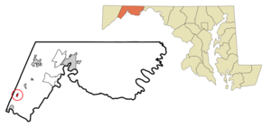
mapsize = 250x200px
map_caption = Location of Barton, Maryland
mapsize1 =
map_caption1 =subdivision_type = Country
subdivision_name =United States
subdivision_type1 = State
subdivision_name1 =Maryland
subdivision_type2 = County
subdivision_name2 = Allegany
government_footnotes =
government_type =
leader_title =
leader_name =
leader_title1 =
leader_name1 =
established_title =
established_date =unit_pref = Imperial
area_footnotes =area_magnitude =
area_total_km2 = 0.6
area_land_km2 = 0.6
area_water_km2 = 0.0
area_total_sq_mi = 0.2
area_land_sq_mi = 0.2
area_water_sq_mi = 0.0population_as_of = 2000
population_footnotes =
population_total = 478
population_density_km2 = 822.3
population_density_sq_mi = 2129.8timezone = Eastern (EST)
utc_offset = -5
timezone_DST = EDT
utc_offset_DST = -4
elevation_footnotes =
elevation_m = 377
elevation_ft = 1237
latd = 39 |latm = 31 |lats = 54 |latNS = N
longd = 79 |longm = 1 |longs = 1 |longEW = Wpostal_code_type =
ZIP code
postal_code = 21521
area_code = 301
blank_name = FIPS code
blank_info = 24-04625
blank1_name = GNIS feature ID
blank1_info = 0583047
website =
footnotes =Barton is a town in
Allegany County, Maryland ,United States , located along theGeorges Creek Valley . It is part of the Cumberland, MD-WV Metropolitan Statistical Area. The population was 478 at the 2000 census.Barton has four churches and many volunteer groups. There is a lighted ball field, a playground, and two parks for use by citizens. Barton has survived floods and fires and still maintains its peaceful and congenial atmosphere. Each year the town celebrates itself with a Party in the Park. That get-together showcases crafts, food, entertainment, and a parade through the center of town.
History
The Reverend William Shaw, a
Methodist minister settled on the site of Barton in1794 . His son, William Shaw Jr. laid out the town in 1853, naming it for his father's hometown,Barton-upon-Humber ,England .The discovery of coal in the area attracted more settlers. They came from Scotland, Ireland, and Germany, eager to work in the mines. In 1853, the first shipment of coal was made on the newly built Chesapeake and Potomac Railroad. Eventually, all the deep coal mines had been abandoned and replaced by strip mines, several of which are still in operation and can be seen from the town. Today, most families in Barton are supported by other types of employment.
The town's first
Gristmill was located at the confluence ofMoores Run andGeorges Creek .Nearby communities
1.
Cumberland, Maryland
2.Lonaconing, Maryland
3.Westernport, Maryland
4.Piedmont, West Virginia
5.Luke, Maryland
6.Midland, Maryland
7.Keyser, West Virginia
8.Frostburg, Maryland
9.Cresaptown-Bel Air, Maryland Geography
Barton is located at coor dms|39|31|54|N|79|1|1|W|city (39.531693, -79.017077)GR|1.
According to the
United States Census Bureau , the town has a total area of 0.2square mile s (0.6km² ), all of it land.Demographics
As of the
census GR|2 of 2000, there were 478 people, 200 households, and 142 families residing in the town. Thepopulation density was 2,129.8 people per square mile (838.9/km²). There were 233 housing units at an average density of 1,038.2/sq mi (408.9/km²). The racial makeup of the town was 99.58% White and 0.42% African American.There were 200 households out of which 28.5% had children under the age of 18 living with them, 55.5% were married couples living together, 11.0% had a female householder with no husband present, and 29.0% were non-families. 27.5% of all households were made up of individuals and 16.5% had someone living alone who was 65 years of age or older. The average household size was 2.39 and the average family size was 2.89.
In the town the population was spread out with 23.2% under the age of 18, 8.8% from 18 to 24, 25.5% from 25 to 44, 24.5% from 45 to 64, and 18.0% who were 65 years of age or older. The median age was 39 years. For every 100 females there were 98.3 males. For every 100 females age 18 and over, there were 88.2 males.
The median income for a household in the town was $30,104, and the median income for a family was $33,333. Males had a median income of $29,844 versus $14,196 for females. The
per capita income for the town was $14,453. About 13.1% of families and 14.4% of the population were below thepoverty line , including 32.7% of those under age 18 and 8.4% of those age 65 or over.ee also
*
Georges Creek Valley
*References
External links
* [http://www.whilbr.org/barton/index.aspx Barton, Allegany County, Store Ledger 1895-1897] from Western Maryland Public Libraries
Wikimedia Foundation. 2010.