- York Harbor, Maine
Infobox Settlement
official_name = York Harbor, Maine
settlement_type = CDP
nickname =
motto =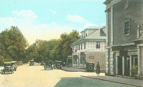
image_caption = York Street and The Lancaster Building, c. 1922
imagesize =
image_|pushpin_
pushpin_label_position =left
pushpin_map_caption =Location within the state of Maine
pushpin_mapsize =
|mapsize =
map_caption =
mapsize1 =
map_caption1 =subdivision_type = Country
subdivision_name =United States
subdivision_type1 = State
subdivision_name1 =Maine
subdivision_type2 = County
subdivision_name2 = York
government_footnotes =
government_type =
leader_title =
leader_name =
leader_title1 =
leader_name1 =
established_title =
established_date =unit_pref = Imperial
area_footnotes =area_magnitude =
area_total_km2 = 9.1
area_land_km2 = 8.3
area_water_km2 = 0.7
area_total_sq_mi = 3.5
area_land_sq_mi = 3.2
area_water_sq_mi = 0.3population_as_of = 2000
population_footnotes =
population_total = 3321
population_density_km2 = 399.9
population_density_sq_mi = 1035.6timezone = Eastern (EST)
utc_offset = -5
timezone_DST = EDT
utc_offset_DST = -4
elevation_footnotes =
elevation_m = 14
elevation_ft = 46
latd = 43 |latm = 8 |lats = 33 |latNS = N
longd = 70 |longm = 38 |longs = 50 |longEW = Wpostal_code_type =
ZIP code s
postal_code = 03910-03911
area_code = 207
blank_name = FIPS code
blank_info = 23-88160
blank1_name = GNIS feature ID
blank1_info = 0578771
website =
footnotes =York Harbor is a
census-designated place (CDP) in the town of York in York County,Maine ,United States . The population was 3,321 at the 2000 census. York Harbor is a distinguished formerGilded Age summer colony noted for its resort architecture. It is part of the Portland–South Portland–Biddeford, Maine Metropolitan Statistical Area.History
York was a prosperous
seaport in the 18th-century. Its harbor, then known as Lower Town, was lined with wharves andwarehouse s to which upriver settlers brought their goods for trade and shipping. The tongue of land at the mouth of the York River was called Gallows Point, where criminals at the Royal Gaol in York Village were hanged. At high tide the tongue became an island, from which aferry licensed in 1652 crossed to Seabury.During the Revolution, fishermen and their families abandoned the
Isles of Shoals off the coast and floated their homes to the Lower Town waterfront, where they were rebuilt. They hauled their boats at Lobster Cove and dried their catch on fish flakes, after which the tongue would be named Stage Neck. In 1807, President Thomas Jefferson's embargo crippled local mercantile trade, and by the Civil War, Stage Neck had deteriorated into a ramshackleslum .After the rebellion, Nathaniel Grant Marshall (1812-1882), a lawyer, had a vision to convert the poorest section of Lower Town into a first-class summer
emporium for wealthy tourists. He bought Stage Neck, razed the fishermen's shacks and in 1871 built a grand hotel called The Marshall House. As part of its upgrade, Lower Town was renamed York Harbor. Coastal steamers began arriving with families drawn to the Maine shore from the heat and pollution in Boston, New York, Chicago, Philadelphia and Baltimore. Many liked the area enough to build summer mansions, characteristically in theShingle Style during the 1880-1890 boom. Soon York Harbor joined Bar Harbor and Newport as fashionable East Coast summer destinations.Competing hotels were built, including Harmon Hall and The Hotel Albracca. But The Marshall House was the largest, accommodating 325 guests by 1900. It offered
telephone andtelegraph offices, alivery stable , riding andbathing facilities,tennis court s,barbershop ,billiards room,ballroom ,sailing , fishing excursions andcanoe s for picnics up the York River. The Marshalls started both an electric and water company, and headed the effort to build the York Harbor & Beach Railroad, opened in 1887.When The Marshall House burned in 1916, it was rebuilt in fire-resistant brick the following year to designs by noted Portland architect
John Calvin Stevens . It resumed its role as the center of York Harbor social life. At itsporte cochere , chauffeur-drivenlimosine s from the estates deposited their owners inevening gown s andtuxedo es, to be joined by hotel patrons for dinner at 7:30 p.m. Post-prandial entertainments includedchamber music by a Boston Symphony ensemble in the lobby, or Saturday dancing and costume parties in the ballroom.But a rift grew between York Harbor and York Beach further up the coast, which catered to the less affluent. The former disapproved of the latter's "cottage and campground philosophy," and tried to prevent the
trolley connecting the two. In 1908, York Harbor proposedsecession from York, first as a new town called Yorktown, then as Gorges after Sir Ferdinando Gorges, the early proprietor of Maine. Because the split would have deprived remaining York of much of real value within the community, including the town hall, it failed and The Yorks reconciled.Development here began in the 1870s and virtually ended in the 1920s, leaving York Harbor a
microcosm of period resort architecture, now converted for year-round use. The Marshall House was sold in 1957 and demolished in 1972, to be replaced with condominiums and [http://www.StageNeck.com The Stage Neck Inn] (designed by Sasaki, Dawson, DeMay Associates). However, the York community retains a wealth ofSecond Empire , Shingle Style,Mission Revival andColonial Revival architecture. Of particular note are The Lancaster Building designed by E. B. Blaisdell and built in 1895, Trinity Episcopal Church designed by H. J. Hardenbergh and built in 1908, and The York Harbor Reading Room designed by James Purdon and built in 1910. The Cliff Walk, an ancient shoreline path lined with beach roses, winds toward Eastern Point along ledges above the surf.Geography
York Harbor is located at coor dms|43|8|33|N|70|38|50|W|city (43.142573, -70.647106).GR|1
According to the
United States Census Bureau , the CDP has a total area of 3.5square mile s (9.0km² ), of which, 3.2 square miles (8.3 km²) of it is land and 0.3 square miles (0.8 km²) of it (8.31%) is water. Located beside theGulf of Maine andAtlantic Ocean , York Harbor is drained by the York River.Demographics
As of the
census GR|2 of 2000, there were 3,321 people, 1,334 households, and 895 families residing in the CDP. Thepopulation density was 1,035.6 people per square mile (399.5/km²). There were 1,601 housing units at an average density of 499.3/sq mi (192.6/km²). The racial makeup of the CDP was 98.13% White, 0.12% African American, 0.06% Native American, 0.57% Asian, 0.21% from other races, and 0.90% from two or more races. Hispanic or Latino of any race were 0.63% of the population.There were 1,334 households out of which 28.1% had children under the age of 18 living with them, 58.5% were married couples living together, 6.9% had a female householder with no husband present, and 32.9% were non-families. 28.3% of all households were made up of individuals and 13.3% had someone living alone who was 65 years of age or older. The average household size was 2.35 and the average family size was 2.88.
In the CDP the population was spread out with 21.9% under the age of 18, 4.2% from 18 to 24, 22.5% from 25 to 44, 27.7% from 45 to 64, and 23.7% who were 65 years of age or older. The median age was 46 years. For every 100 females there were 81.8 males. For every 100 females age 18 and over, there were 78.9 males.
The median income for a household in the CDP was $53,969, and the median income for a family was $71,164. Males had a median income of $49,706 versus $30,850 for females. The
per capita income for the CDP was $29,016. About 1.0% of families and 5.3% of the population were below thepoverty line , including 2.4% of those under age 18 and 11.9% of those age 65 or over.References
Further reading
* John D. Bardwell, "A History of York Harbor & The York Harbor Reading Room", 1993; Old York Historical Society; Peter E. Randall, publisher; Portsmouth, New Hampshire
* Virginia S. Spiller (editor), "350 Years as York", 2001; published by the Town of York 350th Committee; York, MaineExternal links
* [http://www.yorkmaine.org/ Town of York, Maine]
* [http://www.oldyork.org/ Old York Historical Society]
* [http://www.york.lib.me.us/ York Public Library]
* [http://www.aycsail.org/ Agamenticus Yacht Club]
* [http://www.yorkharborreading.com/ The York Harbor Reading Room]

Wikimedia Foundation. 2010.