- Mexico, Allegany County, Maryland
-
Mexico — Unincorporated community, — Location within the state of Maryland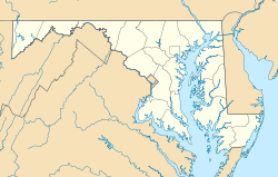

Coordinates: 39°36′13″N 78°44′34″W / 39.60361°N 78.74278°WCoordinates: 39°36′13″N 78°44′34″W / 39.60361°N 78.74278°W Country United States State Maryland County Allegany Elevation 604 ft (184 m) Time zone Eastern (EST) (UTC-5) - Summer (DST) EDT (UTC-4) ZIP codes FIPS code GNIS feature ID 1713487 Mexico is an unincorporated community, in Allegany County, Maryland. It lies at an elevation of 604 feet (184 m).[1]
References
Municipalities and communities of Allegany County, Maryland County seat: Cumberland Cities 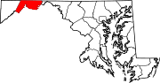
Towns Barton | Lonaconing | Luke | Midland | Westernport
CDPs Other
communitiesAmcelle | Barrelville | Bel Air | Bellegrove | Bier | Borden Shaft | Bowling Green | Carlos | Clarysville | Corriganville | Cresaptown | Danville | Dawson | Detmold | Dickens | Eckhart Mines | Ellerslie | Evitts Creek | Flintstone | Franklin | George's Creek | Klondike | Little Orleans | McCoole | McKenzie | Mexico | Midlothian | Moscow | Mount Savage | Narrows Park | Nikep | North Branch | Oldtown | Pekin | Pinto | Pleasant Valley | Potomac Park | Rawlings | Spring Gap | Town Creek | Vale Summit | Woodland | Zihlman
Categories:- Unincorporated communities in Maryland
- Populated places in Allegany County, Maryland
- Maryland geography stubs


Wikimedia Foundation. 2010.