- Maryland Route 55
-
Maryland Route 55
Vale Summit Road 
Route information Maintained by MDSHA Length: 2.53 mi[1] (4.07 km) Major junctions South end:  MD 36 in Vale Summit
North end: 
 US 40 Alt. in Clarysville
Location Counties: Allegany Highway system Maryland highway system
Interstate • US • State • Minor • Former • Turnpikes←  MD 54
MD 54MD 56  →
→Maryland Route 55 (MD 55) is a state highway in the U.S. state of Maryland. Known as Vale Summit Road, the state highway runs 2.53 miles (4.07 km) from MD 36 in Vale Summit north to U.S. Route 40 Alternate (US 40 Alternate) in Clarysville. MD 55 connects the La Vale area with Midland in the upper Georges Creek Valley in northwestern Allegany County. MD 55 was paved from Clarysville to Vale Summit around 1921 and extended south to Midland in the late 1930s. The state highway was truncated at Vale Summit when MD 36 took over part of the highway for a new alignment in the early 1970s.
Contents
Route description
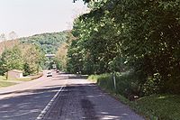 MD 55 south of Clarysville
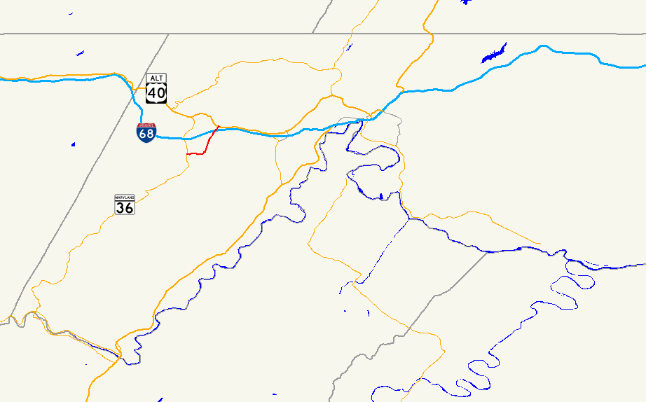
MD 55 begins at an intersection with MD 36 (New Georges Creek Road) in Vale Summit. The two-lane highway descends from Vale Summit into the valley of Braddock Run on its way to Clarysville. The state highway starts by heading east through a residential area of Vale Summit.[1][2] As MD 55 passes the Vale Summit United Methodist Church, which dates back to 1889, the state highway curves to the north and passes by the residential settlements of Loartown and Montel.[1][2][3] The state highway descends into Spruce Hollow and passes under Interstate 68 and US 40 (National Freeway) with no access before arriving in Clarysville.[1][2] MD 55 intersects Clarysville Road, the original alignment of US 40, and passes the site of the Clarysville Inn, a historic inn built in 1807 that was destroyed by a fire in 1999, before reaching its northern terminus at US 40 Alternate (National Pike) in Clarysville.[1][2][4]
History
MD 55 was paved from Clarysville to Vale Summit by 1921.[5] The Vale Summit–Midland segment of the highway was constructed around 1938.[6] When US 40 was relocated in Clarysville around 1950, MD 55 was extended north a short distance to meet the new alignment.[7] MD 55 itself was rebuilt and widened from Clarysville to Vale Summit in 1952 and from there to Midland in 1954.[8] As part of MD 36's relocation between Midland and Frostburg, MD 36 took over the section of MD 55 between Midland and Vale Summit in 1972, leaving MD 55 at its present length.[9]
Junction list
The entire route is in Allegany County.
Location Mile[1] Destinations Notes Vale Summit 0.00 MD 36 (New Georges Creek Road) – Midland, FrostburgSouthern terminus Clarysville 2.53
US 40 Alt. (National Pike) – Cumberland, FrostburgNorthern terminus 1.000 mi = 1.609 km; 1.000 km = 0.621 mi References
- ^ a b c d e f "Highway Location Reference: Allegany County" (PDF). Maryland State Highway Administration. 2009. http://www.marylandroads.com/Location/2009_ALLEGANY.pdf. Retrieved 2010-10-21.
- ^ a b c d Google, Inc. Google Maps – Maryland Route 55 (Map). Cartography by Google, Inc. http://maps.google.com/maps?f=d&source=s_d&saddr=MD+36+and+MD+55+vale+summit,+md&daddr=National+Highway+and+MD+55+clarysville,+md&hl=en&geocode=&mra=ls&sll=39.630746,-78.894539&sspn=0.029218,0.054932&ie=UTF8&ll=39.631407,-78.902006&spn=0.029218,0.054932&t=h&z=14. Retrieved 2009-06-15.
- ^ "Highlights of the Appalachian Collection". Allegany College of Maryland. http://www.allegany.edu/library/aplhig.shtml. Retrieved 2009-07-20.
- ^ Askey, Carol. "The Historic Clarysville Inn - A Tribute". RootsWeb. http://www.rootsweb.ancestry.com/~mdallegh/Photos-old/claryinn.htm. Retrieved 2009-07-20.
- ^ Maryland Geological Survey. Map of Maryland: Showing State Road System and State Aid Roads (Map) (1921 ed.).
- ^ Maryland State Roads Commission. Map of Maryland Showing State Road System (Map) (1938 ed.).
- ^ Report of the State Roads Commission of Maryland. 1949-1950. Baltimore: Maryland State Roads Commission. 1950-12-20. p. 168. http://www.archive.org/details/reportofstateroa1949mary. Retrieved 2010-11-07.
- ^ Report of the State Roads Commission of Maryland. 1953-1954. Baltimore: Maryland State Roads Commission. 1954-11-12. p. 209. http://www.archive.org/details/reportofstateroa1953mary. Retrieved 2010-11-07.
- ^ Maryland State Highway Administration. Maryland: Official Highway Map (Map) (1972 ed.).
External links
Roads in Allegany County, Maryland State highways 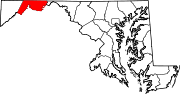
U.S. Highways Interstate Highways Categories:- State highways in Maryland
- Roads in Allegany County, Maryland


Wikimedia Foundation. 2010.